“Boosting” is smokejumper terminology for temporarily being stationed at a smokejumper base away from their home duty station.
Tag: California
Rocky Fire, east of Clearlake, California
(Our previous article about the Rocky Fire near Clearlake, California had been updated many times and was becoming large, so we are starting fresh with this article beginning August 2. It will continue to be updated.)
(An updated report on the Rocky Fire was published the morning of August 5, 2015)
****
(UPDATE at 6 a.m. PT, August 4, 2015)
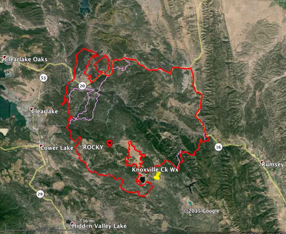
Yesterday we wrote that firefighters had been able to keep the Rocky Fire from crossing Highways 20 and 16. That changed Monday afternoon when airborne burning embers northeast of Clearlake, California started multiple spot fires across Highway 20. Some of the new fires merged (see the map above), leaving two large fingers of fire, one of them three miles long, heading north coming within three miles of Indian Valley Reservoir.
The good news is that the fire grew very little in other areas. It is still primarily west of Highway 16 and the perimeter on the south and southwest sides has expanded only a small amount over the last 24 hours.
Tuesday morning at 2:30 a mapping flight determined that the fire has blackened 68,810 acres.
CAL FIRE is still reporting 24 residences and 26 outbuildings destroyed by the Rocky Fire. Evacuations have affected at least 13,118 residents in 5,530 residences.
On Monday the Air National Guard’s Modular Airborne FireFighting System (MAFFS) C-130 air tankers recently activated flew 7 sorties dropping 20,476 gallons of fire retardant on the Rocky Fire.
The spotting across Highway 20 occurred in the afternoon during a period when winds out of the south were gusting up to 18 mph and the relative humidity reached a low of 16 percent. The forecast for Tuesday is for 83 degrees, 27 percent RH, winds out of the east then southeast at 2 to 7 mph, and mostly cloudy skies in the afternoon until 5 p.m. These weather conditions should moderate the fire activity compared to what firefighters saw on Monday.
****
(UPDATED at 6 a.m. PT, August 3, 2015)
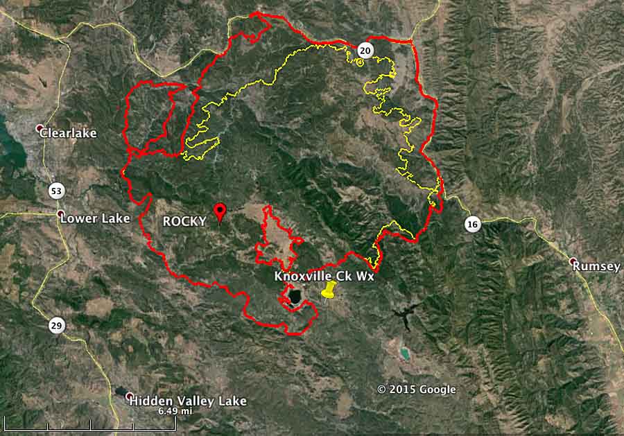
Firefighters continue to battle the Rocky Fire east of Clearlake and Lower Lake, California, which has grown to 60,000 acres. They are having some success on the north and east sides where the spread of the fire has been stopped in some places, for now, along Highways 20 and 16. But there is still a great deal of uncontrolled fire edge that must be dealt with.
The two highways, 20 and 16, are closed. CAL FIRE reports that evacuations are impacting over 12,000 residents, but that number has not been updated in a while. The number of residences destroyed, according to their information, remains at 24.
There was good relative humidity recovery overnight when it increased to 84 percent by 5 a.m., but it will slowly decrease on Monday to a low of 24 percent by 3 p.m. The maximum temperature will be 85 and in the afternoon the 2 mph southeast wind will increase to 10 mph out of the southwest around 5 p.m. These conditions on Monday morning will give firefighters a chance to make some headway on containing the fire, at least until mid-afternoon.
#rockyfire I’m on Olympic and Burns Valley Rd in the city of #Clearlake. #wildfire pic.twitter.com/mxtBPeLbEZ — Valerie Lemke (@FreelanceRoad) August 3, 2015
**** (UPDATED at 8:39 p.m. PT, August 2, 2015) CAL FIRE is calling the Rocky Fire east of Clearlake, California 54,000 acres and 5 percent contained as of Sunday evening.
Plume of smoke from #RockyFire in #California. http://t.co/YN7Bq1K9zT #CalWildfires (Pic @abc7newsBayArea) pic.twitter.com/aGA3qaVw03 — Ed Joyce (@EdJoyce) August 3, 2015
****
(Originally published at 9:35 a.m. PT, August 2, 2015)
The Rocky Fire east of Clearlake, California more than doubled in size on Saturday. CAL FIRE reported that it had burned 22,500 acres on Saturday morning, and a mapping flight at 2 a.m. Sunday determined that it had exploded, again, and has now blackened 47,000 acres. Two highways in the area are closed, Highways 20 and 16. (See the map below.)
The weather conditions on Saturday were fairly conducive to significant fire spread — 95 degrees, 21 percent relative humidity, and southwest winds at 8 mph gusting up to 17. The forecast for Sunday is somewhat more moderate — 90 degrees, 32 percent RH, and winds switching from the west to south at 2 mph increasing to 9 mph in the afternoon.
Combined with low vegetation (fuel) moisture, another 25,000 acres went up in smoke Saturday as the fire spread to the north and east coming close to, and in some areas reaching, Highway 20 on the north and 16 on the east. CAL FIRE reported at 7:45 Sunday morning that the fire had not crossed the roads. Firefighters were burning out or backfiring ahead of the fire in some places along the highways.
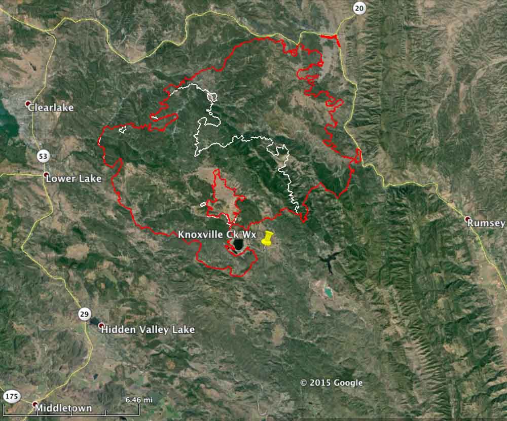
The Rocky Fire has destroyed 24 residences and 26 outbuildings, according to CAL FIRE. Evacuations have impacted over 12,190 citizens living in 5,201 residences.
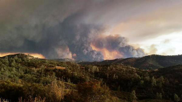
New lightning fires in Shasta-Trinity NF burn 19,000 acres
(UPDATE at 9 a.m. PT, July 2, 2015)
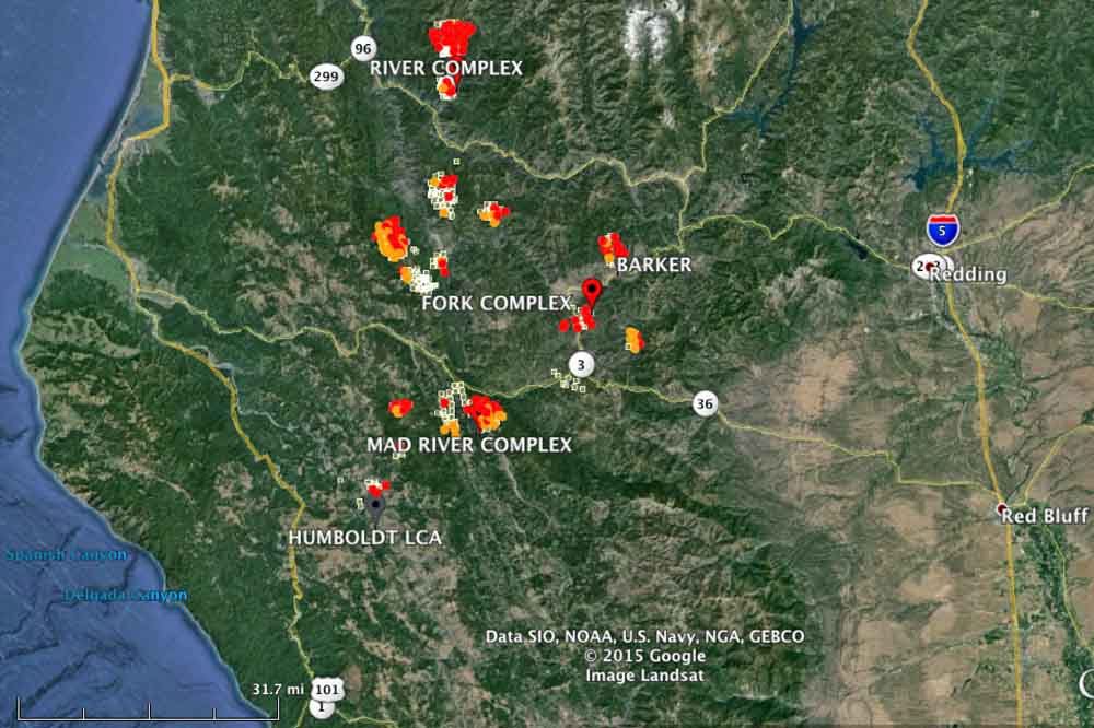
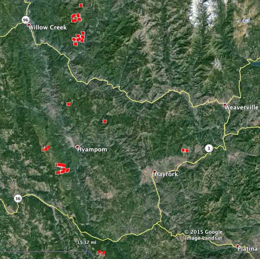
The management of the new lightning-caused wildfires detected in the last 48 hours between Redding and Eureka, California has been organized into at least three “complexes” of fires. Above is a recent map showing heat detected in the area by a satellite at 2:44 a.m., August 2, 2015.
****
(Originally published at 9:31 am PT, August 1, 2015)

An infrared mapping flight over the Shasta-Trinity National Forest Friday night west of Redding, California detected numerous fires that together have burned 19,000 acres over the last 48 hours. The Shasta-Trinity clearly has a massive wildfire situation on their hands. These lightning-caused fires have grown significantly in the last 36 hours.
The area is under a Red Flag Warning for “abundant lighting” Saturday afternoon. Wetting rain is not expected to accompany the lighting.
More information about these fires is HERE.
South Dakota firefighter killed while responding to a fire in California
By Ken Sandusky, U.S. Forest Service,
released at 7:45 p.m PT, July 31, 2015
****
“Alturas, Calif. – It is with great sadness we must confirm a Forest Service firefighter lost his life yesterday while responding to the Frog Fire northwest of Adin, California (map). The deceased is David “Dave” Ruhl of Rapid City, South Dakota.
Search and rescue was conducted throughout the night until the firefighter was found this morning.
Dave was on temporary assignment to the Big Valley Ranger District of the Modoc National Forest as an Assistant Fire Management Officer since June 14. Dave’s permanent position is Engine Captain on the Mystic Ranger District of the Black Hills National Forest in Rapid City.
The Forest Service is investigating this line-of-duty death.
“This loss of life is tragic and heartbreaking,” said Forest Supervisor, Amanda McAdams. “Please keep the family and all of our Forest Service employees in your thoughts and prayers during this difficult time.”
The Frog Fire southeast of Lava Camp on the Big Valley Ranger District started yesterday afternoon, exhibiting active fire behavior and growing to more than 800 acres by this evening with active spotting ahead of the fire front.
Northern California Team 1 is expected to take over management of the fire Saturday morning.
Additional detailed information on the Frog Fire will be available on Inciweb at http://inciweb.nwcg.gov/incident/4427/.”
****
California Governor Brown also issued a statement about the fatality and mentioned that Mr. Ruhl is survived by his wife, Erin, and their two children. He worked for the U.S. Forest Service for 14 years and previously served in the U.S. Coast Guard.
In honor of Firefighter Ruhl, California Capitol flags will be flown at half-staff.
At Wildfire Today our sincere condolences go out to Mr. Ruhl’s friends, co-workers, and family.
The Rocky Mtn Area is deeply sorry to hear of the loss of SD firefighter, Dave Ruhl. #RIP pic.twitter.com/HgYah0ldDq
— RMACC (@RMACCinfo) August 1, 2015
Satellite photo of smoke from west coast fires
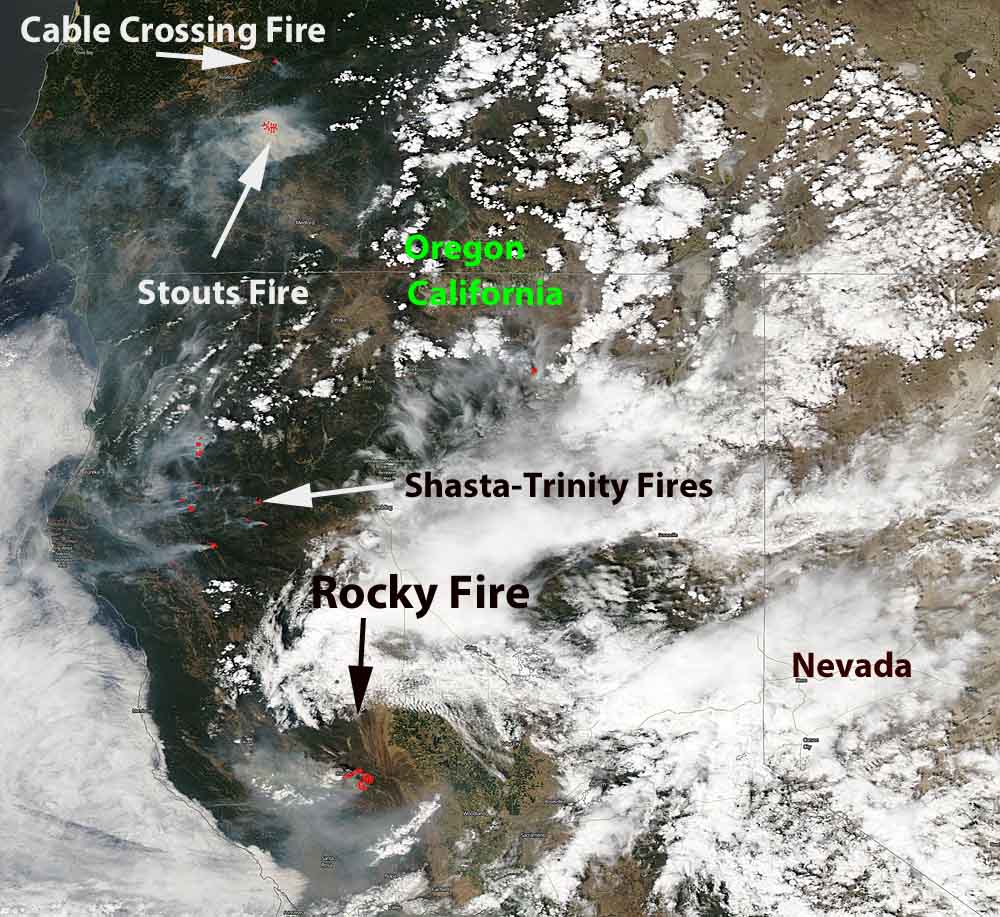
The photo above shows smoke that is being created by the fires in northern California and southwest Oregon. The red dots represent heat detected by a satellite on the fires. Generally to the west, or left, of the red dots you can see the white smoke being blown to the west. The rest of the white on the image is clouds. Click on the image to see a larger version.
The satellite image was captures in the late afternoon on Friday.
The Rocky Fire is threatening towns northwest of Sacramento, California, including Clearlake, Lower Lake, and Twin Lake.
Dozens of new lightning-caused fires have been detected in the last 24 hours on the Shasta-Trinity National Forest between Redding and Eureka, California in northwest California.
The Stouts Fire 10 miles east of Canyonville, Oregon exploded to 6,500 acres within 12 hours after it started on Thursday.
To see the most current smoke reports on Wildfire Today, visit the articles tagged “smoke” at https://wildfiretoday.com/tag/smoke/
Dozens of new fires on Shasta-Trinity NF in California
(UPDATED at 8 a.m. PT, August 1, 2015)
The Shasta-Trinity clearly has a massive wildfire situation on their hands. The lightning-caused fires detected Friday have grown significantly in the last 24 hours. Compare the map below with the similar zoomed in image at the bottom of this article.
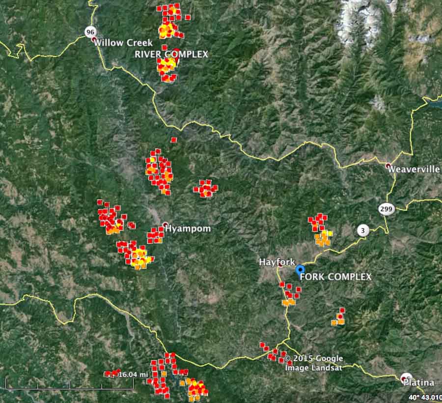
Friday night a spokesperson for the Shasta-Trinity National Forest reported that over the previous 48 hours the forest received 440 lightning strikes that resulted in over 60 fires. The largest of these fires is the Rail Fire near the town of Hayfork and is approximately 800 acres.
The County Sheriff issued mandatory evacuations because of the numerous fires around the towns of Hyampom, Trinity Pines, and the small communities outside Hayfork. A Red Cross Shelter is at the Solid Rock Baptist Church in Hayfork. The Trinity County Sheriff’s office or local law enforcement officials have the most current and detailed evacuation information.
To make matters worse, the area is under a Red Flag Warning for “abundant lighting” Saturday afternoon. Wetting rain is not expected to accompany the lighting.
Unless there is an extraordinary change in the weather over the next several weeks, this fire fight will last until the snow falls.
****
(Originally published at 8:47 a.m. PT, July 31, 2015)
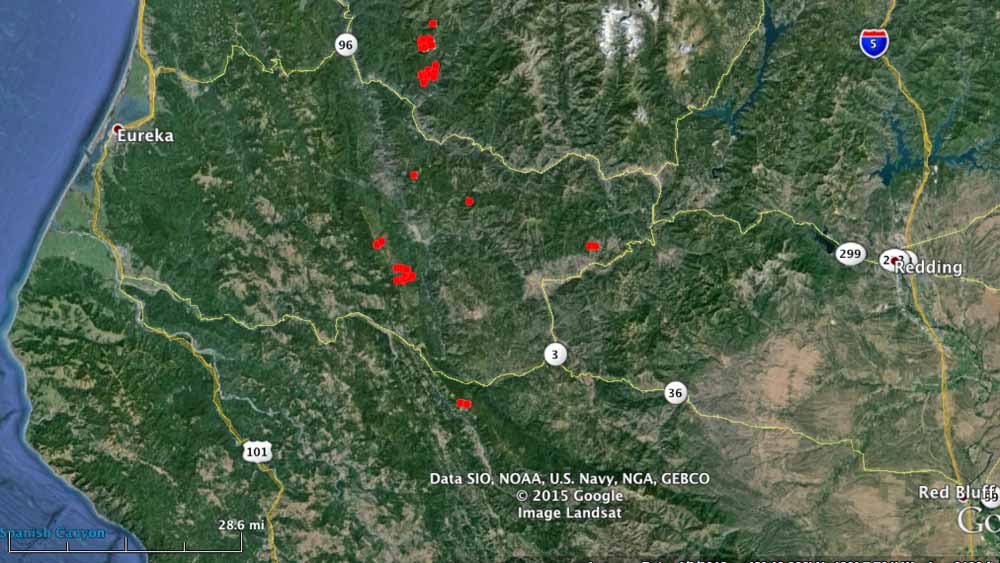
The Shasta-Trinity National Forest has at least 30 new fires, some large already, between Redding and Eureka, California (see the maps above and below). Storms on Thursday brought 150 lightning strikes that ignited the fires. Small towns in the general vicinity include Hyampom, Weaverville, Hayfork, Denny, and Willow Creek.
Three of the fires west of Denny and southwest of Hyampom appear from the satellite imagery to be more than 100 acres each.
The count of 30 fires was reported by the Shasta-Trinity NF at 7:20 p.m on Thursday, so there could be more that will be detected over the next couple of days.

