The fire started at around the same time the power company reported “circuit activity”
Updated 8:23 p.m. PDT Sept. 7, 2022
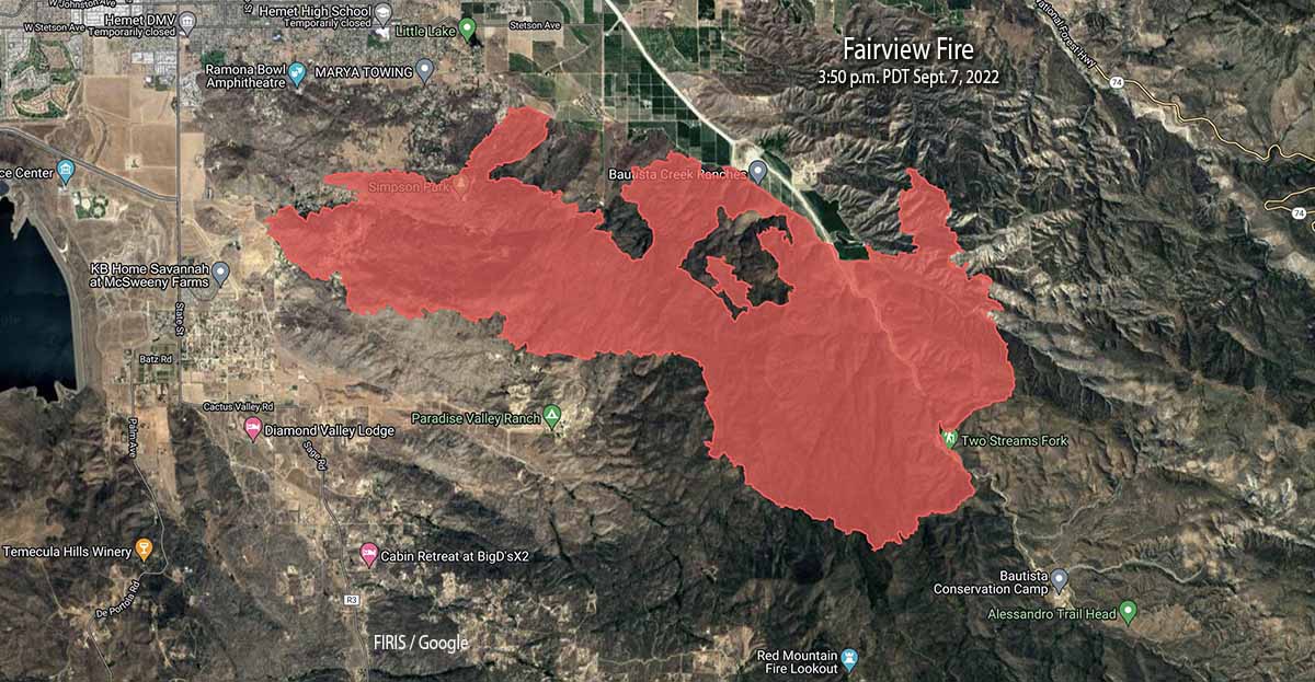
Fairview Fire map, 3:50 p.m. Sept 7, 2022.
When the Fairview Fire was mapped at 3:50 p.m. Wednesday most of the recent growth was on the east side, on both sides of Baustista Canyon Road. The FIRIS aircraft determined that it was 9,840 acres.
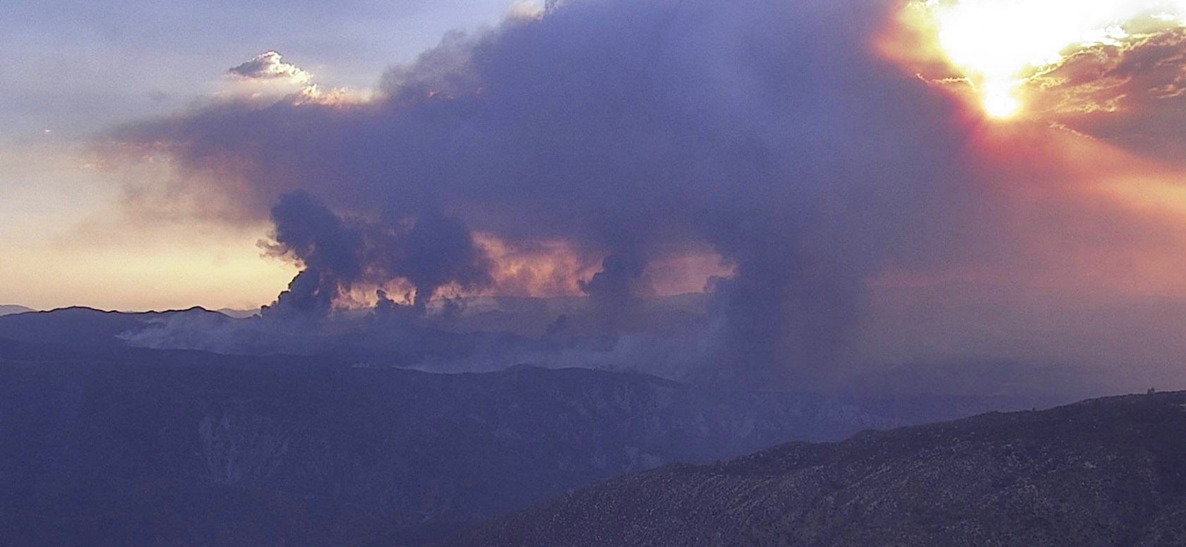
Fairview Fire, as seen from the Idyllwild fire camera looking WSW at 6:16 p.m. Sept 7, 2022.
Updated at 1:52 p.m. PDT Sept. 7, 2022
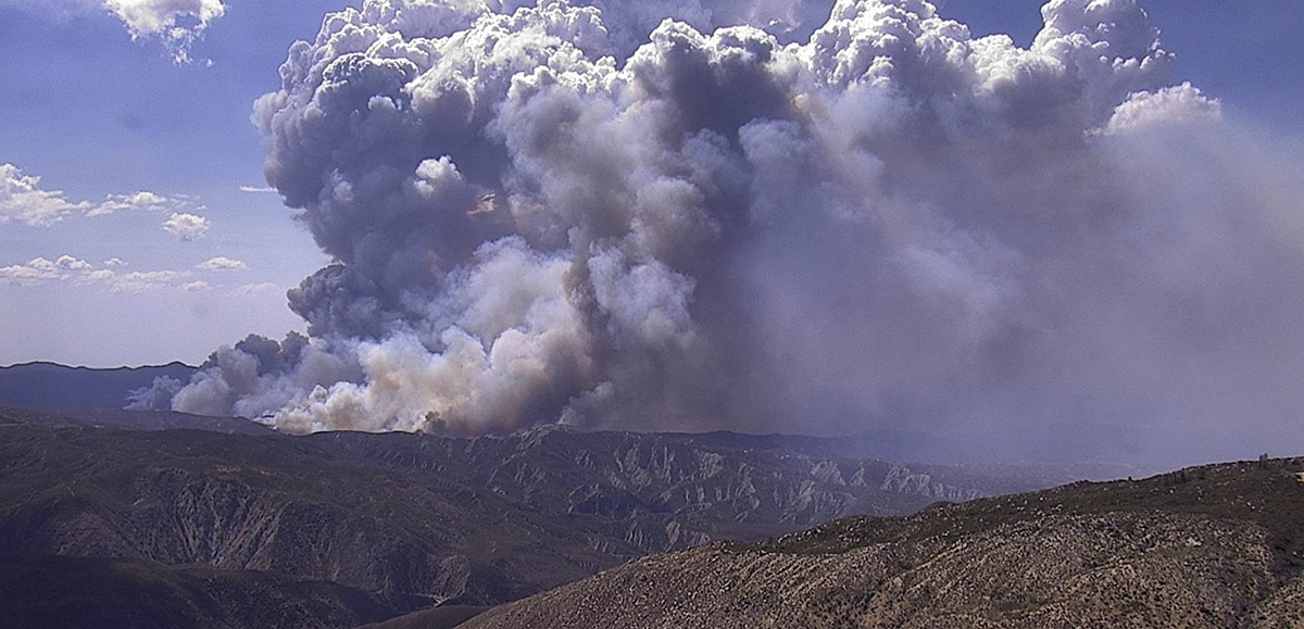
Fairview Fire south of Hemet, CA, looking west-southwest from the Idyllwild camera at 149 p.m. PDT Sept. 7, 2022.
Updated 12:58 p.m. PDT Sept. 7, 2022
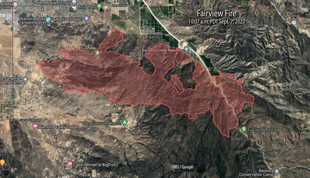
Fairview Fire map 10:07 a.m. Sept. 7, 2022.
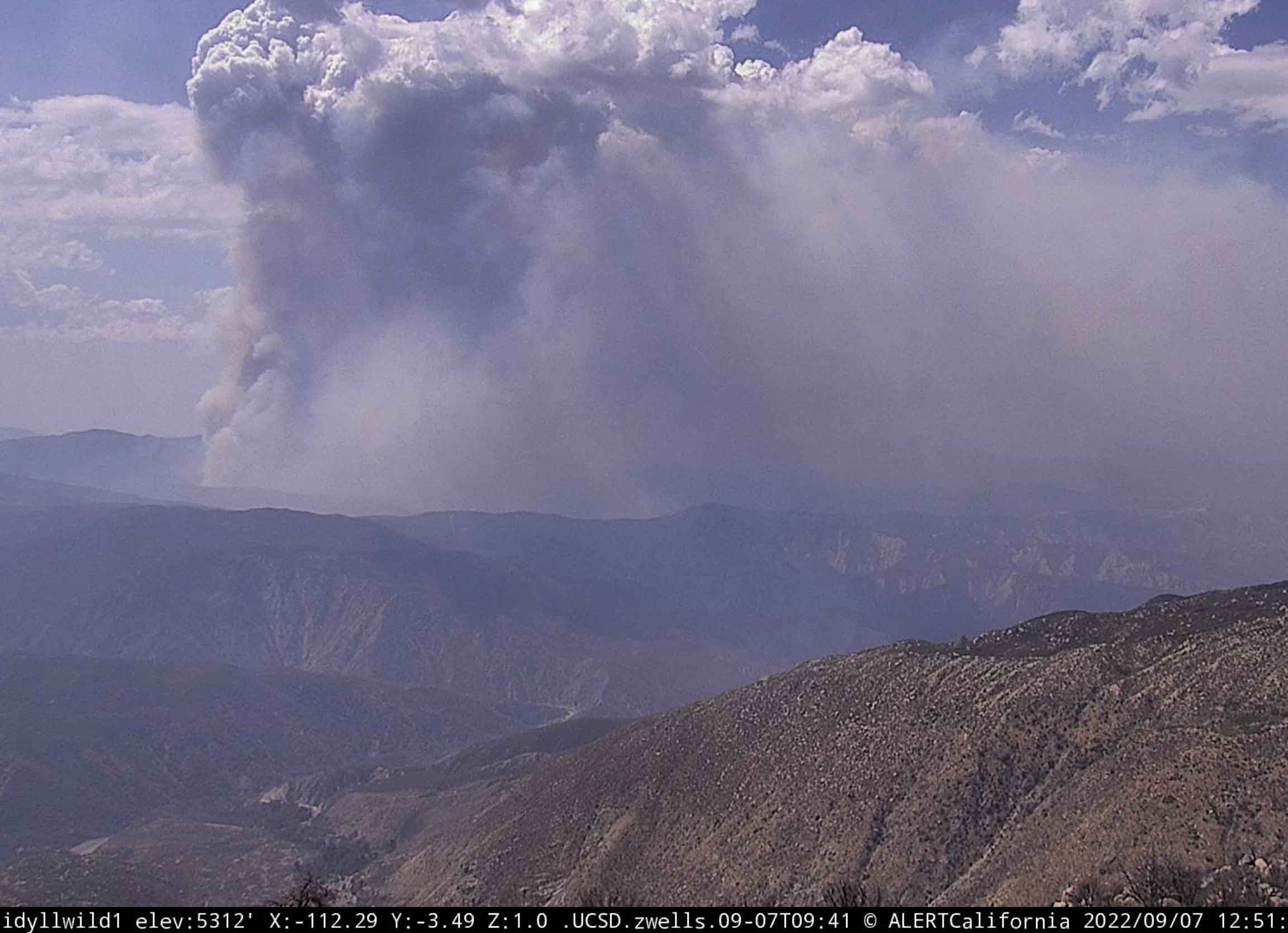
Wednesday morning CAL FIRE said the Fairview Fire southeast of Hemet, California has grown to 7,091 acres. Activity on the fire began to increase at around noon on Wednesday as you can see in the photo below.
Fairview Fire, looking west-southwest from the Idyllwild camera at 12:51 p.m. Sept 7, 2022
Much of the spread over the last 24 hours was on the north and east sides. It reached Baustista Canyon Road in several places where the additional spread was stopped by agricultural land. But at Blackburn Canyon there was nothing but brush on both sides and it spotted across the road. When the fire was mapped at 10:07 Wednesday morning it had run east beyond the road for nearly a mile through rugged country. At that time it was about three miles west of Highway 74.
On the west side of Baustista Canyon Road where it burned across, is the fire scar from the 2019 Fairview Fire which blackened 1,740 acres. That three-year old footprint was not a major barrier. Nor was, on the east side of the road, two fires from 2001, the 181-acre Baustista Fire and the 262-acre Canyon Fire.
Following those barriers of little consequence there is no recent fire history to the east of the Fairview Fire until it reaches Highway 74 and the Mountain Center Area where the 2018 Cranston Fire burned 13,229 acres, and further to the north, the 2,410-acre Cottonwood Fire of 2009.
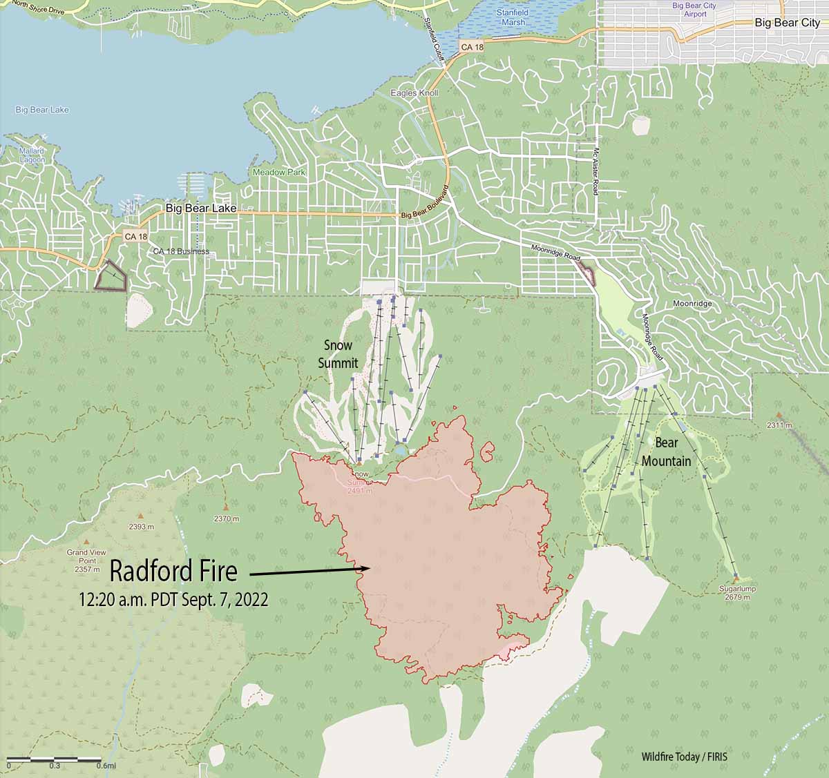
The Radford Fire at Big Bear Lake in Southern California was mapped at 1,052 acres at about 12:30 p.m.
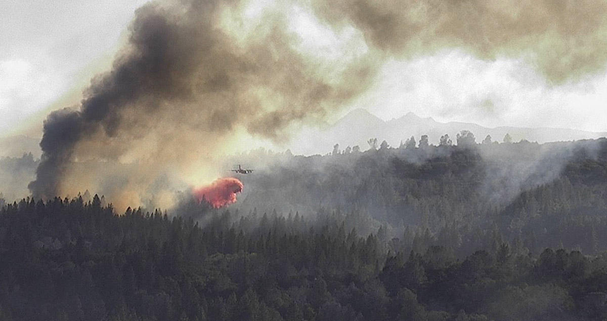
The video below shows a hotshot crew conducting a burning operation on the fire.
The next video was shot by the FIRIS mapping aircraft at 11:17 a.m. Wednesday. When it switches from visual to infrared, the white areas represent heat. If you look carefully you may see some circular black areas along a ski run where sprinklers have been activated.
As the sun came up Wednesday morning cameras showed the Radford Fire near Big Bear Lake in Southern California was very active. A 12:20 a.m. mapping flight found that it had grown to about 980 acres and had spread 0.4 mile north of Skyline Drive/FR 2N10. At that time it was between the two ski areas, Snow Summit and Bear Mountain, but was still high on the slopes, about 0.8 mile from Switzerland Drive.
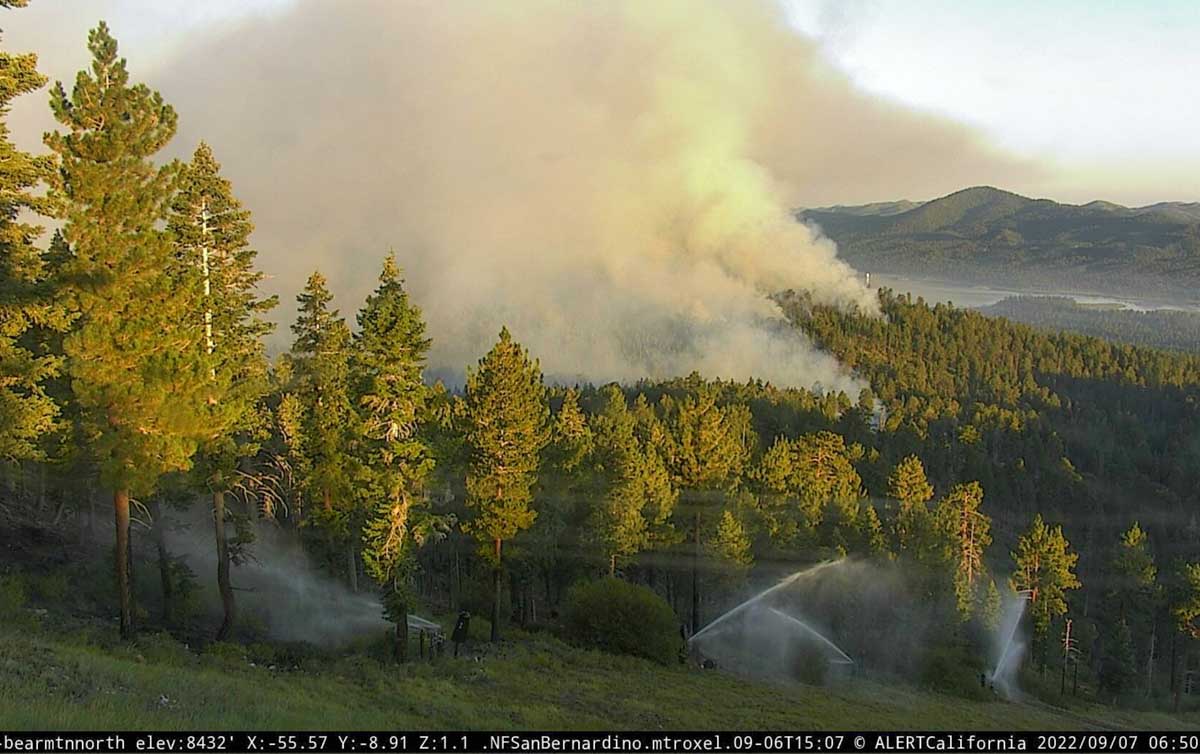
Radford Fire as seen from the Bear Mtn. camera looking northwest at 6:50 a.m. Sept. 7, 2022. Snow making infrastructure is being used to wet down the vegetation near the ski runs.
The ski areas are using the water systems for the snow making machines to wet down the vegetation on the ski runs.
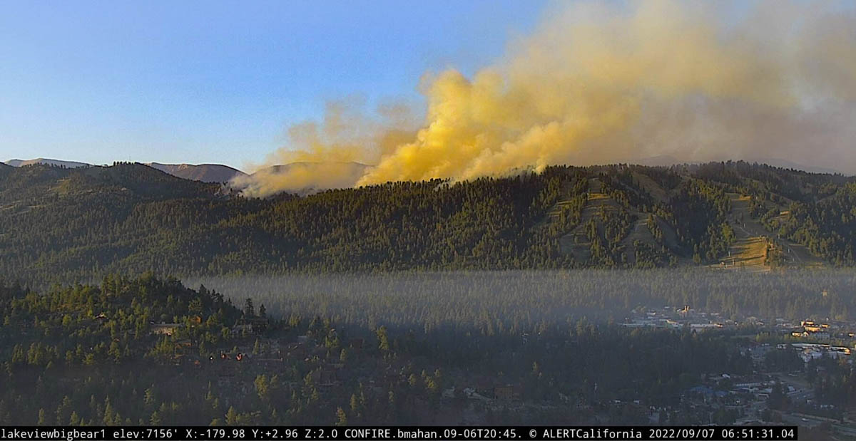
Radford Fire as seen from the Lakeview Big Bear camera looking south at 6:51 a.m. Sept. 7, 2022.
Evacuations are in effect. The San Bernardino County Sheriff’s Office has the current details.
#RadfordFire Evacuation Warnings⚠️:
The area of Club View east to Angles Camp Rd & Vine Ave south to Lassen Dr.
Summit Blvd east to McAllister Rd, east of Hwy 18 & Fox Farm Rd south to Evergreen Rd.
— San Bernardino County Sheriff (@sbcountysheriff) September 7, 2022
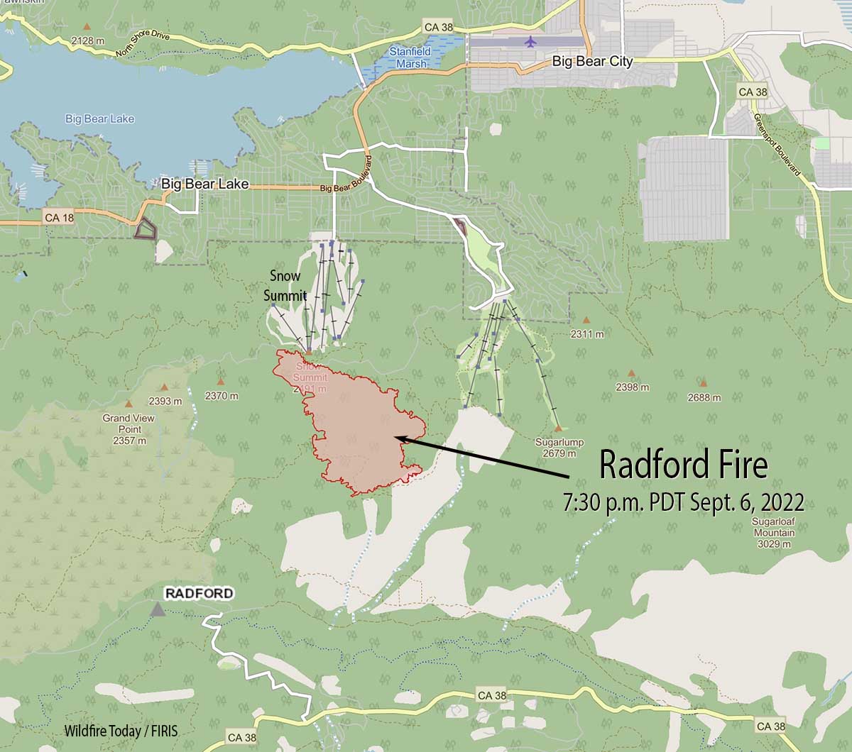
Updated 10:34 p.m. PDT September 6, 2022
Radford Fire Map 7:30 p.m. Sept. 6, 2022.
The Radford Fire south of Big Bear Lake has spread to and crossed over the NF-2N10 road above the Snow Summit ski area. The US Forest Service says the fire has grown to 917 acres.
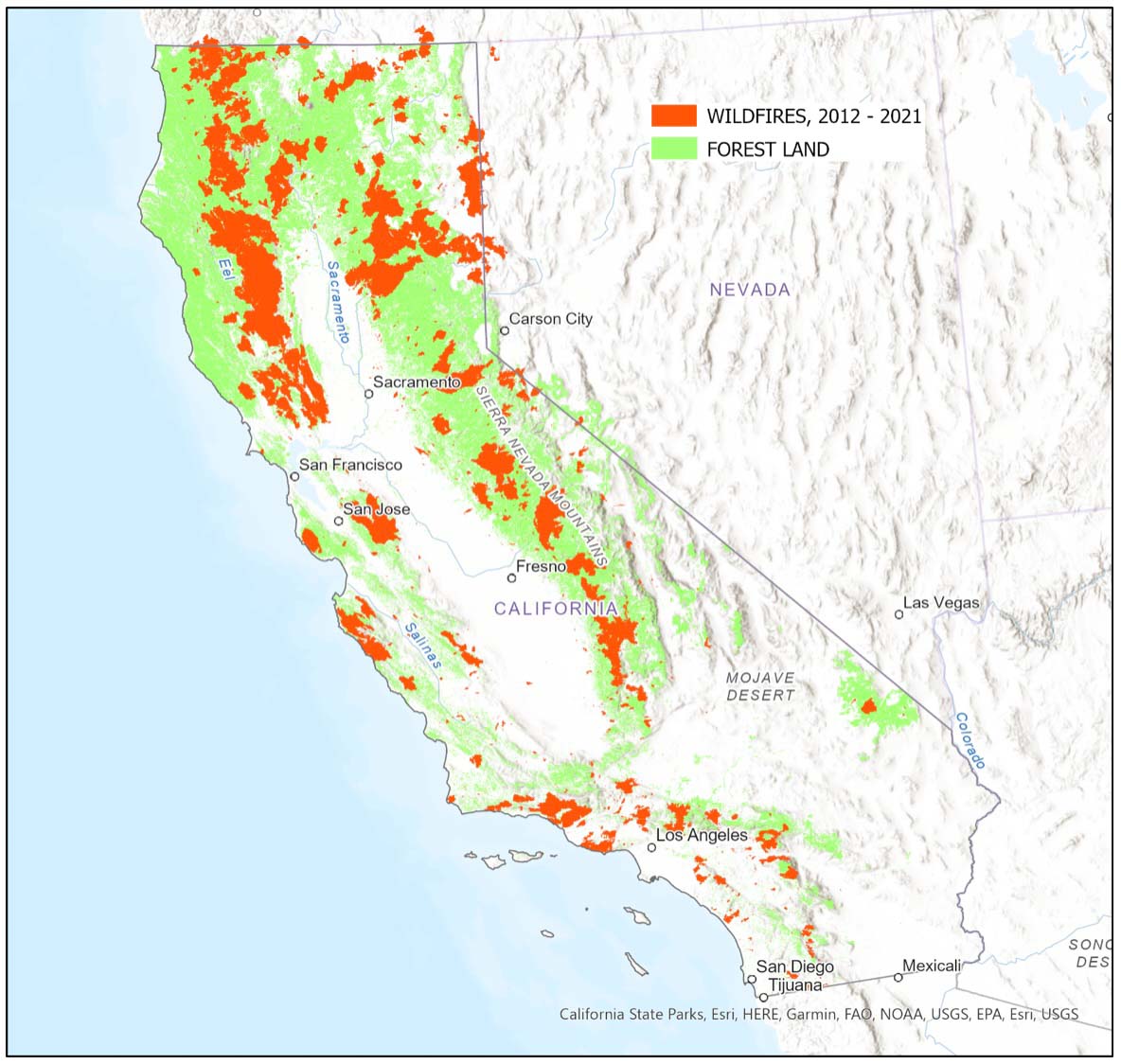
About 25 percent of the states’ forestland burned in the last 10 years — more than triple the previous decade
BAe-146 drops on the Winding Fire in Northern California June 18, 2022. InciWeb.
By Jim Schmidt
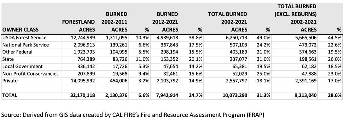
Of the 32.1 million acres of forestland in California, approximately 2.1 million acres (6.6%) burned in wildfires in the 2002-2011 time period. In the following decade (2012-2021), that figure more than tripled to 7.9 million acres (24.7%).
National Forests in California were particularly hard hit. 10.1% of 12.7 million acres of forestland managed by the USDA Forest Service in California burned in 2002 – 2011 time period. In the 2012 – 2021 decade that figure increased to 38.8%. Excluding areas that re-burned in the last 10 years, 44.5% of the forestland in California National Forests has burned in the last 20 years. In contrast, only 22.6% of National Park forestland in the state has burned in the same time period. About 14 million acres of forestland in California are in private hands. 17.0 % of private forestland has burned since 2001.
Forestland acres burned by wildfires in California by owner class, 2002 – 2021. Jim Schmidt
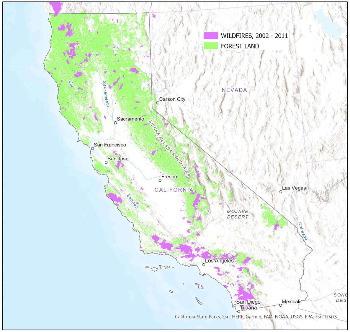
The following maps display the forestland areas and the areas that have burned in California in the last two decades. Fires were concentrated in Southern California in the 2002-2011 time period and in Northern California in the last 10 years.
California forestland and wildfires, 2002 – 2011. Jim SchmidtCalifornia forestland and wildfires, 2012 – 2021. Jim Schmidt
The article was edited September 7 with revised figures to account for areas that reburned, which account for about 5% of the forestland burned on National Forests in the last 20 years.
Jim Schmidt retired from the Stanislaus National Forest where he worked as a GIS specialist.
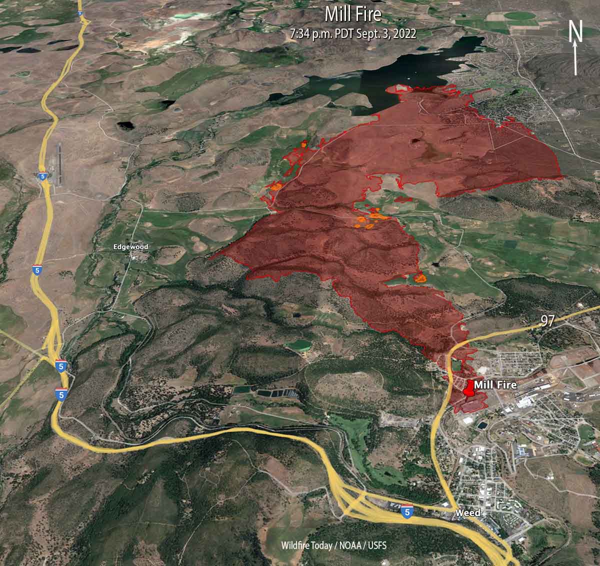
Mill Fire 3-D map, looking north at 7:34 p.m. PDT Sept. 3, 2022. The small orange areas represent intense heat.
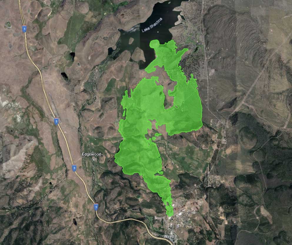
Two wildfires in Northern California, the Mill and Mountain Fires, have burned a total of more than 10,000 acres in and near the town of Weed 56 air miles north of Redding. Both fires are being suppressed by CAL FIRE’s Incident Management Team 5.
Mill Fire
The fire is believed to have started near a lumber mill where it destroyed a commercial building and spread very rapidly through a portion of the town of Weed. It continued for another five miles to the north until it reached Lake Shastina.
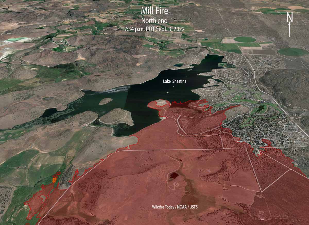
Map of the north end of the Mill Fire, looking north at 7:34 p.m. PDT Sept. 3, 2022. The small orange areas represent intense heat.
Initially working with aerial imagery, officials determined that 132 structures had been affected. Damage assessment teams began ground truthing the information on Sunday. The initial early estimates from the Mayor of Weed and a CAL FIRE Unit Chief were that 100 homes were destroyed.
Evacuation orders and warnings are still in place but officials are repopulating areas where safely possible. A map is at Zonehaven.
Additional growth of the Mill Fire on Saturday was minimal. It was mapped Saturday evening at 4,254 acres.
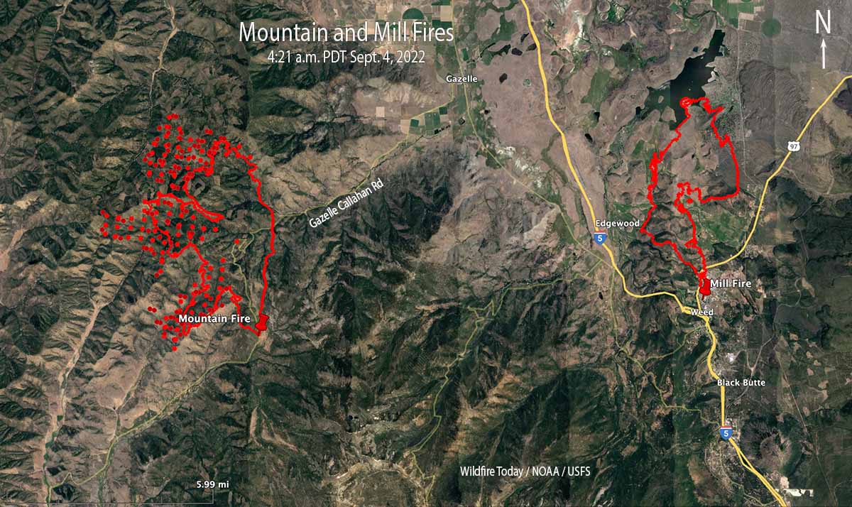
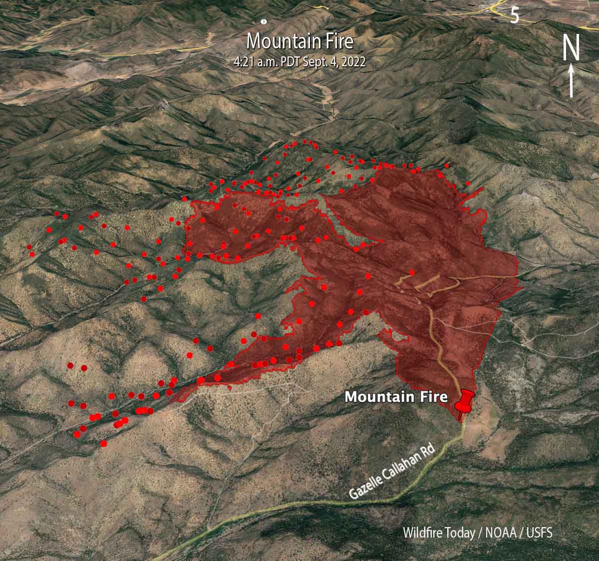
Map of the Mountain and Mill Fires. The red dots represent heat detected by satellites at 4:21 a.m. PDT Sept. 4, 2022. The red lines were the perimeters at about 7:40 p.m. Sept. 3, 2022.
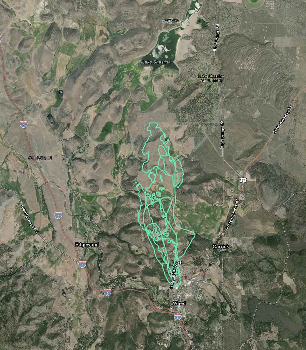
Mountain Fire
About 12 miles west of Weed the Mountain Fire had burned 6,451 acres when it was mapped Saturday evening, but it continued to spread into the night to the north and west. There have been no reports of destroyed structures and 685 remain threatened. Approximately 332 people have been evacuated.
The fire is very different from the Mill Fire. There are fewer structures close to where it is presently burning, it is in remote, rugged terrain, and there is little road access. Fire behavior in the last 48 hours has been described as extreme, with hazardous trees, snags, strong gusty winds, and high temperatures. The area ranges from 2,700′ to 6,000′ elevation. On September 2 a Fuels and Fire Behavior advisory was issued for Northern California due to extreme drought, extremely dry fuels, and extended periods of hot weather. It warned that fire behavior would be elevated for the near future.
Mountain Fire 3-D map looking north. The red dots represent heat detected by a satellite at 4:21 a.m. PDT Sept 4, 2022. The red line was the perimeter at about 7:40 p.m. Sept. 3, 2022.
There is no nearby significant recorded history of fire in the National Interagency Fire Center database. However that database is often lacking complete information. The fire has the potential for growth in all directions, including through numerous clear cuts with dry, light to medium flashy fuel.
Threatened communities include Gazelle and Scott Valley.
Multiple structures have been destroyed. A second fire, the Mountain Fire, is burning 12 miles west of Weed.
Updated at 8:30 p.m. PDT Sept. 3, 2022
Mill Fire
At 7 p.m. Saturday CAL FIRE reported that damage assessment imagery indicates 132 structures have been affected by the Mill Fire. This includes all structures of any kind including outbuildings that were damaged or destroyed. On Sunday damage assessment teams will begin ground truthing the data. The size has been updated to 4,254 acres and about 1,000 residents have been evacuated.
Mountain Fire
Also at 7 p.m. CAL FIRE said the Mountain Fire east of Weed, CA has burned 4,812 acres. There have been no reports of destroyed structures and 690 remain threatened. Approximately 332 people have been evacuated.
At 4 p.m. on Saturday CAL FIRE Incident Management Team 5 assumed command of both fires.
Updated 4:31 p.m. PDT Sept. 3, 2022
The Sacramento Bee is reporting that 100 homes have been destroyed in the Mill Fire, according to the Mayor and a CAL FIRE Unit Chief. Most of the homes were in the Lincoln Height area.
Scenes of the wreckage from the #MillFire burning in Siskiyou County. These are homes just off Highway 97, off Lincoln Ave. and on Wakefield Ave. in Weed
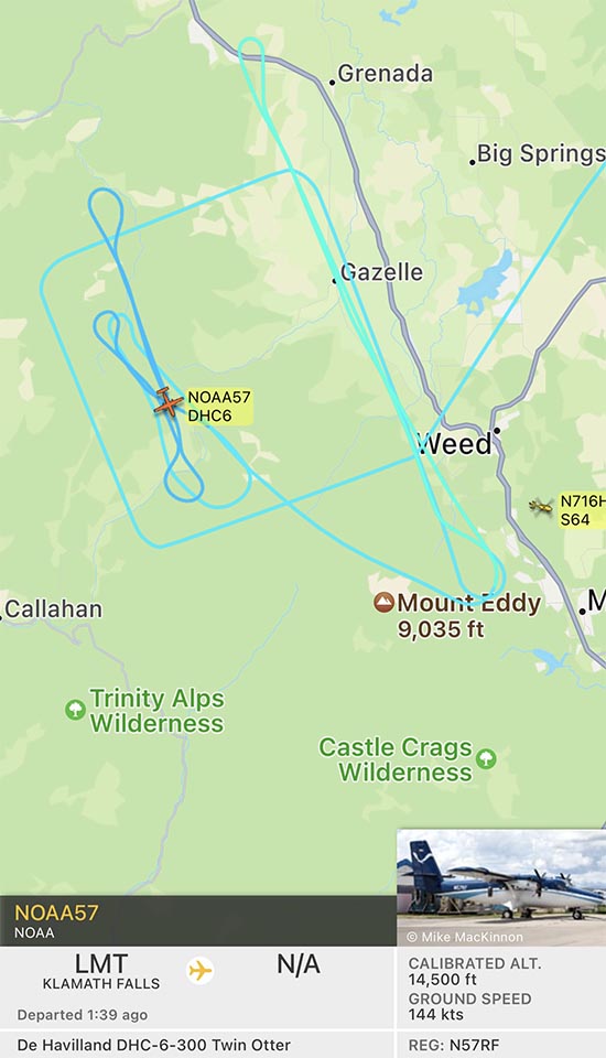
However, there is a NOAA Twin Otter aircraft flying an interesting square pattern over the fire at 14,500 feet. It may be collecting smoke or air quality data.
Updated 7:22 a.m. PDT Sept. 3, 2022
Map of the Mountain and Mill Fires 3:02 a.m. Sept. 3, 2022.
The 3,921-acre Mill Fire has destroyed multiple structures in the town of Weed, 56 air miles north of Redding California. Videos posted online showed residential areas burning as well as one industrial building. Thermal imagery recorded by the FIRIS mapping aircraft showed intense heat at the site of dozens of structures.
Map showing heat (white areas) detected by the FIRIS aircraft at the Mill Fire at 2:01 p.m. Sept. 2, 2022.
The spread of the Mill Fire slowed overnight as the winds that were gusting at more than 20 mph hour Friday afternoon decreased to 4 mph after midnight and the relative humidity rose to 54 percent.
The Mayor of Weed told the LA Times that the fire appeared to have started at a lumber mill near the town.
Suzi Brady, a CAL FIRE spokeswoman, said several people were injured. At least two were treated at hospitals, NPR reported.
Another fire in the area, the Mountain Fire, was very active through the night. It has spread about five miles north since it started near Gazelle Callahan Road 12 air miles west of Weed. It is about 6 miles southwest of Gazelle. CAL FIRE reports it has burned 1,464 acres, but current unofficial estimates put it more than double that figure.
Both fires are burning primarily on private land, but the Mountain Fire started near the boundary of the Shasta-Trinity National Forest and burned some of the Forest east of Gazelle Callahan Road.
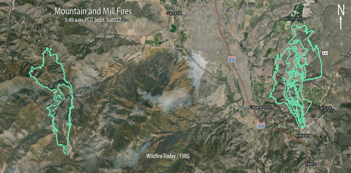
Map of the Mountain and Mill Fires by the FIRIS aircraft, ~5:49 a.m. Sept. 3, 2022.
The Mill Fire has light fuel loadings out ahead, and to the east is the burn scar of last year’s 26,000-acre Lava Fire.
The Mountain Fire on the other hand is surrounded by private timber land with no significant recorded history of fire in the National Interagency Fire Center database. However that database is often lacking complete information. It has the potential for growth in all directions, including through numerous clear cuts with dry, light to medium flashy fuel.
At about 8:10 p.m. the FIRIS aircraft mapped the Mill Fire at 3,921 acres, showing that it had burned from Weed, California north to the shore of Lake Shastina, a distance of nearly six miles.
The Mountain Fire 12 air miles west of Weed near Gazelle Callahan Road has burned approximately 700 acres. It is about 9 miles southwest of Gazelle.
Weather
Friday afternoon a weather station just southeast of Weed recorded 89 degrees, 7 percent relative humidity, and 12 mph winds gusting at 20 to 26 mph out of the east-southeast.
Friday night the winds should decrease to 5 to 10 mph out of the south after sunset, then decrease to 2 to 4 mph after midnight with a maximum RH of 45 percent.
The spot weather forecast for Saturday predicts 88 degrees, 12 percent RH, and winds out of the north at 1 to 3 mph.
The slower wind speeds should give firefighters a chance to put in some direct fireline on Saturday.
5:32 p.m. PDT Sept. 2, 2022
Map showing location of the Mill and Mountain Fires, near Weed, California Sept. 2, 2022.
A fire reported at about 12:58 p.m. PDT is threatening structures in the town of Weed which is northwest of Mt. Shasta, 56 air miles north of Redding California.
The blaze is moving rapidly to the north. The southernmost end of the fire is near US Route 97 east of Interstate 5.
Growth of the Mill Fire as tracked by FIRIS the afternoon of Sept. 2, 2022; time uncertain. The fire has grown substantially since this map was created.
Evacuations are in effect; the details and a map are at Zonehaven.
The last size released was 1,228 acres, but the blaze has grown substantially since then.
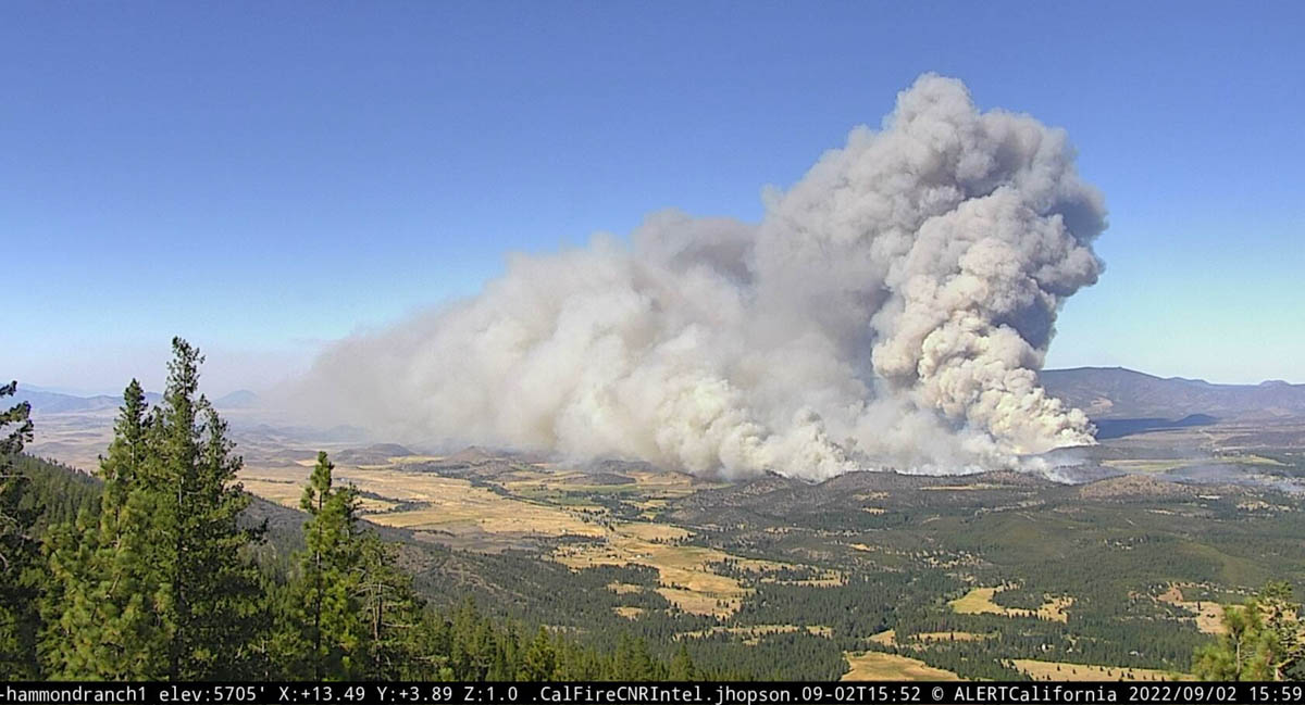
Mill Fire, looking north-northeast from the Hammond Ranch camera at 3:59 p.m. Sept. 2, 2022.
There are widespread power outages in the area which is affecting multiple nearby AlertWildfire cameras.
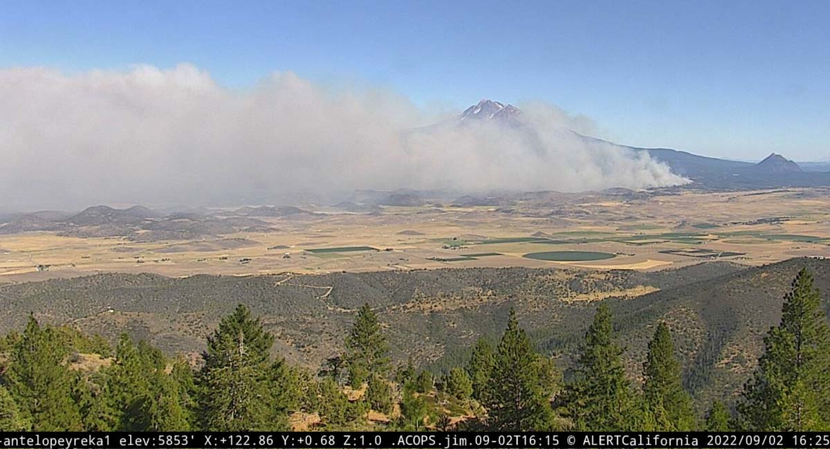
Mill Fire, looking southeast from the Antelope Yreka camera at 425 p.m. Sept. 2, 2022.
Mountain Fire
Another fire in the general area that started Friday afternoon is the Mountain Fire 12 air miles west of Weed near Gazelle Callahan Road. Both fires are creating very large smoke plumes and are spreading rapidly. The Mountain Fire was reported at 4:19 p.m. Shortly after 5 p.m. Air Attack estimated it had burned about 300 acres.
We will update this article as more information becomes available.
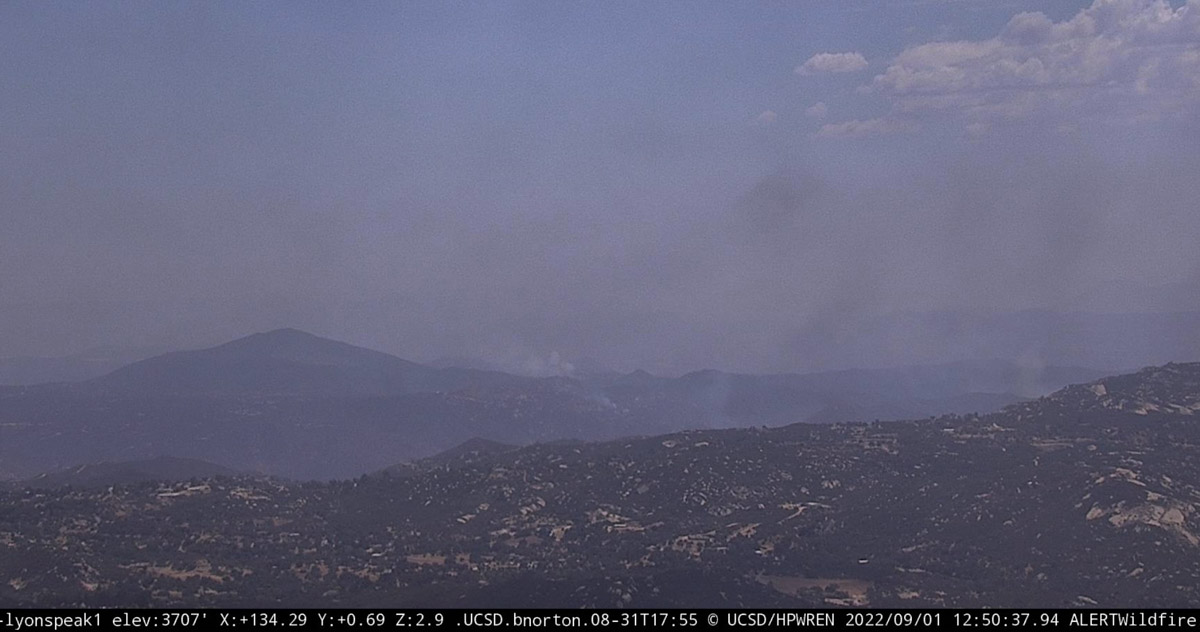
Border 32 Fire, looking southeast from Lyons Peak at 12:50 p.m. Sept. 1, 2022.
The Border 32 Fire which is burning in Southern California on both sides of Highway 94 between Barrett Junction and Potrero was mapped at 4,438 acres at 10:51 a.m. by the FIRIS aircraft. That is an increase of about 200 acres over the previous 24 hours.
The cameras are showing minimal fire activity, but that could change during the heat of the afternoon.
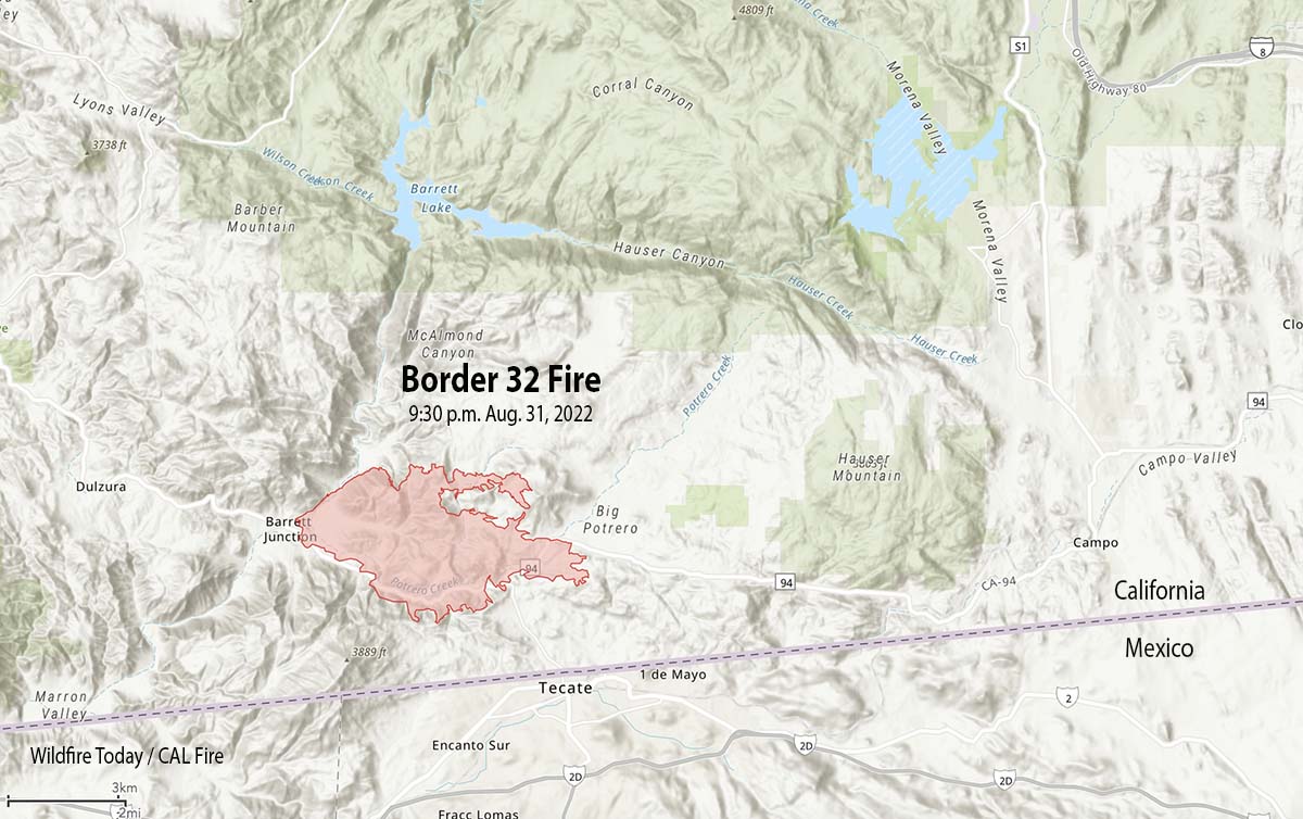
Updated 6:04 a.m. PDT Sept. 1, 2022
Border 32 Fire, vicinity map 9:30 p.m. Aug. 31, 2022.
At around sunset on Wednesday the Border 32 Fire spread across Highway 94. When the fire was mapped at about 9:30 p.m. it was on both sides of the highway for a two-mile stretch along the highway just west of Tecate Road. At that time it was very close to Potrero, 1 mile from Tecate, 1 mile from the US/Mexico border, 4 miles west of Canyon City, and 8 miles west of Campo.
At least four structures are reportedly destroyed and more than 400 residences are affected by evacuations.
The 9:30 mapping flight determined it had burned 4,243 acres.
Border 32 Fire map 9:30 p.m. Aug. 31, 2022.
CAL FIRE said at 11 p.m. on Wednesday that the fire continues to threaten Barrett, Potrero, and Tecate.
The Customs and Border Protection said the Tecate border crossing will not open Sept. 1 at the usual time of 6 a.m. but will remain closed. The Otay Mesa crossing is an alternative.
The San Diego County Sheriff’s office has ordered evacuations. They have posted a map showing the areas affected.
After Wednesday night at 9 p.m. the wind speeds decreased from 15-20 to 5 mph, slowing the spread of the fire. The maximum relative humidity overnight was 36 percent. The spot weather forecast for Thursday calls for 107 degrees, 20 percent RH, and south winds up to 8 mph shifting to the west at 12 mph with gusts to around 20 mph in the afternoon.
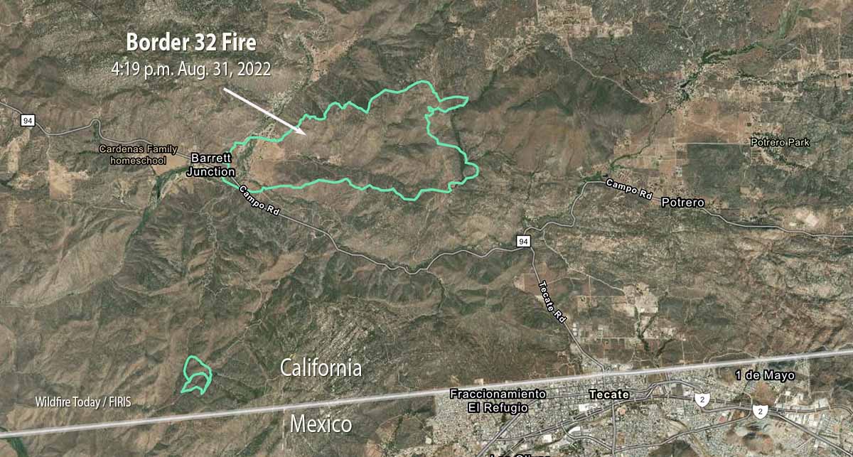
Updated 5:29 p.m PDT August 31, 2022
Map of the Border 32 Fire, 4:19 p.m. Aug. 31, 2022.
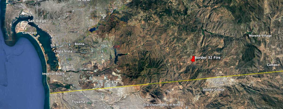
The Border 32 Fire grew rapidly after it was reported southeast of San Diego Wednesday at about 2:30 p.m.
The blaze is about 5 air miles west of Potrero, the same distance northwest of Tecate, and 3 miles north of the US/Mexico border.
It is spreading quickly primarily to the east and east-northeast in the general direction of Potrero and Potrero Park. All but a relatively small portion of the fire is north of Highway 94. Judging from the map it apparently started east of Barrett Junction, south of the highway and southeast of the junction with Barrett Smith Road.
Border 32 Fire, looking southeast from Lyons Peak at 4:52 p.m. Aug. 31, 2022.
At 4:34 p.m. the fire had burned an estimated 1,446 acres.
The Incident Commander has requested a very large number of engines, dozers, and air tankers.
Evacuations
The San Diego County Sheriff’s office has ordered evacuations. They have posted a map showing the areas affected.
Weather
The forecast includes a heat warning for the rest of the week all the way through Saturday night, at least. At 4:30 p.m. PDT on Wednesday the nearby Barrett Junction weather station recorded 100 degrees, 20 percent relative humidity, and 18 mph winds gusting out of the south-southwest at 28 mph. For Wednesday evening and night the wind speeds will decrease to 6 mph out of the north-northwest by 9 p.m., with 77 degrees and a maximum humidity of 40 percent. For Thursday firefighters should expect 106 degrees, RH of 22 percent, and 13 mph winds gusting out of the west up to 21 mph.
Border 32 Fire near Barrett Junction, CA. CAL FIRE photo, Aug. 31, 2022.Map showing the location of the Border 32 Fire August 31, 2022.
We will update this article as more information becomes available.