Lessons learned from Camp Fire could augment data utilization and community resilience

Camp Fire Northern California
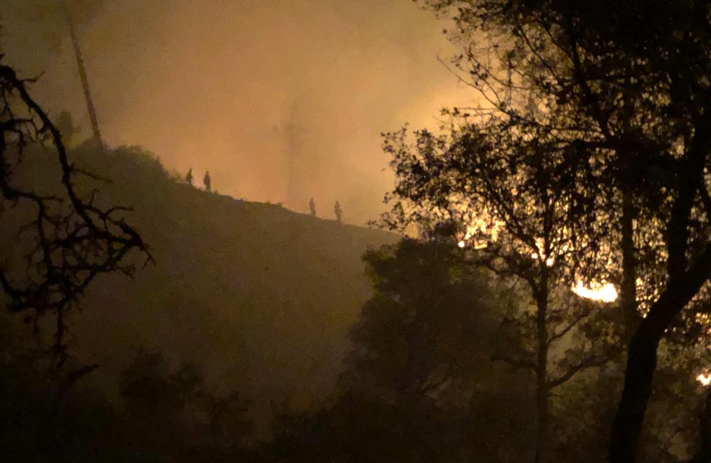
Firefighters monitor the Camp Fire in Northern California. Inciweb photo.

A Mississippi State University civil engineering faculty member who researches resilience against extreme events and natural hazards is responding to lessons learned from California’s deadly Camp Fire by outlining how to utilize the power of data to improve disaster response and minimize economic loss and human harm in similar events.

In a letter published January 10, 2019 in Science Magazine, Farshid Vahedifard writes that in the aftermath of the Camp Fire in Northern California, it is critical to examine how decision makers and first-responders can “prevent an extreme hazard like the Camp Fire from turning into a massive human disaster.”

Vahedifard is an MSU Bagley College of Engineering associate professor who also holds the Civil and Environmental Advisory Board Endowed Professorship. He penned the Science letter with MSU colleague Alireza Ermagun, assistant professor of civil and environmental engineering; Kimia Mortezaei, an MSU engineering postdoctoral associate with the university’s Center for Advanced Vehicular Systems; and Amir AghaKouchak, a University of California-Irvine associate professor of civil and environmental engineering.

With reports pointing to shortcomings in disseminating critical information to warn residents before and during the November fire that killed 85 people, scorched more than 153,336 acres and destroyed more than 18,800 structures, the authors point out that a “lack of an integrated framework for circulating information among decision-makers and passing it to residents exacerbated the devastating impact of the wildfire.”

They assert that investment in an integrated system for identifying, harnessing, synthesizing, and communicating pertinent data would “enable decision-makers and communities to better anticipate, prepare for, respond to and recover from extreme events such as the Camp Fire.”

They continue, “We must identify relevant stakeholders, examine the required data, collect public and relevant private data efficiently, and develop platforms for processing datasets such as weather data, cell phone GPS data as proxy for people, social media feeds, and traffic cameras and sensors. We then need strategies to convert data sets into usable information by using artificial intelligence technologies for decision-support systems. To communicate the resulting information effectively, we need a reliable data infrastructure for real-time analysis that could alert residents by email, phone messages, text warning, television, radio, and ‘reverse 911.’”

Vahedifard and colleagues previously have published research and commentary highlighting how a chain of events, such as wildfires, landslides and mudslides, cascades like a series of toppling dominoes and leads to catastrophic disasters.

Facing liability over wildfires, PG&E to file for bankruptcy

The company may have $30 billion in potential liability costs related to their role in starting wildfires

PG&E service territory
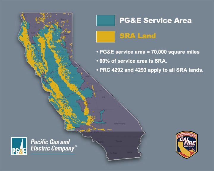
Map showing the service area of Pacific Gas & Electric, and the land protected by CAL FIRE (State Responsibility Area).

Pacific Gas and Electric has announced that it will file for Chapter 11 protection before the end of the month as it faces $30 billion in potential liability costs related to their role in starting wildfires. The company already carries a heavy debt load of more than $18 billion.

A dozen of the fires that started in Northern California around October 8, 2017 have been blamed on PG&E’s electrical equipment, according to CAL FIRE investigators, who also are looking into power line equipment failures that may have caused the Camp Fire on November 8, 2018. Over 40 people died in the Northern California fires, and 86 perished in the Camp Fire which also destroyed more than 14,000 homes.

The bankruptcy process would put a halt to more than 750 civil suits brought by thousands of homeowners and insurance companies over the wildfires allegedly caused by PG&E’s equipment, some of it 100 years old. The suits would then be resolved in a bankruptcy proceeding.

PG&E supplies power and natural gas to approximately 5.2 million households in the northern three-fourths of California. The company also declared bankruptcy in 2001 which lasted until 2004.

State law requires the corporation to notify employees at least 15 days before any bankruptcy filing. Chief Executive Geisha Williams has stepped down after serving for less than two years, the company said on Sunday.

In a brief submitted to a federal court in December, the California Attorney General said PG&E could be prosecuted for murder, manslaughter, or lesser criminal charges if investigators determine that “reckless operation” of its power equipment caused any of the wildfires in which people were killed during the previous 15 months.

Thousands told to evacuate below burn scars in Santa Barbara area as heavy rain is predicted

The evacuation order begins at 10 a.m. January 15

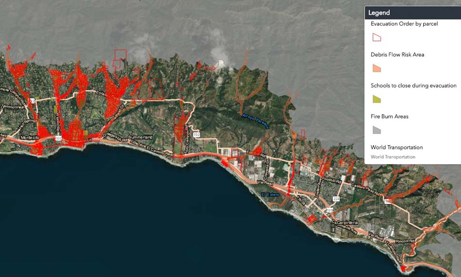
Fire debris flow flooding Santa Barbara evacuation map
Map showing areas under evacuation orders beginning at 10 a.m. January 15, 2019. Santa Barbara County. Click to enlarge.

Three to four thousand residents in areas below the footprints of three recent fires in Southern California’s Santa Barbara County have been ordered to evacuate as a winter storm approaches which could lead to debris flows below the Sherpa, Whittier, and Thomas fires burn areas. The evacuation order is in effect beginning at 10 a.m. Tuesday January 15.

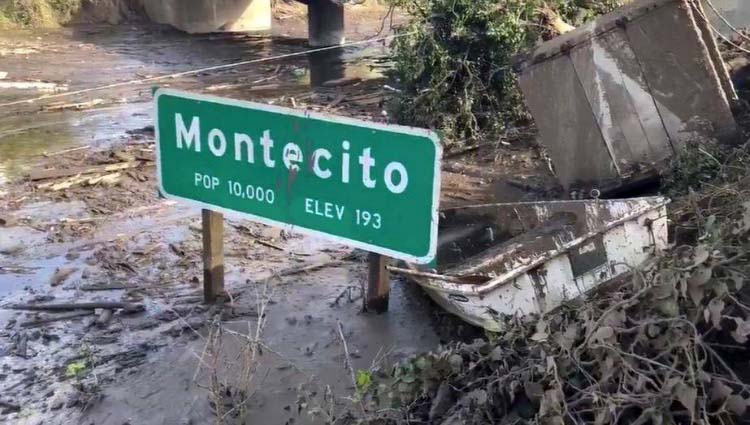
Thomas Fire debris flow flooding
Mud and debris flow in Montecito below the Thomas Fire, January 9, 2018. Photo by Mike Eliason, Santa Barbara FD.

Santa Barbara County has more information about the evacuation, including a map. A Red Cross shelter will be open at 10 a.m. at Goleta Valley Community Center, 5679 Hollister Ave., Goleta. Two schools are closed and three are holding classes at alternative sites.

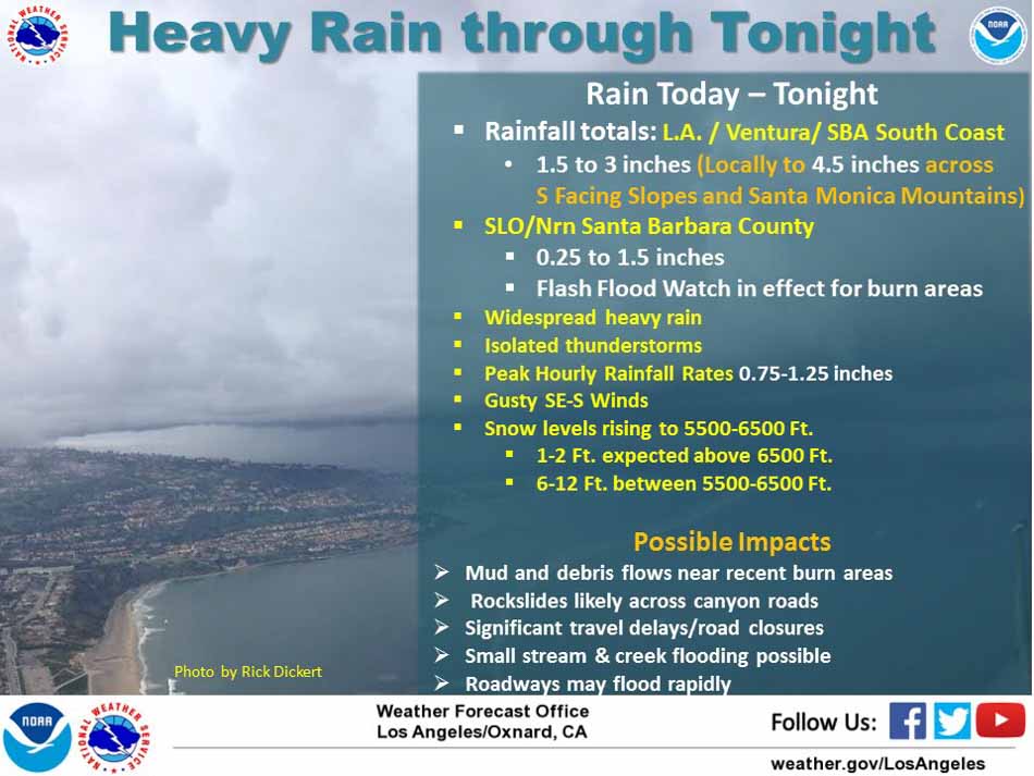
The National Weather Service is predicting 1.5 to 3 inches of rain in the Santa Barbara area with up to 4.5 inches locally on south-facing slopes. Peak hourly rainfall rates could reach 0.75 to 1.25 inches. The heavy rain should taper off Tuesday night, followed by showers on Wednesday which will increase to heavy rain again Wednesday night.

Fire debris flow flooding Santa Barbara

Initial attack on Woolsey Fire was hampered by shortage of resources

The quickly spreading Hill Fire started 21 minutes before, 15 miles to the west

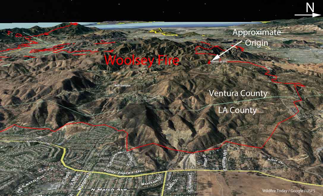
3D Map Woolsey Fire Ventura County Los Angeles d-D
3-D Map of the Woolsey Fire. The red line was the perimeter. Click to enlarge.

No wildfire starts at the right time, but the fire that Los Angeles County describes as the worst in the county’s modern history began at a particularly bad time. The Woolsey Fire was reported on November 8, 2018 21 minutes after the Hill Fire about 15 miles to the west. Both began in Ventura County in Southern California while strong Santa Ana winds were blowing out of the north and northeast. The Camp Fire which started about 8 hours earlier in Northern California had already destroyed thousands of homes in the Paradise area.

The incident commanders decided that the Hill Fire had the greatest immediate potential to affect lives and property — there were fewer homes close to the point of origin of the Woolsey Fire.

Progression map Woolsey Fire
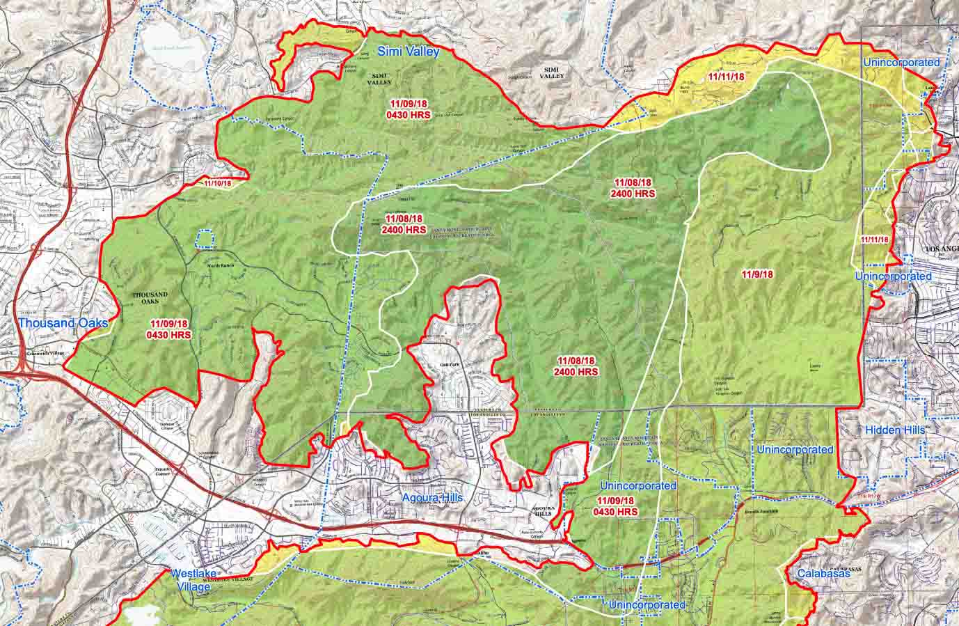
Progression map of the north side of the Woolsey Fire, prepared by the Incident Management Team. Click to enlarge.

With resources flooding in to the Hill Fire, the first unit to arrive at the Woolsey fire got there almost 20 minutes after it was reported. In a densely populated part of the country where it is common to have hundreds of engines on a rapidly spreading wildfire within hours, after 60 minutes only 11 engines were on scene.

About 12 minutes after it was reported, the quickly growing Hill Fire jumped the 101 Freeway but 2 hours later it hit an area that had burned in 2013 and slowed, allowing firefighters to make significant progress. By midnight the incident commander shifted some resources over to the Woolsey Fire which had spread to Agoura Hills.

By 4 a.m. on November 9 pushed by increasing winds gusting to 70 mph, the Woolsey Fire crossed the 101 Freeway and at the end of the day had spread to the Pacific Ocean, 20 miles from where it started a little more than 24 hours before.

Map Woolsey Fire Ventura County Los Angeles
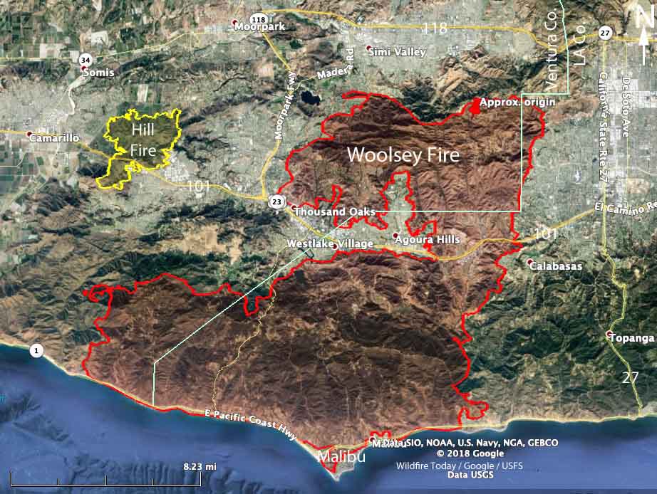
Map of the Woolsey and Hill Fires.

Stats: Hill Fire / Woolsey Fire

  • Acres: 4,500 / 97,000
  • Structures destroyed: 4 / 1,500
  • Fatalities: 0 / 3
  • Length (miles): 4 / 20

The Hill Fire had far more firefighting resources assigned during the first six hours, compared to the Woolsey Fire which was starved of engines and aircraft during that period. But the Hill Fire spread into a previous burn and slowed which made the firefighters’ jobs easier.

Below are excerpts from an article in the Los Angeles Times about the fire.

…Veteran firefighters say it was a once-in-a-lifetime event.

“In my 30 years of experience, I’ve never seen a fire that explosive,” [Los Angeles Fire Department Deputy Chief Trevor]  Richmond said. “Seeing how quickly that fire traveled to Agoura Hills and Oak Park and Thousand Oaks and jumped the freeway the next morning, and in four hours, it’s burning kelp beds in the Pacific Ocean — that’s pretty incredible.

“This one was the big one,” he said.

[…]

[Ventura County Fire Assistant Chief Dustin] Gardner said he was repeatedly on the phone begging the state to send more tankers to Ventura County, arguing the Woolsey fire had the potential to hit Malibu, not realizing how bad the Camp fire had become. Within the first hour of the Hill fire, the incident commander doubled his order from four to eight air tankers.

Soon after, a dispatcher asked him if they could divert one of his fire’s tankers to the Woolsey fire, which was potentially going to threaten homes and businesses in Simi Valley.

“You can divert one of the air tankers,” Ventura County Fire Assistant Chief Chad Cook, the Hill fire incident commander, said. “We’ll keep the rest of them here.”

About 40 minutes later, at 3:37 p.m., a dispatcher told the Hill fire incident commander two air tankers and two helitankers would soon arrive to fight the blaze. Only a few minutes later, the Woolsey incident commander was told by a dispatcher that the region had no more air tankers it could send, but that there were multiple helicopters available.

About an hour later, the Woolsey incident commander seemed to be frustrated by his tanker requests going unfilled.

“I’d like to talk to my neighboring fire (commander) and see if I can get some from him,” the Woolsey incident commander told his aerial coordinator over the radio at 4:26 p.m.

“Correct, sir,” the aerial coordinator said. “We’ve been trying to negotiate resource sharing. We’ll see how that goes.”

But the Woolsey fire began spreading at a much faster pace — with far fewer firefighters on the ground than were battling the Hill fire…

Thanks and a tip of the hat go out to Tom.
Typos or errors, report them HERE.

Report: CAL FIRE prevented insurance company fire engines from accessing customers’ homes during Woolsey Fire

Satellite photo smoke Woolsey Fire
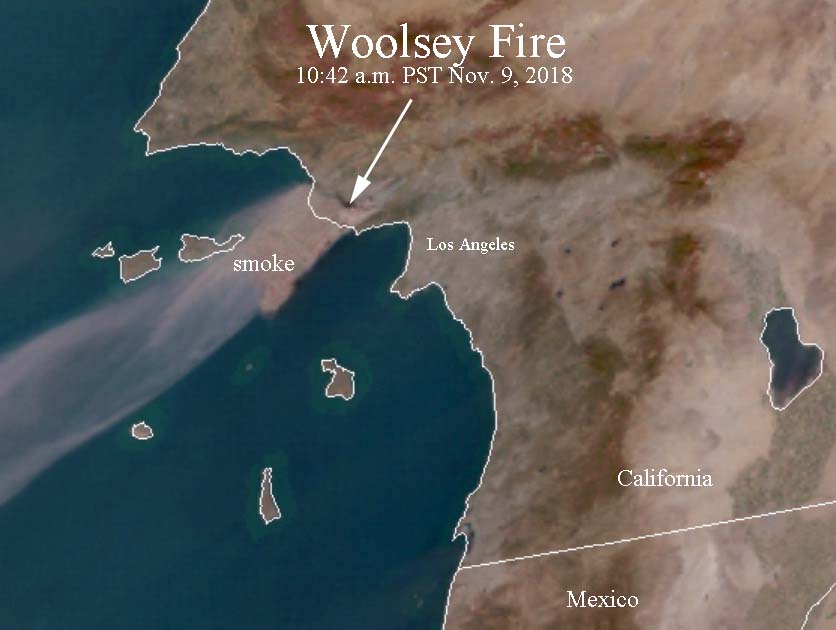
Satellite photo showing smoke from the Woolsey Fire at 10:42 a.m. PST November 9, 2018. Click to enlarge.

For the last 12 years we have been aware of insurance companies sending fire engines to protect high-valued homes covered by their policies when a wildfire approaches. Companies such as Chubb figure keeping a multi-million dollar home from burning is less expensive than paying to rebuild it, so they contract with Wildfire Defense and other companies to send firefighters to their customers properties when smoke is in the air.

The tricky part is intermixing the private crews with the existing incident management organization. Some jurisdictions view the insurance company crews as personnel that need to be protected, rather than fellow firefighters engaged in the fire fight. This became very evident during the Woolsey Fire in November when CAL FIRE prohibited the private engine crews from accessing their customers’ homes, including mansions in Malibu, California.

Below is an excerpt from the Malibu Times:

…While benefits seem obvious for insurance companies, statewide fire officials point out they complicate firefighting efforts for central command, since they cannot communicate readily with rank-and-file crews. Now, in the fallout of the Woolsey Fire—where resources were spread so thin many homes did not see any fire engines at all—questions are being asked about why private crews were turned away.

Malibu resident Ron Krisel, who is insured by USAA (only available to active, retired and honorably discharged members of the U.S. military), was eligible for the services of a private firefighting crew. However, he was notified by USAA that when their crew checked in with the joint command for the Woolsey Fire, they were told by CAL FIRE that they would not be allowed to come into Malibu and, something to the effect that, if they disobeyed, they would never be allowed in during a fire from now on.

Krisel’s house burned down the day after the fire came through—a casualty of still-blowing embers. He feels strongly that if the private crew contracted by USAA had been allowed to come in, his house would’ve been saved—they would’ve kept an eye on the burning embers and hot spots and put them out before the house caught fire. County firefighters never showed up.

When The Malibu Times contacted Scott McLean, public information officer for CAL FIRE Woolsey Fire, to ask why, he said he wasn’t familiar with this particular incident, and would only be able to talk about their policy in general.

McLean verified that private fire companies must check in with the authorities at the joint command to show documentation from the insurance company and the address of the specific house.

“It’s a common thing—no big deal. We rarely turn them away,” McLean said. “But if there’s an evacuation order for the area the house is in, they cannot come in.” That’s the most obvious reason why the crew coming to Krisel’s house was turned away—the Malibu evacuation order must have already been in effect.

Our opinion:

Private engine crews can be helpful in keeping certain high-value structures from burning during a rapidly spreading wildfire when there are not enough government resources to protect every home. However, if they have no communication with the incident management organization which does not have any knowledge of their location, mission, or capabilities, it can throw a monkey wrench into an already chaotic situation.

CAL FIRE, the U.S. Forest Service, and the other large organizations involved in wildfire suppression need to sit down with the insurance companies and agree on some standard operating procedures. The Incident Management Team needs to know what the private crews are doing and where, and the private crews need to have direct communication with the Team.

One day, when all firefighting resources are carrying equipment that makes it possible to track their location, this will become much easier — and safer. The federal and state agencies need to get off their butts and implement these tracking systems.

Wildfires: Attorney General says PG&E could face murder charges

Depends on which charges, if any, are filed by county district attorneys for causing wildfires in 2017 and 2018

In a brief submitted to a federal court, the California Attorney General wrote that Pacific Gas & Electric could be prosecuted for murder, manslaughter or lesser criminal charges if investigators determine that “reckless operation” of its power equipment caused any of the wildfires in which people were killed during the last 15 months.

Gavel

A dozen of the fires that started in Northern California around October 8, 2017 have been blamed on PG&E’s electrical equipment, according to CAL FIRE Investigators, who also are looking into power line equipment failures that may have caused the Camp Fire on November 8, 2018. Over 40 people died in the Northern California fires, and 86 perished in the Camp Fire. More than 14,000 homes were destroyed in the Camp Fire.

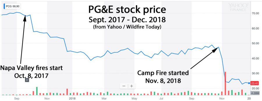
Shortly after both events the stock price of PG&E dropped precipitously, sinking 66 percent over the 13-month period. It took several days in 2017 for word to spread that the company appeared to be liable for the Northern California fires, but the sell-off began the day after the Camp Fire started in 2018. Investors are worried that the utility could be on the hook for billions of dollars in civil damages in addition to criminal penalties.

Stock price PG&E california fires wildfires liable

Below is an excerpt from the Sacramento Bee:

The legal brief submitted by [Attorney General Xavier] Becerra’s office said prosecutors would have to gauge PG&E’s “mental state” before determining which charges, if any, to bring. The charges would range from murder to a misdemeanor negligence charge, according to the brief. Becerra’s brief is purely advisory; if any criminal charges are filed, they would likely be lodged by county district attorneys, not the state.
So far, though, district attorneys have shown little appetite for prosecuting PG&E, according to Sacramento Bee reporting. No charges have been filed yet in the wine country fires. And at least one DA has opted for a financial settlement in lieu of criminal prosecution