128 active wildfires in British Columbia as firefighters from North America and Australia arrive to help

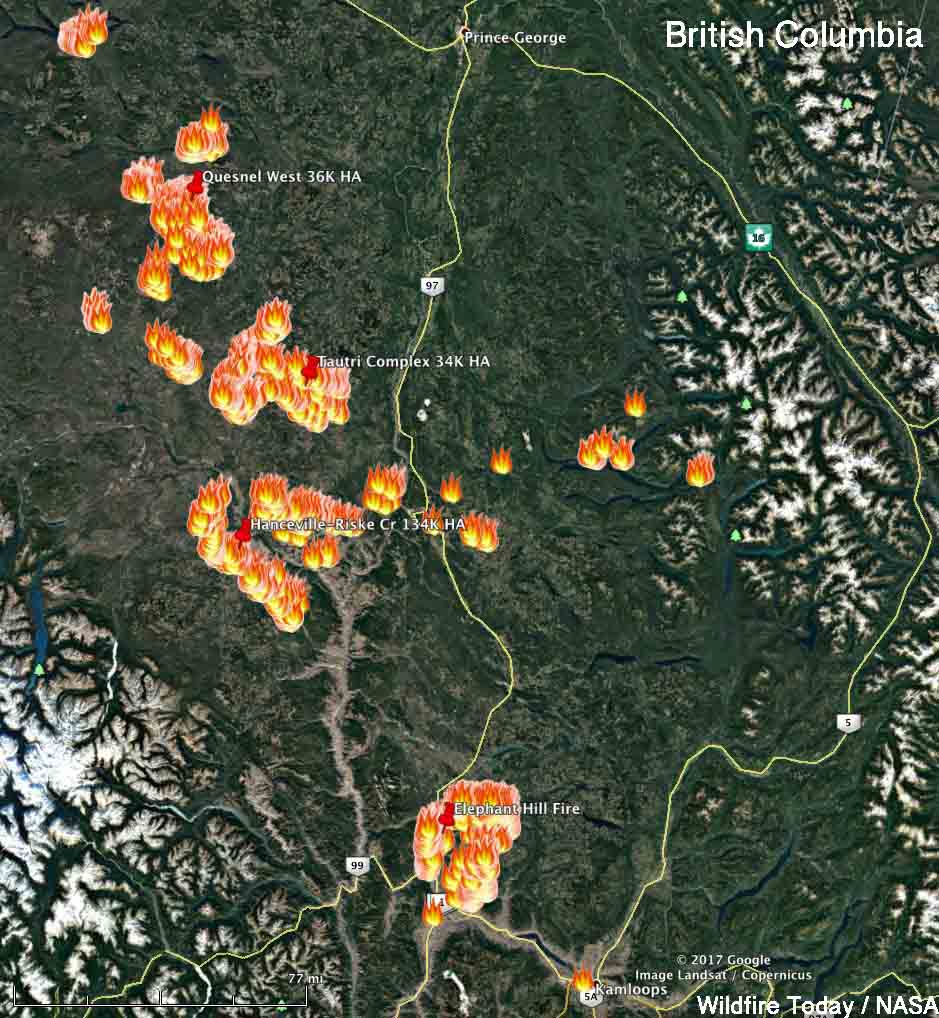
Above: Map showing heat detected by a satellite in southern British Columbia at 2:51 a.m. MDT August 9, 2017.

(Updated at 5 p.m. MDT August 9, 2017)

The wildfire situation in British Columbia has not gotten any better in the last several days. Currently there are 128 active wildfires in the province, with four of them being larger than 50,000 hectares (123,000 acres). The largest, the Hanceville Riske Creek Fire, is getting closer to half a million acres each day.

Since April 1, approximately 591,280 hectares (1,461,082 acres) have burned in 900 fires in BC.

  • Hanceville Riske Creek, 172,000 hectares (425,000 acres) approximately 60 km southwest of Williams Lake.
  • Elephant Hill, 117,000 hectares (289,000 acres), near Ashcroft.
  • Tautri Lake, 76,000 hectares (188,000 acres), 80 km northwest of Williams Lake.
  • Baezaeko River-Quesnel West, 53,000 hectares (131,000 acres).

More than 400 additional firefighters from Australia, New Zealand, Mexico and the US are expected to arrive in BC this week. Other firefighters from Australia have been in the province for a couple of weeks. More than 100 firefighters arrived from Mexico since Saturday of last week. No resources have been ordered or dispatched to Canada through the United States National Interagency Coordination Center, but   the Great Lakes Interstate Forest Fire Compact mobilized a crew to Ontario that is now in British Columbia, and Massachusetts sent personnel across the border. Of course the northwestern one-quarter of the United States is pretty busy with their own fires.

Massachusetts firefighters British Columbia
Firefighters from Massachusetts board an aircraft on the way to the Elephant Hill Fire near Ashcroft, British Columbia. Photo by Mass. Department of Conservation and Recreation.
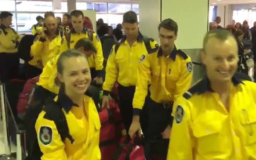
NSWRFS firefighters British Columbia
On Tuesday U.S. time 40 firefighters from Australia’s New South Wales Rural Fire Service joined 60 others from across the continent as they began their travel to British Columbia. Screenshot from NSWRFS video.

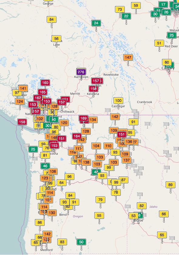
Smoke from wildfires in British Columbia, Washington, Oregon, Idaho, and Montana has created seriously degraded air quality off and on in those areas, at times reaching the “unhealthy” level according to air quality officials.
Air quality southern BC Washington Oregon
Air quality, southern BC, Washington, and Oregon.
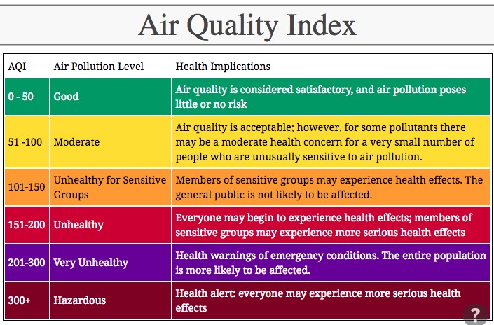
Air Quality map
Legend for the above Air Quality map.

Maps of wildfires and smoke in the U.S. Northwest and British Columbia

Above: Satellite photo showing wildfire smoke in the northwestern United States and British Columbia August 6, 2017. The red dots represent heat.

wildfire smoke map
Graphic representation of the distribution of wildfire smoke in the U.S. and Canada, August 6, 2017. Click to enlarge.

Wildfire smoke produces haze over much of British Columbia and the U.S. Northwest

Above: Satellite photo of smoke from wildfires in the U.S. Northwest and Southern British Columbia, August 5, 2017. The red dots represent heat detected by the satellite.

(Updated at 6:50 p.m. MDT August 5, 2017 to add the more current satellite photo above.)

Smoke from wildfires in Southern British Columbia continues to pour across the border into Washington and other states in the U.S. Northwest. The air quality in Washington is the worst that residents have seen in recent years, reaching unhealthy levels in some areas according to agencies that monitor particulates and other pollutants.

Currently there are 110 active wildfires in British Columbia — four of them are larger than 50,000 hectares (123,000 acres):

  • Hanceville Riske Creek, 148,000 hectares (365,000 acres) approximately 60 km southwest of Williams Lake.
  • Elephant Hill, 110,000 hectares (272,000 acres), near Ashcroft.
  • Tautri Lake, 73,000 hectares (180,000 acres), 80 km northwest of Williams Lake.
  • Baezaeko River-Quesnel West, 55,000 hectares (135,000 acres).

Below is a gallery of maps and graphics showing the location of the fires, air quality, and smoke. Click on an image to see a larger version and start a slide show. Captions are in the top-left corner.

Over 100 active wildfires in British Columbia

Above: Satellite photo taken August 2, 2017 showing smoke from some of the wildfires in British Columbia. The red dots represent heat detected by a sensor on the satellite

(Originally published at 9:50 p.m. MDT August 2, 2017)

Firefighters in British Columbia are dealing with over 100 wildfires that are larger than 0.01 hectare. The location for four of the largest can be seen on the map below which shows heat detected by a satellite on Wednesday.

map fires in British Columbia
Map showing heat from fires in British Columbia detected by a satellite at 3:12 p.m. MDT August 2, 2017. Click to enlarge.

Here are very brief of summaries of four of the largest fires:

  • Hanceville-Riske Creek, 60 kilometers southwest of Williams Lake. The Hanceville and the Riske Creek Fires are being managed as one. Together they have burned 134,000 hectares (331,000 acres).
  • Quesnel West, 4 km north of the Baezaeko River. 36,000 HA (88,000 acres).
  • Tautri Complex, 85 km northwest of Williams Lake. 64,000 HA (84,000 acres).
  • Elephant Hill, near Ashcroft. 84,000 HA. (207,000 acres).

The weather forecast for Ashcroft near the Elephant Hill fire looks grim for firefighters —  over 100F every day for the next week with the relative humidity around 20 percent or below. It looks better for Williams Lake with highs in the high 80’s and low 90’s with the relative humidity in the mid-20’s.

Elephant Hill Fire in British Columbia grows to 194,000 acres

The fire has been burning near Cache Creek, BC since July 6, 2017.

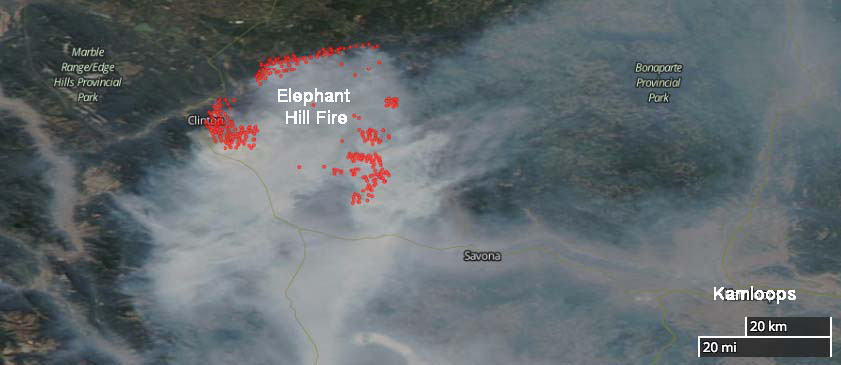
Above: Satellite photo showing the location wildfires in British Columbia and Alberta, July 31, 2017. The red dots represent heat detected by the satellite.

(Originally published at 7:32 p.m. MDT July 31, 2017)

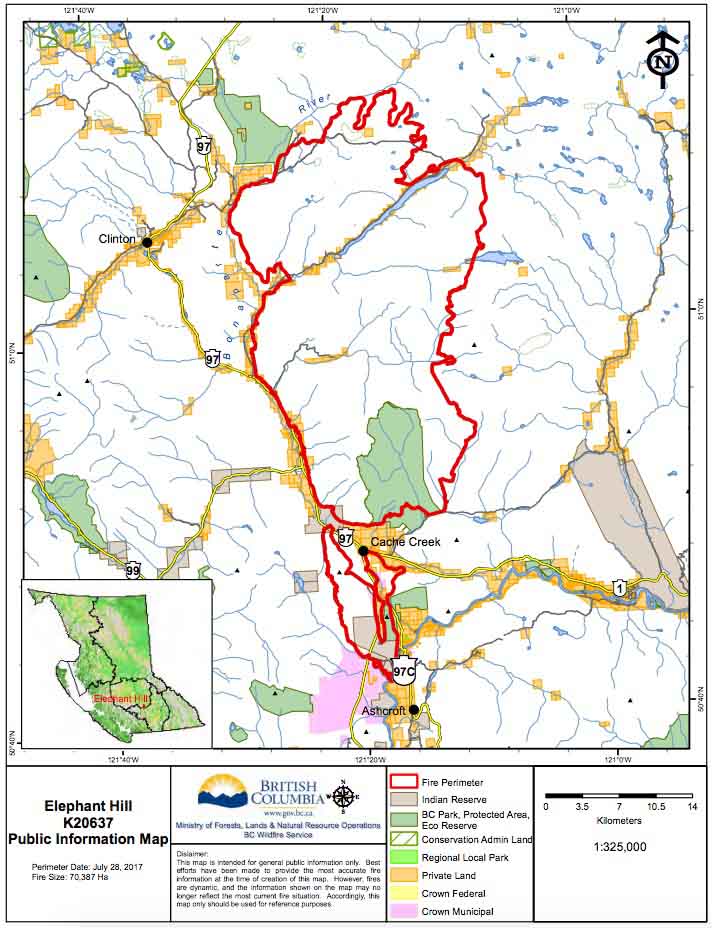
Currently there are many wildfires burning in British Columbia and Alberta. One of them is a megafire just east of Clinton, north and south of Cache Creek, and about 50 miles northwest of Kamloops. I’m not sure if it’s the Mother of All Fires, for this year anyway, but so far it has covered 78,548 hectares (194,096 acres). The BC Wildfire Service says that number is probably low, since the visibility has prevented them from conducting mapping flights for a day or two.

(More recent information about the Elephant Hill Fire and other fires in British Columbia was posted August 2, 2017.)

The recent warmer and drier weather has contributed to increased growth in recent days. On Sunday most of the spread was on the north and west sides.  The objective on the west flank is to remove excess fuel ahead of the fire, keep it south of the Bonaparte River, and slow the aggressive fire behavior. Night shift crews are working from 8 p.m. to 8 a.m. to reinforce firelines.

Structure protection personnel, engines, and equipment are assigned 24 hours a day. They are working across the fire to conduct property assessments, establish sprinkler systems on structures, and protect values where needed.

Elephant Hill Fire map
Satellite photo showing smoke on the Elephant Hill Fire northwest of Kamloops, July 31, 2017. The red dots represent heat detected by the satellite.

The community of Clinton and areas to the northeast including Green Lake have been evacuated.

Resources assigned to the fire include 20 helicopters and 69 pieces of heavy equipment for a total of 359 firefighters.

The map below was current July 28, 2017.

Elephant fire map

1 in 5 firefighters on 2016 Fort McMurray Fire suffered from respiratory problems

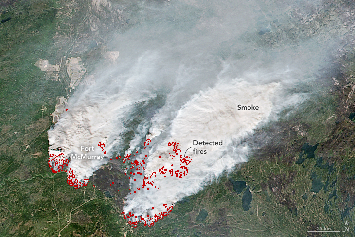
Fort McMurray fire, May 16
Fort McMurray fire, May 16, 2016. NASA.

Some firefighters who fought the 1,500,000-acre Fort McMurray Fire that burned 2,400 homes in Alberta last year also battled respiratory and mental health issues.

Below is an excerpt from a CBC news article:

The University of Alberta study surveyed 355 firefighters and found a “very large proportion” of them complained of respiratory issues including coughing, breathlessness, wheezing and chest tightness in the immediate aftermath of the fire.

“When we saw them later, probably about one in five of those still had problems with their chests that they felt had been caused or made worse by the fire,” said Nicola Cherry, the epidemiologist leading the study.

And they’re battling more than just physical ailments — mental-health issues affect one in six of study participants.

“When we collected this information, it was early days and people may develop bigger issues as time goes forward,” Cherry said.

****

Articles on Wildfire Today tagged Fort McMurray Fire.