Structures lost as Spring Creek Fire in southern Colorado burns 4,000 acres

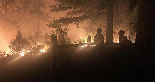
The Spring Creek Fire in Costilla County, Colorado. Photo courtesy Colorado Division of Homeland Security and Emergency Management Field Manager via San Luis Valley Twitter.

(UPDATED at 8:51 a.m. MDT June 29 2018 by Bill Gabbert)

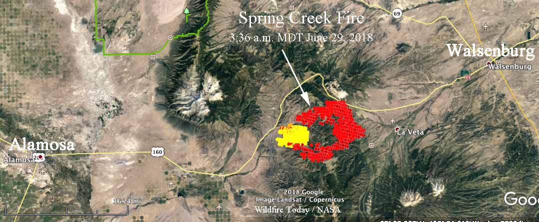
Updated information provided by the Rocky Mountain Coordination Center reported that the Spring Creek Fire has burned 14,424 acres. However infrared data from a fixed wing aircraft that flew the fire at 9:35 p.m MDT on June 28 showed that the fire was significantly larger. The convection column of smoke made it difficult for the equipment to map accurately as it avoided plumes and bounced around. Other information collected by a satellite at 3:36 a.m. also showed that the fire was very active on the east and southeast sides and that it could be much larger as than the last official estimate by the RMCC.

CLICK HERE to see all of the articles on Wildfire Today about the Spring Creek Fire.

There are reports that the fire has crossed and required the closure of Highway 160, the main highway between Walsenburg and Alamosa.

The early information was that the name of the fire was “Spring”, but the official name is “Spring Creek”
Spring Creek Fire
Map showing heat detected by a satellite over the Spring Creek Fire 3:36 a.m. MDT June 29. The data may not be as accurate as desired due to the intensity of the plume. It is possible that the hole in the middle of the fire burned and cooled before the overflight.

Shane Greer’s Type 2 Incident Management Team was scheduled to assume command at 6 a.m. on June 29.

The area is under a Red Flag Warning on Friday, bringing a high potential for rapid spread. Thursday the fire was exhibiting extreme fire behavior with running, torching, crowning and spotting a quarter of a mile ahead. Evacuations  were in progress and multiple residences are threatened.


(Originally published at 11:01 a.m. MDT June 28, 2018 by Jason Pohl)

A wind-driven wildfire in Red Flag conditions blackened an estimated 4,000 acres by Thursday night in southern Colorado, officials said.

The Spring Creek Fire is burning between Walsenburg and Fort Garland in Costilla County, not far from the New Mexico border.  While officials have said structures were damaged and destroyed since the fire started Wednesday, it was not immediately clear how extensive the devastation was.

According to The Denver Post:

“There have been structures lost,” said Linda Smith, spokeswoman for the San Luis Valley Emergency Operations Center. “I do not know whether they were homes. I do know there are a lot of homes in that area.”

Officials declared a disaster for the area Wednesday night.

The cause of the fire is under investigation.

A Red Flag Warning is in place for Friday as much of the region continues to experience record high temperatures.

Incident Commander on the 416 Fire interviewed as the team’s assignment ends

Since the fire started June 1 about 10 miles north of Durango, CO., it has burned over 34,000 acres west of Highway 550

Above: An undated photo of the 416 Fire, from Inciweb.

After being assigned to the 416 Fire for two weeks Todd Pechota’s Type 1 Incident Management Team will demobilize Friday morning and transition to Joe Reinarz’s National Incident Management Organization (NIMO) team. Mr. Pechota is the Forest Fire Management Officer on the Black Hills National Forest but is currently detailed into his former bosses job which is vacant, the Forest Supervisor position.

File photo of Forest FMO Todd Pechota on a prescribed fire in 2016. Screen grab from a video by Bill Gabbert.

As Mr. Pechota’s time on the 416 Fire wound down, Alex Semadeni, a writer for the Durango Herald, interviewed the Incident Commander.

Below is an excerpt:

“We were playing a bit of a tough hand based on weather and topography and fuels,” Pechota said. “In many, many places of the fire, we just couldn’t land on a place where being able to take care of them (firefighters) in the event of an injury was an acceptable risk.”

Pechota was also concerned about the fire’s proximity to homes and the city of Durango in general. The fact that the fire was across the highway from the 2002 Missionary Ridge Fire wasn’t lost on him either.

“It’s kind of eerie,” he said. “If you’re a student of fire, you would look across the road and see the burn scar of Missionary Ridge. And what is the thing about Missionary Ridge that people remember? Some people it may have been the flooding. Some people it may have been the size. Some people it may have been the huge fire whirl that went across Vallecito. But many of us, the thing that we remember is that somebody died fighting the fire.

“That’s one of those things that when you’re asking young men and women to go engage a fire that you look right across the road and there is the burn scar from an event that took somebody’s life. It heightens our awareness, it heightens our sensitivity of operations, all those kind of things.”

416 Fire chinook helicopter
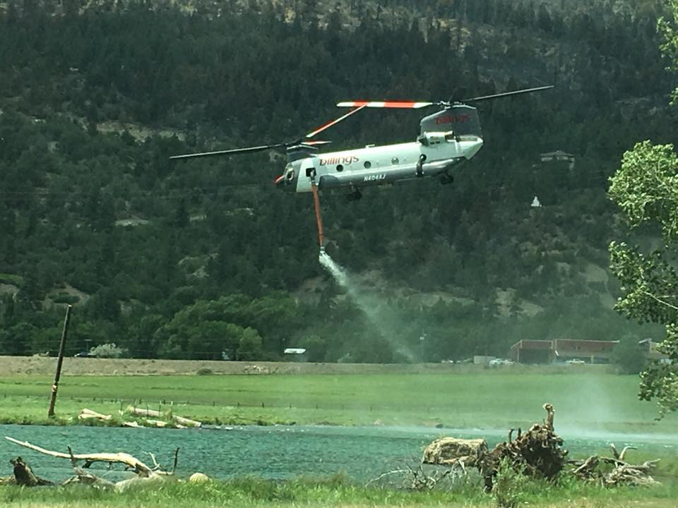
A Billings Helicopters Chinook departs from a water source after refilling their new internal water tank to help suppress the 416 Fire.

Weather slows fire activity in Western United States

Above: Accumulated precipitation over the last seven days, June 12-18, 2018. 

Moderating weather over the last seven days has helped firefighters make progress on some of the fires in Colorado, Wyoming, New Mexico, and Utah. Today’s national Situation Report showed little or no increase in the size of wildfires in those four states. The 416 Fire in southwest Colorado and the Badger Creek Fire in southern Wyoming released a total of 345 personnel over the last 24 hours.

Todd Pechota’s Type 1 Incident Management Team is currently assigned to the 416 Fire, but Joe Reinarz’s NIMO team has been mobilized for the fire, which could be an indication that they expect it to be a long term incident. The west side of the fire has spread into steep, remote terrain above 8,000 feet as it grows closer to an 11,000 to 12,000-foot ridge five miles away. Much of the ridge is above the timber line and may eventually, with patience over time, serve as a barrier. Mr. Reinarz’s team team will transition on Friday.

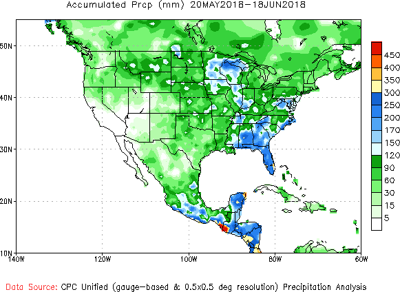
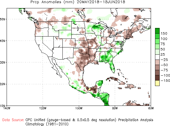
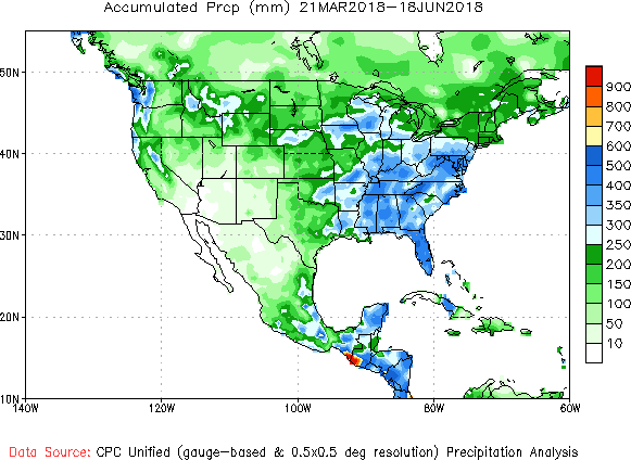
Below, National Weather Service graphics show the observed precipitation and the departure from normal for the last 30 and 90 days.

precipitation 30 days
Accumulated precipitation, May 20 through June 18, 2018. NWS.
precipitation 30 days
Precipitation departure from average, May 20 through June 18, 2018. NWS.
precipitation 90 days
Accumulated precipitation March 21 through June 18, 2018. NWS.
precipitation 90 days
Precipitation departure from average, March 21 through June 18, 2018. NWS.

Buffalo Mountain Fire causes evacuations near Silverthorne, Colo.

Above: The red dots represent heat detected by a satellite at the Buffalo Mountain Fire near Silverthorne, Colorado at 1:39 p.m. MDT June 12, 2018

(Originally published at 4:03 p.m. MDT June 12, 2018)

The Buffalo Mountain Fire started today, June 12, on the west side of Silverthorne, Colorado north of Frisco near Buffalo Mountain. At about 6:30 p.m. the Forest Service announced that it had burned about 90 acres.

The name was changed from “Buffalo Fire” to “Buffalo Mountain Fire” Tuesday afternoon.

Approximately 1,400 homes are under evacuation orders, which are likely to remain in effect through Tuesday night at least.

The local District Ranger said at a community meeting that the fuel reduction projects they had been working on for years are paying off, helping to protect structures.

Fire north of Durango continues westward expansion

firefighters 416 fire colorado wildfire
Firefighters on the 416 Fire. Photo uploaded to Inciweb around June 9, 2018. Photographer unknown.

(UPDATED at 7:03 a.m. MDT June 13, 2018)

Most of the spread of the 416 Fire north of Durango, Colorado Tuesday and Tuesday night was on the west side where it continues to grow onto the higher slopes in terrain that becomes increasingly difficult for ground-based firefighters. The fire ate up about 1,500 acres to bring the total to 25,900 acres.

It was announced Tuesday night that  the evacuation order for residents in San Juan County will lift at 8 a.m. on June 13. Residents will need to present a Rapid Tag resident credentials to return. The residences in San Juan County will remain on pre-evacuation notice.

map 416 fire colorado wildfire
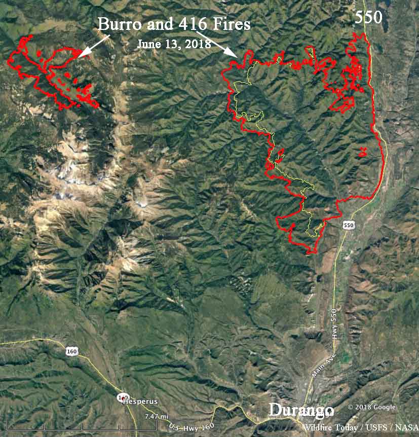
The red lines indicate the perimeters of the 416 and Burro Fires at 10:51 p.m. June 12, 2018. The yellow line was the perimeter about 24 hours before.

Resources on the 416 Fire include 9 Type 1 hand crews, 14 Type 2 hand crews, 55 engines, 3 dozers, and 4 water tenders for a total of 1,028 personnel. There are 203 personnel on the Burro Fire.

There was very little growth or activity on the Burro Fire Tuesday.

Fire management authorities are not releasing the cause of either fire.


(Originally published at 12:12 p.m. MDT June 12, 2018)

The wildfire with the odd name, “416”, continues to be very active especially on the west side. Over the past two days it has grown two miles closer to Durango, Colorado on the south side and is now seven miles from the north edge of the city, covering a total of 23,378 acres.

The west side of the 416 Fire has been the location of most of the activity recently where it has spread seven miles west of Highway 550 and to within six miles of another blaze, the 2,337-acre Burro Fire.

412 fire burro colorado wildfire
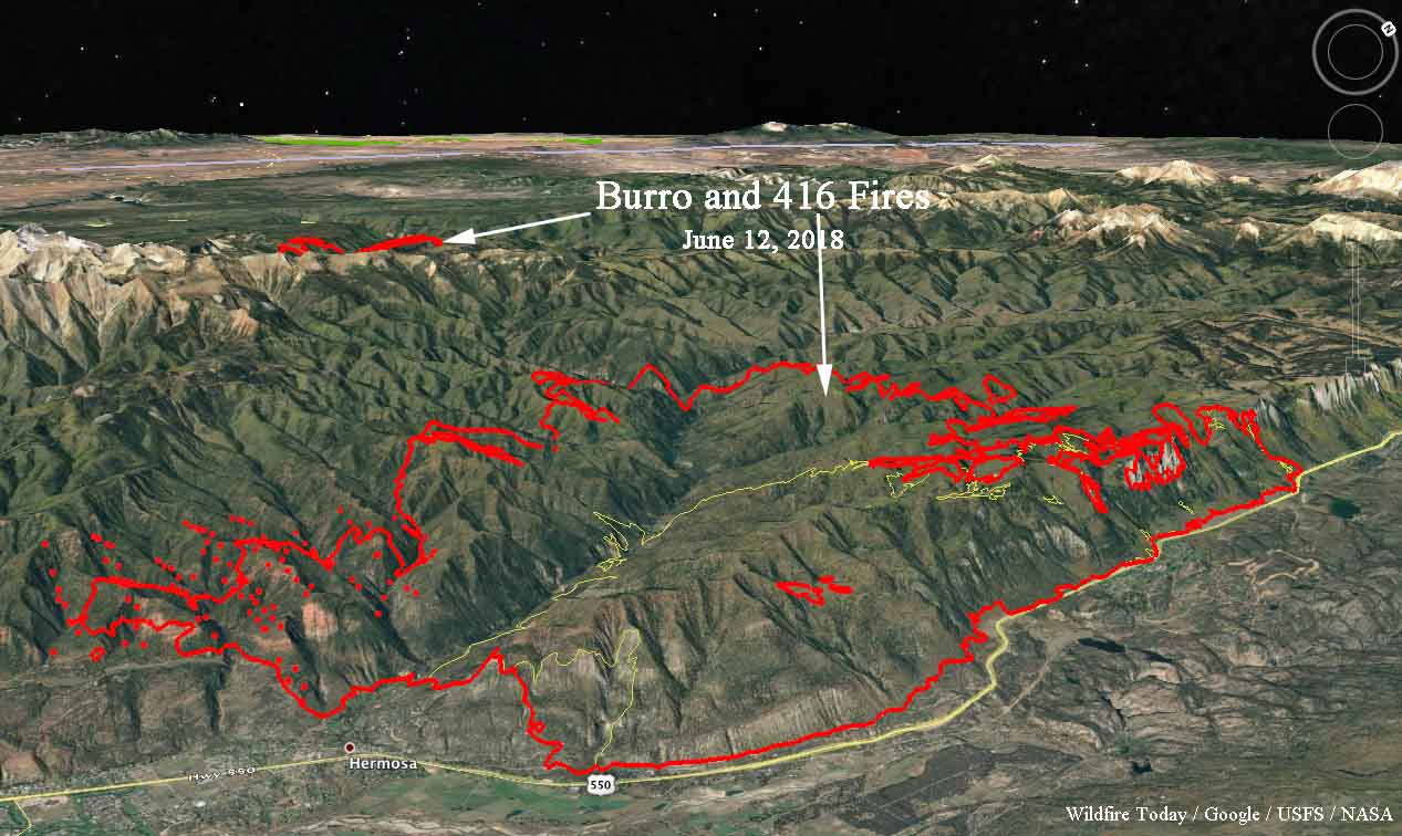
A 3-D map looking northwest showing the fires north and northwest of Durango, Colorado. The red line around the 416 Fire was the perimeter at 10:12 a.m. MDT June 11. The yellow line was the perimeter two days earlier. The red dots represent heat detected by a satellite at 2:13 a.m. June 12.

The west side of the 416 Fire is burning at over 8,000 feet in terrain that is difficult for ground resources. An 11,000 foot ridge separates the two fires and in normal times should serve as a barrier preventing them from merging, but the way wildfires have been behaving in recent years is anything but “normal”.

Todd Pechota’s Type 1 Incident Management Team is handling both fires.

The weather forecast for the fire area through Thursday calls for south and southwest winds of less than 10 mph, temperatures in the low 80’s, and 9 to 12 percent relative humidity. Beginning Thursday there is a chance of thunderstorms.

map burro fire 416 wildfires
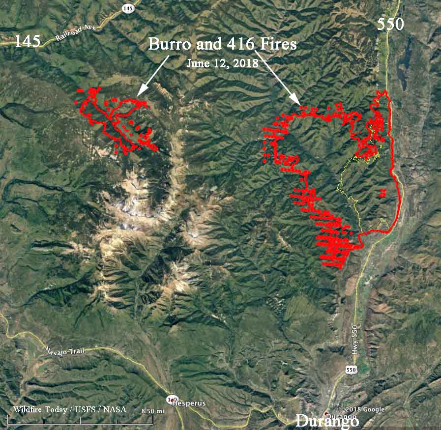
Map showing the fires north and northwest of Durango, Colorado. The red line around the 416 Fire was the perimeter at 10:12 p.m. MDT June 11. The yellow line was the perimeter two days earlier. The red dots represent heat detected by a satellite at 2:13 a.m. June 12.
trail mountain fire badger creek 416
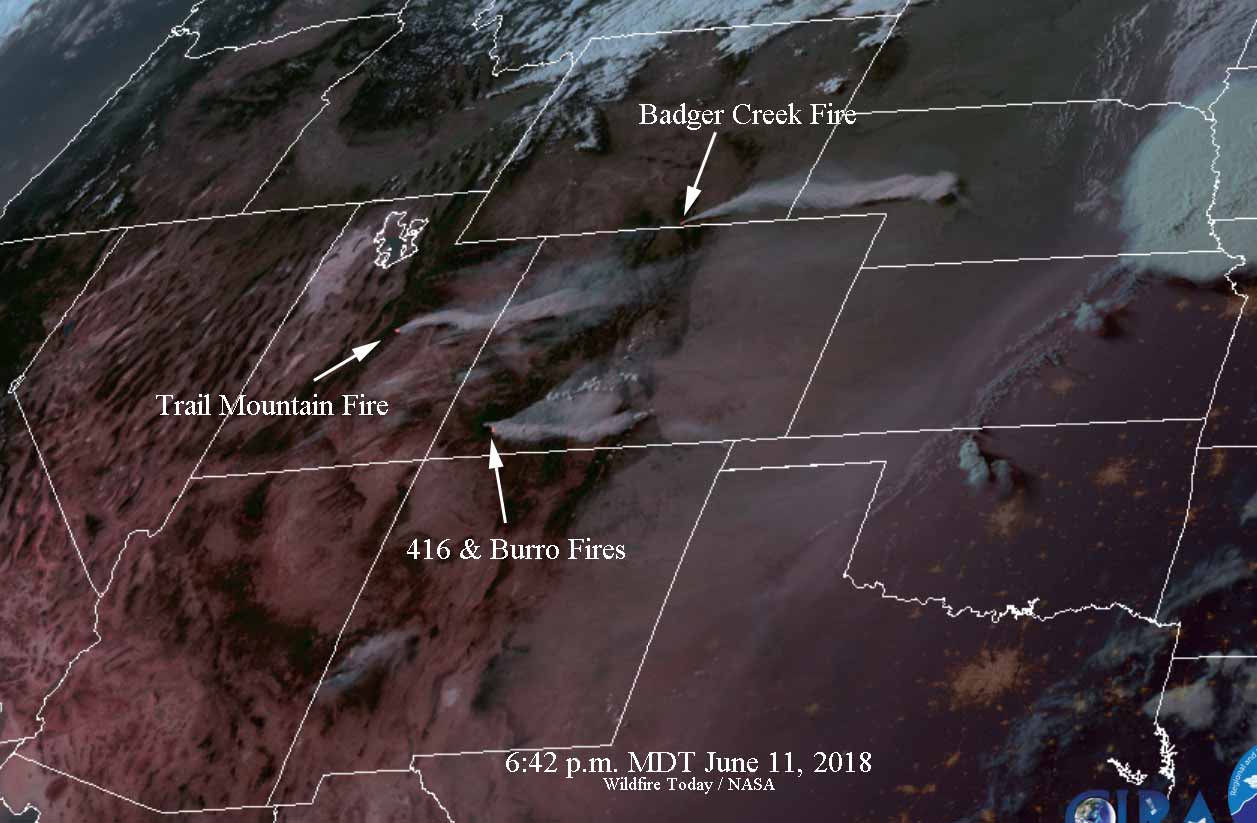
Satellite photo at 6:42 p.m. MDT June 11, 2018, showing the Trail Mountain Fire, Badger Creek Fire, and the 416 Fire.

Boco Fire burns over 400 acres near Eagle, Colorado

Above: The Boco Fire, shortly after it started June 9, 2018. Eagle County Sheriff’s Office photo.

The Boco Fire, one of two fires on Saturday in Eagle County, Colorado, quickly grew to over 400 acres in a few hours. It started 8 miles northeast of Eagle and was aggressively attacked as orders were placed for 5 Heavy Air Tankers, 1 Lead Plane, 1 Air Attack, 2 Single Engine Air Tankers, 1 Type 1 Helicopter, 1 Type 3 Helicopter, 1 Hotshot crew, and 1 Type 2 Initial Attack Crew. The aircraft assisted the firefighters on the ground who responded from several agencies.

Officials report Sunday morning that it has burned 415 acres. Most of Colorado was under a Red Flag Warning Saturday which is still in effect Sunday.

A few miles away a man shooting at exploding targets started another fire Saturday that was suppressed by firefighters while it was still fairly small.

Below is an excellent video of an air tanker drop on the fire by what appears to be an RJ85 air tanker (or possibly a BAe-146).

UPDATE #BoccoFire is now at 415 acres. Heavy suppression efforts are underway. Hwy 131 remains open this morning and may be closed this afternoon if necessary. pic.twitter.com/PwtgIqG3Lf