Air Tanker 861 (N803NZ) drops on the Oak Fire Dec. 27, 2021. Still image from West Metro Fire video.
Monday afternoon December 27 a fire southwest of Denver burned 152 acres and prompted evacuations.
The Oak Fire was reported around 2 p.m. southwest of Columbine, southwest of the C470 highway which was temporarily closed. West Metro Fire said it started near the C470/Kipling intersection west of the Westerly Apartments in an open space area with several trails and heavy foot traffic. The specific cause is still under investigation. The evacuations were cancelled Monday evening.
Oak Fire, on the southwest side of Denver, Dec. 27, 2021. Photo by West Metro Fire.
A single engine air tanker from CO Fire Aviation was mobilized from Fort Morgan, Colorado, flown by the company’s Chief Pilot Chris Doyle. It took off at 3:46 p.m. and 20 minutes later landed at Northern Colorado Regional Airport NCRA near Fort Collins to get a load of plain water which took about 10 minutes. It then made the 19-minute flight south to the fire where it quickly sized it up, dropped the water just before sunset, and returned to NCRA.
Flight path of Air Tanker 861 (N803NZ) while working the Oak Fire Dec. 27, 2021. FlightAware.
The fire was driven by strong winds. Buckley Air Force Base on the east side of Denver recorded 22 to 28 mph out of the south with gusts to 35 while the relative humidity was in the high 20s with the temperature in the high 30s. However it was cooler on the other side of the city at a higher elevation near the fire, judging from the ice photographed on the air tanker’s landing gear.
Ice on the landing gear of Air Tanker 861 after dropping water on the Oak Fire, Dec. 27, 2021. Photo by Chief Pilot Chris Doyle.
Firefighters always get a lot of satisfaction conducting a mobile attack, as seen in the videos below. An engine drives near the edge of the fire while one or two firefighters operate nozzles while walking, sometimes one in front of the engine and another picking up what’s left behind the truck. Or a second engine could followup, making sure all the heat near the edge is extinguished.
The #OakFire has slowed somewhat, but it’s still being driven by strong winds. There are no air resources available in the region. Neighboring fire districts are assisting on the ground. Two buildings at the Westerly Apts have been evacuated. 1/2 pic.twitter.com/XwmpxkR8cW
An MD-87 air tanker drops on the Blodgett Peak Fire Dec 22, 2021. Image from video shot by Colorado Springs Fire Department.
The last entry on the Pike & San Isabel National Forests blog was on October 13, about a 13-acre fire northeast of Gardner, Colorado — until yesterday, Dec. 22, when a fire was reported at 5:22 a.m. about two miles southwest of the Air Force Academy northwest of Colorado Springs. It was near the top of Blodgett Peak, 9,400 feet above sea level.
A person would think that three days before Christmas there would be snow in Colorado at that elevation, but none was visible in photos posted by the Colorado Springs Fire Department. And not only was there no snow, but two large air tankers were on duty and assisted firefighters.
The fire is 0.9 mile inside the National Forest boundary. It was mapped by the state’s multi-mission aircraft Wednesday at 0.3 acre.
Blodgett Peak Fire Dec 22, 2021. Photo by Colorado Springs Fire Department
The area was under a Red Flag Warning Wednesday for predicted winds gusting over 40 mph and very low humidity. Firefighters did not reach the fire Wednesday due to concerns about the wind. The area was patrolled by personnel from the Colorado Springs Fire Department that night, and the incident was turned over at 9 a.m. Thursday to the US Forest Service with a Type 2 hand crew and a Type 3 helicopter.
Ten years ago a slow moving fire on Colorado’s front range, especially in December, would not always have been aggressively attacked. But gradually since the 2012 Waldo Canyon Fire destroyed 344 homes, killed two people, and burned 18,000 acres on the west side of Colorado Springs, federal and local fire agencies have been improving their initial attack strategies.
#BlodgettPeakFire Air tanker drops on the fire successful this afternoon. CSFD brush patrols will be in the area overnight. Active flames may be visible throughout the night, please don’t call 911, we have crews on scene monitoring. Please avoid the area. pic.twitter.com/6swXr0CqxG
Fire Weather Watch issued Dec. 13 for Wednesday Dec. 15, 2021. NWS & Google.
Critical fire weather is in the forecast Wednesday for southeast Colorado, western Kansas, and the panhandles of Texas and Oklahoma. A Fire Weather Watch issued by the National Weather Service Monday morning predicts strong southwest winds Wednesday 35 to 45 mph with gusts to 65 and relative humidity in the low teens. Red Flag Warnings will probably be issued for Wednesday.
With the area experiencing levels of drought ranging from moderate to extreme, the fuels are dry and could be easily ignited.
Drought Monitor, Dec. 7, 2021.
Since December 7 the Energy Release Component (ERC) for the Texas panhandle has been setting new daily records for the highest ever recorded for those dates. On December 12 it was 72 while the average for this time of the year is in the low 40s. The ERC can help predict the intensity and rate of spread of a wildland fire. It is expected to remain in record-setting territory through at least December 19.
Energy Release Component for the Texas Panhandle, generated Dec. 13, 2021.
The Texas Forest Service has arranged for two large air tankers to be in the area to “support suppression efforts in Oklahoma and Texas as requested”. They are opening the Air Tanker base at Abilene.
This article was first published at Fire Aviation.
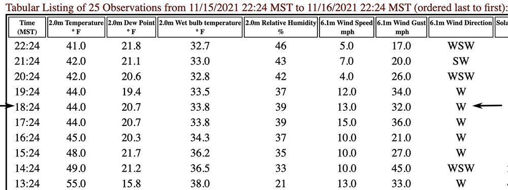
Weather data from Estes Park RAWS, ESPC2. The last observation shown is at 2224 MST Nov. 16, 2021. The observations at the arrows were 12 minutes before the last detected location of the aircraft.
Around the time Single Engine Air Tanker 860 crashed at the Kruger Rock Fire in Colorado at approximately 6:36 p.m. MST on November 16, killing pilot Marc Thor Olson, the Estes Park ESPC2 Remote Automatic Weather Station recorded sustained winds of 13 mph gusting to 32 mph out of the west. The station is 3.7 miles northwest of the fire at 7,892 feet and its anemometer is 20 feet above the ground.
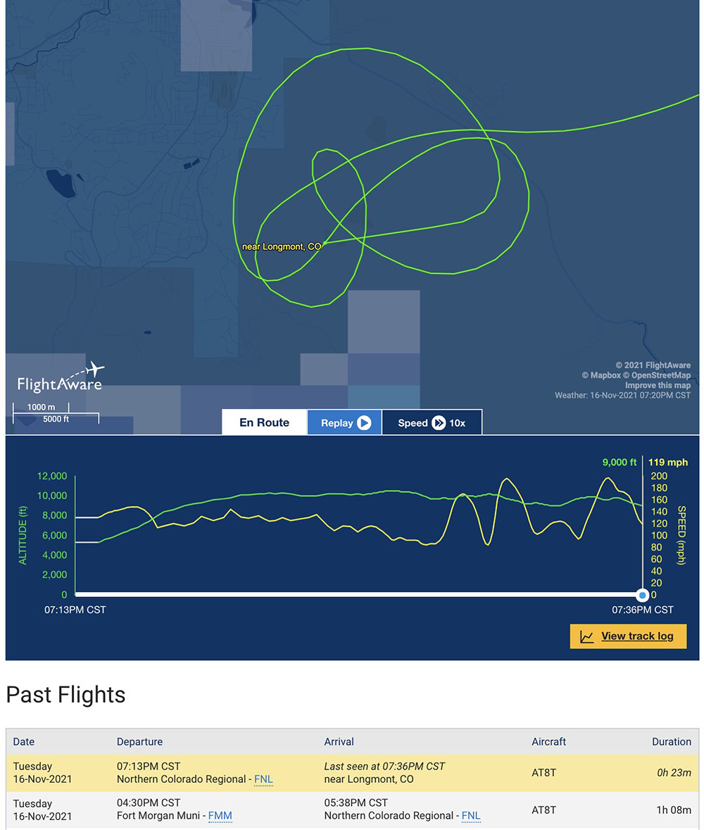
N802NZ, last 10 minutes of flight tracking data, Nov. 16, 2021. FlightAware.
Looking at the flight tracking log from FlightAware above, the wind appeared to be much stronger at the plane’s altitude, which was 8,950 to 10,450 feet while it was over the fire. The highest peak just south of the fire is at 9,400 feet.
Map of the Krueger Rock Fire, Nov. 17, 2021. Colorado’s Multi-Mission aircraft and crew.
As it made four orbits near the fire during the 10 minutes it was in the area, the ground speed of T-860, an Air Tractor 802A (N802NZ) varied from a low of 82 mph while flying west to a maximum of 200 mph when east-bound. These shifts in ground speed were consistent during all four orbits. This indicates a very strong wind out of the west, a direction that is consistent with the data from the weather station.
The last flight of Tanker 860, N802NZ. The flight originated at Northern Colorado Regional Airport. FlightAware. Note that the times are in CST.
There are two reasons that fixed wing air tankers avoid attacking wildfires during strong winds. One, the wind makes it difficult or impossible for the retardant to hit the target, getting blown horizontally as it falls from the aircraft to the ground. Second, flying low and slow, as air tankers have to do, is difficult in mountainous terrain with calm winds, but it can be extremely hazardous during strong winds.
When you add a third complexity of dropping at night using night vision goggles, something that has been done very little in the history of aviation, and never before in Colorado, the pilot had the deck stacked against him. The chances of stopping or slowing the spread of the fire with retardant, water, or any other suppresant, were very, very slim. (There is a report that the operator of the aircraft, CO Fire Aviation, experimented with night drops in Oregon in 2020 and 2021.)
NEW: CO Fire Aviation confirms the pilot killed in the air tanker crash last night was Marc Thor Olson. He told me most people called him Thor.
This is a picture I took of him last night as he was prepping his plane. The crash happened about an hour later #9Newspic.twitter.com/uEOO4tbXwK
The weather forecast available from the National Weather Service that Tuesday afternoon called for continued very strong winds until sundown and a chance for snow Tuesday night. It predicted dry weather on Wednesday and Thursday with high temperatures in the 30s and 40s under mostly sunny skies with the relative humidity around 20 percent. The wind chill was expected to be below zero from Wednesday afternoon until Thursday afternoon. The actual low temperature Tuesday night turned out to be 11 degrees.
Risk vs. reward
With 20/20 hindsight looking at risk vs. reward, this was a very high risk mission. The potential reward was little, considering the likely effectiveness of 700 gallons of suppressant blown off target by strong winds and the weather forecast of a chance of snow in a matter of hours and wind chills the next day below zero.
Who decided to attempt the night flight?
The short answer is, the Larimer County Sheriff’s office ordered the aircraft to respond to the fire, using a “verbal call when needed contract”, an arrangement that was first agreed to on October 5, 2021.
A preliminary map appears to show that the fire was just inside the boundary of the Roosevelt National Forest. The Larimer County Sheriff’s office said on Wednesday Nov. 17 that as of 7 a.m. that day the fire was being managed by a unified command with the US Forest Service and the Sheriff.
In Colorado, Texas, and Wyoming the local county sheriffs are given the responsibility for suppressing wildfires outside of cities unless they are on federal land. The Kruger Rock Fire was in Larimer County.
As Wildfire Today reported November 16, before the fatal flight, T-860 departed from the Fort Morgan, Colorado airport, orbited the fire about half a dozen times, then landed at Northern Colorado Regional Airport at 4:38 p.m. MST. This flight is listed in the image from FlightAware above as one of two flights that day for the aircraft. It turns out that on the first flight it dropped water on the fire, which the pilot reportedly described as “successful”. After it landed at Northern Colorado Regional Airport it reloaded with “fire suppressant” instead of water, and by 6:13 p.m. MST was airborne returning to the fire.
Sunset that day was at 4:44 p.m. MST. The air tanker disappeared from tracking at 6:35 p.m., about 1 hour and 49 minutes after sunset. Air tankers working for the U.S. federal government are allowed to drop only as late as 30 minutes after official sunset.
The Denver Post reported that CO Fire Aviation said in a statement, “There was no aerial supervision or lead plane required for the mission and weather and wind conditions were reported to be within limits of our company standard operating procedures.”
In the video below Juan Browne has strong feelings about this incident. Shortly after posting it, he wrote a comment saying, “GROUNDSPEED NOT AIRSPEED!”
Below is an excerpt from a statement released November 17, 2021 by the Larimer County Sheriff’s office:
Wednesday afternoon CO Fire Aviation released a statement that identified the pilot who was killed Nov. 16 during a night-flying air tanker mission on the Kruger Rock Fire southeast of Estes Park, Colorado.
The CO Fire Aviation family is deeply saddened by the sudden, tragic loss of one of our brothers serving as a tanker pilot. Marc Thor Olson was a highly decorated veteran of both the Army and Air Force with 32 years of service to our country. During Thor’s 42 years of flight, he had amassed more than 8,000 total flight hours with an impressive 1,000 hours of NVG flight including in combat and civilian flight.
Co Fire maintains a close working relationship with multi regulatory agencies and is fully cooperating with the proper authorities and partners during this investigation.
While we are gravely aware of the inherent dangers of aerial fire fighting and the questions that remain; we ask that family and friends be given distance and time to process and heal as we grieve this loss. Your prayers are appreciated during this difficult time.
A preliminary map appears to show that the fire was just inside the boundary of the Roosevelt National Forest. The Larimer County Sheriff’s office said on Wednesday that as of 7 a.m. Wednesday the fire was managed by a unified command with the US Forest Service and the Sheriff. In Colorado the local county sheriffs are given the responsibility for suppressing wildfires outside of cities unless they are on federal land.
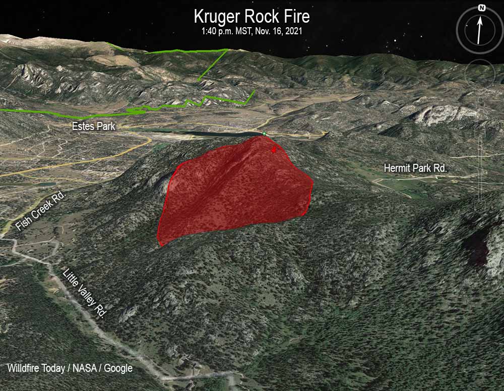
The map shows the approximate location of the Kruger Rock Fire. It is based heat detected by satellites as late as 1:40 p.m. MST Nov. 16, 2021. Clouds degraded the ability of satellites to obtain good quality data.
The crash occurred at about 6:35 p.m MST on Tuesday Nov. 16 while attempting to suppress the fire. This was about 1 hour and 49 minutes after sunset, and was the first time a fixed wing air tanker had dropped fire suppressant on a fire at night in Colorado.
11:29 p.m. MST Nov. 16, 2021
File photo of the aircraft that crashed November 16, 2021. Air Tractor AT-802A, N802NZ, owned by CO Fire Aviation. Photo by Aviation Specialties Unlimited September, 2018.
An air tanker that was working the Kruger Rock Fire southeast of Estes Park, Colorado Tuesday night November 16 crashed, killing the pilot, the only person on board. The Single Engine Air Tanker (SEAT) had taken off from Northern Colorado Regional Airport, formerly known as the Fort Collins-Loveland Municipal Airport, at 6:13 p.m. MST Nov. 16 and disappeared from flight tracking 22 minutes later at 6:35 p.m. MST. Earlier in the day it departed from the Fort Morgan, Colorado airport, orbited the fire about half a dozen times, then landed at Northern Colorado Regional Airport at 4:38 p.m. MST.
The incident was first reported by KUSA, 9News in Denver. Marc Sallinger, reporter for the station, had interviewed the pilot earlier in the day, and wrote on Twitter, “My thoughts and prayers are with the pilot who took off tonight, so excited for this history-making flight. He told me ‘this is the culmination of 5 years of hard work.’ He showed me his night vision goggles and how they worked. He was so kind. Holding out hope for him.”
Eyewitnesses reported the crash at approximately 6:37 p.m., but in the dark it was very difficult to pinpoint the location. After three hours of searching, firefighters found it near the south end of Hermit Park. Unfortunately the pilot was deceased.
The aircraft was an Air Tractor 802A, registration number N802NZ, owned by CO Fire Aviation. In 2018 we wrote about the company’s efforts to configure this aircraft for fighting fires at night. Helicopters have been doing it off and on for decades, but a fixed wing air tanker dropping retardant on a fire at night is extremely rare. In 2020 and 2021 CO Fire Aviation had one of their SEATs working on a night-flying contract in Oregon. The company says they are the only operators of night-flying fixed wing air tankers.
Earlier this year a video was posted on YouTube that featured CO Fire Aviation conducting a night-flying demonstration at Loveland, Colorado. That segment begins at 8:15 in the video.
BREAKING: We’re hearing reports this plane has crashed while fighting the wildfire in Estes Park
It was the first time a fixed-wing aircraft had ever fought a fire at night using night vision here in CO
For the first time ever, firefighters will use a fixed-wing aircraft to fight a fire at night when a plane takes off soon loaded with fire suppressant. This has never been done before. It’ll fly all night to fight the wildfire in Estes Park #9Newspic.twitter.com/K5ds8Pl22x
The map shows the approximate location of the Kruger Rock Fire. It is based heat detected by satellites as late as 1:40 p.m. MST Nov. 16, 2021. Clouds degraded the ability of satellites to obtain good quality data.
In Colorado the local county sheriffs are given the responsibility for suppressing wildfires outside of cities. The Larimer County Sheriff’s office has not released much more information about the Kruger Rock Fire since the pilot of a single engine air tanker was killed in a crash while attempting to suppress the fire at about 6:35 p.m MST on Tuesday Nov. 16. It occurred about 1 hour and 49 minutes after sunset, and was the first time a fixed wing air tanker had dropped fire suppressant on a fire at night.
Wednesday afternoon the operator of the aircraft, CO Fire Aviation, released the name of the pilot, Marc Thor Olson.
The Sheriff’s office said Wednesday morning that there were changes in the evacuation areas, which can be seen on their map. The size of the fire was estimated to be 140 acres.
An investigation into the cause of the fire has revealed high winds blew a tree onto a power line causing it to arc and start the fire.
4:50 p.m MST Nov. 16, 2021
Map showing the approximate location of the Kruger Rock Fire. The two red dots represent heat detected by a satellite at 11:06 a.m. MST Nov. 16, 2021.
A new wildfire in Colorado has prompted evacuations east of Rocky Mountain National Park.
The Kruger Fire was reported at about 7 a.m. near Little Valley Road and Fish Creek Road near Kruger Rock 3 miles southeast of Estes Park and 2 miles east of Mary’s Lake. It is about 3 miles east of Rocky Mountain National Park.
At 3 p.m. fire officials estimated it had burned 115 acres. There are 150 personnel currently working the fire with more ordered.
At about 1:10 p.m. local time the Larimer County Sheriff’s Office issued a mandatory evacuation order for the area between Pole Hill Road and Panorama Peak on the east side of Highway 36. An hour earlier the office had issued a mandatory evacuation order for the area of Meadowdale, and south to the Boulder County line, to include Big Elk Meadows and Pinewood Springs west of Highway 36.
Kruger Fire evacuation map, 1:32 p.m. MST Nov. 16, 2021.
Colorado Highway 36 is closed in the area.
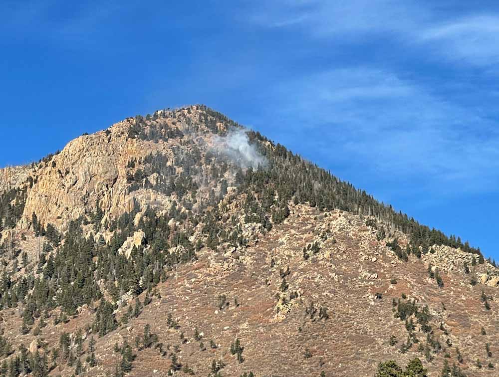
Kruger Rock Fire. Image by Michael Warren the morning of Nov. 16, 2021.
Strong winds in the fire area have kept firefighting aircraft grounded, except for an intelligence-collecting Multi-Mission plane flying thousands of feet over the fire. The wind direction at a weather station just west of the fire (at 7,841 feet) was quite variable Tuesday, blowing from the south, west and north at 5 to 13 mph gusting at 25 to 34 mph. At noon it was 73 degrees with 26 percent relative humidity. The forecast for the fire area calls for continued very strong winds until sundown and a chance for snow Tuesday night. It will be dry Wednesday and Thursday with high temperatures in the 30s and 40s under mostly sunny skies with the relative humidity around 20 percent. The wind chill will be below zero from Wednesday afternoon until Thursday afternoon.