Slower start to fire season in some areas

The recent cooler than normal weather and very heavy snow has led to a slower start of the wildfire season in Colorado and the Black Hills of South Dakota. By this time last year we had written about two significant timber fires in these areas, the 4,140-acre Lower North Fork Fire southwest of Denver that killed three residents in their homes on March 26 and the Apple Fire south of Custer, South Dakota that burned 500 acres on March 28.

The primary reason for fewer large timber fires is the weather, of course. Boulder, Colordo had twice the average amount of snow in March, with 22 inches. April brought record-setting snow to parts of Colorado and the Black Hills. Boulder experienced not only the snowiest April on record, about 50 inches, but it was the snowiest of any month in history there. In Rapid City, South Dakota a new record was also established for the most snow ever recorded in the month of April with 43 inches, crushing the previous record of 31 inches.

The snowpack map below was current as of April 1 and does not include the heavy snow this month.

Mountain snowpack, April 1, 2013. It does not include the heavy snow in CO and SD in April.

Compare this year’s map above, with the map for last year below:

Mountain snowpack, April 1, 2012

And then there is the drought to consider.

Drought Monitor

As we have often stated, precipitation and temperature in the winter and early spring are not the only factors that influence the severity of the wildfire season in mid-summer and fall. Sure, a wet, cool Spring can delay the occurrence of late Spring and early Summer fires, but by mid-Summer the most important variable is the recent weather at that time. If it is hot, dry, and windy, you can have a busy fire season even following a wet winter. Predictions in April of how active the July through November fire season will be should be taken with a grain of salt. They are about as accurate as flipping a coin.


Wildfire news, April 9, 2013

200 fires near Mayo, Ireland

Firefighters have responded to approximately 200 wildfires near Mayo in Ireland in the last ten days. The worst of the gorse fires in recent days have been at Shanwar, Foxford; Killawalla, Westport; and Treanagleragh, Kiltimagh.

Distress flare causes wildfire

Some rocket scientists boaters in Virginia have been charged with misdemeanors after they started a wildfire by discharging a flare distress signal from a boat on Smith Mountain Lake. The fire burned about a quarter-acre and one round hay bale. There was no emergency that precipitated the discharge of the flare.  Someone witnessed the incident and called 9-1-1. The Smith Mountain Lake Marine Volunteer Fire & Rescue responded and quickly extinguished the fire.

Wildfire across from Indiana Fire Department

Two rocket scientists males, in an effort to burn the insulation off (probably stolen) copper wire across from the Porter Fire Department in Indiana at 2 a.m. Friday morning, accidentally allowed the fire to escape, igniting nearby vegetation. The Fire Department responded and put out the fire. One of the males escaped, while the other was transported to the Porter County Jail.

A wildfire followed by winter storm in Colorado

Yesterday Wildfire Today told you about the Red Flag Warning and Winter Storm Warning for Colorado, both happening on the same day. One of the areas not covered by the Red Flag Warning, Sterling County in the northeast corner of the state, had a 2,600-acre wildfire yesterday. Firefighters were no doubt thankful for the snow storm that followed a few hours later. Here is the forecast for Sterling today:

Snow with widespread blowing snow. High near 20. Wind chill values as low as -10. Windy, with a north wind 26 to 28 mph, with gusts as high as 43 mph. Chance of precipitation is 90%. Total daytime snow accumulation of 2 to 4 inches possible.

Wildfire leaders in the Black Hills discuss the coming fire season

KEVN TV in Rapid City interviewed two wildfire honchos in the Black Hills of South Dakota, asking them about the outlook for this fire season. KEVN’s video and article are HERE, but below are some excerpts:

Jay Esperance, Director of South Dakota Division of Wildland Fire:

It’s looking like it will be at least an above average fire season. The southern Black Hills I’m really worried about.

Todd Pechota, Fire Management Officer for the Black Hills National Forest:

From all indications that we are hearing from fire weather forecasters, we’re preparing as if we are going to have another very active fire season in 2013.

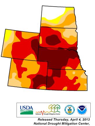
If the current drought continues and if the weather this summer is hot and dry, it could be a busy fire season in portions of the Great Plains and Rocky Mountains. Below is the Drought Monitor for ND, SD, NE, KS, WY, and CO.

Drought Monitor, April 4, 2012

Most of the West is in drought

(Updated map, March 14, 2013) 

Drought Monitor, March 12, 2013

All of the western United States, except for portions of the northwest and the northern Rockies, are in drought.

When people ask me this time of the year what the wildfire season is going to be like, I usually tell them to ask me again in August and I’ll have a better idea. While drought has an effect on how busy a fire season will be, the more important factor is the weather DURING the fire season. If it is hot and dry, there will be more blackened acres than average. Cool and wet weather in the summer results in a slower fire season.

Wildfire potential, May through August, 2011

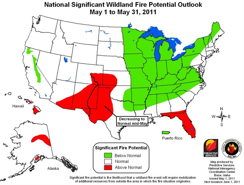
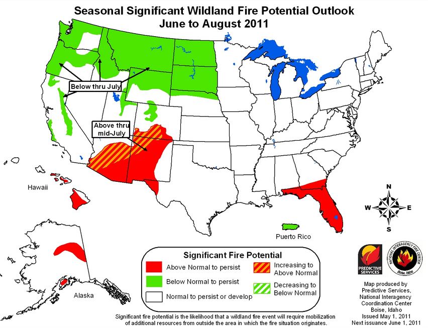
The Predictive Services section at the National Interagency Fire Center issued their National Wildland Significant Fire Potential Outlook for May through August, 2011. If this turns out to be accurate, it looks like it will be a quiet or average summer season for the United States, with the exception of portions of the southwest and Florida.

The primary factors influencing these outlooks are:

  • La Niña: The ongoing La Niña influence is forecast to weaken through early summer of 2011 and return to neutral conditions.
  • Drought: Drought will persist across portions of the southwestern U.S. with improvement expected over the southeastern U.S. and portions of Texas.
  • Fuel Dryness: Dryness observed over Florida and the extreme southeast states during spring will diminish by June. Unusually dry areas with above normal significant fire potential will expand westward and northward across New Mexico and Arizona through the summer while easing through much of Texas.

(Click on the images to see larger versions.)

National Wildfire outlook May 2011

National Wildfire outlook June-Aug 2011

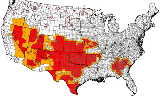
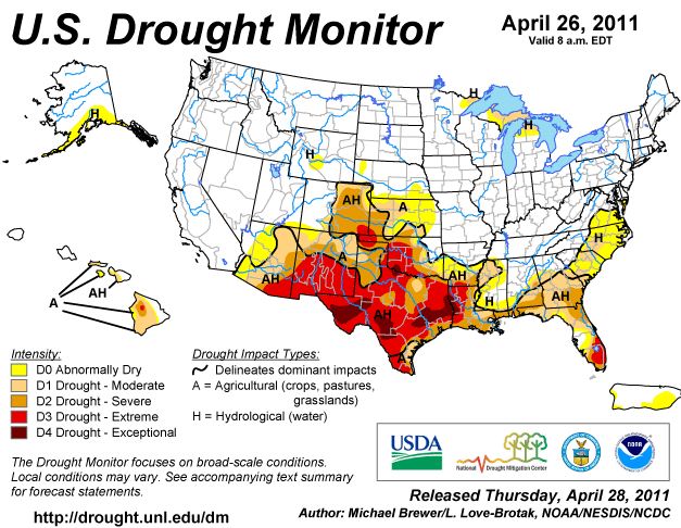
Here is the latest revision of the Drought Monitor released by the U.S. Department of Agriculture:

Drought Monitor 4-26-2011


Wildfire potential, April through July, 2011

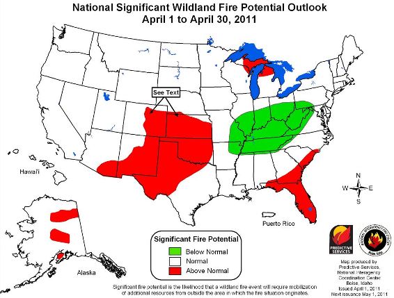
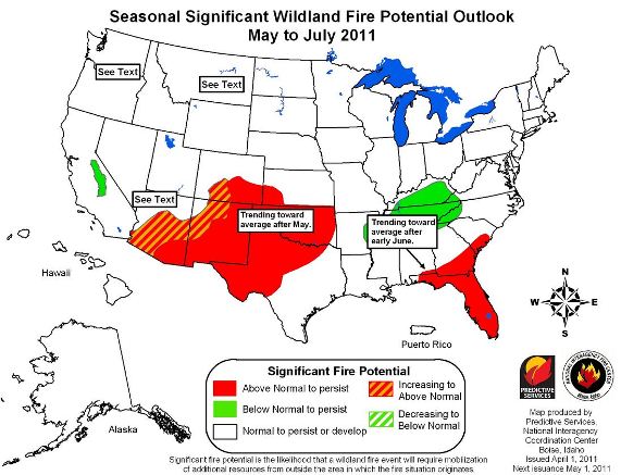
The Predictive Services section at the National Interagency Fire Center issued their National Wildland Significant Fire Potential Outlook today for April through July, 2011.

The primary factors influencing these outlooks are:

  • La Niña: The ongoing La Niña episode is forecast to weaken in the spring and return to El Niño-Southern Oscillation neutral conditions.
  • Drought: Conditions are expected to persist and worsen across portions of the southwestern, southern, and central U.S. and along the mid-Atlantic seaboard. Some improvement is likely over Arkansas and sections of Virginia.
  • Fuel Dryness: Dryness observed over Florida and the extreme southeast states during the winter will continue into the summer. Unusually dry areas with above normal significant fire potential will expand westward across New Mexico and northward in Arizona through spring.

Wildfire potential, April 2011

Wildfire potential, May-July 2011

The latest revision of the Drought Monitor was released yesterday by the U.S. Department of Agriculture:

Drought Monitor 3-31-2011