Anderson Creek fire in Oklahoma and Kansas

(UPDATED at 11:30 a.m. March 25, 2016)
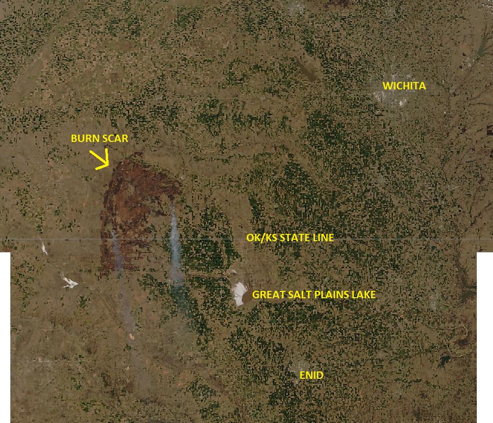
KS-OK fire from space
The Anderson Creek Fire in Oklahoma and Kansas as seen from space. Photo via Damon Lane
@KOCOdamonlane

****

(UPDATED at 12:15 a.m. CDT, March 25, 2016)

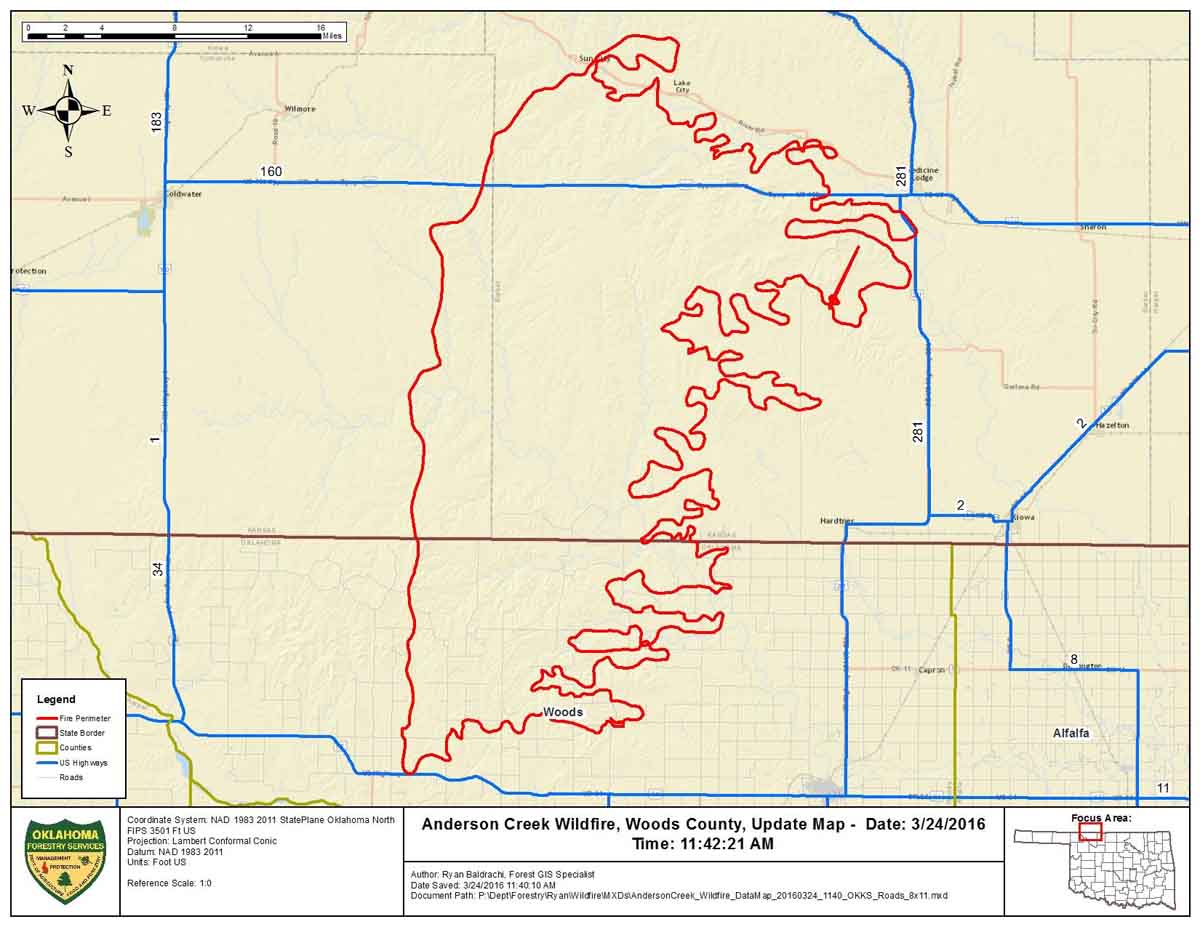
This map was provided by Oklahoma Forestry Services, along with the information that the fire had burned an estimated 397,420 acres and was 0% contained Thursday morning.

Map Anderson Ck Fire 3-24-2016

****

(UPDATED at 6:12 p.m. CDT March 24, 2016)

The video below is a recording of the briefing by public officials of Barber County Kansas the morning of March 24, 2016 about the very large fire insouthern Kansas and northern Oklahoma. It was originally broadcast on Periscope by Amy Bickel, but since recordings there are automatically deleted after 24 hours, we preserved it here. It was recorded off a computer monitor, so we apologize for the low quality.

In the briefing referenced above, the County Attorney said “397,420 acres have burned over the last couple of days”. He did not indicate if that was the size of the very large fire in our maps, or if the acreage includes multiple fires. He also said two homes were destroyed.

The map below shows heat detected by a satellite at 2:25 p.m. on March 24. The light vegetation in the area may sometimes ignite, burn up completely, and then cool before the next satellite overpass, which can be about 12 hours apart. In this case the mapped data may under-report the true extent of the fire.
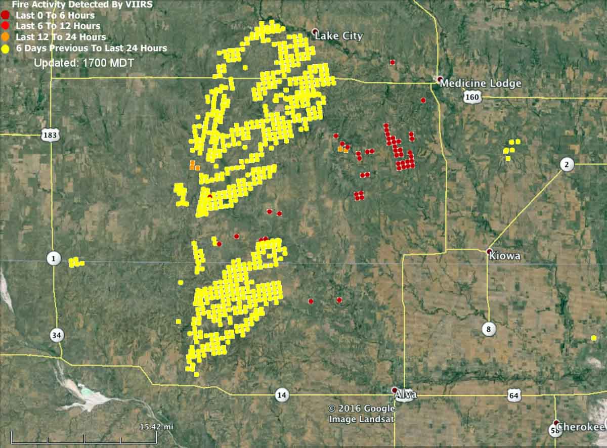
map fire wildfire kansas oklahoma medicine lodge
Kansas-Oklahoma fire map at 2:25 p.m. CDT March 24, 2016.

Here is an excerpt from an article at WIBW, dated March 24 at 2:10 p.m.

Strong winds have thwarted efforts to contain a wildfire that has burned 620 square miles of rural land in Oklahoma and Kansas, and it’s now approaching populated areas.

Oklahoma Forestry Services spokesman Mark Goeller said Thursday that strong winds shifted the direction of the fire late Wednesday and overwhelmed existing containment lines.

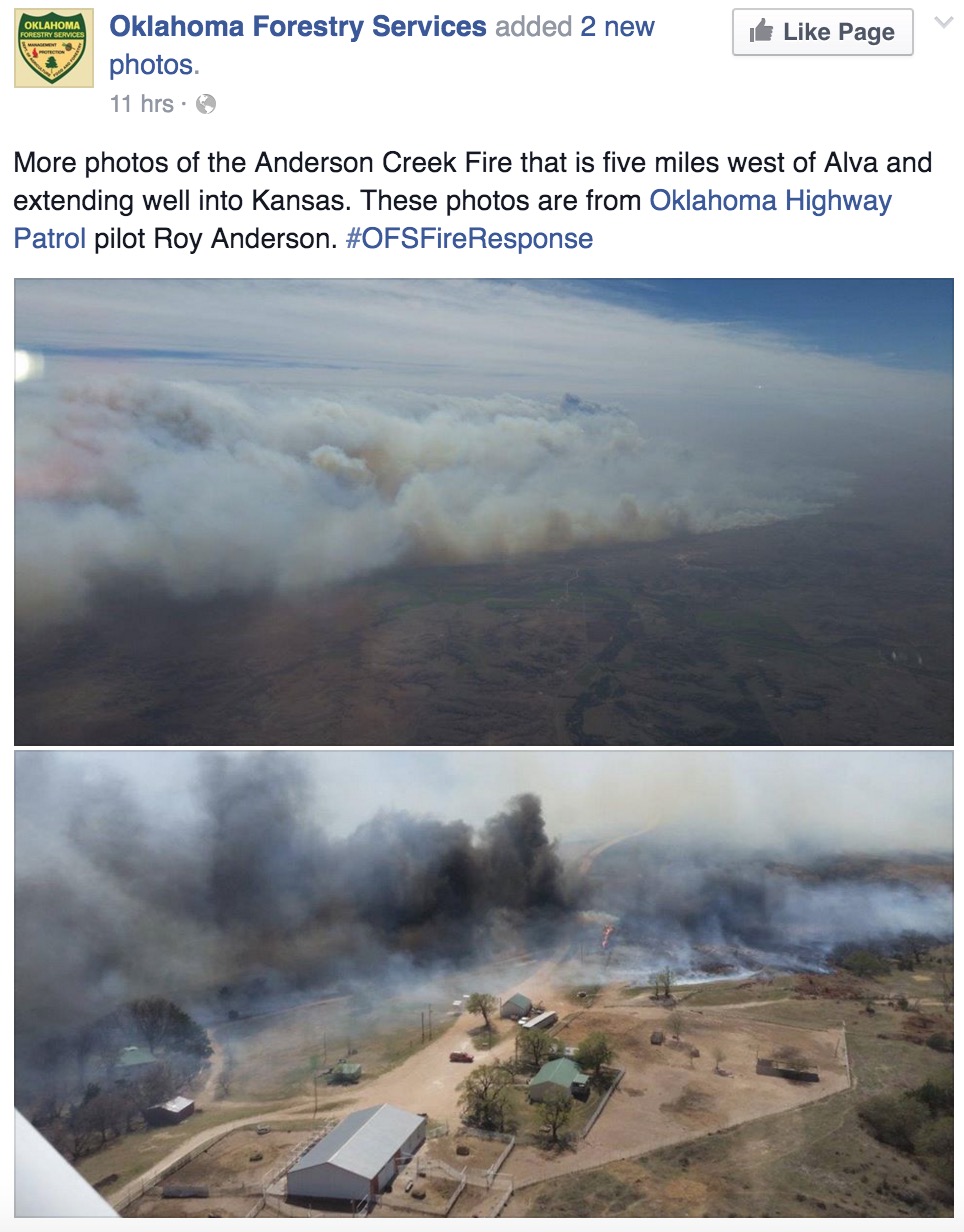
Officials are now monitoring a part of the blaze 5 miles away from Alva, Oklahoma, where about 5,000 people live. No mandatory evacuations have been issued in Oklahoma, though Goeller says officials are forming contingency evacuation plans as crews work to slow the fire’s spread.

Goeller says wind conditions and humidity are expected to improve throughout the day, making progress on containment more likely…

Anderson Creek Fire 3-24-2016

Continue reading “Anderson Creek fire in Oklahoma and Kansas”

Three fire trucks damaged while fighting fire started by exploding targets

Shooters using exploding targets start 160-acre fire near Salina, Kansas.

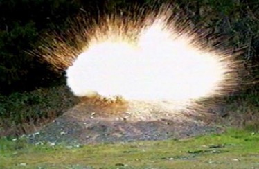
exploding target
File photo of exploding target. Photo courtesy of Minnesota DNR.

A sheriff’s office spokesperson said the people who started a 160-acre fire using exploding targets did nothing illegal, according to the Salina Journal, in spite of the fact that it took firefighters from four fire districts to suppress the fire which threatened homes and damaged fence posts and three fire trucks.

Not everyone who starts wildfires with exploding targets gets a free pass from law enforcement. For example, Tristan C. Olson, of Missoula and Caitlin E. Hoover, of Stevensville, Montana were ordered to pay $9,450 in restitution after starting a fire that burned 50 acres east of Florence, Montana in 2014.

Apparently exploding targets are popular in Kansas. After numerous reports over the last week of two explosions near Wichita, KWCH news tracked down the source to five pounds of powder from explosive targets.

Exploding targets consist of two ingredients that when mixed by the end user create an explosive when shot by a high-velocity projectile. They have caused many fires since they became more popular in recent years, have been banned in some areas, and caused the death of one person. In June, 2013 a man attending a bachelor-bachelorette party in Minnesota was killed after shrapnel from the device struck him in the abdomen causing his death. The Missoulian reported that two years ago a woman in Ohio had her hand nearly blown off while taking a cellphone video of a man firing at an exploding target placed in a refrigerator about 150 feet away.

March and April are historically busy for wildland firefighters in Kansas

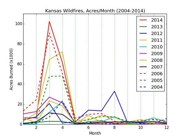
Far more acres burn in March and April in Kansas than the other months.

Wildfire occurrence data collected by the Kansas Fire Incident Reporting System shows that over an 11-year period, from 2004 through 2014, there were two spikes in the number of reported fires during the year — in March/April and in July. However, by far, most of the acres burned in March and April.

Below are excerpts from a Kansas State University article written by Chip Redmond and Mary Knapp of the University’s Weather Data library.

****

“…Of the eleven years of recorded KFIRS data, 2014 had both the most land area burned (187,500 acres) and the highest number of reported fires (8,075) in a year. In both land area and number, fires followed the typical curve of the previous 10 years, with a peak during the spring months of March and April.

Acres burned in Kansas by month, 2004-2014
Acres burned in Kansas by month, 2004-2014. Data from Kansas State University.
number of reported wildfires in Kansas, by month, 2004-2014
The number of reported wildfires in Kansas, by month, 2004-2014. Data from Kansas State University.

This trend of spring wildfires coincides very well with prescribed burning season. Early spring is typically characterized by dead/cured fuels, warming temperatures, low relative humidity, and little precipitation. Often, if the late fall and winter are below normal in precipitation and/or the region is in a drought, these spring conditions are enhanced – providing explosive conditions for fire growth.

This was the case entering 2014. However, conditions were worsened by an increased fuel load from late summer rains of 2013 that brought some relief to the prolonged drought which peaked in 2012.These combined factors led to a peak of 156,600 acres burning in March/April 2014 alone. Of the 61 days possible in March and April, almost half (29) had more than 1000 acres burned statewide each day. Two days (Jan. 26 and Feb. 19) occurred outside of these months. Below, the March/April calendar with red days were those in which more than 1000 acres statewide were burned. Cold frontal passages throughout the period are marked on their associated day. Continue reading “March and April are historically busy for wildland firefighters in Kansas”

Red Flag Warnings, February 8, 2016


The National Weather Service has issued Red Flag Warnings for areas in Texas, Oklahoma, Kansas and California.

In the California counties of Ventura and Los Angeles 20 to 35 mph northeast winds with gusts of 40 to 50 are in the forecast until 6 p.m. tonight. The Texas and Oklahoma areas under Red Flag Warnings from noon until 6 p.m. CST tonight will experience relative humidities in the teens with wind gusts out of the north to northwest at around 30. Firefighters in south-central Kansas should expect 20 to 30 mph northwest winds gusting to 45 mph along with a minimum humidity of 30 percent from noon until 7 p.m. CST tonight.

The map was current as of 8:45 a.m. MDT on Monday. Red Flag Warnings can change throughout the day as the National Weather Service offices around the country update and revise their forecasts and maps. For the most current data visit this NWS site.

Fire jumps Missouri River, from Kansas into Missouri

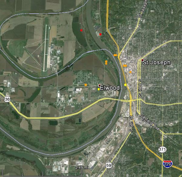
A fire that burned on both sides of the Missouri river forced residents to evacuate from an area in St. Joseph, Missouri on Sunday. Fire personnel believe the fire started in Elwood, Kansas and jumped the river, spreading over hundreds of acres and for about five miles along the river near St. Joseph. The fire is much less active today, but the area is under a Red Flag Warning.

wildfire Elwood St. Joseph
The yellow, brown, and red dots represent the approximate location of heat detected by a satellite. The locations of the dots are accurate to within about a mile.

We checked Google Earth and found that the river in that area is about 0.16 miles (820 feet) wide. Depending on the vegetation, weather, and topography, it is not unusual for burning embers to start fires quite a distance from the main fire. There is a trial going on now in San Diego County that revolves around a fire that may have been ignited by an ember that traveled 0.44 miles and started a new fire that destroyed 36 homes in San Marcos, California. And last September on the King Fire near Pollock pines in California an ember started a spot fire approximately 2 miles ahead of the main fire front. There have been reports of spot fires starting even farther away.

UPDATE, March 17, 2015: It took me a while to find this. It is in a report about bushfires in Australia, “Report on the Physical Nature of the Victorian Fires occurring on 7th February 2009“. It not about burning embers, but lightning caused by the fire.

In 2003, lightning induced by a pyrocumulus cloud started fires in the Snow River National Park, 25 km [15 miles] ahead of the fire front. These fires did develop into a significant area. Other examples exist of this phenomenon.

Four civilians killed in recent wildfires

At least four civilians have been killed in wildfires in Chile, India, and the United States since March 12.

In Maryland on Thursday authorities found the body of a man believed to be in his 70s, after they suppressed a wildfire in the western part of the state.

Also on Thursday a man in Halstead, Kansas was fatally burned trying to put out a grass fire. After his pants caught on fire while trying to stomp out flames, Fred Rodenberg suffered 4th and 5th degree burns over 50 percent of his body.

In India, Robert Lobo, 58, died Friday after becoming entrapped by a fire while he was cutting trees in the forest in the district of Kasaragod.

In Chile the death of a woman in her 60s who suffered a heart attack was blamed on a large wildfire that required the evacuation of 7,000 people near Valparaiso. Thirty-two people were injured, including 19 firefighters, a spokesperson from the National Emergency Office said. Five of the firefighters were badly injured, but their lives were not in danger.

In northeast Nebraska on Friday an elderly man suffered burns on his legs when he tried to put out a grass fire that started when strong winds blew embers out of a burn barrel. The fire blackened 30 acres near Crofton.