CAL FIRE air tanker crashes while fighting fire near Yosemite

(UPDATE at 2:22 p.m. PDT, October 8, 2014)

The pilot that was killed in the air tanker crash near Yosemite National Park on Tuesday has been identified as Geoffrey “Craig” Hunt, age 62, of San Jose. More information is at Fire Aviation.

****

(UPDATE at 12:31 a.m. PDT, October 8, 2014)

Tuesday evening emergency personnel were able to access the site of the CAL FIRE air tanker that crashed near Yosemite National Park and determined that the pilot on board had died. The air tanker (Tanker 81) based out of the Hollister Air Attack Base had been fighting the Dog Rock Fire near El Portal at Yosemite National Park when officials lost contact with it late Tuesday afternoon.

The family requested that the agency withhold release of the pilot’s name until all immediate family members can be notified.

Our sincere condolences go out to the family and coworkers.

There is a report that two air tanker pilots witnessed the accident, saying that as the aircraft pushed over a ridge in the steep canyon, descending to the intended retardant drop area, a wing struck an object on the ground.

A civilian on the ground, Don Talend, of West Dundee, Illinois, told the Associated Press that he saw a plane flying low through heavy smoke near a burning ridge when a wing appeared to waggle or flip up.

The Modesto Bee reported:

Kirstie Cari, the owner of El Portal Market, said the plane crashed within sight of her store. She was in the kitchen at the time and didn’t see it, but said witnesses told her the plane came tumbling over the ridge line, cartwheeled and crashed right in front of a big wall of rock.

Cari said the crash lit a second fire in front of the first blaze and brought debris tumbling down onto Highway 140, which was closed east of El Portal at the time of the crash. She said helicopters had worked to suppress it, but the area was still smoldering about 30 minutes later.

Immediately after the crash, CAL FIRE grounded their remaining air tankers, which is standard procedure after a serious accident.

The S-2T air tanker, registration number N449DF, was designated Tanker 81, one of 23 S-2Ts that are maintained and flown by DynCorp for CAL FIRE. The agency also has one spare that is used to fill in as needed when an aircraft is undergoing maintenance. CAL FIRE hires their own pilots for their 11 UH-1H Super Huey helicopters, but they are also maintained by DynCorp.

The last time a CAL FIRE air tanker crashed was in 2001, when two tankers collided while fighting a fire in Mendocino County, killing both pilots, Daniel Berlant, spokesperson for CAL FIRE said.

The agency had another plane crash in 2006, when a battalion chief and a pilot were killed in the crash of an air attack plane in Tulare County.

The S-2 first flew in 1952 and the U.S. Navy discontinued the use of them in 1976. They were used for detecting enemy ships and submarines and for dropping torpedoes. The ones currently being used by CAL FIRE were converted from piston to turbine engines between 1999 and 2005. Some media outlets are incorrectly reporting that the Tanker that crashed on Tuesday was built in 2001. That may be the date that it was converted to turbine engines and was given the new model name S-2F3 Turbo Tracker. They are now commonly referred to as S-2T, with the “T” standing for turbine engine.

Wednesday morning the Dog Rock Fire is reported to be 150 acres with no containment. A Type 3 Incident Management Team (IMT) is at the scene, with Mills as Incident Commander during the day and Wills at night. A “short” version of Jeanne Pincha-Tulley’s IMT has been activated. She normally is the Incident Commander of a Type 1 IMT.

The fire, reported at 2:45 Monday afternoon, is north of Highway 140 and is burning uphill toward the north in the direction of the community of Foresta, which has been evacuated. Electrical power has been shut off in the area.
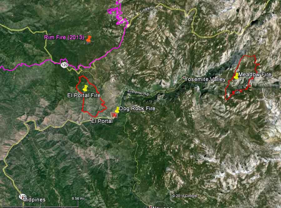
map Dog Rock Fire
Map, showing heat detected on the Dog Rock Fire (the red square) by a satellite at 11:33 p.m. October 7, 2014. The location can be accurate to within a mile. The map also shows the perimeters of two other fires in 2013, the El Portal and Meadow Fires. The 2013 Rim Fire is also shown. (click to enlarge)

****

(UPDATE at 9:12 p.m. PDT, October 7, 2014)

There is still no news about the condition of the pilot in the crash of the S-2T CAL FIRE air tanker near Yosemite National Park late Tuesday afternoon.

Ken Yager heard a loud boom and took the photo below. The extreme terrain helps to explain why it is taking rescuers hours to reach the site.
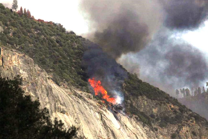
S-2T air tanker crash
S-2T air tanker crash. Photo by Ken Yager.

Below is an excerpt from an article at ABC30:

…A California Highway Patrol spokesman, Officer Steven Lewis, said CHP Sgt. Chris Michael witnessed the crash as he was helping to close state Route 140 where it enters the park.

“All the tourists and residents were being turned away,” Lewis said, when Michael reported that he had just witnessed “a bomber collide into the river canyon, the canyon wall, and watched it explode in flames and reported there was plane debris landing in the highway.”

The canyon wall is above the highway and the Merced River, Lewis said.

“It’s almost vertical canyon walls,” Lewis said, “and the road was cut in 100 years ago right along the river. Anything that falls from the top is going to fall right on the roadway.”

There were no reports of any injuries on the ground as a result of debris.

Don Talend, of West Dundee, Illinois, said he may have seen the plane go down. Talend and friends were vacationing at the park when they stopped to snap some photographs of the fire, which was several miles away.

He told The Associated Press by phone that he saw a plane flying low through heavy smoke near a burning ridge when a wing appeared to waggle or flip up.

The plane “disappeared into the smoke and you heard a boom,” he said.
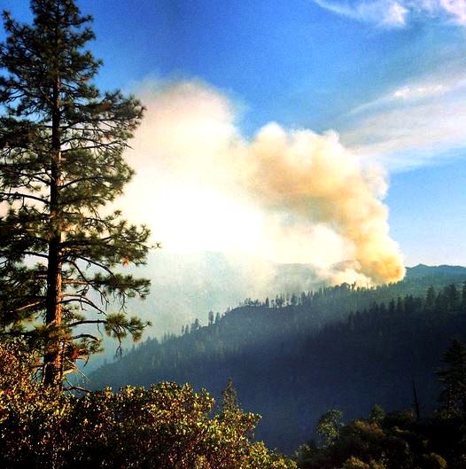
Dog Rock Fire
Dog Rock Fire, 5:31 p.m. PDT, October 7, 2014. Photo by Madison Sites.

****

(UPDATE at 7:35 p.m. PDT, October 7, 2014)

The Fresno Bee reported that Kari Cobb, spokesperson for Yosemite National Park, said, “We saw it crash. It was witnessed by park staff as well as some community members”.

Ms. Cobb was referring to the air tanker that crashed while fighting the Dog Rock Fire near the park. CAL FIRE announced earlier that they lost contact with an air tanker. At 6:21 p.m. PDT spokesperson Daniel Berlant said the aircraft was an S-2T air tanker.

The condition of the pilot, the only person on board, is not known. Emergency personnel are hiking to the crash site.

The 23 CAL FIRE air tankers, all S-2Ts which carry 1,200 gallons, are maintained and flown by a contractor, DynCorp. However, CAL FIRE hires their own pilots for their 11 UH-1H Super Huey helicopters.

Yosemite National Park has a web cam pointed in the general direction of the fire.

T-94 and T-95 at RDD 8-7-2014
File photo of two S-2T air tankers, T-94 and T-95, at Redding, California, August 7, 2014. Photo by Bill Gabbert.

****

(Originally published at 5:54 p.m. PDT, October 7, 2014)

The California Department of Forestry and Fire Protection said they lost contact with an air tanker that was flying over a wildfire near Yosemite National Park.  The aircraft was assigned to the Dog Rock Fire burning near Yosemite’s Arch Rock. The status of the aircraft and the pilot have not been determined.

CAL FIRE’s announcement was at 5:43 p.m. PDT, October 7. When more information is available, we will update this article.

The Dog Rock Fire began Tuesday afternoon at Dog Rock on the El Portal Road between the park boundary and Arch Rock Entrance Station. The fire was reported around 2:45 p.m. PDT at the last report was approximately 130 acres.

The community of Foresta has been evacuated. El Portal Road is temporarily closed to all through traffic from the park boundary near Yosemite View Lodge from the west and at the junction of the El Portal and Big Oak Flat Roads from the east.

Dog Rock Fire
The Dog Rock Fire, as seen from Turtleback Dome at 6 p.m. PDT, October 7, 2014.

Arkansas firefighter dies in the line of duty

Posted on Categories UncategorizedTags ,

On Wednesday Assistant Chief J.B. Hutton, Jr., who had been fighting fire in Dermot, Arkansas since the mid-sixties, collapsed at a vegetation fire after bending down to pick up a hose. His coworkers performed CPR but he passed away later at a hospital.

In his later years with the department he primarily operated the engines and shared his experiences with other firefighters.

Our sincere condolences go out to Chief Hutton’s family and coworkers.

Montana Fire Chief dies one month after vehicle accident

Dave Anderson, a volunteer Fire Chief in Fort Shaw, Montana died Monday, a month after he was injured in a traffic accident. Cascade County Deputy Coroner Jason Boyd said the Chief died as a result of injuries suffered in the crash, along with cardiac complications. The Montana Highway Patrol said he was driving a water tender on U.S. Highway 89 on July 22 when his vehicle collided with a brush truck that was making a U-turn because the driver had missed a turnoff.

On June 19 another Montana firefighter and a family of five was killed when the fire engine driven by Three Forks Fire Chief Todd Rummel experienced a mechanical problem that locked up one of the wheels, causing the truck to veer into the path of the oncoming pickup. Investigators determined that Chief Rummel died of smoke inhalation while unconscious. Matthew Boegli, Crystal Ross and their three young children died of blunt-force trauma on impact. The Chief was driving back to Three Forks at 55 mph while returning from Helena where the truck had been undergoing repairs to its water system.

Our sincere condolences go out to the families.

Report released on dozer operator fatality in Idaho

Dennis Long
Dennis James Long. The photo in the report was provided by the Long family.

The Bureau of Land Management (BLM) and the Idaho Department of Lands (IDL) have released their factual report on the fatality of Dennis James Long, 65, the dozer operator who died while working on the Pardee Fire northwest of Kamiah, Idaho July 8, 2013. The fire was on BLM land under fire protection of the IDL.

Mr. Long was constructing fireline with a privately owned dozer on the fire. After noticing from a distance a period of inactivity by the dozer, his supervisor checked on him and found him unresponsive. Resuscitation efforts were not successful.

The report concluded the following:

****

“No findings were directly attributable to the cause of death.

Cause of Death: The Idaho County Coroner identified the cause of this fatality as severe coronary artery disease.

Non Attributable Findings: (Non-Causal)

Finding 1: The dozer and transport were not inspected prior to use for the Pardee fire. Visible hazards would have found the dozer unserviceable (See Appendix C: Photographs). An agreement for the contracted dozer and transport was not in place prior to use on the fireline (See Appendix B: No Contract Agreement in Place). This factor is determined to be non-finding to the accident.

Finding 2: The Contract Dozer Operator was operating on the fireline without wearing his PPE. This factor is determined to be non-finding to the accident.

Finding 3: Command of the fire was not transferred to a more qualified and available person when the complexity exceeded Type 5 Incident Commander qualification levels. This factor is determined to be non-finding to the accident.

Finding 4: Not all resources on the fire had the appropriate Emergency Medical Services (EMS) frequencies. This factor is determined to be non-finding to the accident.

Finding 5: The local IDL fire protection district does not have a consistent approach to a medical plan. This factor is determined to be non-finding to the accident.”

****

The incident was originally covered by Wildfire Today July 10, 2013.

Simulation of winds affecting the Yarnell Hill Fire

This is an animation developed by Janice Coen, Ph.D., a Project Scientist at the National Center for Atmospheric Research in Boulder, Colorado. It simulates through a coupled weather-wildland fire environment model the spread of the Yarnell Hill Fire and the wind direction and speed. The arrows indicate the wind direction; the length of the arrows vary with the wind speed. On June 30, 2013 19 members of the Granite Mountain Hotshots were overrun by the fire when the winds from a thunderstorm cell north of the fire changed the direction of spread of the fire by about 90 degrees, surprising the firefighters on the south side of the fire, resulting in their entrapment.

See if you can tell when conditions worsened for the Hotshots.

Dr. Coen’s description of the simulation:

It begins at 2 am on 6/30/13. The fire is initialized in the model using the ~3 am VIIRS active fire detection map. Each frame is 1 minute apart, the sequence extends until 8:15 pm on 6/30. The fatality occurred around 4:45 PM. The color bar on the right indicates the heat flux (watts per square meter) from the fire, with more intensely burning areas in bright yellow and white, and less intensely burning areas in darker reds.
In the simulation, solar heating stirs up the boundary layer circulations throughout the day. Convection occurs in outer domains (not shown) to the northeast, creating high-based convective clouds as air flows south/southeast over the Mogollon Rim. Rain falls into a very dry boundary layer, creating a broad gust front that reaches the south edge of the fire at frame 936, which is 51 minutes after the fatality, so the simulated rush through the fatality site is about an hour slow.

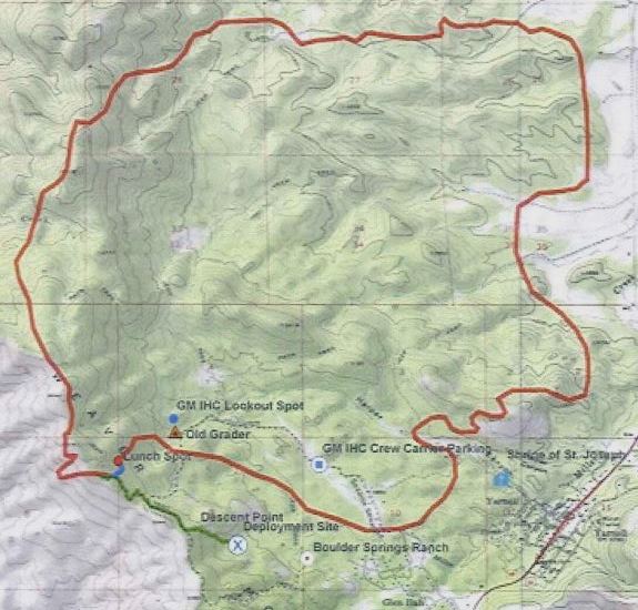
The map below shows the approximate location of the fire at 4:30 p.m. on June 30, 2013, about 15 minutes before the Hotshots were entrapped at the deployment site (X) on the south side.

Yarnell Hill Fire, estimated perimeter at 4:30 p.m. June 30, 2014
Yarnell Hill Fire, estimated perimeter at 4:30 p.m. June 30, 2014. Source: Arizona State Forestry Division.

Report released for 2013 smokejumper fatality

smokejumpers on the Hastings fire
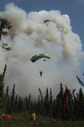
File photo of smokejumpers on the Hastings Fire, northwest of Fairbanks, Alaska, May 31, 2011. Photo by Mike McMillan/Alaska Fire Service.

The Bureau of Land Management has released an Accident Investigation Factual Report on the fatality of the smokejumper in Idaho last year. On September 27, 2013 Mark Urban was killed on a parachute jump while conducting an equipment evaluation at a remote airstrip outside of Prairie, Idaho, approximately 50 miles east of Boise.

Mr. Urban and other smokejumpers were collecting data during jumps to validate the vertical speeds and the activation window under which an automatic activation device (AAD) would initiate the opening sequence of either a main or reserve canopy in smokejumper operations. The AAD was not intended to be engaged during the jump and was not thought to be a factor in the cause of the accident. The parachute was to be manually opened.

All of his previous 287 jumps had been from approximately 3,000 feet above ground level (AGL), but the test on September 27 was designed to begin from the 6,000-foot level. The plan was to wait until reaching 3,000 feet AGL to deploy the main parachute. Similar tests had been conducted years earlier and several jumpers successfully executed the procedure earlier that day.

Mr. Urban’s parachute did not deploy until he was 138 feet AGL, which did not result in any significant deceleration. He was killed upon impact with the ground.

After leaving the Twin Otter aircraft, Mr. Urban, as did other jumpers that day, experienced some spinning while descending from 6,000 to 3,000 feet. The jumpers had been briefed on procedures to correct the spin, but while the exact cause of the accident may never be known, at least one of the investigators concluded that it is possible Mr. Urban spun fast enough to create G-forces that caused him to lose consciousness.

Below is an excerpt from the report in the Human Factors section. It was written by Randy McCalip, a LtCol with the U.S. Air Force, trained as a human factors/aerospace physiology expert and military free fall jumpmaster with 16 years of jumping experience.

…I believe the [Mishap Smokejumper] MS experienced enough initial G-force to cause visual, cognitive, and/or physical degradation delaying early necessary action. The MS channelized on fulfilling the T&E jump profile requirements exposing him to longer and higher G-forces resulting in a G-LOC. The GLOC caused the MS to lose all motor function and go limp. This reversed the MS’s spin and eventually slowed the spin enough to return blood flow to the brain. The MS regained consciousness and initiated pull sequence at 138 ft AGL, well below safe deployment altitude.
Gravitational forces were CAUSAL in this mishap.

F. HF Summary
I thoroughly reviewed all factors that possibly caused and contributed to this mishap. Although the team had eye witness testimonies and two different video angles of the mishap, exactly why the MS didn’t pull at the instructed altitude will never be known with 100% certainty. The MS was highly regarded as an exceptional leader and experienced smokejumper that paid attention to details and standards. This HF analysis attempted to piece together the most logical reasons why the MS failed to deploy his main parachute.