Escape from the Pagami Creek Fire

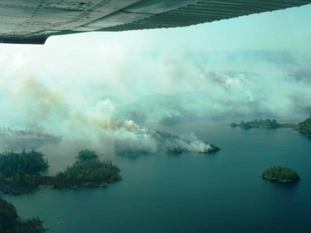
Pagami Creek fire, burns along lake shore
Pagami Creek fire burns along lake shore in undated photo by Superior National Forest

Outside Magazine has a riveting article about Greg and Julie Welch who had to flee in their kayaks as the massive wind-blown Pagami Creek Fire consumed tens of thousands of acres in the Boundary Waters Canoe Area Wilderness in Minnesota on a September day in 2011.

When lightning ignited the fire on August 18, the Superior National Forest made a decision to not suppress it, but to herd it around as necessary to keep it within a reasonable maximum management area while allowing natural processes to do their thing. After 12 days it had only grown to approximately 130 acres, and fire management officials may have thought things were going well — until September 12 when everything went to hell. Strong winds gusting at 35 mph or more spread the fire 16 miles to the east, ultimately burning over 92,000 acres by mid-October. HERE are some of the posts on Wildfire Today about the Pagami Creek Fire.

Greg Welch had been a photojournalist and often had taken photos of wildland firefighters as they suppressed fires, so when rangers told him about the Pagami Creek Fire, both he and the rangers thought their camping plans sounded reasonable, since the fire was miles away.

On the second day of their trip, the Welchs paddled their kayaks to another camping spot and set up their tent. Soon, and very unexpectedly, the fire was on them, and they hurriedly took some belongings to their kayaks and prepared to get out into the lake. Here is an excerpt from the Outside article:

…Julie was sitting in her kayak, watching her husband run down to the shore. Just as he came down the slope, the fire crested over the bank and roared just a few feet behind him. Greg threw the life jacket to Julie and told her to go while he strapped the last bags onto his kayak and dragged it to the water.

As Julie paddled out, everything suddenly went black as the fire pushed a thick cloud of soot and ash ahead of it. She couldn’t see Greg, so she screamed his name, but the noise of the fire was like standing next to a freight train. All she could see was thick smoke and burning trees falling in the water. For a few seconds, she thought Greg was lost, and that she was, too. She had no map, and no way to get back alone.

Then Greg appeared, paddling out of the smoke, a few feet away from her. But just as soon as she caught sight of him, the wind tossed her kayak into the air and flipped her into the cold water. By the time she surfaced, the boat had been blown far across the lake. Greg paddled toward her, but the wind was too strong—he couldn’t stop—and it blew him right past her. So he jumped in the water, holding his kayak and staying still, yelling for her to swim toward him. It took a few minutes for Julie to reach him, but together they clung to his boat while everything around them burned.

In addition to Greg and Julie Welch, eight U.S. Forest Service employees had near misses and entrapments on the fire. There is an  an excellent facilitated learning analysis about them being caught out in front of the rapidly spreading fire in canoes while trying to evacuate the recreating public from the area. At one point when they were fleeing the fire, the smoke was so thick they could not see the fronts of their canoes. Two people bailed out of a canoe to take refuge in the cold water, deploying a single fire shelter over their heads as they floated, suspended by their life jackets. Two others were flown out at the last minute by a float plane when the pilot somehow found a hole in the smoke and was able to find them, land on the lake, and extract them. Four people, after paddling furiously in the strong winds, dense smoke, and darkness, unable to find a fire shelter deployment site on the heavily forested islands, finally found a small, one-eighth acre barren island where they climbed inside their shelters as they were being pounded with burning embers.

Wildfire news, October 9, 2012

Another claim against the USFS for escaped prescribed fire in Montana

Another land owner has filed a claim against the U.S. Forest Service for the 2010 Davis prescribed fire that escaped on the Helena National Forest and burned approximately 450 acres of private land belonging to multiple owners. In June Wildfire Today told you about three land owners who are suing the government seeking unspecified damages and a jury trial.

The latest claim is from Andy Skinner, who is asking for $137,770 for damage to his property. He is also asking for $50,000 for the time it has taken for him to research the damage and file the claim.

The Davis prescribed fire northwest of Helena, Montana escaped on August 26, 2010 and burned over 2,000 acres of private and U.S. Forest Service land.

Wildfire Today covered the Davis Fire extensively in 2010, and summarized some of the coverage on November 22, 2010 after the U.S. Forest Service released their report on the incident. We highlighted some of the issues that led to the escaped prescribed fire.

Minnie fire may burn for weeks

The Minnie fire in northwest Minnesota near Fourtown, between Upper Red Lake and Lake of the Woods, has moved into areas containing peat, and is now burning deep underground in the organic soil, making it extremely difficult to suppress. Unless the area receives a great deal of rain soon, it will most likely burn for weeks, or longer.

Extraordinary photo of vehicle fire

A motorist that had to stop when a vehicle fire in Missoula closed a road, took some photos of the burning car. One of them captured the moment a vessel inside the car exploded, demonstrating why firefighters need to employ proper tactics on these fires, and why adequate personal protective equipment should be worn.

Wind-driven fire burns homes in Minnesota

County 27 fire
County 27 fire, photo by LOWFisherman

Update at 9 p.m. CT, October 3, 2012:

MNICS, the Minnesota Incident Command System, has provided more information about the County 27 fire near Karlstad and the Minnie fire near Fourtown.

County 27 fire:

The fire has burned 4,700 acres and is 5 percent contained. Despite the best efforts of firefighters, 4 residences, 7 mobile homes, 2 garages, and 22 outbuildings were lost.

Minnie fire:

This fire made made an 11 mile run to the northeast on Tuesday and is now approximately 24,700 acres. It had very active fire behavior on Tuesday in an area with unsecured line on the north side. Several trail and roads in the area were closed on Wednesday.

==================

Originally published at 12:04 p.m. CT, October 3, 2012

Strong winds in northwest Minnesota on Tuesday caused at least two fires to grow substantially, with one of them destroying half a dozen homes.

County 27 fire:

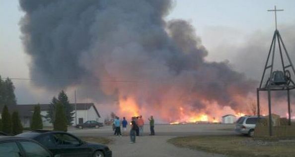
The County 27 fire burned into the south edge of the community of Karlstad. Much of the town was evacuated and six to eight homes were lost on the southwest side of the town, according to the Minnesota Incident Command System (MNICS). By Wednesday morning firefighters had stopped the spread of the fire.

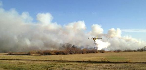
National Guard Blackhawk helicopters, a BAe-146 air tanker, and CL-215 air tankers assisted ground-based firefighters in suppressing the fire. Other smaller aircraft were grounded due to the strong winds, including light helicopters, single engine air tankers, and light fixed wing aircraft.

BAe-146 on the County 27 fire
BAe-146 on the County 27 fire, photo by LOWFisherman
CL-215 on County 27 fire
CL-215 on County 27 fire, photo by LOWFisherman

It is interesting that the area in which these fires burned was not covered by the red flag warning that was in effect for much of the state of Minnesota on Tuesday.

Other photos of the County 27 fire near Karlstad can be found at the Minnesota Public Radio web site.

The winds at the AGZM5 weather station Tuesday afternoon were measured at 15 to 26 mph with gusts up to 41, and the relative humidity bottomed out at 17 percent. During the night and on Wednesday morning the winds calmed down, blowing at 4 to 9 mph.

The map below shows the approximate location of the County 27 fire near Karlstad, according to heat detected by satellites. There are reports that the fire jumped U.S. Highway 59 and crossed Kittson County Highway 9, but did not move past Minnesota Highway 11.

Map of County 27 fire, Karstad, Minnesota
Map of County 27 fire near Karstad, Minnesota, October 3, 2012, showing heat detected by satellites. (click to enlarge)

Minnie Fire:

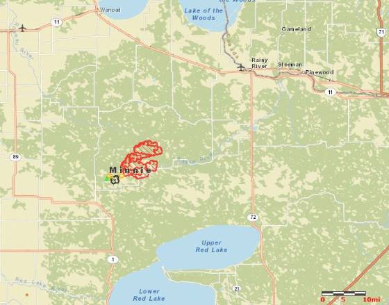
The Minnie Fire, near Fourtown between Upper Red Lake and Lake of the Woods, was 600 acres when the last report was filed on October 1 at 1 p.m., but Tuesday’s very strong winds caused it to spread approximately 8 miles to the northeast, adding, according to our rough estimate, an additional 25,000 acres.

Map of Minnie fire
Map showing Minnie fire, October 3, 2012

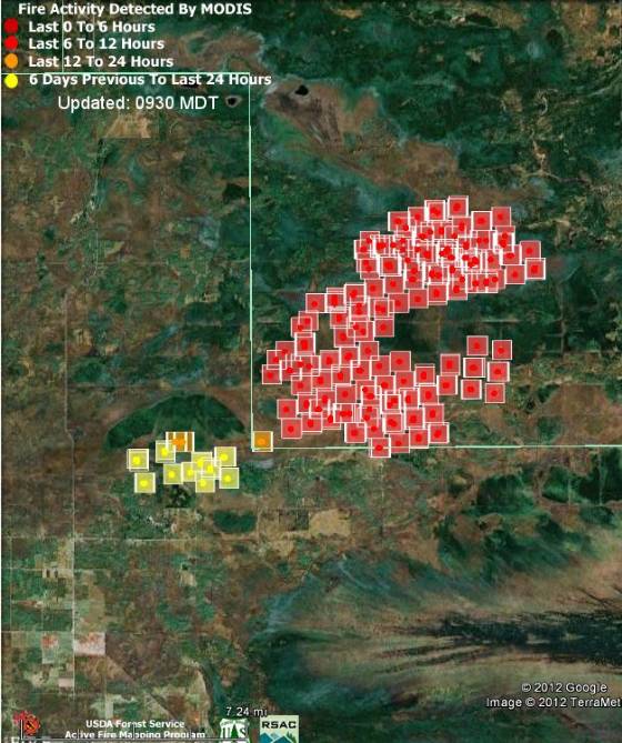
On the map of the Minnie Fire below, the red squares represent heat detected by satellites between 2:14 p.m. CT on Tuesday and 2:14 a.m. CT on Wednesday.

Map of Minnie fire
Map of Minnie fire, 2:14 am CT, October 3, 1012. MODIS, Google


Red flag warnings and record-breaking heat expected in California

A weather forecast for record-breaking triple-digit heat and single digit humidities has brought out a red flag warning for some areas in southern California for Monday and Tuesday. The temperatures are expected to be about 20 degrees hotter than normal,  between 95 and 105 at the lower elevations in the mountains of Los Angeles and Ventura Counties on Monday, then a few degrees cooler on Tuesday. Downtown Los Angeles is expected to hit 100 degrees on Monday, with it reaching 105 degrees in Burbank and Pasadena.

Northeast winds at 10 to 20 mph with 30 mph gusts are expected on Monday, with Tuesday afternoon bringing 25 mph onshore winds.

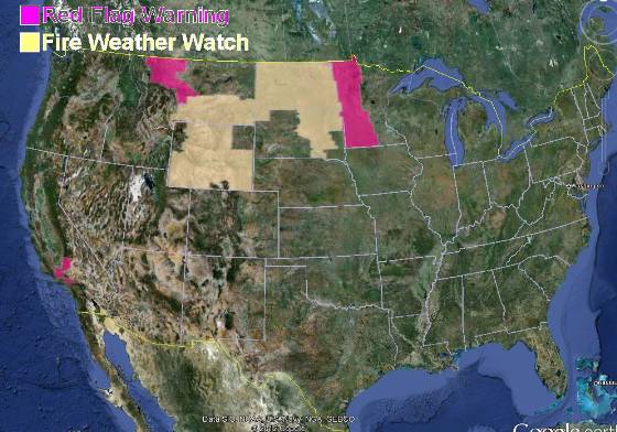
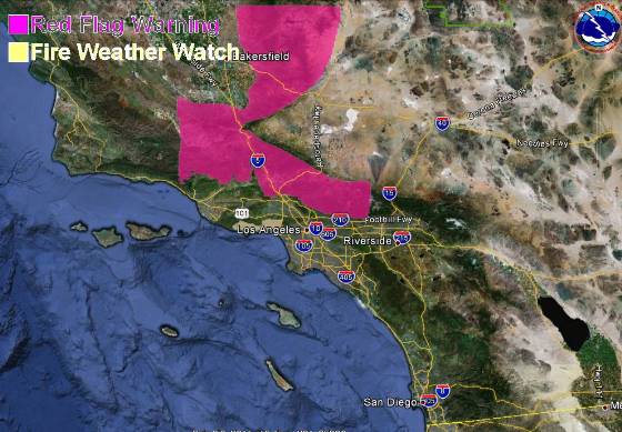
Red Flag Warnings, October 1, 2012

The map below shows the area in southern California covered by the red flag warning, which is in effect from 6 a.m. Monday until 6 p.m. PDT Tuesday.

Red Flag Warning, Southern California, October 1, 2012

There is also a red flag warning for some areas in northwest Montana for gusty winds and low humidities from 11 a.m. through midnight MDT on Monday. The winds are expected to be southwest at 15 to 25 mph with gusts up to 50, with the humidities as low as 16 percent.

The passage of a cold front has resulted in a red flag warning for western Minnesota from 2 p.m. until 7 p.m. CDT on Monday. Winds should be northwest at 20 with gusts up to 30 mph along with humidities as low as 20 percent.

A fire weather watch is in effect for areas in Wyoming, Montana, North Dakota, and South Dakota.

Reviews of Pagami Creek Fire, and FLA for canoe entrapments

The U.S. Forest Service has released two additional reports about last year’s Pagami Creek Fire which was managed, rather than suppressed, for 25 days, until it ran 16 miles on September 12, eventually consuming over 92,000 acres of the Boundary Waters Canoe Area Wilderness in Minnesota. We also remind you of the facilitated learning analysis of the eight USFS employees caught out in front of the fire in canoes.

Policy review

The objective of one of the reviews was to determine if the major decisions made by the incident management teams and the staff of the Superior National Forest were consistent with official USFS policy. The review was conducted by one person, Tom Zimmerman, a program manager for the USFS’ Wildland Fire Management Research, Development, and Application Program in Boise. Mr. Zimmerman analyzed the decisions and compared them with 21 policy statements, manuals, directives, and Forest level planning documents. He concluded that the decisions “appear consistent with all levels of policy and process direction”.

Decisions review

There was another review, “looking at decisions made by line officers and Incident Management teams based on the Delegation of Authority from the Forest Supervisor”. The individuals involved in this review were Jim Thomas, Fire and Emergency Operation Specialist for the Eastern Region of the USFS, and Jim Bertelsen, a Superior NF employee acting in his capacity as President of local NFFE Union 2138. This review also found no fault with how the fire was managed, saying no information was overlooked that would have predicted the unprecedented movement of the fire on September 12.

While we don’t dispute the qualifications of Mr. Zimmerman and Mr. Thomas, a person has to wonder if these internal reviews, each conducted basically by one person, would have reached different conclusions had they been completed by a panel of neutral subject matter experts.

Entrapment and near-miss facilitated learning analysis

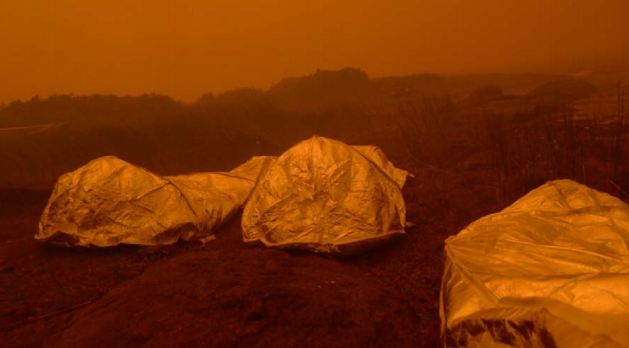
Pagami fire shelters
Deployed fire shelters on the Pagami fire. USFS photo from the facilitated learning analysis.

In addition to those two reviews, released earlier was an excellent facilitated learning analysis (FLA) of the near misses and entrapments of eight USFS employees who were caught out in front of the rapidly spreading fire in canoes while they were trying to evacuate the recreating public from the area. At one point when they were fleeing the fire, the smoke was so thick they could not see the fronts of their canoes. Two people left a canoe and took refuge in the cold water, deploying a single fire shelter over their heads as they floated, suspended by their life jackets. Two others were flown out at the last minute by a float plane when it somehow found a hole in the smoke and was able to find them and land on the lake. Four people, after paddling furiously in the strong winds, dense smoke, and darkness, unable to find a fire shelter deployment site on the heavily forested islands, finally found a small, one-eighth acre barren island where they climbed inside their shelters as they were being pounded with burning embers.
The very well done FLA is a must read. Someone should make a movie about this.


Thanks go out to Dick

Report released on Pagami Creek fire canoe overturn incident

File photo of canoe and float plane
File photo of canoe and floatplane. USFS photo

On October 16, 2011 during the Pagami Creek Fire on the Superior National Forest in northeast Minnesota an incident occurred that resulted in a motorized canoe being swamped in the middle of a large lake. As a result, three firefighters were totally immersed in cold water and exposed to hypothermic conditions for approximately 25 minutes until they were rescued by floatplane.

It occurred when a Division Supervisor and a Task Force leader were being ferried out to meet a Beaver (deHavilland) floatplane that was going to extract them.

Here is an excerpt from the facilitated learning analysis about the incident:
Continue reading “Report released on Pagami Creek fire canoe overturn incident”