A closer look at the Pagami Creek fire in the BWCAW

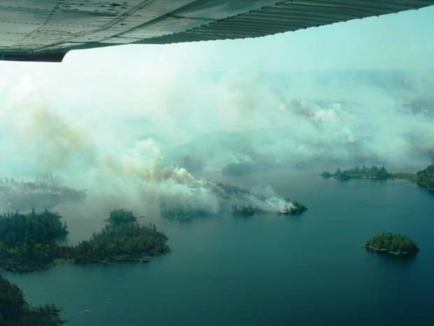
Pagami Creek fire September 11, 2011.
Pagami Creek fire September 11, 2011. Photo: Superior National Forest

The latest update on the Pagami Creek fire which has burned over 92,000 acres in Minnesota’s Boundary Waters Canoe Area Wilderness was on October 22. At that time it was described as 93 percent contained and unstaffed. The federal government has spent $22.3 million dollars on suppression as of October 22.
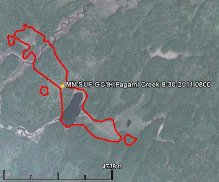
Map Pagami Creek fire 0800 8-30-2011
Map of the Pagami Creek fire at 8:00 a.m. CT, August 30, 2011. Credit: Superior National Forest and Google Earth

When lightning ignited the fire on August 18, the Superior National Forest made a decision to not suppress it, but to herd it around as necessary to keep it within a reasonable maximum management area while allowing natural processes to do their thing. After 12 days it had only grown to approximately 130 acres, and fire management officials may have thought things were going well — until September 12 when everything went to hell. Strong winds gusting up to 35 mph spread the fire 16 miles to the east. HERE are some of the posts on Wildfire Today that mention the Pagami fire.

The StarTribune has a probing article written by Tony Kennedy that explores some of the decisions that were made during the early stages of the fire. It’s worth a read. Here is an excerpt:

===============================================================

Forest Service way off on BWCA fire projections

Records show the federal agency repeatedly underestimated the fire’s strength and volatility.

ELY, MINN. — A series of internal reports show that the U.S. Forest Service repeatedly underestimated the explosiveness of the Pagami Creek Fire during a critical 18-day stretch of late August and early September, allowing a half-acre burn to grow into a massive firestorm that left eight people fighting for their lives inside the Boundary Waters Canoe Area Wilderness.

[…]

“We felt like we were being very proactive,” said Mark Van Every, head of the Kawishiwi Ranger District in Ely, where the fire command is based. “It just happened faster and further than we expected.”

In the future, he said, the Forest Service might order faster and wider evacuations. “I will make those closure areas broader if I feel there is any potential at all that the fire could get there,” Van Every said. He said officials will also recalibrate the tools used to judge how fast a BWCA fire can move.

Meanwhile, two public reviews are underway. One is focused on an incident that endangered six crew members trapped by fire on Lake Insula. Two female crew members were forced to abandon their canoe while paddling in a lake channel that became choked by fire, Van Every said. Four others beached their canoes on an island and took cover under life-saving gear and later rescued their freezing crewmates from a nearby shore.

[…]

The half-acre burn didn’t budge much for seven days. The U.S. Drought Monitor, produced by the National Weather Service, showed the area to be in the first stage of drought, known as “abnormally dry.” But Van Every and Tim Sexton, a forest ranger based in Cook, Minn., said other indicators didn’t suggest rapid rates of spread. The fire’s early behavior supported that thesis, they said.

Then, on Aug. 26, with Sexton covering for a vacationing Van Every, the humidity level dipped abnormally to 18 percent and winds blew from the northwest. What had been a slow-creeping fire with flames 6 inches high in the morning picked up and ran in a narrow band to the southeast.

[…]

Strategic burn

The Sept. 4 decision reflected firefighters’ growing concern about dry forest conditions. “Weather forecasts indicate that September will experience dry, windy weather with occasional frosts (which will cause leaf fall and add to the hazardous fuel loading),” the WFDSS report said. In addition, drought conditions would worsen to the “severe” level by Sept. 6.

Local criticism of management of Pagami Creek fire

Pagami fire, Lake Polly 9-12-11 Hans Martin USGS
Pagami Creek fire, burning near Lake Polly, 9-12-2011. Photo: Hans Martin, USGS

When lightning ignited the Pagami Creek fire in the Boundary Waters Canoe Area Wilderness on August 18, the Superior National Forest made a decision to not suppress it, but to herd it around as necessary to keep it within a reasonable maximum management area while allowing natural processes to do their thing. After 12 days the fire burning in the northeast corner of Minnesota had only grown to approximately 130 acres, and fire management officials may have thought things were going well — until September 12 when everything went to hell. Strong winds gusting up to 35 mph spread the fire 16 miles to the east. And now, $5.7 million and 93,000 acres later, you have the third largest fire in the history of Minnesota, meteorologists are tracking the smoke as it passes over China, and the local newspaper, the Ely Echo, has written a scathing editorial criticizing the decisions the U. S. Forest Service made.

I spent a lot of time on specialized “fire use” incident management teams managing these types of fires. It IS possible to manage a fire, herding it around, without fully suppressing it. But there are dozens of variables that have to be scrutinized by extremely knowledgeable, experienced, smart people to pull it off successfully. Something in the equation was missing on the Pagami Creek fire, and it just points out how difficult a limited suppression strategy can be to perfectly execute over a period of weeks or months. Sometimes you make good decisions or you are lucky, and the weather makes the team and the agency look good. Other times, mistakes in judgement are made and the weather blows them up into a hundred thousand black acres, and smoke columns are tracked across China.

Thanks go out to Chuck and Mary


Smoke from Pagami Creek fire detected over eastern Europe today

Pagami Creek fire smoke over eastern Europe, 0500 UTC 9-16-2011
Smoke from the Pagami Creek fire over Poland, Ukraine, and Russia at 0500 UTC 9-16-2011. Meteosat-8, HRV

Smoke from Minnesota’s Pagami Creek fire is being tracked by meteorologists and other scientists as it travels around the globe.  At 0300 UTC September 15 it was detected over the United Kingdom at a height of 11 to 12 kilometers, which is above the cold point tropopause. The satellite photo above shows it over Poland, Ukraine, and Russia at 0500 UTC September 16.

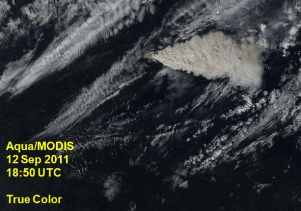
Pagami Creek fire smoke over US 1850 UTC 9-12-2011
Smoke from the Pagami Creek fire being generated in Minnesota at 1850 UTC, September 12, 2011

It has only been in recent years that scientists have realized that smoke from wildfires can not only be transported from one continent to another, but the smoke “clouds” can remain relatively intact and circle the Earth for months. Chuck Bushey, a long-time fire behavior analyst and currently the President of the International Association of Wildland Fire, wrote this in an email today:

The “cloud” from these events that penetrate upper levels of the troposphere and even lower stratosphere have been shown repeatedly to hold together for extended time periods – circling the globe as distinct atmospheric entities before finally dissipating sometimes months after the initiating event. Not only is the immediate fire behavior of these events unusual and interesting but so are the longer term results and I believe the potential implications.

We wrote about this phenomenon in an article on October 22, 2010, and we copied it below:
Continue reading “Smoke from Pagami Creek fire detected over eastern Europe today”

Minnesota: Pagami Creek fire mapped at 100,000 acres, evacuations ordered

A fire that started in the Boundary Waters Canoe Area Wilderness (BWCAW) and was not suppressed for about two weeks, has burned outside the BWCAW and become the largest fire in Minnesota since 1918. The Pagami Creek fire has burned 100,000 acres, according to the incident management team, and forced evacuations on the south and east sides of the fire. Scroll down to see maps of the fire.

It started from a lightning strike on August 18 and by August 30 had burned approximately 130 acres.

Map Pagami Creek fire 0800 8-30-2011
Map of the Pagami Creek fire at 8:00 a.m. CT, August 30, 2011. Credit: Superior National Forest and Google Earth

The staff at the BWCAW and the Superior National Forest decided to monitor it and allow natural processes to run their course. They conducted some firing operations, burning an additional 2,000 acres, to herd the fire away from populated areas on the north and west sides, but by last weekend it was obvious that they needed to suppress it. Strong winds on Monday of 15-20 mph gusting up to 35 mph spread the fire 16 miles to the east. At that point the intensity of the fire far exceeded the capabilities of the fire suppression forces. Winds again on Tuesday spread the fire even further, to the point where it is now mapped at 100,000 acres. However the smoke makes mapping difficult, and that acreage may change after firefighters can actually see the full perimeter.

The Pagami Creek fire is ranked as the third largest fire in the history of Minnesota. Larger fires were the 250,000-acre fire near Cloquet in October of 1918 which killed 559 people, and a 200,000-acre fire near Hinckley in September of 1894 which killed 418 people. Here is a link to more information about “Infamous Fires”.

The maps below show what it looks like now:
Continue reading “Minnesota: Pagami Creek fire mapped at 100,000 acres, evacuations ordered”

Minnesota: strong winds spread the Pagami Creek fire 16 miles to the east

Pagami Creek fire September 11, 2011.
Pagami Creek fire September 11, 2011. Photo: Superior National Forest

=================

UPDATE AT 12:48 p.m. CT, September 14, 2011:

Updated information about the Pagami Creek fire.

=================

UPDATE at 10:53 p.m. CT, September 13, 2011: The InciWeb site for the Pagami Creek fire was updated about an hour ago, and includes a new figure for the size of the fire: 100,000 acres. Maps of the fire can be found on the InciWeb site…if it is up and running. It had problems off and on today.

==================

Monday morning the Pagami Creek fire in Minnesota’s Boundary Waters Canoe Area Wilderness (BWCAW) east of Ely was 11,000 acres. Today I saw a map that was updated at 7:00 p.m. Monday night. From my very unofficial estimate derived from counting 640-acre sections that had burned, the fire had blown up to over 70,000 acres. The maps may be an overestimate of the fire’s size; mapping it was difficult due to the smoke. Here is a link to a different, but current as of Monday night, map of the fire.

The Associated Press is reporting 60,000 acres, a figure which apparently came from Minnesota Interagency Fire Center spokeswoman Jean Bergerson Tuesday morning. InciWeb, which at times has been having problems today, was updated at noon on Tuesday with this information:

Yesterday, a finger of the Pagami Creek Fire made an unprecedented 16 mile run to the east, reaching the edge of Polly Lake. The fire became a plume-driven event and reached in excess of 60,000 acres. Residents were evacuated from 36 addresses along the portion of the Cramer Road/Lake County Road 7 from Kawishiwi Lake south to the Wanless Road (Forest Road 172) and along the Wanless Road west from the junction with the Cramer Road to Homestead Lake. Winds are expected to be strong and out of the northwest and west again today with little or no precipitation expected.

Pagami Creek fire, burns along lake shore
Pagami Creek fire, burns along lake shore in undated photo by Superior National Forest

The blowup was caused by 15-20 mph west and northwest winds on Monday that gusted up to 35 mph pushing the fire approximately 16 miles to the east. The National Weather Service is predicting strong northwest winds again on Tuesday of 18 mph gusting to 28 along with a relative humidity of 37%. But between 2 and 6 p.m. there is a 45 percent chance of showers. Tuesday’s high temperature will be 60 in Ely, but on Wednesday it will cool off quite a bit with a high of only 46, with winds of 14 mph gusting to 18.

Check out this animation of smoke from the fire as seen from a satellite on September 11. And HERE is an excellent gallery of pictures of the fire…taken from the ground.

The Pagami Creek fire is the largest in the state since the Ham Lake fire burned over 76,000 acres in Minnesota and Ontario in May 2007, destroying 163 structures near Gunflint Trail.

Doug Turman’s Type 1 Incident Management Team has been dispatched to the fire and will assume command at 6:00 p.m. on Tuesday. Maybe his team will have better luck obtaining firefighting resources. Here is an excerpt from an article posted Monday night in the Lake County News-Chronicle (you may need to register to view the site):
Continue reading “Minnesota: strong winds spread the Pagami Creek fire 16 miles to the east”

Minn.: Firefighter dies on the way to a grass fire


PINE CITY, Minn. — Pine City firefighter Jeremy Jylka, 34, died Tuesday afternoon en route to a grass fire.

According to the Pine City Sheriff’s Office, Jylka collapsed while riding in the fire truck on the way to a fire between Hinckley and Pine City. Jylka stopped breathing and another firefighter started to perform CPR.

Jylka, 34, was pronounced dead at Kanabec Hospital. He joined the fire department in 2007 and is survived by his wife, Kelly and their 4-year-old daughter, Anica.


From MyFox Twin Cities