Wildfire briefing, June 13, 2014

(Originally published at 9:19 a.m. CT, June 13, 2014)

House teetering on cliff to be prescribed burned
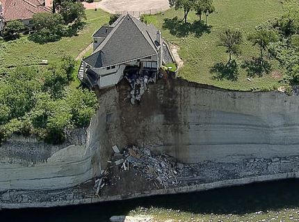
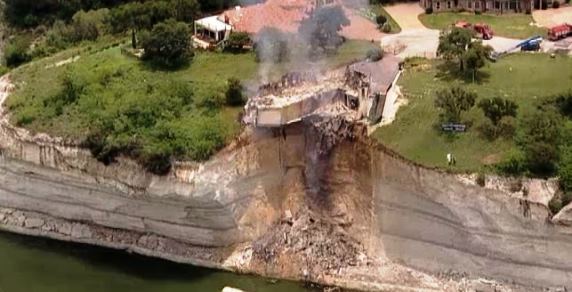
House above lake
NBCDFW photo.

A house at the top of a cliff over Lake Whitney in Texas will be burned intentionally Friday morning. The cliff below part of the house has fallen away, leaving the house precariously teetering. The house will be burned, which is considered a better option than allowing it to fall into the lake where the debris would have to be removed.

A crew is prepping the house by breaking out windows and adding bales of hay soaked in diesel fuel to the interior.

The prescribed fire is being covered live by a television station in Texas.

(UPDATE at 10:15 a.m. CT, June 13, 2014)

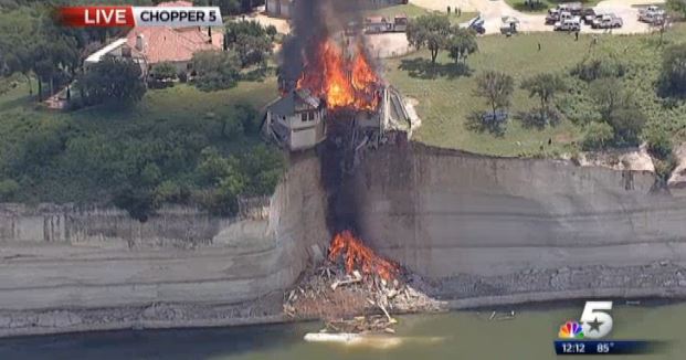
Ignition has begun. Firefighters are on scene applying water between the burning home and a nearby house, perhaps to minimize damage to a couple of trees.

House above lake burning

(UPDATE at 11:36 a.m. CT, June 13, 2014)

It’s pretty much over:

House above lake burning House above lake burning

The photos are from NBCDFW.

Funeral services for Nevada firefighter

The funeral services for Donovan Artie Garcia Jr. will be held today, Friday, June 13. Mr. Garcia, the Assistant Chief of the Hungry Valley, Nevada fire department, died of a heart attack while participating in wildland fire training June 5. Services will be in Reno at 11 a.m. at the Hungry Valley Gymnasium, 9070 Eagle Canyon Drive.

MD-87 air tanker makes first drops

Erickson Aero Tanker’s two MD-87 air tankers, T-101 and T-105, made numerous drops on the Two Bulls Fire near Bend, Oregon shortly after they became certified and reported for duty. Wallowa.com has an article in which they quote pilot Brent Conner:

“I mean, I always wanted to be flying propeller planes, so this is new for me, and for most of us in this business,” he said.

“We can hold it in check, as we did with this fire, for about two days with retardant,” he said. “That gave them enough time to get the other flank taken care of.”

While it’s a job he’s done countless times before, it was Conner’s first weekend in real wildfire action with the Aero Tanker.

“It was a little nerve-wracking, actually,” he said. “We hadn’t been on a fire yet, the fire’s only 15 miles away. We barely had time to get the airplane cleaned up and we were already putting the flaps down, slowing down and getting ready to go.”

More information about the MD-87s is at Fire Aviation.

Reward for information about Two Bulls Fire

And speaking of the Two Bulls Fire at Bend, Oregon, the reward for information leading to a conviction of the person or persons responsible for setting the 6,908-acre fire has increased to $31,500. Anyone with information that could help identify suspects in the fire is asked to contact the Crime Stoppers Tip Line at 1-877-876-8477 (TIPS).

Hot pink may be the new color of fire retardant

The Missoula Technology Development Center is testing new colors for the fire retardant that is dropped by air tankers and helicopters. Below are excerpts from KPAX:

Over the last three years, some pilots have been complaining that the bright orange retardant is hard to see. “Particularly in late season when we’ve got grasses and trees that start turning color,” said Zylstra. With that concern, researchers at the US Forest Service’s Technology and Development Center in Missoula began looking into a solution, potentially a hot pink colored slurry. “So we run a product through a variety of different tests in our lab before it’s used out in the field,” said Zylstra.

[…]

The first batch of the hot pink slurry will be tested at four air tanker bases in California in regions predicted to have busy firefighting season.

Helitack crews train in Idaho

MagicValley.com has an article about U.S. Forest Service and Bureau of Land Management helitack crews training for the upcoming wildfire season.

Austin, Texas to get wildfire detection system

The Austin City Council voted to purchase a system of sensors mounted on towers that can detect smoke. The approval will allow the installation of two towers which will be tested for a year. At the end of the year they may decide to expand the system. In 2013, West Lake Hills, a community near Austin, also approved the acquisition of a similar system. It can detect smoke within 6 miles by rotating their sensors, completing a 360-degree rotation every 8 to 12 minutes, during which it takes images, analyzes, and then transmits those images for secondary analysis. If possible fire events are detected, the system alerts fire authorities.

Hotshots assist with prescribed fire on military base

The Laguna Hot Shots, based at Descanso, California, helped conduct a prescribed fire at Marine Corps Air Station Miramar on Thursday north of San Diego. Below is an excerpt from an article at 10News:

As a formation of Marine FA/18’s passed overhead to land at MCAS Miramar, members of the Laguna Hotshot crew were setting fire to the east side of the base.

The prescribed burn, as it’s called, is part of an annual brush management system put in place after the 2003 wildfire.

“After it burned more than 17,000 acres, the Cedar Fire really opened our eyes to a strong brush management program at the air station,” said Miramar Fire Operations Chief Paul Thompkins.

Construction begins on firefighter memorial in Prescott

Construction has started on a memorial in a cemetery in Prescott, Arizona for the members of the Granite Mountain Hotshots that were killed while fighting the Yarnell Hill Fire on June 30, 2013.

Below is an excerpt from KJZZ.org:

Construction is starting on a cemetery memorial for 19 firefighters killed in the Yarnell Hill wildfire, nearly a year after the fire started near Prescott. Each firefighter will have a plot and a bronze grave marker at the state-owned Pioneers’ Home Cemetery in Prescott. The plots are surrounded by a two-foot wall where mourners can sit.

Officials say 10 of the Granite Mountain Hotshot firefighters are already buried there. They say there’s room for family members to be buried alongside them.

The state designated a new section of the cemetery for the hotshots and charged $100 per grave site, instead of the usual $900.

 

Two Bulls Fire requires relocation of wedding

(UPDATE at 8 p.m. PT, June 8, 2014: After posting the photo and the description that was on Instagram, we heard from the managers of the facility where the wedding took place. We added more details below Mr. Newton’s description.)

****

On Saturday, June 7, a wedding about three miles east of the Two Bulls Fire near Bend, Oregon had to be evacuated just before the bride walked down the aisle.

Below is the description of the above photo on Instagram, which was taken by Josh Newton:

****

“Rock Springs Ranch Weddings, Bend OR
Yesterday’s wedding is definitely one for the books. About 11am, a small brush fire turned into a giant wildfire about 6 miles from the ceremony site. The wedding was at 4, and everyone was setup. Right as the bride was about to walk down, a firetruck came in sirens blaring and told the bride we had to evacuate. In tears, her father announced to all the guests that we had to move the wedding. Incredibly, the fireman then told us we could have the ceremony and then had to leave. I’ve never seen anything like what happened next. Everyone moved the entire wedding to a park in Bend, all with smiles and good attitudes. It showed everyone at the wedding what really mattered – the people and the couple. The location change didn’t affect the wedding at all, it was the most beautiful day. In planning my own wedding, it was an incredible reminder to really value and cherish the most important things in life. While the guests, caterers, and DJ all moved to Drake Park and setup, we snuck away and got some of the most incredible wedding photos I’ve ever taken. This is just with my phone, but can’t wait to show you all the rest.”

****

The rest of the story

As we said in the update above, after posting the photo and Mr. Newton’s description we heard from Kelly Louden of the Rock Springs Ranch near Bend, Oregon, the venue for the wedding. Much of their time at the ranch between June and October is spent planning and hosting weddings at their facility.

Ms. Louden told us that the bride had actually started to walk down the aisle when a white fire vehicle drove up with its siren going. The driver, presumably a firefighter since he had on a yellow shirt, told the wedding party that they had to evacuate immediately because of the threat from the Two Bulls Fire. The bride explained that they were just beginning a wedding. The firefighter then excused himself and talked on his radio for a few minutes. He came back and said the ceremony could go on, but then they would have to leave.  — there would be no time for a reception at that location.

After a shortened 15-minute version of the ceremony, everyone at the wedding, the friends, family, caterers, and DJ began throwing stuff into their cars and trucks. Everything needed for the reception had to go, including food, dishes, utensils, furniture, beverages, the cake, gifts, DJ equipment, speakers, flowers and decorations. The caterer had an idea about an alternative location in a park in Bend, and while the relocation was getting underway, Josh Newton, the photographer, took the bride and groom aside and shot a lot of what he described above as “some of the most incredible wedding photos I’ve ever taken”. Josh, by the way, is a professional photographer based out of Santa Barbara, California, and takes assignments all over the world. The photo above was taken with his cell phone, but he no doubt has hundreds of photos taken at the wedding with real cameras to sort through and post process.

They all went to the park where they reassembled the wedding. It turned out to be a very positive experience for everyone. And they all now have a story to tell.

****

UPDATE June 10, 2014: the photographer, Josh Newton, posted more photos of the wedding.

More information about the Two Bulls Fire west of Bend, Oregon.

Oregon: Two Bulls fire west of Bend

(UPDATE at 1:40 p.m. PT, June 11, 2014)

The Incident Management Team reports that the Two Bulls Fire has not grown over the last 24 hours with the exception of a small 1/4 acre spot fire that was detected and suppressed outside the main perimeter. The fire is listed at 6,906 acres and 40 percent containment. This will be our last update unless the status of the fire changes dramatically.

****

(UPDATE at 8:20 a.m. PT, June 10, 2014)

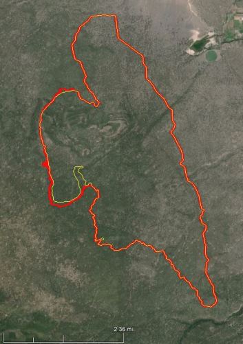
Map of Two Bulls Fire
Map of Two Bulls Fire. The yellow line was the perimeter on June 8. The red line was 24 hours later, at 11 p.m. PT, June 9, 2014.

The Two Bulls Fire three miles west of Bend, Oregon grew by about 100 acres on Monday, bringing the total number of burned acres to approximately 6,900. All of the spread was on the west side of the fire. Fire managers said they have a fire line around the east and south sides, while line construction continues on the west side.

Evacuation notices are still in effect for 50 homes. No structures have burned in the fire.

Investigators located the points of origin of the two fires that burned together to form what became the Two Bulls Fire. They collected evidence and announced that the blazes were human caused. Cascade Timberlands has put up a $2,000 reward for information that leads to a successful conviction.

****

(UPDATE at 8:55 a.m. PT, June 9, 2014)

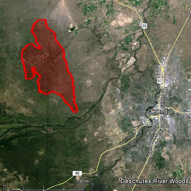
Map of Two Bulls Fire at 9 p.m. PT June 8, 2014

Finally we have a good map, above, of the Two Bulls Fire three miles west of Bend, Oregon. Fire officials said the latest mapping puts it at 6,800 acres. Firefighters have completed a fireline around the east and south sides, but they are only calling it five percent contained.

Below is an excerpt from information provided Monday morning by the Incident Management Team:

Good progress was made both yesterday during the day and night with firefighters taking advantage of some calmer weather conditions. The priority of securing fireline around the eastern and southern portions of the fire was met and it is anticipated that hoselines will be put into place along that line by the end of today with some mop-up activities commencing there. Some of the available crews from the east flank divisions were reassigned to the western flank of the fire today to help in securing fireline on that portion. Structure protection task forces mobilized under the Oregon State Conflagration Act continue to work around the threatened structures and have contingency plans in place to help protect the watershed facilities if the fire jumps containment lines.

TWITTER: @twobullsfire,

Dry weather conditions will continue to keep temperatures in the upper 70’s and lower 80’s and relative humidity dipping below 20%. The main concern for today will be hold the lines on the southern portion of the fire and out of the City of Bend’s watershed, as winds are forecasted to get gusty from the northwest at 10-18 mph in the afternoon as a weak upper level disturbance moves over the area.
• 6,800 acres consisting of heavy brush and timber
• 250 homes threatened with 50 remaining under Level III Evacuation
• No structures lost or damaged
• No injuries
• Cause under investigation
• 5% containment
• 11 helicopters, 46 engines, 11 dozers, and 708 personnel assigned to the fire
• Estimated costs to date- $1.23 million Public Information Meeting
An informational meeting open to all public and media will be held Monday evening at 6:00 pm at Bend High School, located at 230 NE 6th St in Bend. Fire representatives will give a current and expected fire briefing and will be available to address questions and concerns.

The Bend Bulletin has an interactive map showing the evacuation areas.

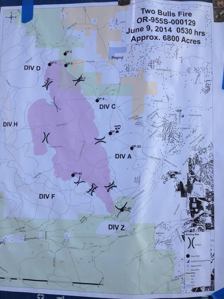
Two Bulls Fire map
Two Bulls Fire map 6-9-2014, used for briefing firefighters. Photo by George Ponte, ODF.

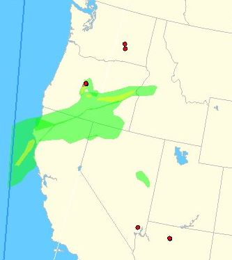
Map of smoke created by the Two Bulls Fire:

Smoke from Two Bulls Fire, at 9:51 a.m. PT, June 9, 2014

The video below is a time-lapse of the fire burning at night

On FireAviation.com is a video of air tankers taking off at Redmond, OR en route to drop retardant on the Two Bulls Fire.

Continue reading “Oregon: Two Bulls fire west of Bend”

Wildfire briefing, May 7, 2014

Cause determined for southern California wildfire

Investigators found that the cause of the Etiwanda Fire that burned over 2,000 acres east of Los Angeles last week was an illegal campfire. The Colby Fire that burned almost 2,000 acres in January east of Los Angeles near Glendora was also blamed on an illegal campfire.

Report released for fatality on Grassy Mountain Fire

The Wildland Fire Lessons Learned Center has posted the factual report for the fatality of a dozer transport operator on the Grassy Mountain Fire August 10, 2013 southeast of Rome, Oregon.

Report: firefighter kills intruder

The Christian Science Monitor (CSM) is reporting that a firefighter shot and killed an intruder in the firefighter’s garage. The victim was Diren Dede, a 17-year old German exchange student, which has stirred up interest in the case overseas.

Prosecutors have charged 29-year old Markus Kaarma with homicide.

The CSM referred to Mr. Kaarma as a U.S. Forest Service firefighter. The Missoulian in two different articles referred to him also as a U.S. Forest Service firefighter, and then later as a “former firefighter”.

An excerpt from the CSM:

Kaarma’s live-in girlfriend told neighbors that someone had stolen marijuana from the firefighter’s garage stash on several occasions. Investigators say they removed a glass jar full of pot during the course of their investigation.

An open question is whether a jury will believe police allegations that Kaarma set a trap for Diren by opening the garage door and linking up a baby monitor feed before shooting blindly into the darkened garage after spotting movement.

Brush fire related deaths in Iowa hospitals

Officials in Iowa are concerned about the number of brush fire related deaths in Iowa hospitals recently. Between February and April this year, the University of Iowa Burn Treatment Center reports three people have died and three others have been injured as a result of brush fires.  During that same time period last year, 2013, the Burn Treatment Center reported one death and one injury from burns sustained in brush fires.  All four deaths were of people ages 75 years and older. Not all of the victims were Iowans; some were flown in from surrounding states.

Woman found dead in Omaha brush fire

Firefighters suppressing a brush fire in Omaha, Nebraska late Tuesday night found a deceased woman in the fire area near 14th and Mason. She has been identified as  30-year old Amanda Brown, who had been in and out of a homeless shelter in recent years.
Thanks and a hat tip go out to Ken.

USFWS prescribed fire in Oregon

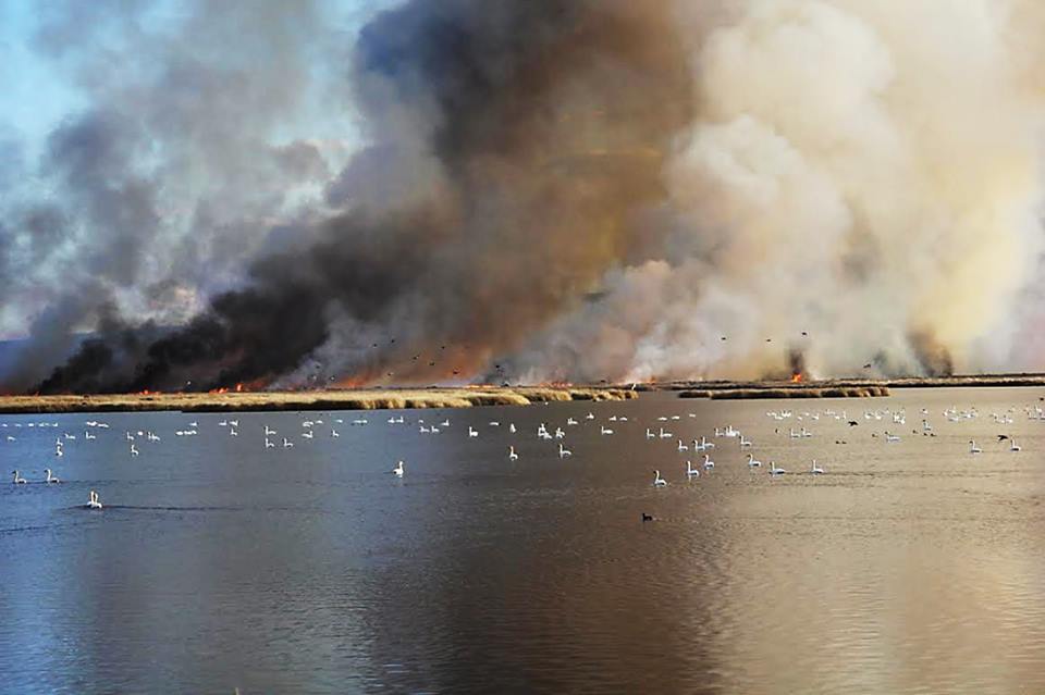
Rx fire at Malheur Nat'l wildlife Refuge. USFS photo by Shane Theall.
Rx fire at Malheur Nat’l wildlife Refuge. USFS photo by Shane Theall.

According to the U.S. Fish and Wildlife Service. their….

Malheur Fire Program and the Burns Interagency Fire Zone conducted a 2,250-acre prescribed fire on the Deer Park Unit of Malheur National Wildlife Refuge this week. Located in southeastern Oregon’s high desert, at the northern end of the Great Basin, the 187,000-acre National Wildlife Refuge is famous for its spectacular concentrations of wildlife. With its abundant water resources in an otherwise arid landscape, the Refuge hosts more than 320 bird species and 58 mammal species.

Rx fire at Malheur Nat'l Wildlife Refuge. USFWS photo by Carla Burnside.
Rx fire at Malheur Nat’l Wildlife Refuge. USFWS photo by Carla Burnside.

Rare winter fires in the Oregon Coast Range

Wildfire Heat detected in Washington and Oregon by a satellite
Heat detected in Washington and Oregon by a satellite at 1:08 p.m. PT, January 24, 2014

Rare winter fires are burning in Oregon’s Coast Range in areas that would normally be cold and wet much of the year, but especially in January. They are not huge, but some fires in Washington and Oregon are large enough to be detected by a satellite as you can see in the image above.

Below is an excerpt from KGW:

ARCH CAPE, Ore. — Rare winter wildfires in the Oregon Coast Range, visible from as far as 20 miles away, continued to burn early Friday morning east of Arch Cape.

The first was reported about 3 p.m. Thursday and second one about midnight south of the original fire, according to Seaside police.

Because it has been so dry and the wind has blown so hard early this winter season, forestry officials believe smoldering slash piles from the fall roared back to life and became new, bigger fires.

The fires, called Falcon and Shingle, were burning about 120 total acres Friday afternoon. A flight restriction was put in the place around the fires.

Gusts that reached an estimated 70 mph had flames jumping logging roads. At least 120 people were involved in the firefighting efforts by early Friday morning, including crews from Cannon Beach, Seaside, Gearhart, Nehalem departments and the U.S. Forest Service.

Thanks and a hat tip go out to JW and Steve