Wildfire potential to increase in the Northwest in August and September

Wildfire potential is expected to be above normal this Fall in the Southeast

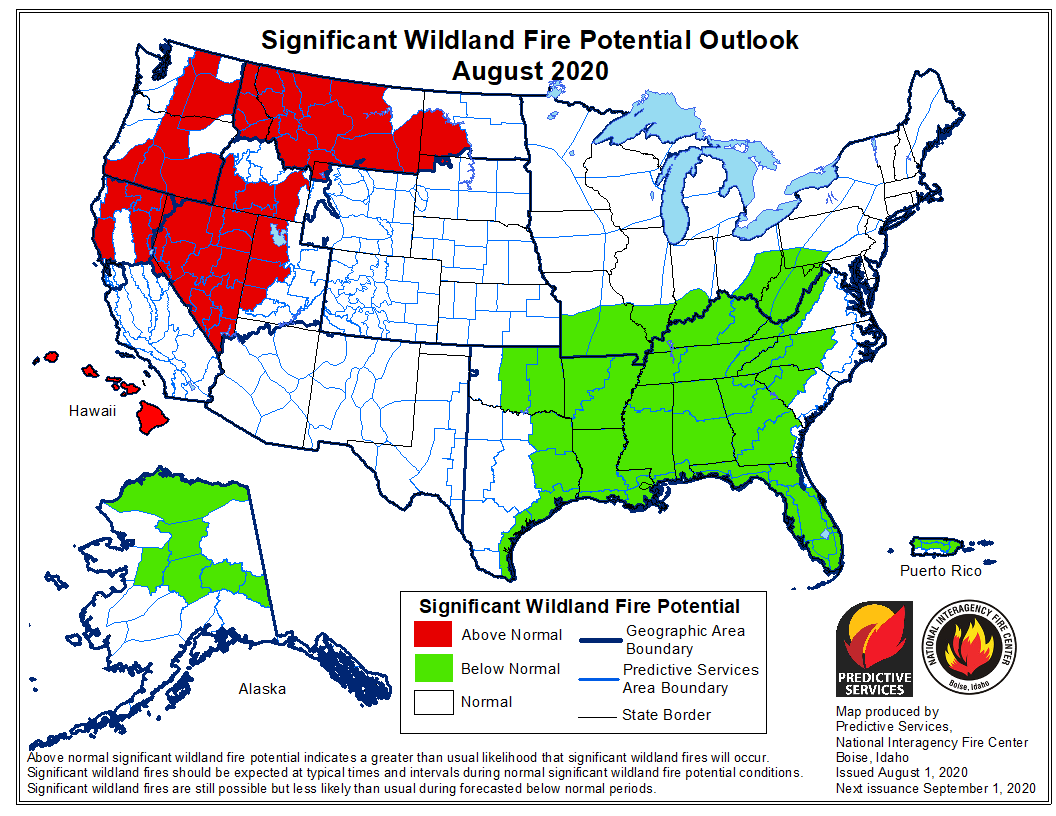
wildfire potential August

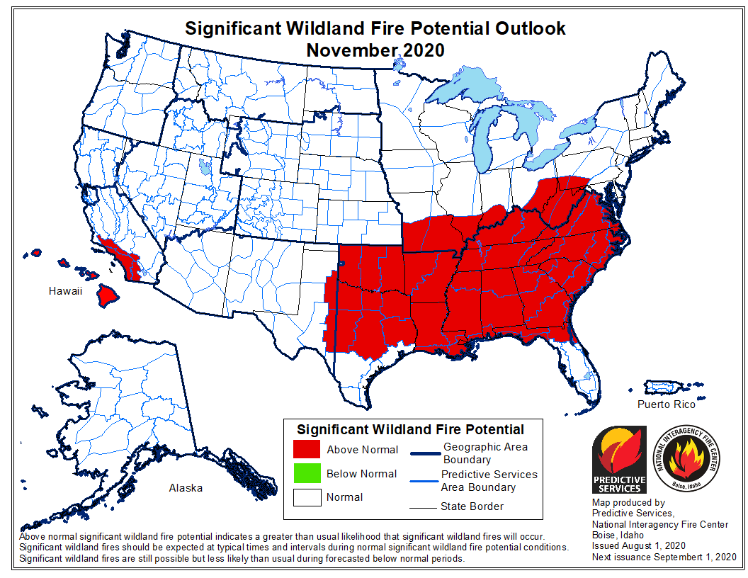
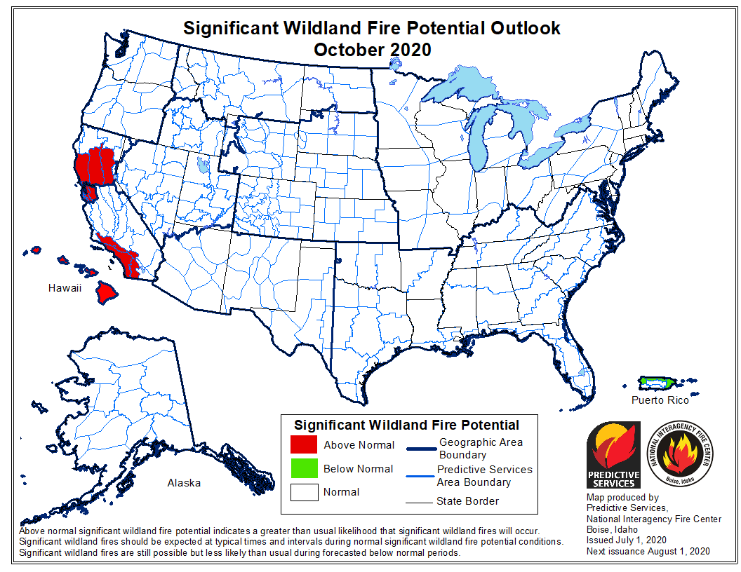
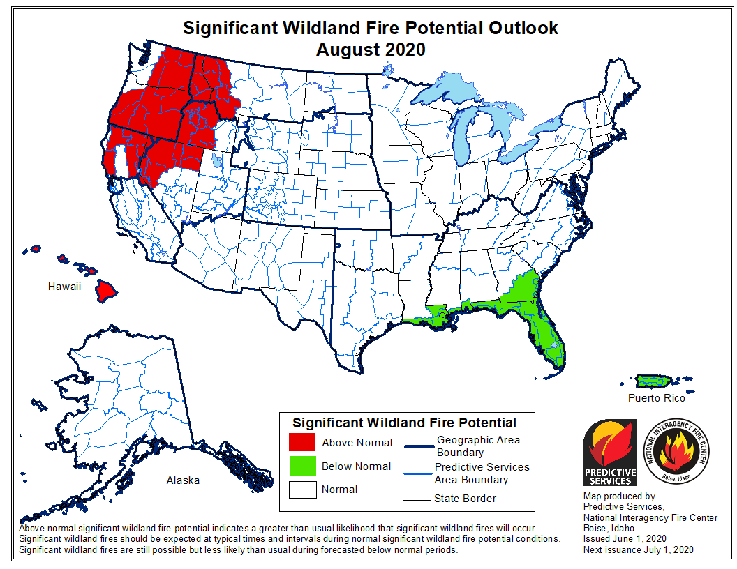
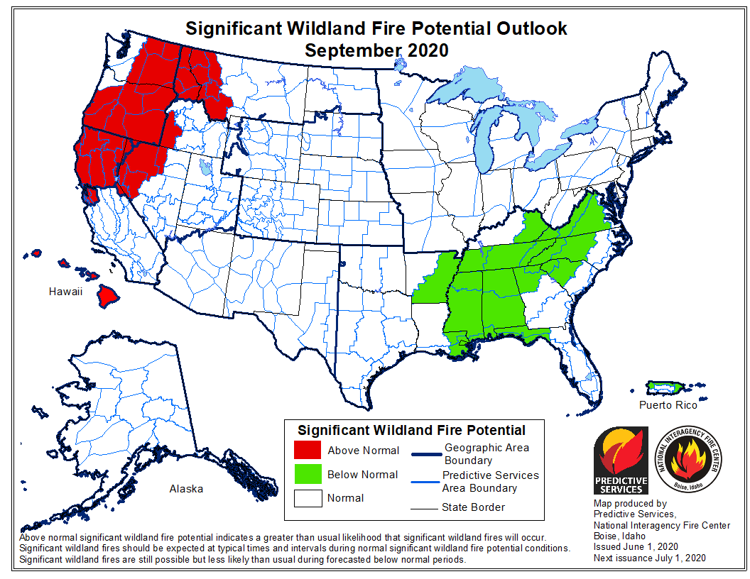
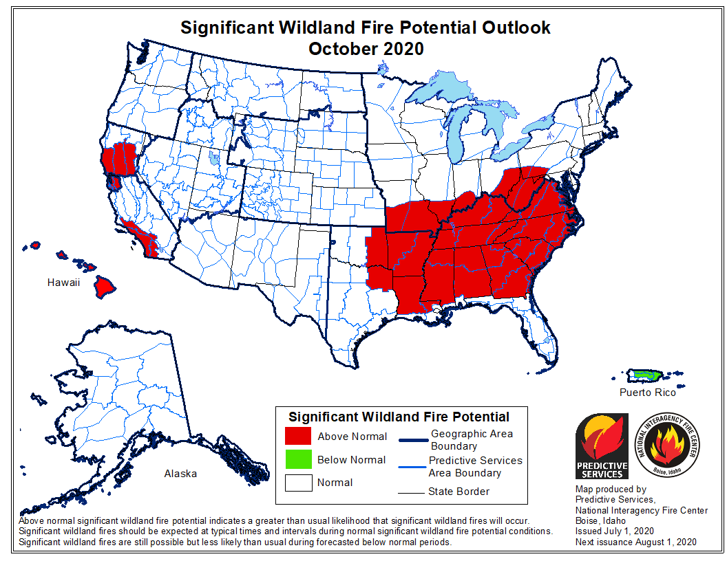
The National Significant Wildland Fire Potential Outlook issued August 1 by the Predictive Services section at the National Interagency Fire Center for August through November predicts that the northwestern states will have above normal potential through September. In October and November that distinction shifts to California and the southeast.

The data from NIFC shown here represents the cumulative forecasts of the ten Geographic Area Predictive Services Units and the National Predictive Services Unit.

Below:

  • An excerpt from the NIFC narrative report for the next several months;
  • More of NIFC’s monthly graphical outlooks;
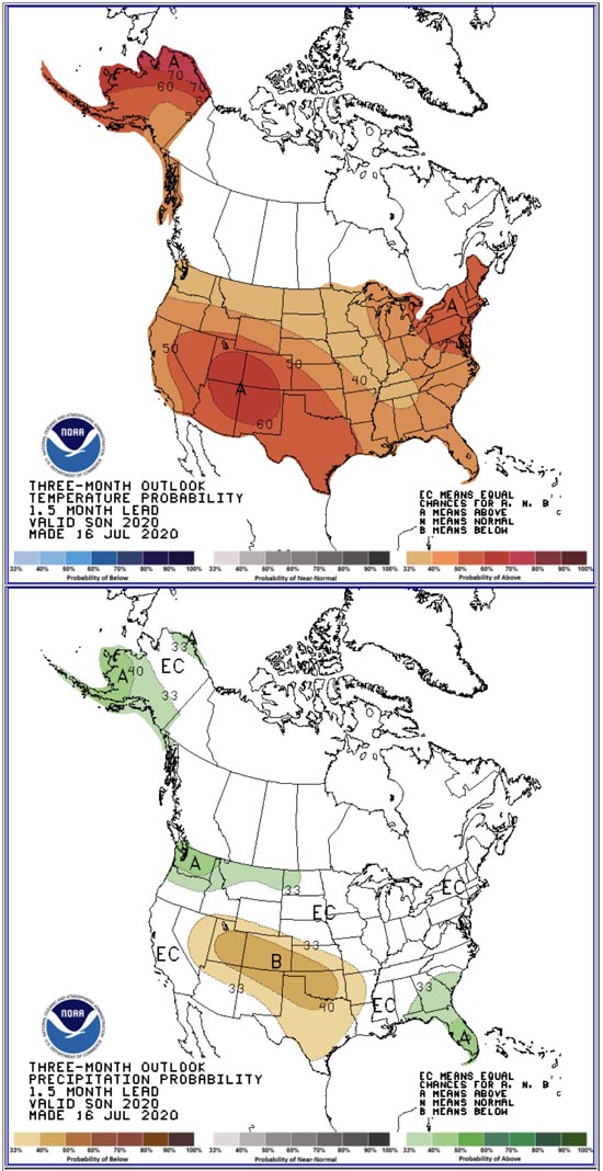
  • NOAA’s three-month temperature and precipitation forecasts;
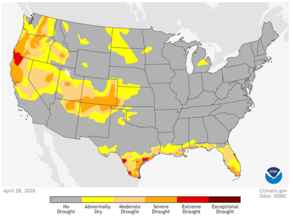
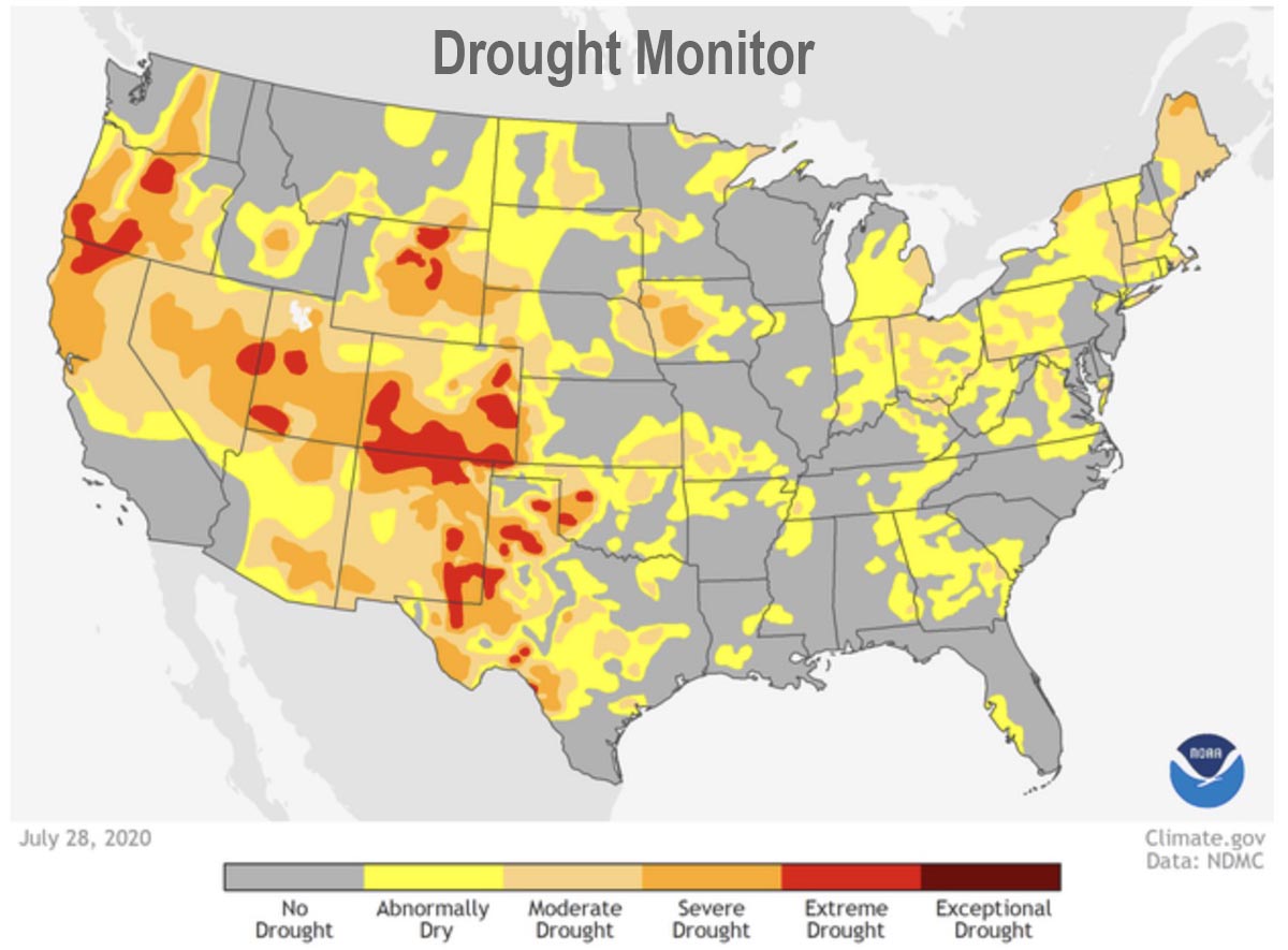
  • Drought Monitor;
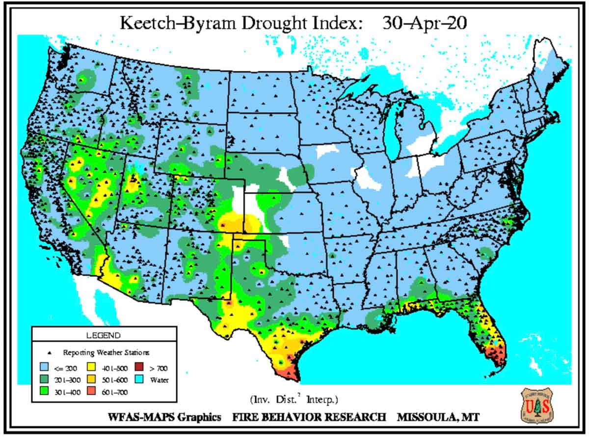
  • Keetch-Byram Drought Index.

“August represents the peak of fire season for the West and Above Normal significant fire potential is expected across much of the Great Basin, northern California, Pacific Northwest, and northern Rockies. The North American Monsoon is forecast to remain intermittent, which will provide chances of lightning without moisture surges extending into portions of the Great Basin, California, Pacific Northwest, and northern Rockies. Given the dry fuels, any lightning will likely result in increased fire activity and above normal significant large fire potential into September.

“As precipitation and cooler temperatures arrive in fall, areas of concern will shift southward to portions of California as offshore wind events become more likely. Without a robust monsoon and potentially delayed fall precipitation, fuels will remain very dry across much of California. With ENSO-neutral to potentially La Niña conditions, an increase of frequency of offshore wind events are possible. Additionally, drier than normal conditions are likely across much of the Southern Area given current long-term weather and climatological trends. However, an active hurricane season is a source of uncertainty.”
wildfire potential September

wildfire potential October
(We confirmed that the October graphic above was issued August 1, 2020 not  July 1, 2020 as indicated. It is a typo.)

wildfire potential November

Outlook temperature precipitation
Outlook for temperature and precipitation in September, October, and November. Prepared July 16, 2020. NOAA.
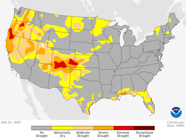
Drought Monitor July 28, 2020


Above normal wildfire activity predicted to expand from the Great Basin into the Northwest and Northern Rockies

wildfire potential July 2020

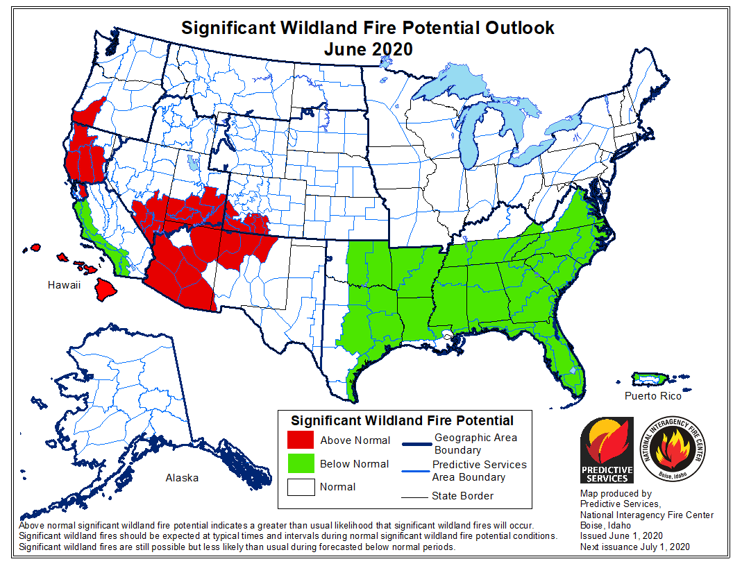
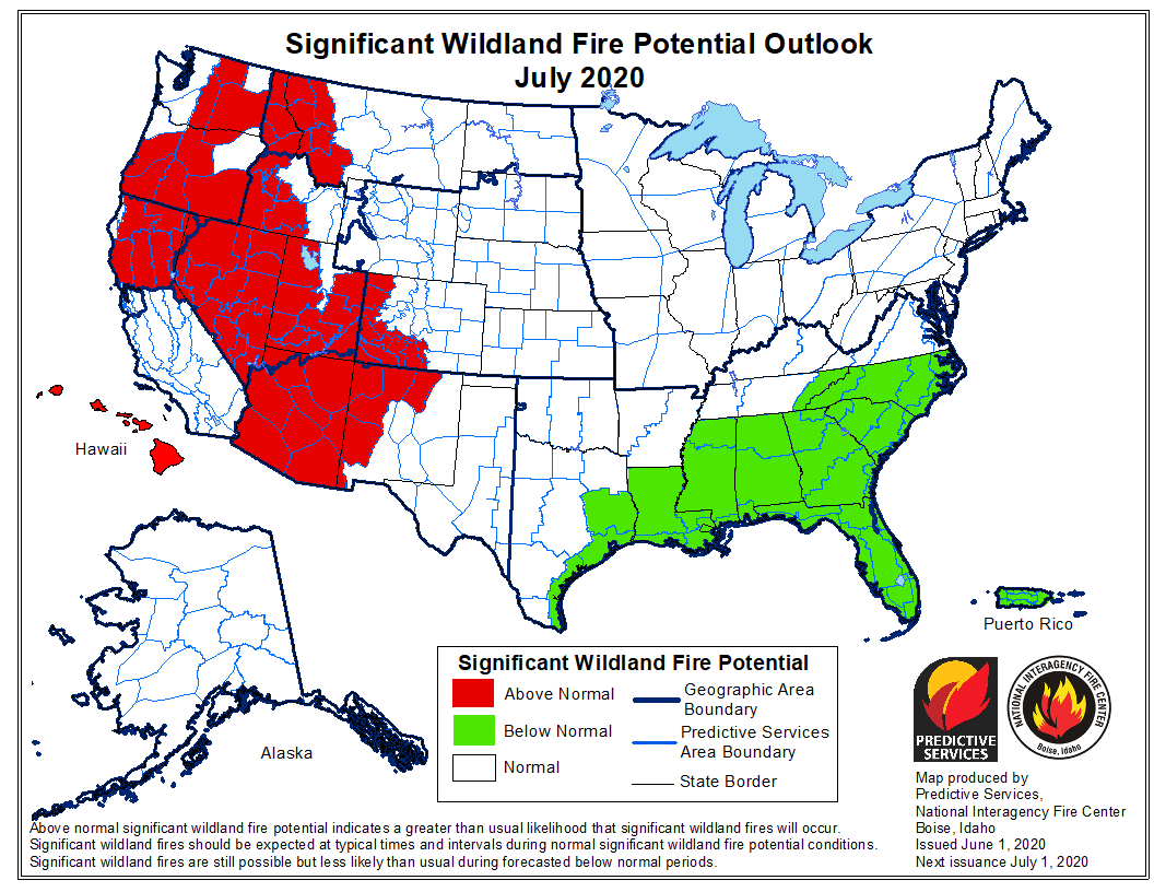
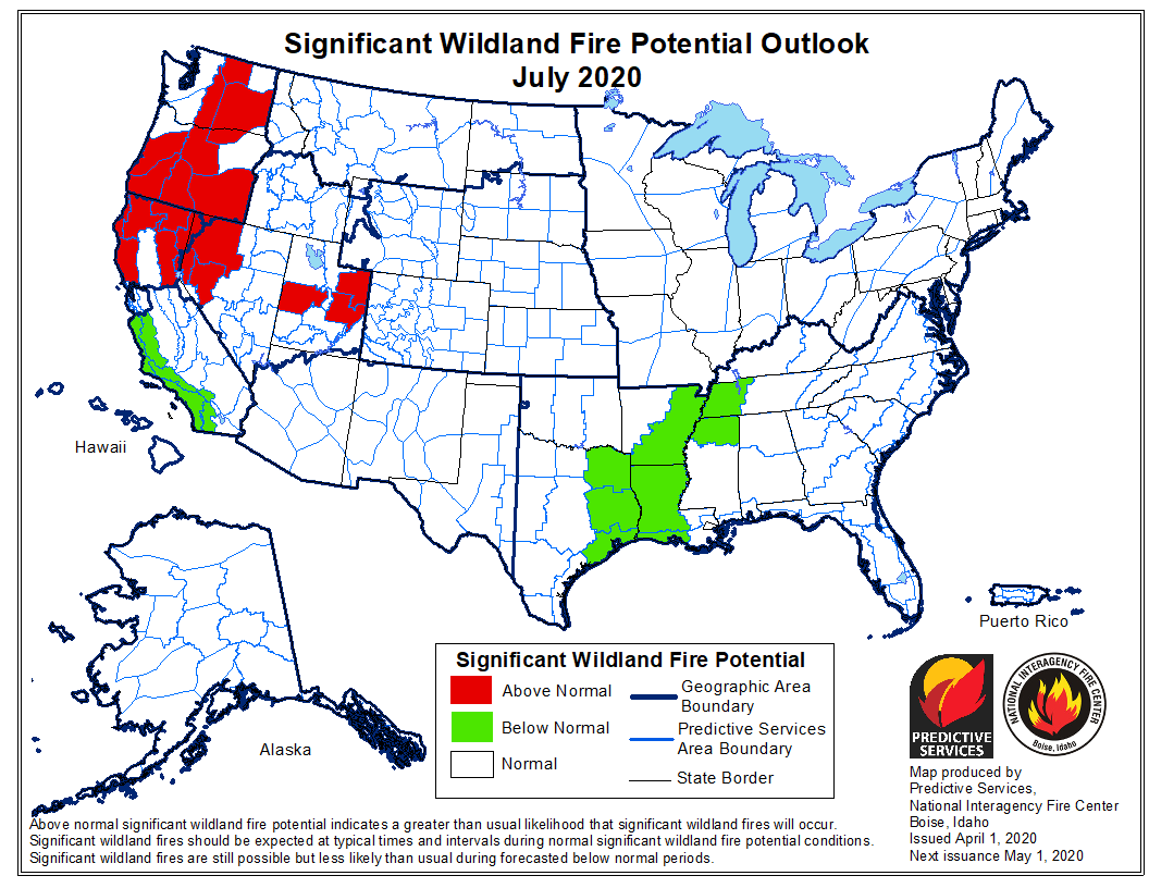
Today the Predictive Services section at the National Interagency Fire Center issued their National Significant Wildland Fire Potential Outlook for July through October.

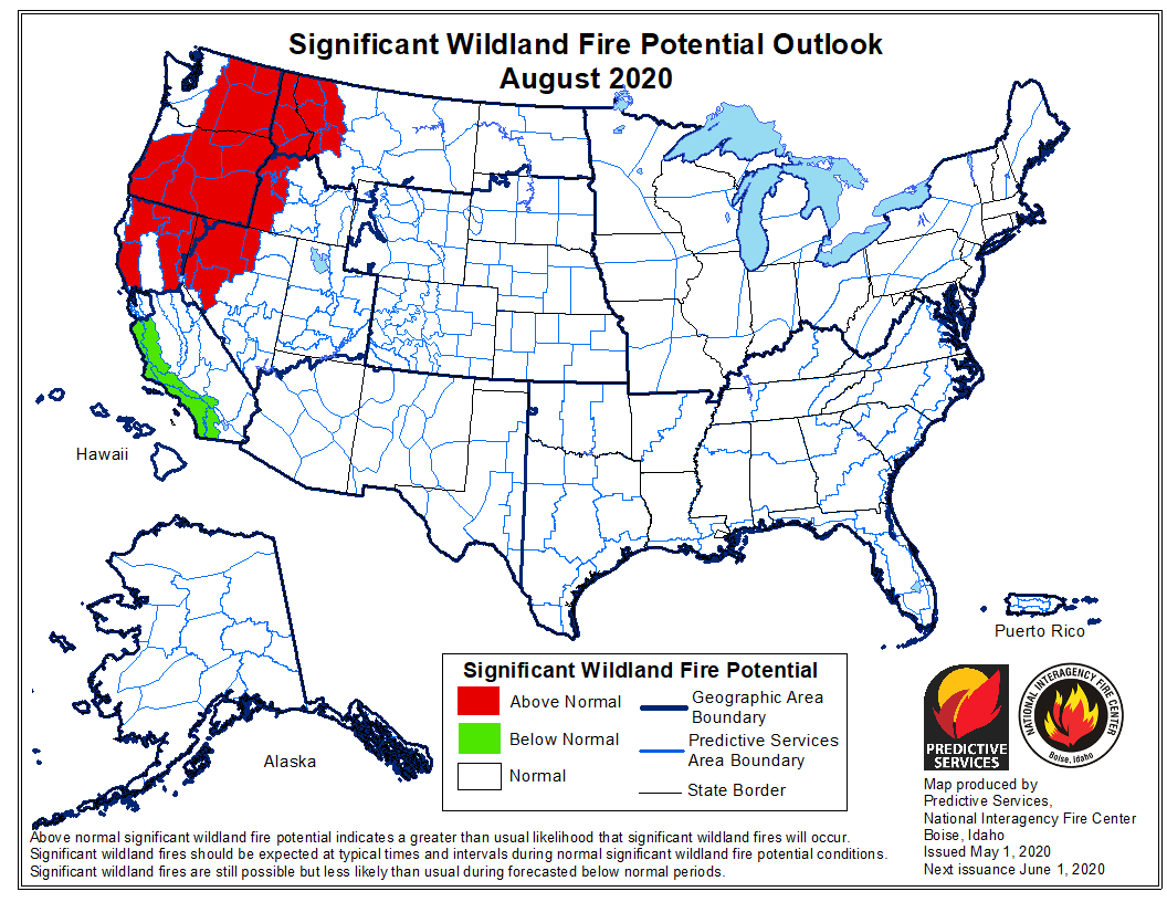
In July and August above normal wildfire potential is predicted to grow west and north across northern California, the Great Basin and the Central Rockies then expand into the Pacific Northwest and the Northern Rockies.

The data from NIFC shown here represents the cumulative forecasts of the ten Geographic Area Predictive Services Units and the National Predictive Services Unit.

Below:

  • An excerpt from the NIFC narrative report for the next several months;
  • More of NIFC’s monthly graphical outlooks;
  • NOAA’s three-month temperature and precipitation forecasts;
  • Drought Monitor;
  • Keetch-Byram Drought Index.

“Precipitation was below average in June across most of the country except across the Pacific Northwest where amounts were generally 150% of average or greater. Areas of concern emerged across California, the Great Basin, and Arizona where less than 5% of monthly precipitation was received. Temperatures were generally a few degrees above normal along the Pacific Coast and a few degrees below normal across the Interior West. In the East, temperatures were generally near normal in June.

“July is the entry point into the core of the Western Fire Season. As the season sequentially expands west and north across California, the Great Basin and the Central Rockies into the Northern Rockies and the Pacific Northwest, it will encounter areas of intensifying and expanding drought. This will lead to Above Normal significant large fire potential across large portions of the Great Basin and Northern California that will expand further north into the Pacific Northwest and Northern Rockies in August and September.

“The elevated potential in southwestern areas will begin to diminish with the arrival of the monsoon in early July. Activity will linger into mid-September in northern areas until the seasonal transition begins and begins to bring the season to a close. In Alaska, significant large fire activity will become less frequent in late July as returning moisture events gradually reduce the fire potential.”

wildfire potential August 2020 wildfire potential September 2020 wildfire potential October 2020

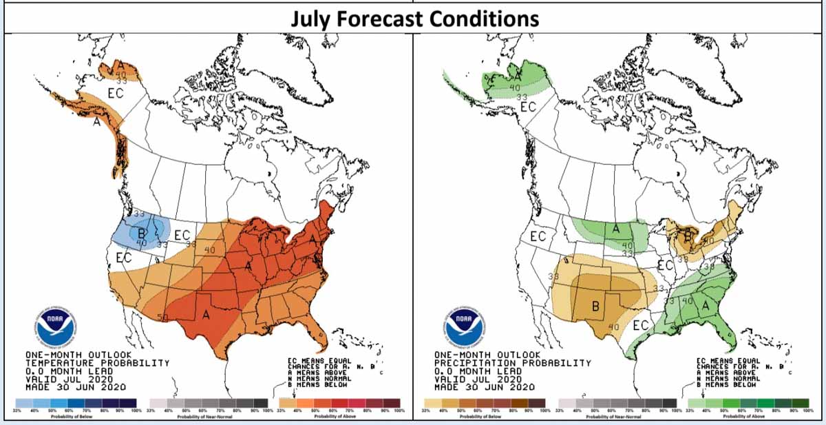
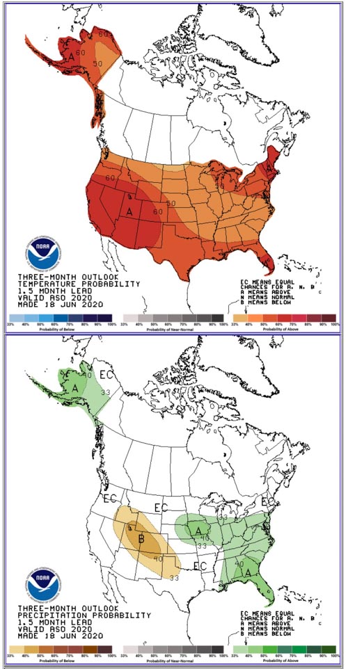
Temperature and precipitation forecast for July
Temperature and precipitation forecast for July.
Three Month weather Outlook
Temperature and precipitation forecast for August, September, and October.
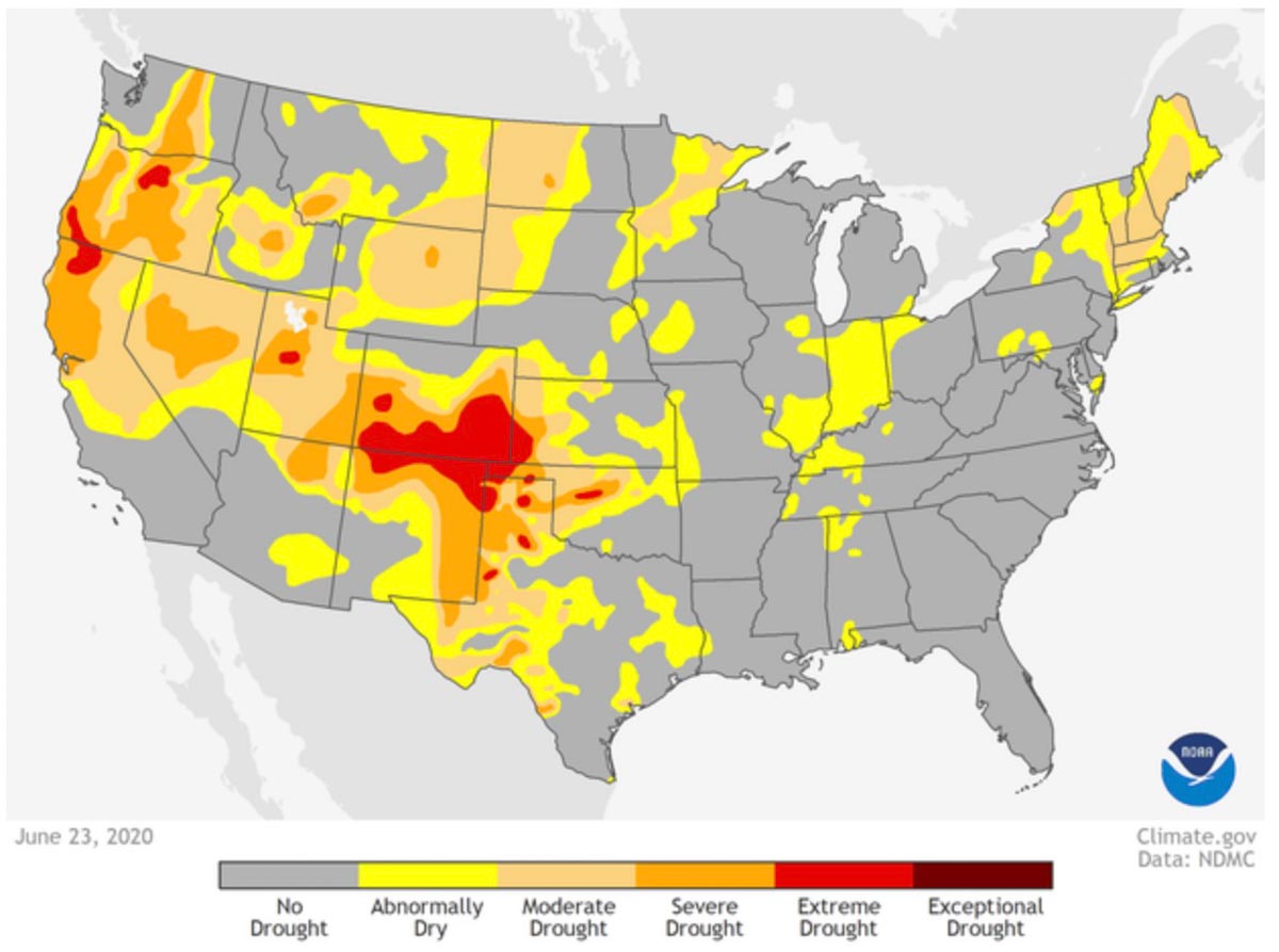
Drought Monitor issued June 25, 2020
Drought Monitor — June 23, 2020.
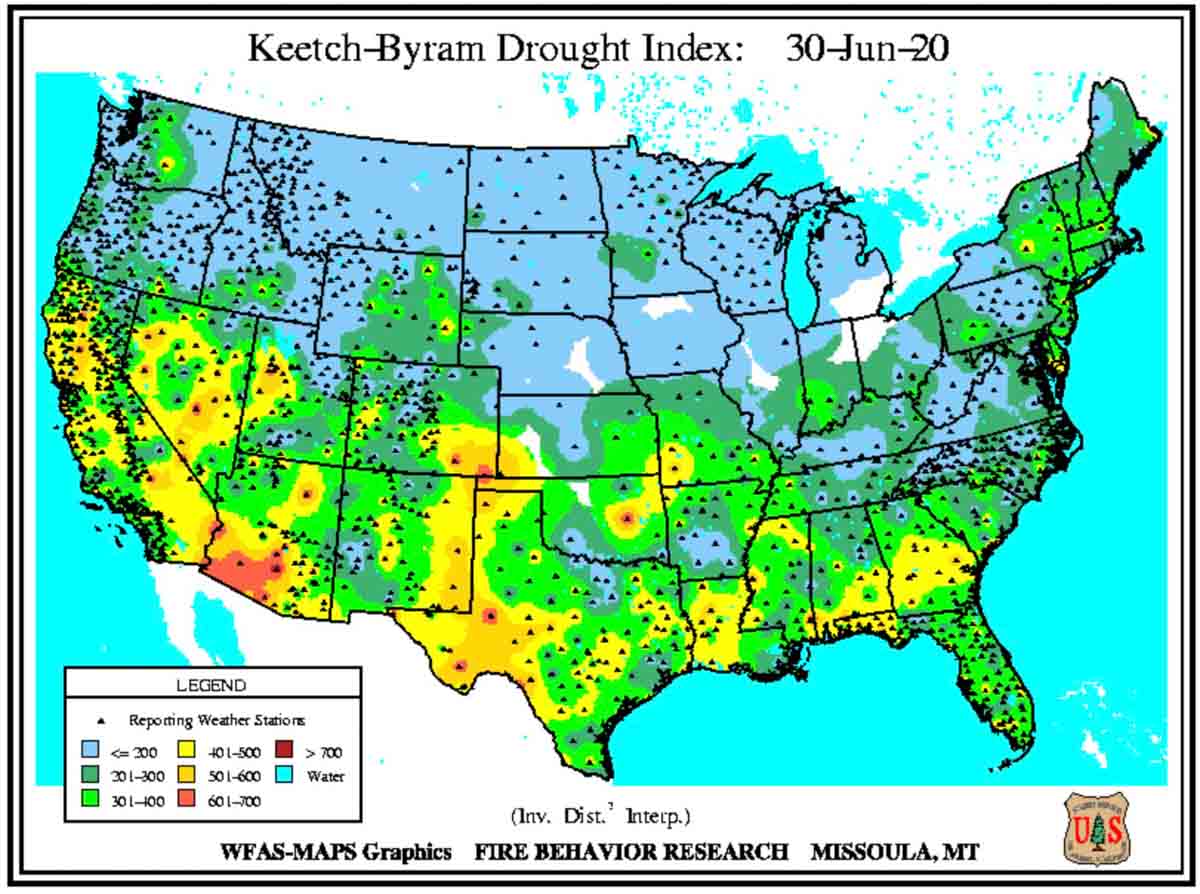
Keetch-Byram Drought Index, June 30, 2020
Keetch-Byram Drought Index, June 30, 2020.

Wildfire potential expected to be above normal in many western locations this summer

July could be a very busy month for wildland firefighters in the U.S.

potential wildfires fires weather forecast prediction

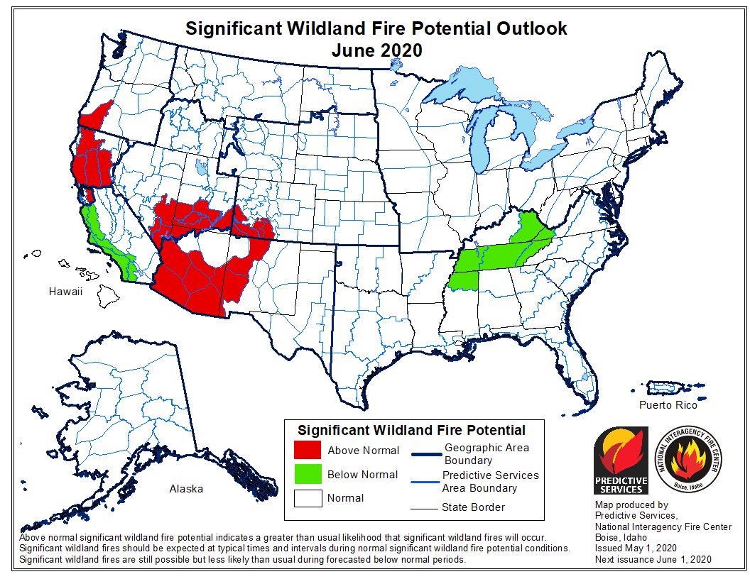
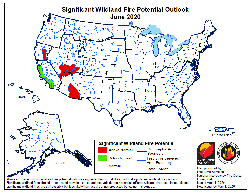
The National Significant Wildland Fire Potential Outlook issued today by the Predictive Services section at the National Interagency Fire Center for June through September indicates that many areas in the western United States will have above normal potential for wildfires. In July the increased fire danger is expected to affect significant portions of California, Washington, Oregon, Montana, Idaho, Nevada, Utah, Colorado, New Mexico, Hawaii, and Arizona.

The wildfire potential in the southern states is predicted to be below normal.

The data from NIFC shown here represents the cumulative forecasts of the ten Geographic Area Predictive Services Units and the National Predictive Services Unit.

Below:

  • An excerpt from the NIFC narrative report for the next several months;
  • More of NIFC’s monthly graphical outlooks;
  • NOAA’s three-month temperature and precipitation forecasts;
  • Drought Monitor;
  • Keetch-Byram Drought Index.

“June through early July is the peak of the fire season across the Southwest. Expect for the normal fire activity across the region to increase through the period with some areas experiencing Above Normal significant large fire potential, especially across Arizona. As the monsoon begins in mid-July, activity across the Southwest will diminish. Activity across Alaska will also diminish as the rainy season begins. California, central and northern portions of the Great Basin, the Pacific Northwest, and the Northern Rockies will begin to enter their peaks.

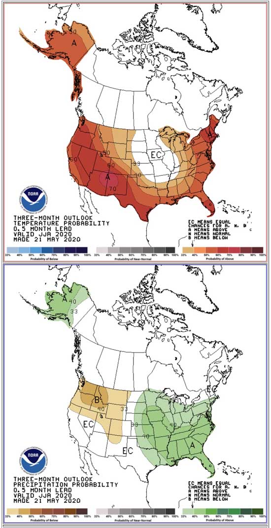
“Above Normal significant large fire potential is expected in the areas shown on the maps due primarily to increasing drought conditions, early loss of mountain snowpack, anticipated lightning activity, and overall hot and dry conditions that should persist through August. As is typically the case, the peak season fire activity across the northwestern portion of the country should diminish by mid-September as the seasonal transition begins and allows for wet fronts to bring precipitation to impacted areas.”


potential wildfires fires weather forecast prediction

potential wildfires fires weather forecast prediction

potential wildfires fires weather forecast prediction

drought monitor
Drought Monitor
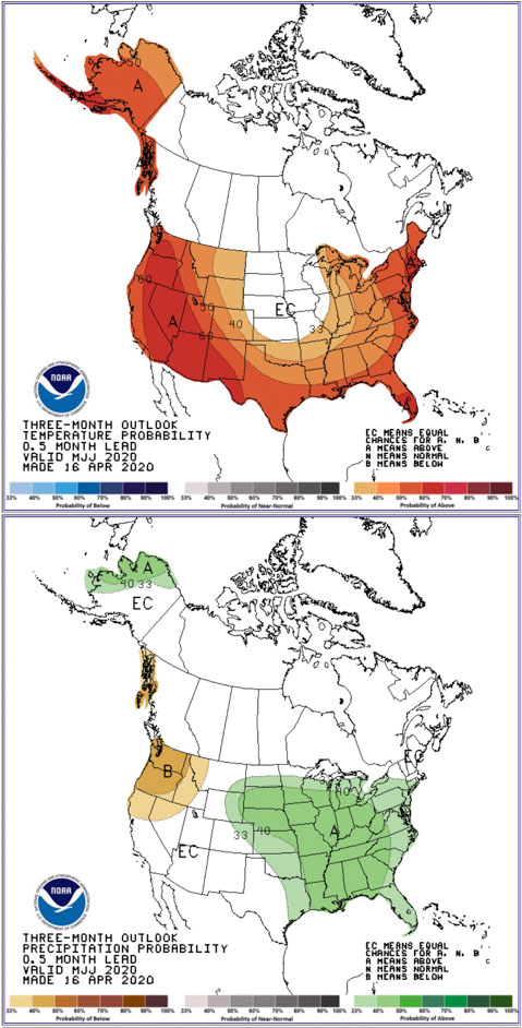
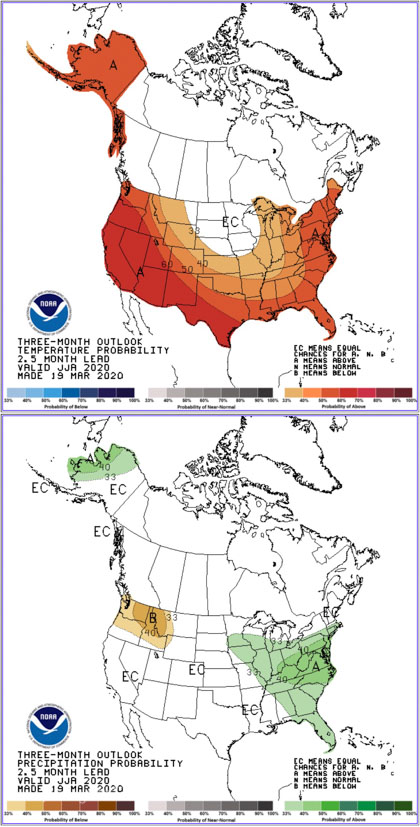
90 day temp precip
Forecast for temperature and precipitation, June through August, 2020. Made May 21, 2020.

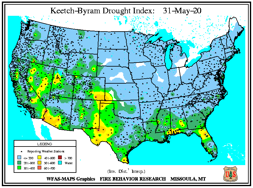
IKeech-Byram Drought Index

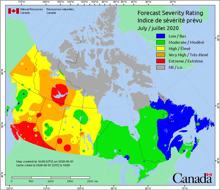
Increasing fire weather severity expected to bring extreme conditions to areas of Canada’s western provinces

Conditions in June and July are expected to be well above average.

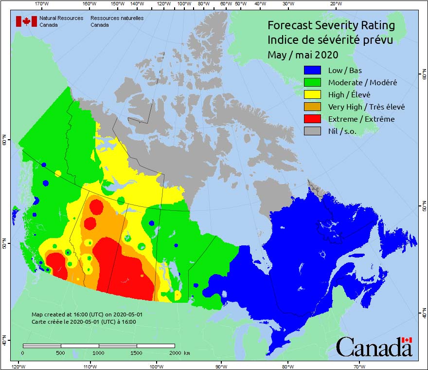
Canada Fire Weather Severity forecast May, 2020

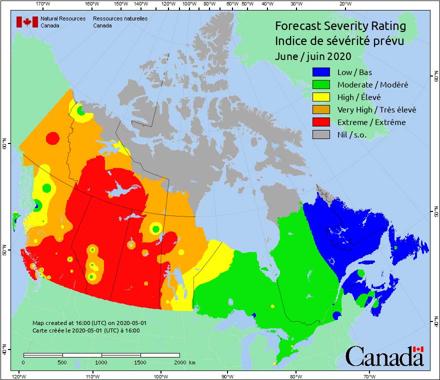
Forecasts are showing that fire weather severity in the western provinces of Canada will be increasing in May, and by June will be in the Extreme category in large areas of British Columbia, Alberta, Saskatchewan, and Northwest Territories.

Conditions in June and July are expected to be well above average, according to data from the Canadian Wildland Fire Information System provided by the Canadian Meteorological Centre, a branch of Environment Canada.

Canada Fire Weather Severity forecast June, 2020 Canada Fire Weather Severity forecast July, 2020

Above average wildfire potential predicted for southern Arizona and Florida this month

In June, above average wildfire potential is expected in California, Oregon, Nevada, Utah, Colorado, and New Mexico

May wildfire outlook

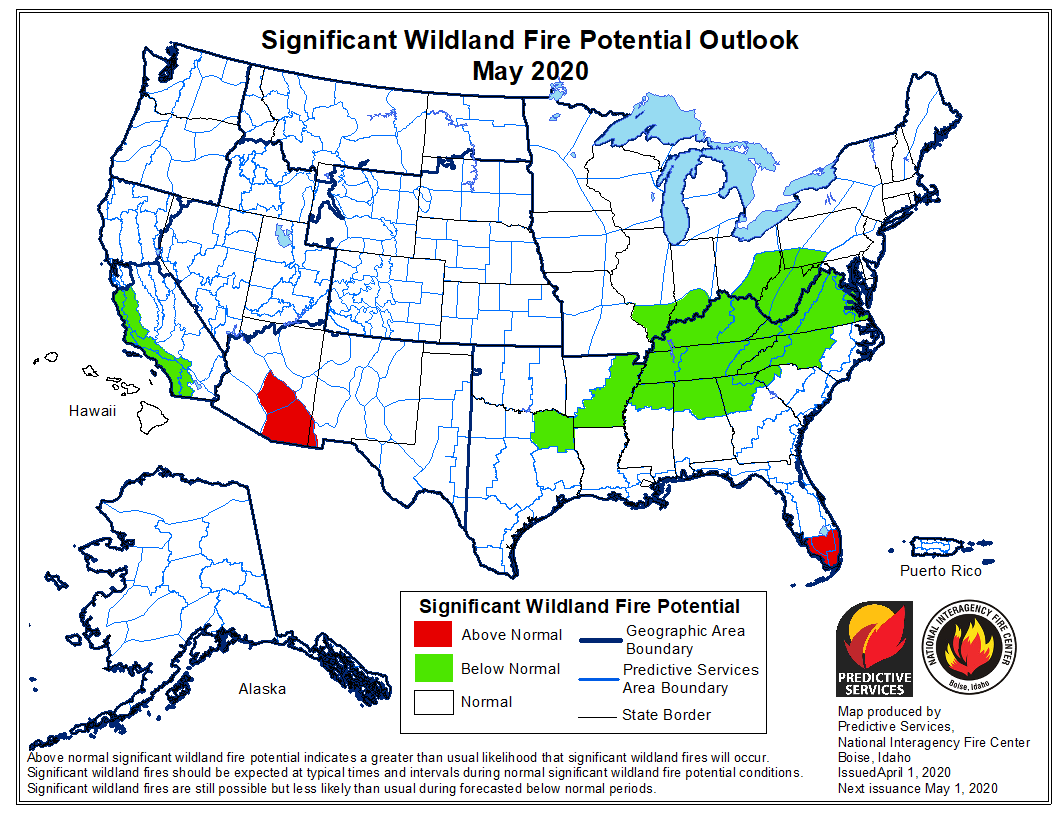
The National Significant Wildland Fire Potential Outlook issued today by the Predictive Services section at the National Interagency Fire Center continues to have generally good news for those concerned about wildfires. Similar to the prediction released a month ago for May, the only area in the United States likely to have above normal wildfire potential this month are the south portions of Arizona and Florida. That is expected to change in June with the addition of locations in California and parts of Nevada, Utah, Colorado, and New Mexico.

The data from NIFC shown here represents the cumulative forecasts of the ten Geographic Area Predictive Services Units and the National Predictive Services Unit.

Below:

  • An excerpt from the NIFC narrative report for the next several months;
  • More of NIFC’s monthly graphical outlooks;
  • NOAA’s three-month temperature and precipitation forecasts;
  • Drought Monitor;
  • Keetch-Byram Drought Index.

“Overall, the entry into the season is expected to be normal; however, there are areas of concern emerging for the summer months. While the Pacific Northwest received beneficial precipitation in late April, the overall pattern has been warm and dry which may be problematic for Oregon and Central through Eastern Washington. Northern California and the Great Basin area are also areas to monitor closely for Above Normal significant wildland fire potential as fuels continue to dry and cure. Additionally, fine fuel loading is expected to be above average for the third consecutive year in the lower elevations. Those fuels will dry and cure, becoming receptive to fire by mid-June.

“Other locations across the West and in Alaska can expect overall Normal conditions, though there could be pockets of Above Normal potential and activity along the Mexican Border in May and June before the anticipated arrival of a moderate monsoon in early July which should diminish fire activity in the Southwest while increasing activity further north across the Great Basin, Northern California, the Pacific Northwest, and the Northern Rockies by July.”
June wildfire outlook July wildfire outlook August wildfire outlook

90-day temp precip

Drought Monitor
Drought Monitor

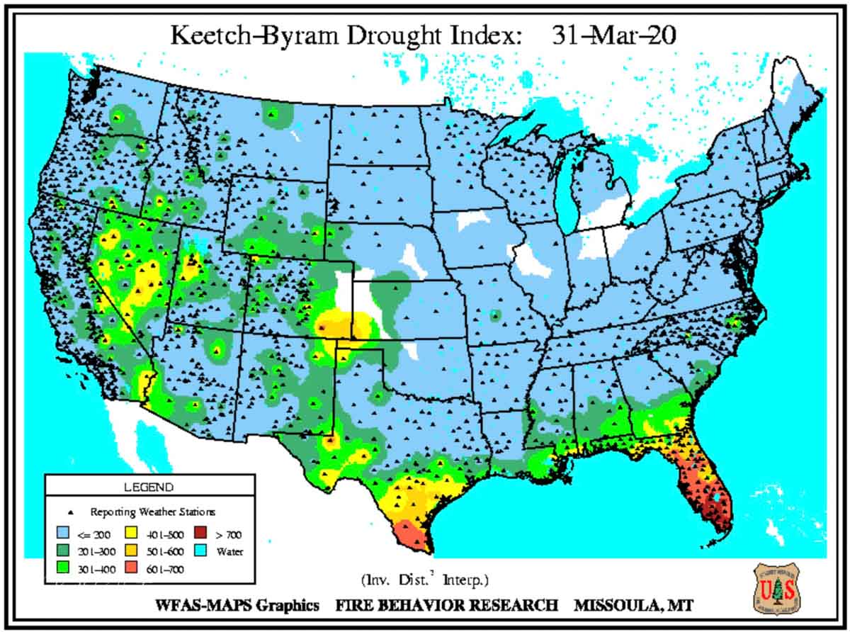
Keetch-Byram Drouth Index

NIFC releases prediction for wildfire potential, April through July

Wildfire potential weather July

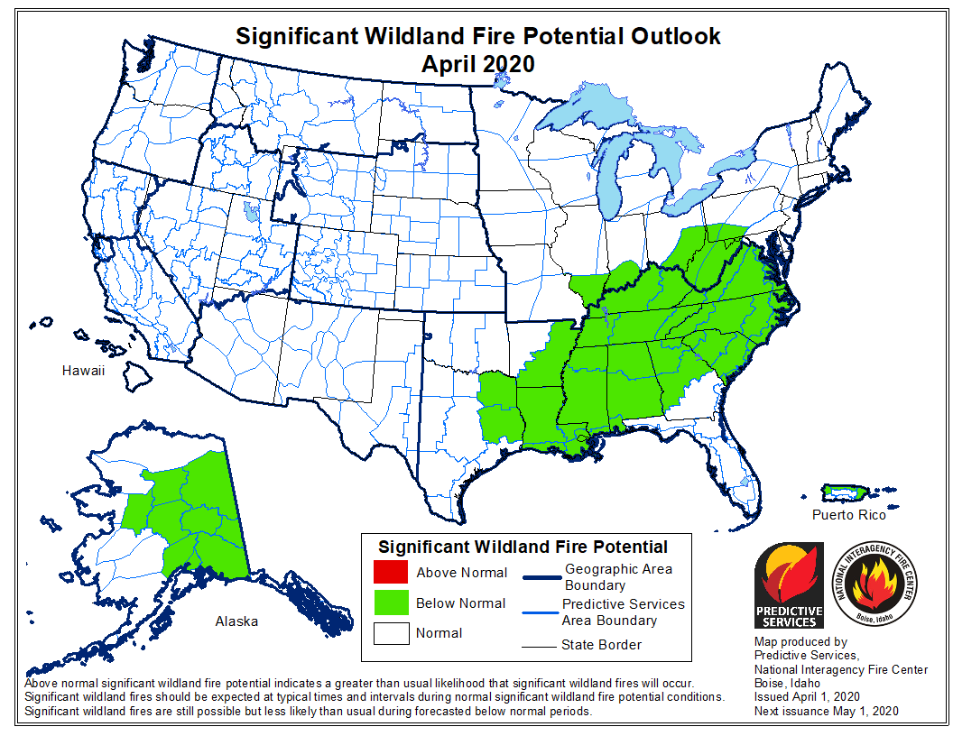
Today there is a bit of good news for anyone worried about how firefighters will control wildfires during the current coronavirus pandemic. The wildfire potential outlook issued by the National Interagency Fire Center (NIFC) on March 1 predicted that the coastal areas of Central and Southern California would have above average conditions for April, but that changed in a new outlook released today. As you can see in the map above there are no areas in the United States with forecasts for above normal wildfire activity in April.

That is expected to change in May with enhanced potential in southeast Arizona and south Florida. Then in June portions of northeast California and the southern areas of Nevada and Utah will be added to the list. In July firefighters could be busy in Washington, Oregon, and northern California.

The outlook comes from the Predictive Services section at NIFC and represents the cumulative forecasts of the ten Geographic Area Predictive Services Units and the National Predictive Services Unit.

The temperature outlook from the National Weather Service for April through June predicts higher than average temperatures in the west, southwest, southeast, and east. Precipitation for the period should be normal, except drier in the northwest and more rain than normal in the east one-third of the country.

Below:

  • An excerpt from the NIFC narrative report for the next several months;
  • More of NIFC’s monthly graphical outlooks;
  • NOAA’s three-month temperature and precipitation forecasts;
  • Drought Monitor;
  • Keetch-Byram Drought Index.

“Mountain snowpack remained near to above average on the Continental Divide, along the Canadian Border, and across the Alaskan Interior. It was below average to well below average across the High Sierra, Southern Cascades, Great Basin, Sawtooth Mountains, Kenai Peninsula, and the Chugach Mountains. Snowpack melting rates will need to be monitored closely in these areas. Drought development and slight intensification was observed across California, Oregon, portions of the Great Basin, South Texas and Florida.

“Wildfire activity in April should continue to be light and focused in four areas. South Florida has been extremely dry. Fuels are receptive. Pregreenup activity may occur during warm and breezy periods along the Rocky Mountain Front as fronts pass. New Mexico begins to enter its season late in the month. In Alaska, hold over activity from the previous season can reemerge as the snowpack melts off. The potential for each in April 2020 is not expected exceed what is observed typically, except possibly in Florida.

“May is a transitional period. Fuels in southwestern areas dry, and fuels across northwestern areas enter peak greenup. The Southwest, California and Alaska begin to more fully enter fire season while other regions remain out of season. A normal transition into the Western fire season is expected. Areas of concern will be the middle elevations across much of California. In June and July, the West and Alaska enter their peak seasons. Activity across Oregon and Central through Northern California may be above normal. While overall Normal significant large fire potential is expected across most of the Southwest, some portions of the Great Basin and western portions of the Northern Rockies may experience elevated potential and activity as well. The Southwest and Alaska should transition out of fire season in July.”
Wildfire potential weather May Wildfire potential weather June Wildfire potential weather April

Temperature and precipitation outlook
Temperature and precipitation outlook for June through August, 2020.
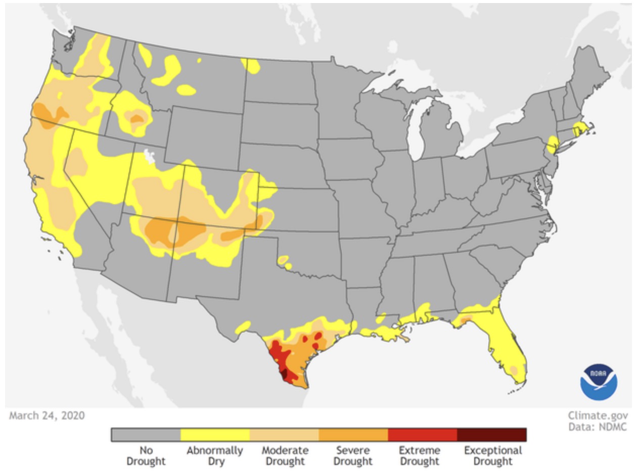
Drought Monitor
Drought Monitor

KBDI