Kruger Rock Fire prompts evacuations southeast of Estes Park, Colo.

Updated at 3:57 p.m. MST Nov. 17, 2021

Map, Kruger Rock Fire 3D 140 p.m. MST Nov. 16, 2021
The map shows the approximate location of the Kruger Rock Fire. It is based heat detected by satellites as late as 1:40 p.m. MST Nov. 16, 2021. Clouds degraded the ability of satellites to obtain good quality data.

In Colorado the local county sheriffs are given the responsibility for suppressing wildfires outside of cities. The Larimer County Sheriff’s office has not released much more information about the Kruger Rock Fire since the pilot of a single engine air tanker was killed in a crash while attempting to suppress the fire at about 6:35 p.m MST on Tuesday Nov. 16. It occurred about 1 hour and 49 minutes after sunset, and was the first time a fixed wing air tanker had dropped fire suppressant on a fire at night.

Wednesday afternoon the operator of the aircraft, CO Fire Aviation, released the name of the pilot, Marc Thor Olson.

The Sheriff’s office said Wednesday morning that there were changes in the evacuation areas, which can be seen on their map. The size of the fire was estimated to be 140 acres.

An investigation into the cause of the fire has revealed high winds blew a tree onto a power line causing it to arc and start the fire.


4:50 p.m MST Nov. 16, 2021

Map, Kruger Rock Fire
Map showing the approximate location of the Kruger Rock Fire. The two red dots represent heat detected by a satellite at 11:06 a.m. MST Nov. 16, 2021.

A new wildfire in Colorado has prompted evacuations east of Rocky Mountain National Park.

The Kruger Fire was reported at about 7 a.m. near Little Valley Road and Fish Creek Road near Kruger Rock 3 miles southeast of Estes Park and 2 miles east of Mary’s Lake. It is about 3 miles east of Rocky Mountain National Park.

At 3 p.m. fire officials estimated it had burned 115 acres. There are 150 personnel currently working the fire with more ordered.

At about 1:10 p.m. local time the Larimer County Sheriff’s Office issued a mandatory evacuation order for the area between Pole Hill Road and Panorama Peak on the east side of Highway 36. An hour earlier the office had issued a mandatory evacuation order for the area of Meadowdale, and south to the Boulder County line, to include Big Elk Meadows and Pinewood Springs west of Highway 36.

The evacuation map below is available online.

Kruger Fire evacuation map
Kruger Fire evacuation map, 1:32 p.m. MST Nov. 16, 2021.

Colorado Highway 36 is closed in the area.

Kruger Rock Fire
Kruger Rock Fire. Image by Michael Warren the morning of Nov. 16, 2021.

Strong winds in the fire area have kept firefighting aircraft grounded, except for an intelligence-collecting Multi-Mission plane flying thousands of feet over the fire. The wind direction at a weather station just west of the fire (at 7,841 feet) was quite variable Tuesday, blowing from the south, west and north at 5 to 13 mph gusting at 25 to 34 mph. At noon it was 73 degrees with 26 percent relative humidity. The forecast for the fire area calls for continued very strong winds until sundown and a chance for snow Tuesday night. It will be dry Wednesday and Thursday with high temperatures in the 30s and 40s under mostly sunny skies with the relative humidity around 20 percent. The wind chill will be below zero from Wednesday afternoon until Thursday afternoon.

400 firefighter hand crews are deployed on fires in the United States

Above: A firefighter ignites a burnout on the Powerline Fire southwest of Pocatello, Idaho. Uncredited Inciweb photo, posted August 6, 2017.

(Originally published at 12:48 p.m. MDT August 6, 2017)

Wildland firefighters are much busier this year than in a typical year. To date, fires have burned 46 percent more acres than the 10-year average — 5,820,802 acres vs. the 3,962,906 average. In some years fire activity in Alaska, where many very large fires are not suppressed, can inflate these numbers, but so far that state can only account for 626,786 acres, not a huge number for Alaska.

400 hand crews, usually comprised of 20 people each, are deployed nationwide, along with 949 fire engines, and 120 helicopters for a total of 16,673 personnel.

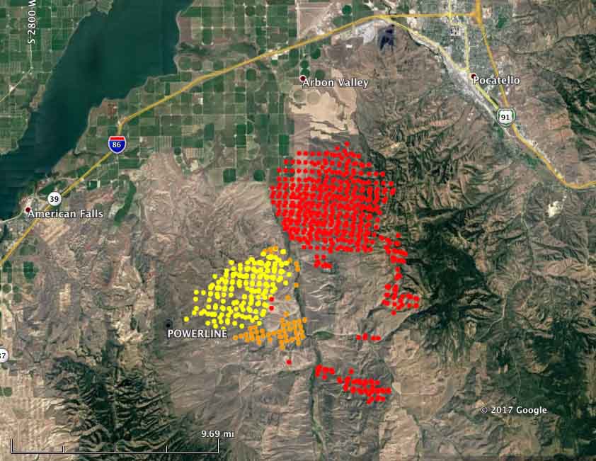
map powerline fire
Map showing heat detected on the Powerline Fire southwest of Pocatello, Idaho by a satellite August 5 and 6, 2016. The red dots are the most current, at 4:04 a.m. MDT August 6. Some areas with light vegetation, such as grass, may have burned and cooled before the satellite overflight and were not detected.

Here are brief descriptions of some of the larger or more prominent fires:

  • Powerline (see the map and photo above): Since it was reported Friday night this fire has spread very rapidly. Saturday it was very active on the northeast and southeast sides. Using satellite data the Incident Management Team estimated early Sunday morning that it had burned over 40,000 acres, but that is a very rough guess. More accurate mapping by fixed wing aircraft will provide better numbers. The satellite information indicated that by 4:04 a.m. Sunday it had spread to within 6 miles of Pocatello, Idaho. It is moving into steeper terrain with heavier fuels, offering more resistance to control and is the #2 priority in the Great Basin Geographic Area according to the national situation report.
  • Mammoth Cave, southwest of Carey, Idaho. Since it started August 4 it has burned three structures and 30,000 acres. It is the number 1 priority in the Great Basin Geographic Area.
  • The Shoestring Fire between Shoshone and Gooding, Idaho has blackened about 12,000 acres since it started August 5. It is the #3 priority in the Great Basin Geographic Area.
  • The Rice Ridge Fire northeast of Seeley Lake, MT is the #1 priority in the Northern Rockies Geographic Area and is threatening over 1,000 structures. It added almost 700 acres on Saturday to bring the total to 7,740.
  • The Sunrise Fire, 12,900 acres, the #2 priority in the Northern Rockies Geographic Area, grew by 600 acres Saturday. It has been burning since July 16, growing every day, adding several hundred acres daily on the east or northeast sides. It is now mapped at 12,900 acres.
  • The Hanover Fire, in a very remote area 15 miles northwest of Riggins, Idaho, was extremely active on Saturday. The Incident Management Team reports that it has burned 4,479 acres.
  • Parker 2, 10 miles east of Alturas, California. It was very active Saturday, adding 5,300 acres, growing to 7,100 acres.
  • Minerva 5, just south of Quincy, California. It has burned 4,088 acres and the voluntary evacuation of the town has been lifted. Firefighters completed a firing operation Saturday night.
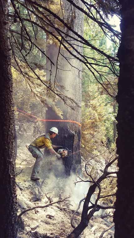
 sawyer Minerva 5 Fire
A sawyer on the Minerva 5 Fire, August 2, 2017. Inciweb photo, uncredited.

The desert changes one year after the Powerline Fire in Big Bend NP

Above: Charred Pitaya cactus in Big Bend National Park during the Powerline Fire, February 2, 2017. NPS photo.

A year ago the Powerline Fire burned 1,792-acres near the headquarters of Big Bend National Park in south Texas. Since then a tireless camera has been taking photos of a particular area. When they are put together in a time-lapse fashion the resurgence of the vegetation is enough to convince anyone to stop using the word “destroyed” when describing the effects of a wildfire.

I almost decided not to post the video below because unfortunately the resolution of the photos is very, very poor, but check it out for yourself.

Powerline Fire burns near headquarters of Big Bend National Park

(UPDATED at 7:35 p.m. CST February 5, 2015)

Big Bend National Park reports that the 1,792-acre Powerline Fire is 98 percent contained. They will begin demobilizing firefighting resources Saturday.

****

(UPDATED at 5:42 p.m. CST February 4, 2016)

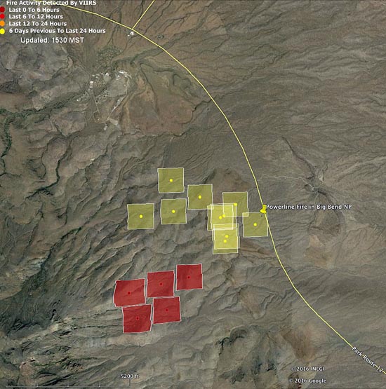
Below is an updated satellite map of the Powerline Fire in Big Bend National Park in south Texas.

Map Powerline Fire 148 pm CST 2-4-2016
Map showing heat detected by a satellite (the red squares) on the Powerline Fire at 1:48 p.m. CST February 4, 2016. The fire appears to be spreading toward the southwest.  Some areas of the fire, especially east of the road, burned and cooled between satellite over flights, and were not detected. The park headquarters and employee housing area can be seen north of the fire.

****

(UPDATED at 10:55 CST, February 4, 2016)

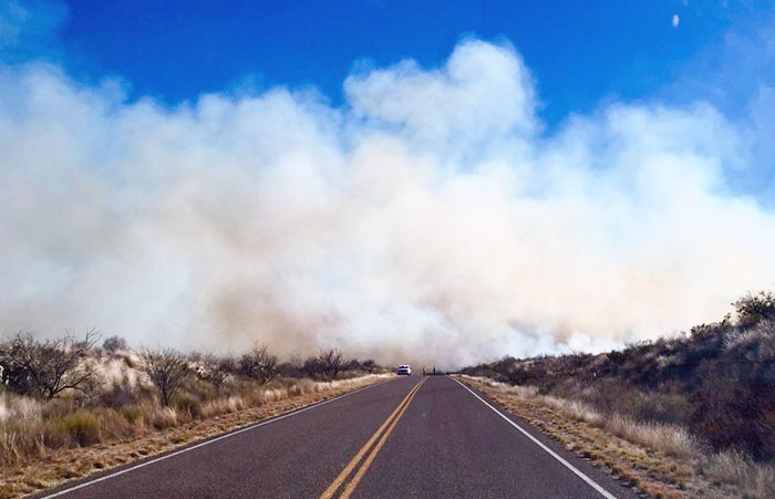
Powerline Fire
Poweline Fire in Big Bend National Park, the afternoon of February 3, 2016. NPS photo.

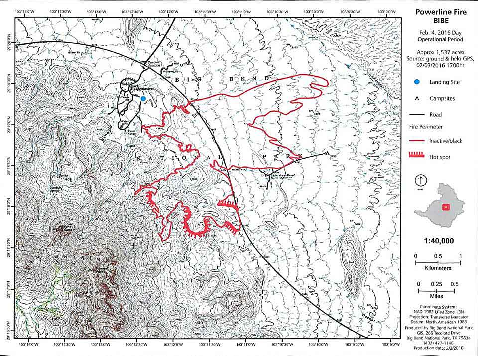
Better mapping has revealed that the Powerline Fire in Big Bend National Park in south Texas had burned 1,537 acres as of 5 p.m. CST on Wednesday, which is a revision of the earlier estimate of 1,995 acres.

Late on Wednesday the park reported that the fire had approached the southern side of the road between Panther Junction and Rio Grande Village, but it had not jumped the road since Monday February 1st and there was no active fire on the north side of the road.

Powerline Fire map
Map of the Powerline Fire for the February 4 operational period. Park Headquarters and the employee housing area are just northwest of the fire. NPS.

Continue reading “Powerline Fire burns near headquarters of Big Bend National Park”