Wildfire briefing, February 27, 2014

Dynamic Aviation Citation lead plane
Dynamic Aviation’s Citation CJ lead plane. Photo courtesy of Dynamic Aviation.

BLM awards contract for first jet-powered lead plane

The Bureau of Land Management has awarded a contract for the first jet-powered lead plane in the United States. Lead planes fly ahead of the much larger air tankers that drop retardant on fires. They identify the targets and evaluate the fire and wind conditions. Dynamic Aviation, with headquarters in Bridgewater, Virginia, will be supplying a Cessna Citation CJ to serve as a lead plane and Air Supervision Module (ASM) this fire season. With the jet-powered air tankers now in use, including DC-10s, BAe-146s, and MD-87s, there is a need for a lead plane that can keep up with the “next-generation” air tankers.

(More information is at Fire Aviation.)

Evacuations ordered in southern California fire areas before storm

Mandatory evacuations have been ordered for about 1,000 homes that could be affected by debris flows out of recent wildfires in the Glendora and Azusa areas. The Colby Fire burned 1,952 acres of the hillsides above the communities on January 16, 2014.

Weather forecasters have predicted several inches of rain for some areas in southern California between Thursday and Saturday.
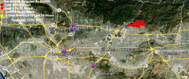
Map showing the approximate location of the Colby Fire at 10:37 a.m. PST, January 16, 2014
Map showing (in red) the approximate location of the Colby Fire at 10:37 a.m. PST, January 16, 2014. (click to enlarge)

“Ice makes a good firebreak”

From The Nature Conservancy, describing a prescribed fire in Oklahoma:

Crews use drip torches to start the 475-acre controlled burn at the Four Canyon Preserve

“We took advantage of a break in the weather on February 1 and completed a 475-acre prescribed burn at the Four Canyon Preserve. This work was funded by a ConocoPhillips and National Fish and Wildlife Foundation grant, and it wouldn’t have been possible without their help,” said Chris Hise, Four Canyon Preserve Manager. “It’s very early in the season to be burning here, but we’re trying to stay ahead of a worsening drought situation. I had the odd experience of carrying a drip torch along the frozen banks of the Canadian River. Ice makes a good firebreak.”

More info, and photos, are at The Nature Conservancy’s website.

NASA photograph of a fire in Australia

A large fire burning in and around Grampians National Park in Victoria, Australia, was nearly contained when the Operational Land Imager on the Landsat 8 satellite acquired this image on January 19, 2014. The burned land is gray-brown in this natural-color image. Active fires were burning on the east side of the burn area, sending up plumes of smoke.
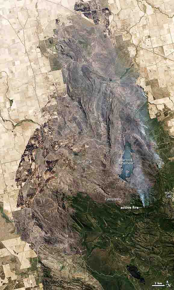
Bushfire in Grampians NP, Victoria, Australia
Bushfire in Grampians NP, Victoria, Australia. NASA photo.

USFWS prescribed fire in Oregon

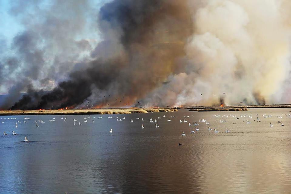
Rx fire at Malheur Nat'l wildlife Refuge. USFS photo by Shane Theall.
Rx fire at Malheur Nat’l wildlife Refuge. USFS photo by Shane Theall.

According to the U.S. Fish and Wildlife Service. their….

Malheur Fire Program and the Burns Interagency Fire Zone conducted a 2,250-acre prescribed fire on the Deer Park Unit of Malheur National Wildlife Refuge this week. Located in southeastern Oregon’s high desert, at the northern end of the Great Basin, the 187,000-acre National Wildlife Refuge is famous for its spectacular concentrations of wildlife. With its abundant water resources in an otherwise arid landscape, the Refuge hosts more than 320 bird species and 58 mammal species.

Rx fire at Malheur Nat'l Wildlife Refuge. USFWS photo by Carla Burnside.
Rx fire at Malheur Nat’l Wildlife Refuge. USFWS photo by Carla Burnside.

Report released on escaped prescribed fire at Devils Tower

Above: Map, showing the approximate location of the planned prescribed fire at Devils Tower (300 acres in white) and the 56 acres (in red) that escaped beyond the planned perimeter. Image from Google Earth. Perimeters by Wildfire Today.

Yesterday after Wildfire Today made inquiries about reports that may have been completed regarding the escaped prescribed fire on May 8, 2013 at Devils Tower National Monument in Wyoming, the National Park Service released the official review of the incident.

The NPS ignited the 300-acre unit on May 7, 2013. Several spot fires occurred outside the planned perimeter that were contained the first day. But during mopup at 12:50 p.m. on May 8 fire became established again at one of the spot fire locations on the southwest side of the project. At that time the cooperating U.S. Forest Service resources present the day before had been released. Some of the remaining firefighters were concentrating on the previous day’s spot fires at another location, but most of the firefighters were attending an After Action Review of a non-injury tipover of a Utility Task Vehicle (UTV) that occurred the day before. The 56 acres burning outside the burn unit were mostly stopped at the Monument boundary, but a few acres crossed over onto private land leased by Wyoming state Senator Ogden Driskill, but no structures were damaged.

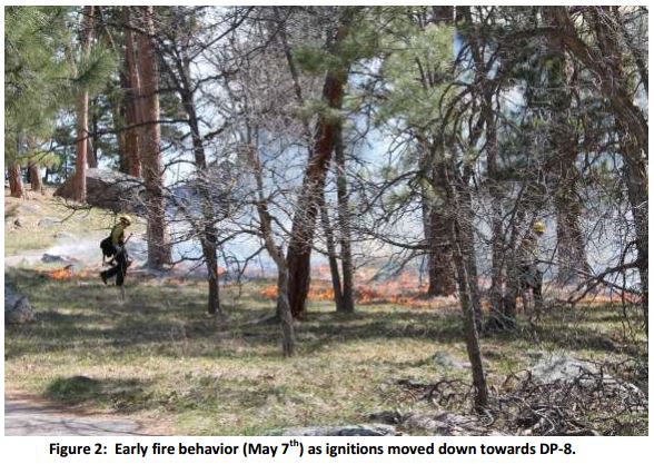
Devils Tower Rx fire, May 8, 2013
Devils Tower Rx fire, May 7, 2013. NPS photo.

In the interest of full disclosure, Devils Tower was one of the seven National Parks for which I was the Area Fire Management Officer, from 1998 until 2003.

The review pointed out several times that one of the primary issues related to the escape was that in computing the fine dead fuel moisture, it was assumed that the fire would be shaded by the smoke column. However, some of the area was not shaded, and for two hours each day on May 7 and 8, at those locations the fine dead fuel moisture dropped below the 4 to 10 percent allowed in the prescription, down to 3 percent.

Other than how the weather affected the fuel moisture, the review barely mentioned the weather conditions and the forecast. Two spot weather forecasts were issued before the escape — one at 7:57 a.m. MDT on May 7 and another at 9:29 a.m. on May 8, the day of the escape. For May 8, both forecasts predicted fairly strong northeast winds, of 7 to 15 mph and 8 to 14 mph.

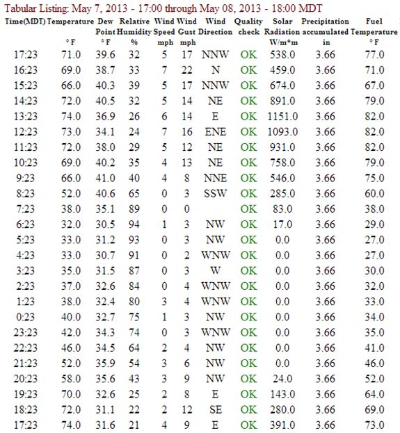
The Remote Automatic Weather Station at Devils Tower is very close to the location of the prescribed fire, in a low-lying area partially sheltered by trees from winds from all directions (see map above). Northwest, north, and northeast winds are additionally partially blocked by higher ground and the Devils Tower itself. Below are the weather observations from the weather station between 17:23 on May 7 through 17:23 on May 8. They show mild sustained wind speeds, with gusts around mid-day to late afternoon on May 8 of 13 to 22 mph. If the weather station was in a more exposed location the recorded speeds would have been higher.

Devils Tower weather, May 7 and 8, 2013

The NPS committed four people to the facilitated learning analysis of the non-injury slow tip over of the UTV, and three to the review of the escaped prescribed fire.

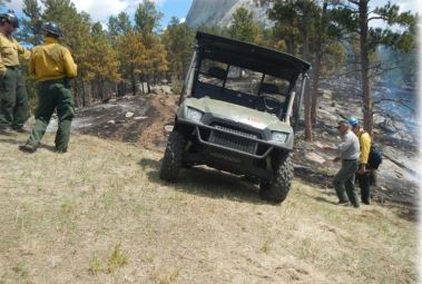
UTV at Devils Tower
Photo from the FLA for the UTV tip over, that presumably shows a UTV in the approximate location of the accident. NPS photo.

We initially covered the prescribed in 2013 fire HERE and HERE.

Weather cited as primary issue in escaped prescribed fire near Hettinger, ND

Pautre Fire origin

A report issued by the U.S. Forest Service for a prescribed fire that escaped on the Dakota Prairie National Grasslands in northern South Dakota last year cited weather as being one of the primary factors in losing control of the fire.

The Pasture 3B prescribed fire was planned at 210 acres, but strong winds on April 3, 2013 caused by the predicted passage of a cold front pushed the fire across a mowed fire line into tall grass and ultimately burned 10,679 acres, (3,519 acres federal and 7,160 acres private). The wildfire, named Pautre Fire, was stopped at 11 p.m. that night.

On April 3, 2013 we wrote about the wildfire:

An article in The Rapid City Journal has more information about the impacts of the fire on the ranchers. Privately owned grazing, hay stacks, and miles of fencing were damaged or destroyed during the ranchers’ calving season. Here is an excerpt:

“Laurie Casper, 36, said the fire destroyed 95 percent of her family’s farmland, which is more than 1,000 acres.

‘We lost all of our calving pasture, we lost our summer grazing, we lost our fall grazing, we lost 100 percent of our alfalfa— which we cut for hay bales in order to feed the cattle this oncoming winter— all that’s completely gone,’ she said. ‘And there’s just just miles and miles of fences that are completely gone.’ “

The prescription in the project’s burn plan for the maximum wind speed at eye level was 15 mph and the maximum wind speed at the 20-foot level was 20 mph. One of the spot weather forecasts for the morning of the prescribed fire predicted the passage of the cold front, with winds shifting from the south at 5 to 11 mph in the morning, to northwest at 25 mph with gusts to 30 mph in the afternoon. The actual weather that day was very similar to the forecast.

About a month later, another prescribed fire not too far away, at Devils Tower National Memorial in western Wyoming, also escaped, due partially to strong winds. That report still has not been posted on the Wildland Fire Lessons Learned Center website. We were told today that was due to a glitch, and it will appear there very soon, possibly as early as today, February 4. (UPDATE, February 5, 2014: the National Park Service arranged to have the Devils Tower report posted late in the day on February 4. We wrote about it here.)

Pautre Fire. US Forest Service photo.

The report said firefighters concluded they would not do much different next time (page 12):

Firefighters did an excellent job of planning, organizing and executing this prescribed fire and adhering to the prescribed fire plan. Following the control of the escaped fire some firefighters had difficulty thinking of anything they would do differently next time. While it is true that we work in a dangerous environment with unexpected changes in weather, we strive to be a learning culture and continuously improve our ability to make decisions that evaluate risk and get work done on the ground.

Some of the issues listed by the Facilitated Learning Analysis team included:

  • Improved weather forecasts are needed.
  • Consider additional research on methods to predict effects of drought on fire behavior in grass fuel models.
  • The nearest remote automated weather station (RAWS) is more than 90 miles away.
  • The project was conducted at the critical edge of the prescription.
  • Consider gaming out worst case scenario “what ifs” during the planning process, and discuss with participants during the on-site briefing.
  • There were problems with radio communications [note from Bill: I don’t remember EVER seeing a report like this that did not cite radio communications as being an issue].

The commendations section included this:

The personnel involved in all levels of the Pasture 3B prescribed fire were motivated, worked well as a team, were adequately trained, and appropriately briefed. They had a keen awareness that this was the first burn of the year, and took numerous precautions to ensure successful completion of the prescribed fire.

We did not see any mention in the report of damaged fences, hay, or pastures.

Some ranchers in western North Dakota donated hay to the South Dakota ranchers who lost theirs in the escaped prescribed fire.

Prescribed fire photos

BLM, Devil Canyon Rx 1-28-2014
BLM Utah, Devil Canyon pile burning, January 28, 2014

While it may be too dry in some areas to conduct prescribed fires, that is not the case everywhere as you can see in these photos.

BLM Devil Canyon Rx  1-28-2014
BLM Utah, Devil Canyon pile burning, January 28, 2014
Kiabab NF Gov Prairie Rx 1-2014
Kiabab National Forest in Arizona, Government Prairie prescribed fire, January, 2014
Kiabab NF Gov Prairie Rx, 1-2014
Kiabab National Forest in Arizona, Government Prairie prescribed fire, January, 2014
Shasta T Northwood Deuce Rx 11-1-2013
Shasta Trinity National Forest in Callifornia, Northwood Deuce prescribed fire, 11-1-2013

And below is a bonus photo, not from a prescribed fire, but after a wildfire.


Wildfire briefing, January 6, 2014

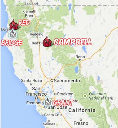
January wildfires in northern California

Map northern California fires

Even though a major winter storm has caused 4,121 flights to be cancelled and another 11,284 to be delayed today across the United States, northern California has experienced four medium to large fires already this year.

  • The Campbell Fire, which started January 2 on the Lassen National Forest 24 miles southeast of Red Bluff, according to the U.S. Forest Service has burned 600 acres and is 40 percent contained. No structures are threatened and no evacuations are planned for this fire that is burning in the proverbial “steep, rugged terrain”. Minton’s NORCAL Incident Management Team 1 is assigned.
  • The Red Fire, south of Berry Summit in Humboldt County, has burned 350 acres and is 40 percent contained. It started January 4.
  • The Bridge Fire, near Bridgeville in Humboldt County, started January 3 and burned 18 acres. It is 100 percent contained.
  • The Honcut Fire, started January 1 in Butte County near Honcut and burned 60 acres before it was contained.
  • The Grant Fire, started December 31 and burned 40 acres in Santa Clara County near Grant Ranch County Park before it was contained.

On Sunday the U.S. Forest Service activated one large air tanker, Minden’s Tanker 48. CAL FIRE has been using multiple helicopters and air tankers on these fires.

Timeline released for Colorado’s Black Forest Fire

The El Paso County Sheriff’s Office has released their own timeline for the early stages of the Black Forest Fire near Colorado Springs that burned 486 homes beginning on June 11, 2013. Below is an excerpt from an article at The Denver Channel:

The El Paso County Sheriff’s Office has released its own timeline of events for the Black Forest Fire which indicates the fire was first reported nearly two hours earlier than the Black Forest Fire/Rescue District reported.

In a Dec. 10 news release, the Black Forest Fire/Rescue District said the fire was first located at 1:45 p.m. on June 11.

However, the sheriff’s office timeline released Monday shows callers to 911 started reporting a haze and the smell of smoke at 11:54 a.m.

At 1:40 p.m., emergency radio traffic is heard saying, “you might start getting more call of localized smoke,” but they blamed it on the Royal Gorge wildfire burning in Canon City, saying”looks like there is a fire in Canon City.”

However, in the same report, the person says, “pretty good column on Hodgen Rd.,” which is near the Black Forest area.

County Sheriff Terry Maketa has been EXTREMELY critical of Bob Harvey, the Fire Chief responsible for the first two hours of the initial attack of the fire.

Prescribed fire workshops in Nebraska

Prescribed fire workshops will be held in eight locations across Nebraska between January 21 and March 19, 2014. Hosted by Pheasants Forever, Nebraska Game and Parks, and several other organizations, the one-day sessions are broken down into basic and advanced classes.

The workshops for landowners will discuss benefits of prescribed fire and how to safely conduct a project. Topics covered include equipment and safety, environmental factors, techniques for conducting prescribed fires, briefings, items to consider when writing a burn plan, possible funding sources, and how to factor in weather conditions. There will also be an exercise on how to write a burn plan. The registration fee of $10 includes lunch and training materials.

In order to conduct a prescribed fire in Nebraska, a landowner needs to have a burn plan and a permit from the local fire department.

More information, including dates and locations.

Recent articles at Fire Aviation

Here is what you may have missed at Fire Aviation: