Researchers study ignition of wildfires by rifle bullets

Still photos, bullet impact(Click the photo to see a larger version. These photos are from the research paper referenced below.)

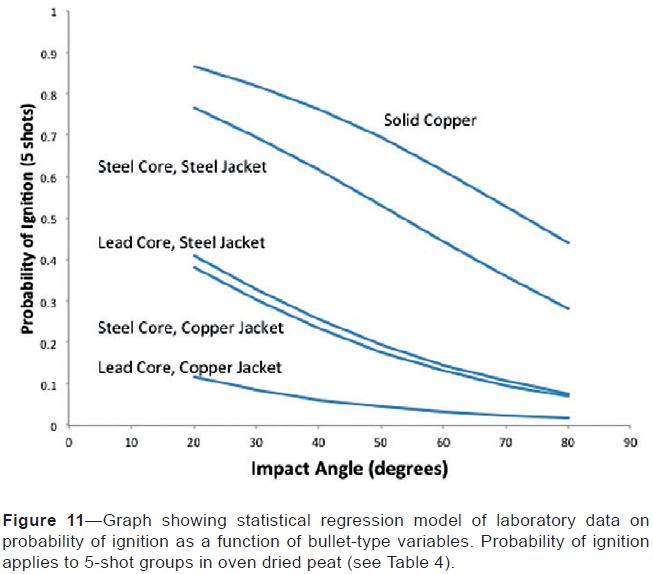
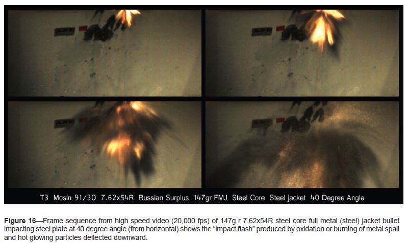
In research that was published in August, it was found that all types of rifle bullets studied were capable of starting fires in vegetation after being deflected by a steel plate. Fragments of most of the bullets that scientists at the U.S. Forest Service Rocky Mountain Research Station collected in a bed of peat moss reliably caused ignitions, specifically those containing steel components (core or jacket) and those made of solid copper. Lead core-copper jacketed bullets caused only one ignition in these tests. Solid copper bullets were the most consistent in producing ignitions at all angles and all targets.

Many wildfires are caused by target shooting, so it is helpful to have some actual data examining how they are ignited and by what type of ammunition. Lead core copper jacket bullets appear to have a low probability of starting fires.

While the military has conducted numerous studies on bullet fragmentation, this is the first time that researchers have looked at the probability of ignition (PI) in vegetation.

This research shows that fires can be ignited by hot fragments of the bullets due to the heat generated when the kinetic energy of the lead, copper, or steel is transformed to thermal energy by plastic deformation and fracturing from the high-strain rates during impact. Lead has a lower melting point than copper or steel, which contributes to the lower PI of lead core bullets.

Probability of ignition of bullets

In the study a high-speed video camera was used at frame rates of 8,000 to 100,000 frames per second to attempt to capture impact fragmentation and impact flash. Usually the camera was positioned from behind the bullet as it was fired. Researchers found that a camera placed in front of the bullet lasted only one series before being destroyed by a fragment.

The study was conducted by Mark A. Finney, Trevor B. Maynard, Sara S. McAllister, and Ian J. Grob.

Below is a video shot by a company that sells a 1,000,000 frame per second camera, showing bullets striking various objects. We are hoping to gain access to the video shot by the USFS researchers. If we do, we’ll post it here.


Thanks go out to Ken

Large group of researchers hopes to develop more accurate fire models

RXCADRE
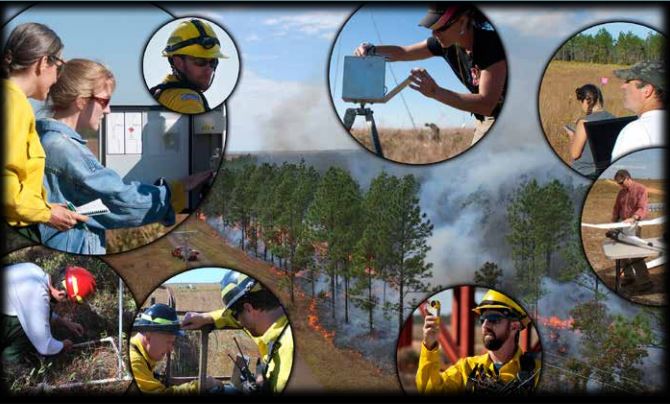
From the RxCADRE overview report.

“Fire science is not rocket science—it’s way more complicated.”

That quote comes from research ecologist Matt Dickinson of the U.S. Forest Service’s Northern Research Station who borrowed it from Robert Essenhigh, Professor Emeritus, Mechanical and Aerospace Engineering, Ohio State University. Mr. Dickinson was one of 36 researchers who collected data over a two week period during a series of extensively instrumented prescribed fires at Eglin Air Force Base in the Florida Panhandle last year.

The Joint Fire Science Program organized and helped fund the project, called RxCADRE, which collected 10 terabytes of data using many, many ground based sensors and four orbiting aircraft. Their goal was to obtain a comprehensive dataset of fire behavior, fire effects, and smoke chemistry, using measurements taken systematically at multiple, cascading scales. The information will help scientists and fire modelers test their models and develop better ones, ultimately making them more reliable.

Part of the project included hiring a writer to produce a 12-page overview of their work. It provides a great deal of information about how they planned and conducted the field work, and is for the most part well-written and worth reading, but occasionally lapses into flowery language for the sake of … flowery language.

For example,

36 scientists watch as fire’s ancient energy is captured, photographed, mapped, sensed, counted, measured, weighed, and rendered into data.

and,

The fire catches, wavers, and bellies gently before the wind. It spreads unevenly, then comes together, licking the grasses.

The Joint Fire Science Program deserves kudos for organizing this important research and for arranging to produce the 12-page overview.

Better satellite imagery enables improved wildfire mapping and growth predictions

Higher resolution imagery becoming available from satellites will enable more accurate mapping and spread prediction of wildfires.

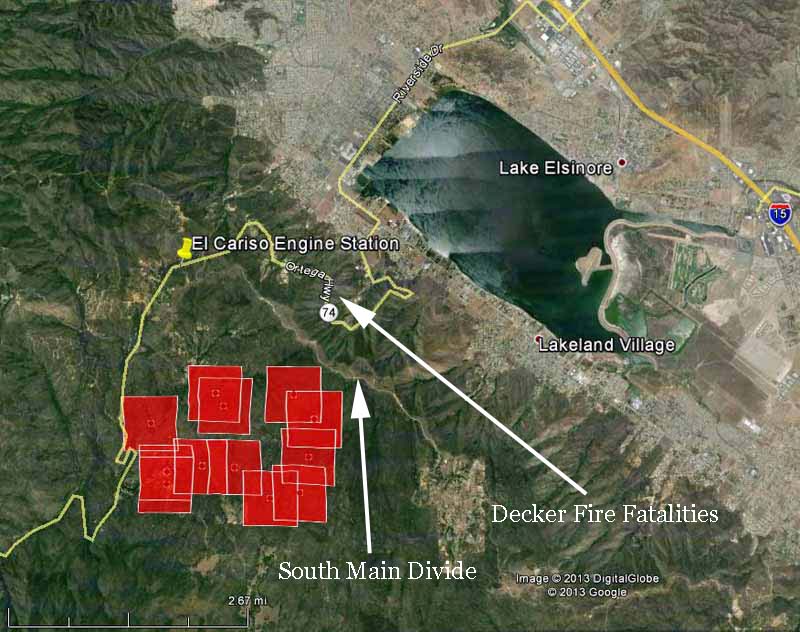
Higher resolution imagery becoming available from satellites will enable more accurate mapping and spread prediction of wildfires. Since we created Wildfire Today in 2008 we have frequently displayed maps showing fire data collected by the Moderate-resolution Imaging Spectroradiometer (MODIS) instrument package, such as the one below of the Falls Fire near Elsinore, California in August. The red squares represent heat detected by MODIS before the fire spread east across the South Main Divide and down through the bowl where the Decker Fire fatalities occurred in 1959. Click on the image to see a larger version.

Map of Falls Fire at 1:47 p.m. PDT, August 5, 2013
Map of Falls Fire at 1:47 p.m. PDT, August 5, 2013, showing heat detected by a satellite. The red squares indicating heat can be as much as a mile in error. (click to enlarge)

MODIS, launched in 1999 with its 1,000-meter resolution system, is starting to show its age. Better technology is now available and is orbiting 512 miles above the Earth on the Suomi National Polar-orbiting Partnership (Suomi NPP) satellite launched October 28, 2011 . The Visible Infrared Imaging Radiometer Suite (VIIRS) on the satellite is a 22-band radiometer designed to collect infrared and visible light data to observe wildfires, movement of ice, and changes in landforms. It has a resolution of 375 meters, much better than the MODIS. The new Landsat 8 satellite launched in February has a resolution of 30 meters for most of its sensors, and 100 meters for thermal infrared. This will be a game changer. In March we published a test image of the Galena Fire taken with Landsat 8.

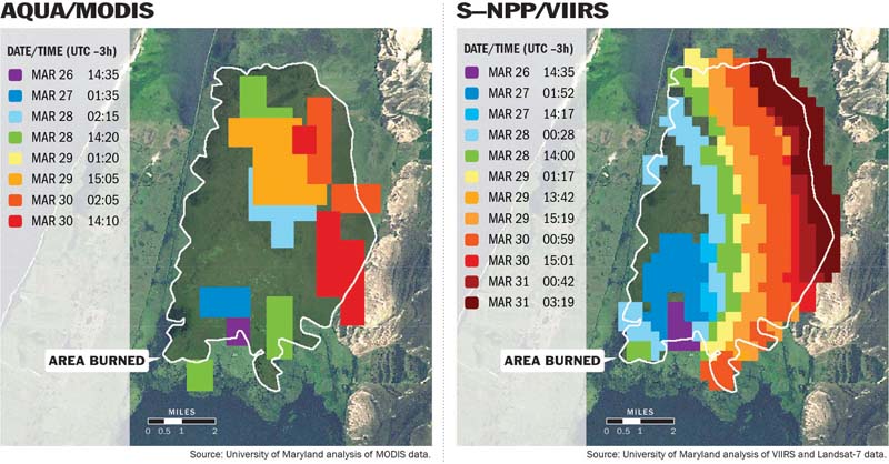
Below is a comparison of data from MODIS and VIIRS. Click on it to see a larger version.

VIIRS vs MODIS
When observing wildfires, satellites provide different levels of detail, depending on which instrument is used. The image at left, produced from data generated by the MODIS instrument aboard NASA’s Aqua satellite, uses 1-kilometer pixels (a bit over half a mile across) to approximate a fire burning in Brazil from March 26 to 30, 2013. The image at right, produced with data from the new VIIRS instrument, shows the same fire in far greater detail with 375-meter pixels (a bit over 1,200 feet across). (Image courtesy Wilfrid Schroeder, University of Maryland.)

Last month we told you about a proposed satellite, called FUEGO – Fire Urgency Estimator in Geosynchronous Orbit, which would survey the entire western United States every two minutes or less and could detect a fire that is about 10 feet in diameter. Assuming that the data from the satellite could be transmitted to the appropriate dispatch center within a minute or two, this could be a major step toward keeping fires small… IF the fire agencies have the appropriate initial attack policies in place and an adequate number of firefighting resources, both ground and air-based, to respond and arrive at the fire within the first 10 to 30 minutes. But since the cost of the satellite could be several hundred million dollars, it probably will never be built or launched.

Two scientists who have been working with some of the new data that is available now are Janice Coen of the National Center for Atmospheric Research in Boulder, Colorado, and Wilfrid Schroeder with the Department of Geographical Sciences, University of Maryland. They intend to transition the new refined spatial resolution VIIRS and Landsat-8 fire detection data and a new weather forecast-fire spread model into operations in the next two to three years. Mr. Schroeder told us that some of the higher resolution data should replace the MODIS data on the GEOMAC website in the next one to two months. In the meantime you can see some early versions of it on an experimental basis at a website they created.

The two of them recently published a paper documenting the development of a new wildfire spread model (think newer version of BEHAVE) that, coupled with high resolution numerical weather prediction and the actual location of a fire as detected by the 375-meter resolution VIIRS, predicts the fire behavior and spread of a fire, displaying it on a map. The model can be run after the overflights of the satellite every 12 hours using updated weather forecast information and the current location of the fire.

Their paper is HERE, and a description of the concept written by Ms. Coen is below.
Continue reading “Better satellite imagery enables improved wildfire mapping and growth predictions”

Learning Review released for smokejumper fatality

A report called a “Learning Review” has been released for the Luke Sheehy fatality, the smokejumper who was killed by a falling limb while suppressing a wildfire on the Modoc National Forest in northeast California on June 10. In addition to the primary report an additional document with supporting information, including some mind-numbing charts, was released.

The objective as stated in the document was to “understand the rationale for the actions/decisions involved in the incident and then, if possible, to learn from them”.

Frequently at Wildfire Today we will write a summary and then our analysis of serious accident reports, but this particular document is very different from the traditional report. It adopts the new paradigm of leaving out conclusions and recommendations, a process that began to be etched into stone in August when the Serious Accident Investigation Guide was revised. This Learning Review claims that “conclusions can sometimes close the door on learning”. I would say on the other hand that they can more frequently open the door to an enhanced safety environment for firefighters. People can sometimes be hit by meteorites, but not often.

And like virtually every research paper, most of the recommendations are for additional studies, ensuring continued employment for academics and researchers.

Call me old school, but this document appears to be more useful for human behavior researchers than firefighters. How did we get to the point where language such as this is used repeatedly in a U.S. Forest Service funded official report about a wildland fire?

  • “Typical mission flow”
  • “Synthesis, analysis and sensemaking”
  • “Margin of maneuver”
  • “Sensemaking team”
  • “Single Loop vs. Double Loop Learning”
  • “Hoberman Sphere”
  • “Pressures and filters”
  • “Mind maps”
  • “Auditory signal”
  • “Signal detection”

The Learning Review does suggest that two additional products be prepared, one for “the field” and another for “the organization”. Maybe the field document, if produced, will be more useful for firefighters. And presumably the organization version will have conclusions and recommendations that will remain secret if the guidelines revised in August are followed.

I am not sure why the U.S. Forest Service paid the 22 people, plus multiple focus groups, to produce this study if they did not receive for their investment products usable by the field or the organization.

But I am old school when it comes to opportunities for learning lessons.

Wildfire briefing, November 4, 2013

After the Rim Fire, water now worries land managers

The 257,000-acre Rim Fire is now 100 percent contained, at a cost of $127 million, but the effects of rain on barren slopes is the newest worry for land mangers. Over 90 percent of the fire burned in the Tuolumne River watershed in and near Yosemite National Park in California. The loss of vegetation and exposure of the soil could lead to erosion and increased water runoff that may lead to flooding, increased sediment, and debris flows.

The Burned Area Emergency Response (BAER) team has been working in the Rim Fire area for weeks and continues to assess the needs and implement emergency stabilization measures. Projects the team is working on include:

  • Improving road drainage and storm-proofing roads at risk of failure from increased flooding.
  • Stabilizing and repairing trails.
  • Monitoring for and treating invasive weeds.
  • Mulching and chipping to protect fragile soils.

Two dry years in a row have worried land managers but now the thought of a heavy rain has them concerned.

Acid frogs are not greatly affected by fires

Often we hear of people who suffer mental anguish over the plight of animals being affected by wildfire — they assume that Bambi and others die by the thousands. But most creatures have adapted to fire over tens of thousands of years.

Recent research in Australia concluded that acid frog “populations did not suffer adversely from moderate intensity fires as suitable refuges, including standing water, were available. All species were present shortly after fire with subsequent successful reproduction occurring once wetlands were sufficiently inundated.”

You can obtain a copy of the taxpayer-funded research by paying the International Journal of Wildland Fire, published by CSIRO, $25. The researchers work for Griffith University, which apparently does not believe in the concept of Open Access to taxpayer-funded research.

New Hampshire may ban fire balloons

New Hampshire may become the 26th state to ban fire balloons, which are sometimes called sky lanterns or Chinese lanterns.

These incendiary devices use burning material such as rubbing alcohol or a candle to heat the air in a bag made of tissue paper or very thin plastic. The heat makes the device lighter than air causing it to rise into the sky, staying aloft for 10 minutes to 2 hours. They can be very pretty to watch especially when they are released dozens or hundreds at a time such as at a wedding or some other celebration. The  problem is they are uncontrollable and sometimes start wildfires or structure fires.

The National Association of State Fire Marshals adopted a resolution this year urging states to ban the sale and use of the devices. Below is an excerpt from their position on the issue:

…Therefore, be it resolved that the National Association of State Fire Marshals strongly encourages states to ban the sale and use of sky lanterns through whichever means is most expedient for them. Banning the use of sky lanterns is important to help control homemade devices as well as those purchased from various sources.

New Hampshire state Senator Nancy Stiles has introduced a bill to prohibit them in her state. Below is an excerpt from USA Today:

Stiles, a Republican, filed her bill at the request of Rye Fire Chief Skip Sullivan. Sullivan said people have lit the lanterns at the beach thinking they would float out to sea only to have them blow inland. One landed in a selectman’s yard but burned out and did no damage, he said.

Sullivan said fire officials want a law “primarily for the fact that when you light these and send them off, it is an open fire you’re sending off.”

He added, “When these things come down, are these people going to clean up the mess they leave behind?”


Researchers design satellite to detect wildfires — a step toward the Holy Grail of Firefighter Safety?

A concept for a satellite that would be dedicated to detecting new wildfires.

Researchers at Berkeley have designed a concept for a satellite that would be dedicated to detecting new wildfires. Decades ago we relied on a network of lookout towers staffed by employees and later volunteers who observed emerging fires and reported them by telephone or radio. Today most fires are turned in by residents or travelers with cell phones.

Dr. Gabbert’s prescription for keeping new fires from becoming megafires is:

Rapid initial attack with overwhelming force using both ground and air resources, arriving within the first 10 to 30 minutes when possible.

But if a fire is not detected and reported quickly, rapid initial attack is not possible.

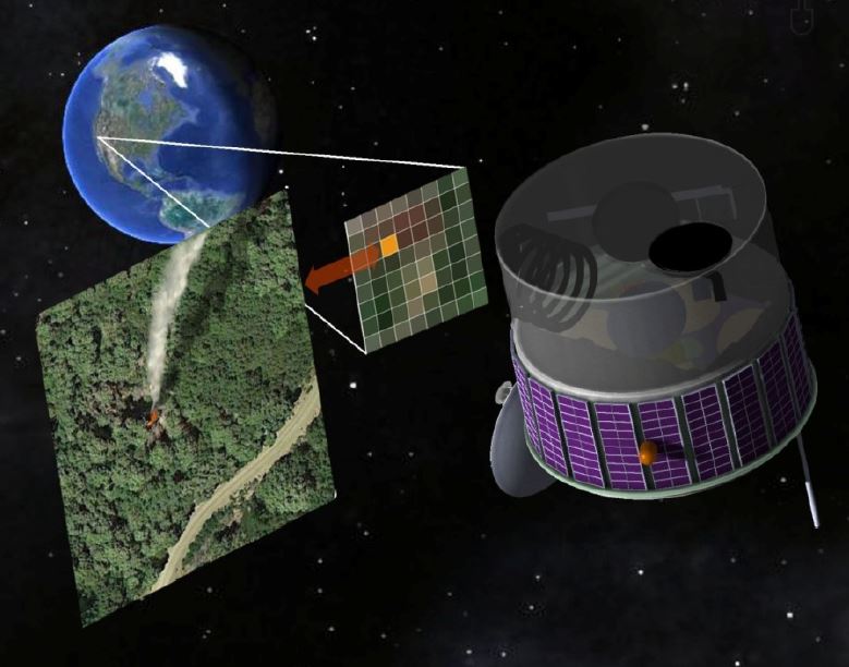
This proposed satellite, called FUEGO – Fire Urgency Estimator in Geosynchronous Orbit, would survey the entire western United States every two minutes or less and could detect a fire that is about 10 feet in diameter. Assuming that the data from the satellite could be transmitted to the appropriate dispatch center within a minute or two, this could be a major step toward keeping fires small… IF the fire agencies have the appropriate initial attack policies in place and an adequate number of firefighting resources, both ground and air-based, to respond and arrive at the fire within the first 10 to 30 minutes.

FUEGO satellite
Artist’s concept for FUEGO on orbit (FUEGO Concept Art by R. E. Lafever, LBNL)

While the cost of the satellite could be several hundred million dollars, it could conceivably save money if it prevents a few megafires like the Rim Fire in Yosemite National Park last summer that to date has cost more than $127 million.

The real time detection of new fires is a very worthy goal, but added to this system should be the capability for real time monitoring and mapping of existing fires. The Holy Grail of Wildland Firefighter Safety is a system that could track firefighters on the ground AND the location of the fire, all displayed on one screen. This data should be available in real time to key supervisors and decision makers in the Operations and Planning Sections on fires. Knowing the positions of personnel relative to the fire would be a massive step in improved situational awareness and could reduce the number of firefighters killed on fires. This information could have saved 24 lives in recent years — 19 on the Yarnell Hill Fire and 5 on the Esperanza Fire. In both cases the firefighters and their supervisors did not know where the firefighters were relative to the location of the fire.

All of this technology exists. It would be expensive to implement, but it could save lives.