The media is picking up on the fact that fighting wildfires is going to be even more hazardous during the pandemic

A wildland firefighter in Washington state has tested positive for COVID-19

36th Av fire masks wildfire covid-19
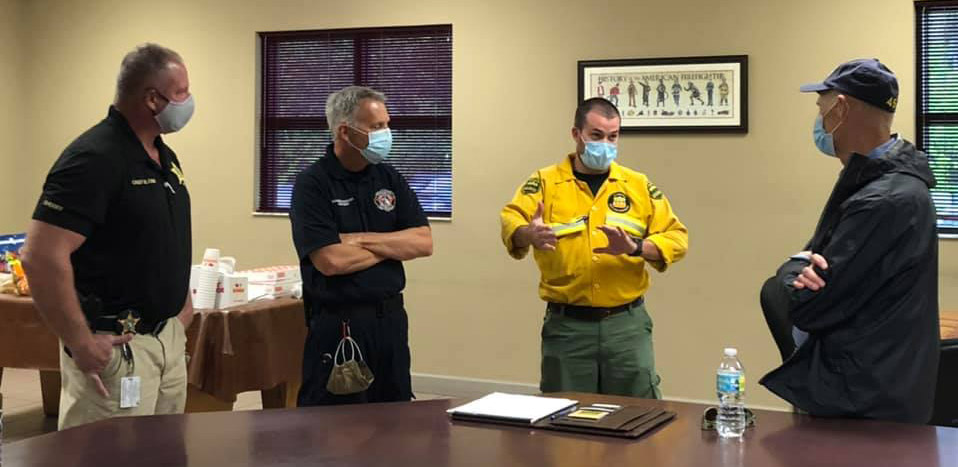
Personnel at the 36th Ave. SE Fire about 10 miles east of Naples, Florida posted May 15, 2020 by the Greater Naples Fire Rescue District.

In the last few days I have seen several articles in the media about how the COVID-19 pandemic increases the risk for wildland firefighters.


From the Associated Press, “Official: Busy wildfire season will be impacted by pandemic.”

…The coronavirus pandemic already reduced the amount of training for fire crews, and Franz said Washington can expect less assistance this year from federal agencies and other partners in battling wildfires.

The DNR has already recorded its first case of a firefighter testing positive for the virus, said Commissioner of Public Lands Hilary Franz. It was a seasonal firefighter in northeastern Washington.

To prevent additional cases, the state will embrace federal guidelines on social distancing and other reforms, said Jack Cates, chief of Spokane County Fire District 9 during a conference call with reporters.

“Fire camps will look a lot different this summer,″ Cates said. “They won’t be mini-cities like you usually see.″

Instead, firefighters will camp in smaller groups to limit contact with others, Cates said. They also will not be eating buffet-style in big kitchens.

Fire bosses also plan to rely more heavily on aerial assets to reduce the number of firefighters needed on the ground, said George Geissler, the Washington state forester.

Still, Geissler predicted that the number of firefighters will be in short supply because of the pandemic.

“It could be a significant impact to us,″ he said.


A piece in the New York Times describes a model the US Forest Service is using. On a fire with “hundreds of people”, their model predicts nearly two dozen will be infected with COVID-19, and there could be a 2 percent fatality rate among those infected. That 2 percent is a revision from the previous figure they were using, which was 6 percent.

The “hundreds of people” number is a little difficult to analyze, but if they meant 300, the prediction is that the fatality rate would be about 0.48 percent among all personnel on the incident. So if there are 1,000 people on the fire, approximately five would die, according to the model. Unacceptable!

“All models are wrong, but some are useful.”  (Statistician George Box, from a paper published in 1976)

From the Times article, “US Report Indicates Broad Risk of COVID-19 at Wildfire Camps”:

…The U.S. Forest Service’s draft risk assessment suggests that even in a best-case scenario — with social distancing followed and plenty of tests and protective equipment available — nearly two dozen firefighters could be infected with COVID-19 at a camp with hundreds of people who come in to combat a fire that burns for months.

The worst-case scenario? More than 1,000 infections.
The Forest Service said the document was outdated and being redone, and the newest version wasn’t yet ready to share. The AP obtained the draft from an official who has access to it and didn’t want to be named.

One of the authors of the risk assessment said Tuesday that in the new version, the infection rates remain the same. But while the draft originally said the death rate among infected firefighters could reach as high as 6%, that is being revised sharply downward, to less than 2%, to reflect newer data, said Jude Bayham, an assistant professor in the Department of Agricultural and Resource Economics at Colorado State University.


From The Conversation,  “Wildfire smoke worsens coronavirus risk, putting firefighters in extra danger”:

…Italian scientists reported in 2014 that air pollutants can increase the viral load in the lungs and reduce the ability of specialized cells called macrophages to clear out viral invaders.

Researchers in Montana later connected that effect to wood smoke. They found that animals exposed to wood smoke 24 hours before being exposed to a pathogen ended up with more pathogen in their lungs. The researchers showed that wood smoke exposure decreased the macrophages’ ability to combat respiratory infection.

Now, new evidence suggests that long-term exposure to PM2.5 air pollution, which is produced by sources such as wildfirespower plants and vehicles, may make coronavirus particularly deadly.

Researchers from the Harvard T.H. Chan School of Public Health conducted a nationwide study of county-level data and found that even a small increase in the amount of PM2.5 from one U.S. county to the next was associated with a large increase in the death rate from COVID-19. While small increases in PM2.5 also raise the risk of death from other causes for older adults, the magnitude of the increase for COVID-19 was about 20 times greater. The results were released last week, before the usual peer review process was conducted, to help warn people of the risks.

Taken together, these findings suggest that air pollution, including wood smoke, could increase the risk that wildland firefighters will develop severe COVID-19 symptoms.

That probably doesn’t surprise seasoned firefighters.


From the New Mexico Political Report, “COVID-19 complicates 2020 fire season”:

The article begins by recounting the incident within an incident on the 2017 Frye Fire near Safford, Arizona. A doctor swabbed the throats of 80 firefighters, with 63 (or 78 percent) testing positive for Streptococcus (strep throat). Thankfully strep can usually be cured within days or weeks.

Then the article moves on to this year and COVID-19:

…In New Mexico, the state’s Forestry Division is adapting much like its national counterpart. The Forestry Division, which manages 43 million acres, worked with local and tribal partners to create new guidelines for their staff, said Vernon Muller, resource protection bureau chief with the New Mexico Department of Natural Resources.

Those include self-screenings at the start, middle, and end of every shift, even while on active fire assignments, for any signs of sickness. Only two individuals will ride in an engine while a string of chase vehicles transports the rest of the crew.

Crew buggies will carry a fraction of their capacity. Temperature tests will be taken. Meals will be packaged individually instead of served buffet-style. Already, Muller said, two individuals declined an assignment after their self-assessment questionnaire found they or their family members may have been exposed to coronavirus.

But these choices create tradeoffs. Some say it’s still not possible to keep six feet apart, and crowding the roads with almost twice as many vehicles creates a hazard of its own and doubles the workload when it’s time to sanitize trucks and equipment.

And because firefighters are paid only when on-assignment, passing on an assignment because they suspect exposure to COVID-19 cuts into their paycheck.

Thanks and a tip of the hat go out to Karen. Typos or errors, report them HERE.

Analysis of 53 firefighter injuries during tree falling operations

Tree felling injuries
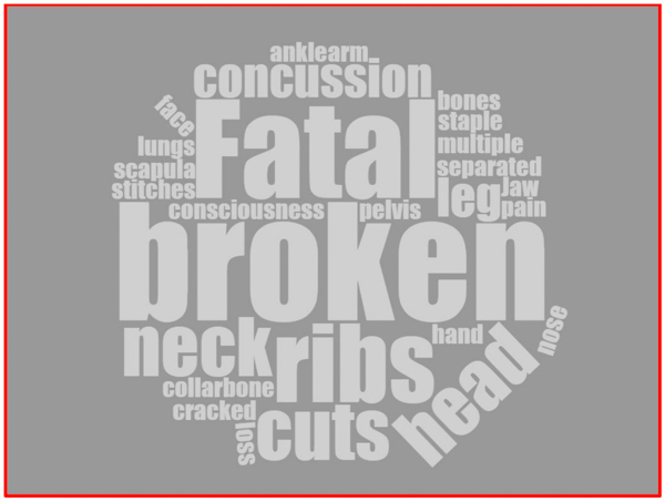
This “word cloud” was generated using the injury descriptors from the 53 incidents included in the analysis. The size of a word indicates its relative frequency. (From the report)

The report on the tree falling incident in which Captain Brian Hughes of the Arrowhead Hotshots was killed in 2018 recommended that an analysis of tree falling accidents be conducted “to assist in setting priority actions to reduce similar incidents.”

Captain Hughes died when a 105-foot tall Ponderosa Pine fell in an unexpected direction on the Ferguson Fire on the Sierra National Forest near Yosemite National Park in California.

A Tree Falling Accident Analysis was completed by the Wildland Fire Lessons Learned Center at the request of the the U.S. Forest Service and the National Park Service. Their study compares 53 incidents from 2004 to 2019 in which firefighters were injured or killed in the process of falling trees.

Anyone involved in tree falling should read the entire 17-page report, but here are some of their findings:

  • 53% of the time the tree fell in the intended direction.
  • 28% of the time, the tree impacted another tree during its fall—including 2 of the 8 fatalities.
  • 19% of the time, the top broke out and came back—including 2 of the 8 fatalities.
  • Of all the reports that included recommendations, 21% recommended enhancing training related to tree conditions (like rot) and species-specific traits.
  • 19% of the time, the sawyer was working on a hung-up tree— including two of the eight fatalities.
  • 51% of the time, the incident involved a direct helmet strike.
  • Of the reports that include recommendations, 24% recommended research and development related to wildland fire helmets.
  • 42% of the time, the person struck was not cutting—including in 5 of the 8 fatalities.
  • 24% of the reports recommended somehow improving safe work distance and compliance.
  • 40% of the time, the person struck was in the traditional escape route—including in 5 of the 8 fatalities.
  • 79% of the reports recommended improving risk assessment.
  • 13% of the time, the tree strike happened during training— including in 2 of the 8 fatalities.
  • 26% of the reports recommended improving faller training.
  • 21% of the reports recommended enhancing training related to tree conditions (like rot) and species-specific traits.

Jennifer Rabuck selected as NPS Wildland Fire Safety Specialist

The position has been vacant since 2017

Jennifer Rabuck
Jennifer Rabuck, will be the NPS Wildland Fire Safety Specialist. (NPS Photo)

Jennifer Rabuck, a U.S. Forest Service zone fire management officer (FMO) on the Chequamegon-Nicolet National Forest in Hayward, Wisconsin, has been named as the wildland fire safety specialist for the National Park Service Branch of Wildland Fire. Jennifer fills the vacant position left when Chad Fisher became the wildland fire operations program leader in 2017.

Jennifer began her federal service on the Clearwater National Forest in Idaho in 1994 and moved into her first permanent full-time fire management position in 2002 at the Leopold Wetland Management District in Wisconsin. She gained experience as a prescribed fire specialist with the U.S. Fish and Wildlife Service before moving into her current position as zone FMO. Jennifer has detailed as the assistant forest FMO on the Superior National Forest and as a National Incident Management Organization Safety Officer. Her experience with facilitated learning analysis teams, as a national cadre member for the You Will Not Stand Alone course, as a family/hospital liaison, and with planning for critical incidents will be a great addition to the NPS.

“I’m very excited to have Jennifer join the Wildland Fire Operations Program” said Program Leader Chad Fisher. “She brings a depth and breadth of experience, along with a fresh perspective, to our work serving the parks and regions of the National Park Service and in our interagency endeavors.”

Jennifer will relocate to Boise, ID and begin her new duties March 29, 2020.

New real time mapping system used on Cave Fire

Fire Integrated Real-Time Intelligence System (FIRIS)
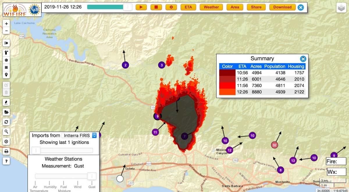
An example of an output from the Fire Integrated Real-Time Intelligence System (FIRIS) used on the Cave Fire near Santa Barbara, CA November 26, 2019. The dots with arrows represent weather stations. Inciweb.

A new real time wildfire mapping system was used on the Cave Fire near Santa Barbara, California this week.

In September the Orange County Fire Authority began a 150-day pilot program to use and evaluate the Fire Integrated Real-Time Intelligence System (FIRIS). The program got off the ground thanks to funding secured in the 2019-2020 California state budget by Assemblywoman Cottie Petrie-Norris (D-Laguna Beach).

The system utilizes a fixed-wing aircraft equipped with infrared and radar sensors that can see through smoke. The plane provides real-time fire perimeter mapping and live high definition video to support supercomputer-based wildfire predictive spread modeling.

(Click here to see all articles on the Cave Fire, including the most recent)

FIRIS fire wildfire mapping real time
Screenshot of aircraft featured in the FIRIS B-Roll video.

A supercomputer at the University of California San Diego runs WIFIRE spread projections based on fire perimeter data collected by the aircraft. The output estimates where the fire will be in the next six hours. The fire spread model adjusts for successful fire suppression actions by firefighters on the ground and in the air. This intel allows for more timely and accurate decision making for resource allocation and evacuations.

flight path N4717V fire mapping
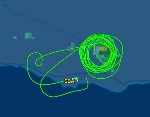
The flight path of N4717V, a Turbo Commander 690, also known as “AC90”. It was orbiting over the Cave Fire at 12,400 feet on November 26, 2019. Flightaware map.
AC90 mapping aircraft wildfire
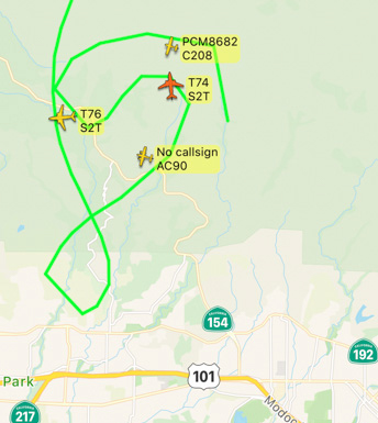
The FIRIS aircraft, shown as “AC90”, was over the Cave Fire along with two S-2T air tankers, at 7:52 a.m. November 26, 2019. Flightradar24

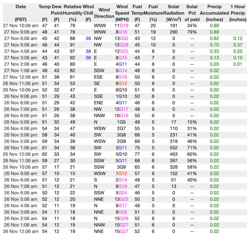
If I am correctly interpreting the WIFIRE product at the top of this article the system predicted that the Cave Fire would grow from 4,994 to 8,880 acres over a 90-minute period beginning at 10:56 a.m. on November 26, 2019. Spot fires were predicted more than a mile ahead. However, decreasing winds that day slowed the spread. A weather station in San Marcos Pass about three miles northwest of the fire recorded sustained wind speeds from 1 to 5 mph between 10 a.m. and 5 p.m. Rain beginning at 2 a.m. November 27 stopped  the spread at 4,330 acres.

Weather San Marcos Pass
Weather at San Marcos Pass, November 26-27, 2019.

The video below is “B-Roll”, that is, unedited footage of the FIRIS system. The first 6.5 minutes are simply images of aircraft, but after that you will be able to look over the shoulder of the imagery technician as he observes infrared imagery of a fire, manually interprets the heat signatures, then traces the fire perimeter on the screen. That perimeter could then be electronically sent to the super computer in San Diego County which would run a fire spread model to predict what the fire will do in the next six hours.

Our attempts to obtain more information about FIRIS from personnel on the Cave Fire that used the system were not successful.

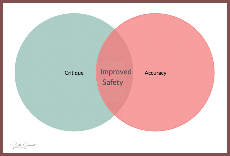
Accuracy and Critique

Critique vs accuracy venn diagram

When a wildland fire incident has a controversial outcome it will often be pointed out by those who are knowledgeable on the subject, or by someone who is directly or indirectly affected.

I understand how venting can be cathartic. As long as it is done in private, no problem. If it is done in public there can be cascading repercussions, and therefore more responsibility. At worst, it can be self-serving, cruel, damaging, and counterproductive. But if everything said is completely accurate, and the result can benefit mankind, then the greater good might be served in many situations. At Wildfire Today, I know that sunlight can be the best disinfectant. Helping shine a little light on lessons learned by firefighters through information about reports being released or critique from various sources, might reduce the chances of someone else learning a lesson the hard way — with unpleasant consequences.

Years ago in a comment section on Wildfire Today someone made statements about another person. It was slanderous, not true, and damaged the reputation of a very honorable and skilled professional. Since then I have strived harder to have factual information on the web site. There are times when that objective is not met, but it does not stop me from trying.

Even the best intentioned formal investigations of incidents may occasionally miss the mark of being accurate. Other times the report an investigation team releases might purposefully deceive, or lie by omission. I certainly do not have all the answers, not by a long shot. In cases like these, and others, attention is needed by the hive mind of the wildland fire community.

Critique not meshing with accuracy can keep me up at night.

Attempting to redefine the common denominators of tragedy fires

“A Classification of US Wildland Firefighter Entrapments Based on Coincident Fuels, Weather, and Topography”

Above: Figure 1 from the research paper. Distribution of 166 US wildland firefighter entrapments that occurred within CONUS (1981–2017) by time of day (local time) and month of the year.

On October 9, 2019 a document was published that summarized the work of four researchers who sought to find commonalities that led to the entrapments of firefighters on wildland fires. The paper is titled, “A Classification of US Wildland Firefighter Entrapments Based on Coincident Fuels, Weather, and Topography.” Apparently they were hoping to confirm, fine tune, revise, or update the “Common Denominators of Fire Behavior on Tragedy Fires” defined by Carl C. Wilson after the 1976 Battlement Creek Fire where three firefighters were killed near Parachute, Colorado.

Mr. Wilson developed two lists, one with four items and another with five. Here is the five-item list:

  1. Most of the incidents occurred on relatively small fires or isolated sectors of larger fires.
  2. Most of the fires were innocent in appearance prior to the “flare-ups” or “blow-ups”. In some cases, the fatalities occurred in the mop-up stage.
  3. Flare-ups occurred in deceptively light fuels.
  4. Fires ran uphill in chimneys, gullies, or on steep slopes.
  5. Suppression tools, such as helicopters or air tankers, can adversely modify fire behavior. (Helicopter and air tanker vortices have been known to cause flare-ups.)”

The four more recent researchers conducted an analysis of the environmental conditions at the times and locations of 166 firefighter entrapments involving 1,202 people and 117 fatalities that occurred between 1981 and 2017 in the conterminous United States. They identified one characteristic that was common for 91 percent of the entrapments — high fire danger — specifically, when the Energy Release Component and Burning Index are both above their historical 80th percentile.

They also generated an update of the time of day the entrapments occurred as seen in the figure at the top of this article. This has been done before, but it’s worthwhile to get an update. And, this version includes the month.

You can read the entire open access article here. If you’re thinking of quickly skimming it, the 7,000 words and the dozens of abbreviations and acronyms make that a challenge. There is no appendix which lists and defines the abbreviations and acronyms.

The authors of the paper are Wesley G. Page, Patrick H. Freeborn, Bret W. Butler, and W. Matt Jolly.

Below are excerpts from their research:


…Given the findings of this study and previously published firefighter safety guidelines, we have identified a few key practical implications for wildland firefighters:

  1. The fire environment conditions or subsequent fire behavior, particularly rate of spread, at the time of the entrapment does not need to be extreme or unusual for an entrapment to occur; it only needs to be unexpected in the sense that the firefighters involved did not anticipate or could not adapt to the observed fire behavior in enough time to reach an adequate safety zone;
  2. The site and regional-specific environmental conditions at the time and location of the entrapment are important; in other words, the set of environmental conditions common to firefighter entrapments in one region do not necessarily translate to other locations;
  3. As noted by several authors, human factors or human behavior are a critical component of firefighter entrapments, so much so that while an analysis of the common environmental conditions associated with entrapments will yield a better understanding of the conditions that increase the likelihood of an entrapment, it will not produce models or define characteristics that predict where and when entrapments are likely to occur.

[…]

The one characteristic that was common for the majority of entrapments (~91%) was high fire danger. As a general guideline, regardless of location, the data suggest that entrapment potential is highest when the fire danger indices (ERC’ and BI’) are both above their historical 80th percentile. Until recently, spatially-explicit information on fire danger has not been widely available as most firefighters have relied on fire danger information available at specific weather stations, which are often summarized into Pocket Cards [83]. Fortunately, fire danger forecasts across CONUS are now available in a mobile-friendly format (see https://m.wfas.net) that can be displayed spatially for each of the fire danger indices separately or combined into a Severe Fire Danger Index.

[…]

Conclusions

The times and locations where wildland firefighter entrapments occur in the US cover a wide range of conditions. Current firefighter safety guidelines seem to emphasize only a subset of the possible conditions due to a focus on the factors that maximize the potential for extreme fire behavior. While many of these safety guidelines are still intuitively valid, caution should be exercised during relevant firefighter training so as to not ignore or undermine the fact that entrapments and fatalities are possible under a much wider range of conditions.

Despite the wide range of environmental conditions associated with entrapments, we have shown that it is possible to identify unique combinations of environmental variables to define similarities among groups of entrapments, but these will necessarily be context and site specific. For most entrapments, the only common environmental condition was high fire danger, as represented by fire danger indices that have been normalized to represent the historical percentile at a particular location. As such, at large spatial scales, fire danger and its association with fire weather should continue to be monitored and reported to firefighters using both traditional methods (i.e., morning fire weather forecasts) and also newer methods that take advantage of advancements in mobile technology.