Okanogan Complex continues to expand, pushed by strong winds

(UPDATED at 4 p.m. PT, August 22, 2015)
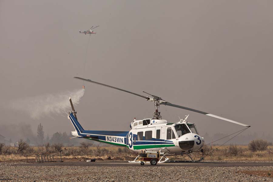
Helicopters at Okanogan Complex of Fires
The arrival of the predicted dry cold front on August 21st, 2015 brought strong winds to the Okanogan Complex of fires and drove part of the blaze into an area near the Okanogan airport where a K-Max helicopter performed bucket work in an area near one of the Washington DNR UH-1 Hueys. Two of the DNR ships joined the K-Max and a civilian Blackhawk in the engagement. Photo by Tom Story.

The Okanogan Complex of fires was very active again on Friday as a cold front with strong winds passed through the area. According Incident Commander Todd Pechota (via Joe O’Sullivan) more than 227,000 acres have burned since the fires started on August 15. Additional evacuation orders were issued as the portion of the fire west of Okanogan spread south and approached and in at least one area crossed Highway 20, which is closed.
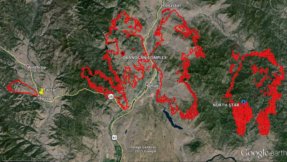
Map Okanogan Fire
Map of the Okanogan Complex of Fires. The fire perimeters shown were mapped at 9 p.m. on August 21. The red dots represent heat detected by a satellite during the 12 hours before 2:22 a.m. on Aug 22, 2015. (click to enlarge)
Washington UH-1 Huey Okanogan Complex of fires
A Washington DNR UH-1 Huey at the Okanogan airport takes off to engage the Okanogan Complex of Fires with some bucket work. Photo by Tom Story.

On Friday, President Obama signed an emergency declaration, ordering federal aid to assist in battling Washington state’s wildfires. The declaration allows FEMA to coordinate disaster relief efforts in Asotin, Chelan, Douglas, Ferry, Klickitat, Okanogan, Pend Orielle, Skamania, Spokane, Stevens, and Yakima counties. It also brings aid to the Colville, Spokane, Kalispel, and Yakima tribes.

For the first time, volunteers are being asked to fight the fires. More than 3,000 people have called and emailed in response to the state’s request for volunteer help with wildfires.

Dino sent us this link to four webcams in the Methow Valley between Twisp and Winthrop, Washington. He said they refresh once an hour. When I checked them Saturday afternoon they were shrouded in smoke.

****

(UPDATE at 9:47 a.m. PT, August 21, 2015)
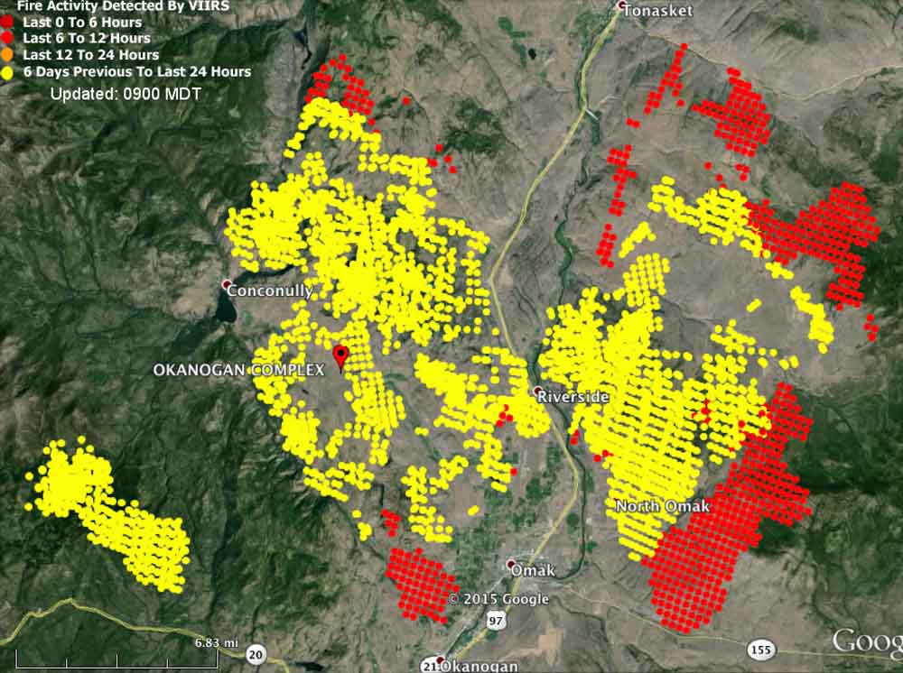
Map Okanogan Fire
Map showing heat detected on the Okanogan Fire by a satellite at 3 a.m. PT August 21, 2015.

The Okanogan Complex of Fires consumed another 40,000 acres of vegetation on Thursday and now covers 124,083 acres, crossing the 100,000-acre threshold to obtain megafire status.

****

(Originally published at 2:58 p.m. PT, August 20, 2015)
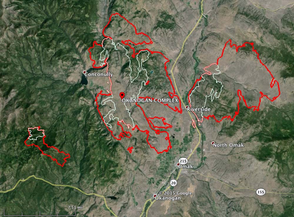
map Okanogan Complex
The red line was the fire perimeter of the Okanogan Complex at 11 p.m. PT August 19, 2015. The white line is from about 24 hours before. (click to enlarge)

The Okanagan Complex, comprised of 11 fires, some of which grew together, quadrupled in size on Wednesday. It added 60,282 acres and as of 11 p.m. Wednesday night it was 83,441 acres and still growing rapidly (see map above). The Twisp River Fire, on which three firefighters were killed Wednesday, was added to the Complex this morning. A Type 1 incident management team will inbrief on Thursday.

The fire is near Omak, Riverside, and Okanagan in north-central Washington.

The area is under a Red Flag Warning through Friday (see map below) for continued warm temperatures, low humidities and strong north winds on Friday that could reach 50 mph — possibly downing power lines that could start new fires.

wildfireRed Flag Warnings, August 20, 2015

Washington Governor and FS Chief discuss the firefighter fatalities

This morning at 11 a.m. PT Washington Governor Jay Inslee and U.S. Forest Service Chief Tom Tidwell conducted a news conference at the fire station in Chelan, Washington. They discussed the general fire situation in the Northwest, and mentioned the three USFS firefighters who were killed near Twisp, Washington the day before, on August 19.

Firefighters standing by at Twisp as the killer fire approaches

Twisp fire, August 19, 2015The fire that killed three firefighters on Wednesday is still very active and is heading toward the town of Twisp, Washington. The above tweet was sent by KHQ reporter Gabe Cohen at 10 Wednesday night. It sounds like firefighters in the town are going to have their hands full. The entire town and the nearby community of Winthrop are under evacuation orders affecting 3,000 people.

Twisp fire - August 19, 2015

And the weather will not be their friend. Red Flag Warnings are posted for the area through Friday night for strong winds. The chart below (click on it to see a larger version) predicts that Wednesday night the wind at Twisp will be from the northwest at 15 to 17 mph with gusts to 24 mph, pushing the fire closer to the town. It will decrease to 6 to 15 during the day on Thursday and then crank up again Thursday night with gusts up to 22 mph. Friday a cold front will move through but the relative humidity will remain fairly low and the winds will be even stronger, gusting to 28 mph.

Twisp wind and weather

Three firefighters killed in Washington wildfire

(Originally published at 6:12 p.m. PT, August 19, 2015; updated at 8:12 a.m. PT, August 20, 2015)

Three U.S. Forest Service firefighters were killed Wednesday, August 19, while they were fighting the Twisp River fire west of Twisp, Washington. The agency confirmed that they were “engaged in initial attack operations and were involved in a vehicle accident when it is believed that the fire overtook the vehicle.”

According to Okanogan County Sheriff Frank Rogers, the three Forest Service deaths occurred in a fire on Washington Department of Natural Resources land.

Four additional firefighters were injured: one USFS, two DNR, and one DNR contractor.

Evacuations of the 3,000 residents of two nearby towns were ordered, Twisp and Winthrop.

The names have not been released, pending notification of next of kin.

“We are devastated by the tragic loss of three of our Forest Service firefighters,” said Mike Williams, Forest Supervisor on the Okanogan-Wenatchee National Forest.  “We are working with County and State partners to notify the families of those lost.  Our hearts and prayers go out to the families and fellow crewmembers of these brave firefighters.”

The Forest Service said a national incident management team has been ordered.

Q13 Fox reported that the county “sheriff said the wind suddenly shifted and the firefighters became trapped as the fire was turned back on them”.

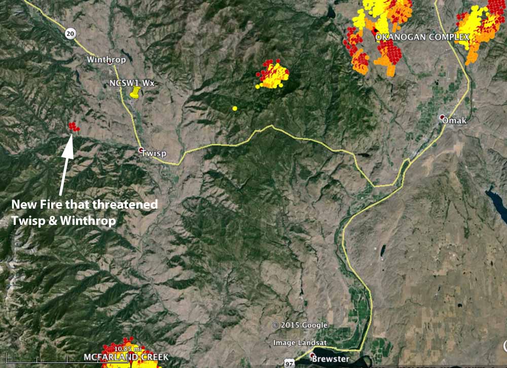
The rapidly spreading new fire that caused the evacuations is represented by the six red dots in the map below, 6 miles northwest of Twisp. Heat from the fire was detected by a satellite at 1:05 p.m. PT, August 19. Click on the map to see a larger version.

Map fires near Twisp
Fires near Twisp, Washington. The dots represent heat detected by a satellite, with the red ones being the most recent, recorded at 1:05 p.m. PT on August 19, 2015. (click to enlarge)

Evacuation information can be found at the Okanogan County Emergency Management Facebook page.

The first articles to report the fatalities were time-stamped shortly before 6 p.m. PT, August 19.  The reports say shifting winds may have contributed to the entrapment of the firefighters. The weather station between Twisp and Winthrop, NCSW1, between 8 a.m. and 5 p.m. on Wednesday recorded winds from all directions, starting from the north at 8 a.m., the wind direction changed going clockwise until they were from the north-northwest at 5 p.m. The wind speeds were light, at 1 to 6 mph until 5 p.m. when they increased to 10 with gusts to 20 mph. The relative humidity was in the mid-teens and the high temperature was 95 degrees.

Our sincere condolences go out to the families of the injured and deceased firefighters.

Deputy IC on Wolverine Fire describes the competition for firefighting resources nationally

Five new lightning-caused fires started Friday that surrounding Chelan, Washington, threatened homes in the city, then some of them joined forces and crossed the Columbia River. Our main article about the Chelan area fires is HERE (which is updated daily), but you may want to hear a portion of the back story of how wildfire organizations came up with a plan to deal with the quickly developing emergency during a time when the competition, nationally, for firefighters has become overwhelming.

In this video Rob Allen, the Deputy Incident Commander for the Wolverine Fire which is 30 air miles up Lake Chelan from the City by the same name, describes how his fire sent firefighting resources from their winding-down incident to assist with the initial attack of the five new fires near the city.

In the last one-third of the interview, Mr. Allen explains the nationwide shortage of firefighters and how the competition for resources is affecting firefighting in the Washington area and the rest of the West. As we reported earlier on Saturday, even though 554 20-person hand crews are currently working on wildfires in the western United States, there are outstanding orders for 160 more crews that are unable to be filled. Other important nationally-managed resources are already fully committed to ongoing fires and are completely unavailable for new fires, including transportable shower units and caterers that can set up in a remote area and begin feeding hundreds of hungry firefighters a few hours after they arrive in a dusty field near a fire.

Update on the fire situation in Washington and Oregon

The Regional Office in U.S. Forest Service Region 6, comprised of Washington and Oregon, distributed an update on the wildfire situation to USFS retirees. Below are some excerpts from the message, dated August 13.

****

“…As predicted, initial attack (IA) was heavy across the region yesterday and into today.  Many new and extended attack fires grew steadily, and in some cases, quite dramatically.  Wednesday saw 32 new fires in Oregon for 9,738 acres while Washington had 58 new fires for 1,426 acres. The most concerning of these is the Stickpin on the Colville National Forest .  There is continued concern for the National Complex, the Cornet/Windy Ridge, and Cougar Creek.  Four Type I teams are assigned in the region at the Wolverine Fire on the Okanogan-Wenatchee, the National Complex on the Rogue River-Siskiyou, Umpqua and Crater Lake National Park, the Stouts Creek also on the Umpqua, and finally at Cornet/Windy Ridge out on the Wallowa-Whitman.  IA resources are stretched thin and many Type III teams are managing challenging fire situations while Type I and II teams get in place.  For more information on specific incidents, please visit the INCIweb: inciweb.nwcg.gov

The regional situation is all juxtaposition with the fact that nationally, there are 73 (and counting) uncontained large fires. More than 19,000 U.S. Forest Service and other federal, state, and local wildland firefighters; more than 100 helicopters; and 25 large airtankers are working to suppress wildland fires.  Over the last week however, of the more than 1,200 new fires reported on National Forest System and other federal, state, and private land nationwide, about 50 – just 4% – became large fires.  This is a testament to those tremendous IA efforts.  An interesting point here in the Pacific Northwest though is that many of the large fires are burning into fire scars, some as recent as 2013.  We are finding that old fire scars are not slowing the progress of fire spread this year.  I think this represents another example of how fire behavior is not as it once was and the unpredictably we now face…”