Wildfire news, January 3, 2013

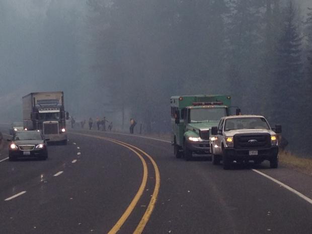
Wenatchee Complex Fire, Highway 97
Firefighters patrol a smoky section of Highway 97 on the Wenatchee Complex Fire. Photo by Jim Timaselli, USFS

Wenatchee residents endured heavy smoke

The residents of Wenatchee, Washington were exposed to extremely high levels of wildfire smoke for several weeks in September and October. The Wenatchee Complex fires, started from a storm that produced 4,000 lightning strikes, blackened over 56,000 acres.

According to the Wenatchee World:

… by Sept. 14, there were more than 1,100 micrograms of fine airborne particles per cubic meter. That’s more than eight times the level considered hazardous for human health. (For comparison’s sake, the clear-sky day of Dec. 19 averaged just 8.4 micrograms.)

Wenatchee’s smoke levels remained high for weeks, averaging 200 micrograms daily until Oct. 12 but never reaching that peak again. But in Cashmere, as smoke poured from canyon mouths and settled, 24-hour average particle counts there reached as high as 928 micrograms between Sept. 17 and 22.

Cashmere schools closed for three days while officials struggled to proof them against smoke, which had infiltrated the buildings and reached dangerous accumulations. Parents in other districts opted to remove their kids from school: Between Sept. 9 and Oct. 12, there were 3,400 more student absences in Chelan, Douglas, Kittitas and Okanogan counties than the same period in 2011.

Fire burns DNR facility in Washington

Yesterday a fire in a Department of Natural Resources maintenance facility in Forks, Washington heavily damaged a fire engine and destroyed three pickup trucks. All that was left of the structure was the four walls and a portion of the roof. Some components from the engine may be salvaged even though the roof collapsed onto the truck.

Colorado Springs to hold community wildfire meeting

In the wake of criticism following their management of the Waldo Canyon fire which destroyed 347 homes last June, the Colorado Springs Fire Department has scheduled a community meeting “to increase wildfire awareness and emergency preparedness in the community”, according to a news release from the city. In addition to encouraging their residents in high risk areas to prepare for the inevitable wildfires, the city has a lot of room for improvement in their training and preparedness.

Coulson modifies 2 helicopters for night flying

Coulson Aviation has modified two helicopters so that they can fight fires at night. More information is at FireAviation.com

Extreme fire danger in Victoria

Our friends down under in Victoria will be experiencing extreme bushfire danger in the southwest part of the state on Friday, with the danger in the rest of the state rated as severe. Temperatures will be above 40C (104F) until the middle of next week. Heat health alerts were issued by the chief health officer for the central and north central districts, taking in Melbourne, Geelong, Ballarat, Marysville and other townships.

Video of helicopter crash in ocean off Brazil coast

The four crewmembers of a fire department helicopter walked swam away from their helicopter after it crashed into the ocean off the coast of Copacabana beach in Brazil. Check out the video HERE. The crash occurred while they were attempting to rescue a stranded swimmer.

The Rio de Janeiro state fire department blamed the incident on an undetermined mechanical failure.


Thanks go out to Dick

More fire crew videos, fire season summaries

UPDATED January 1, 2013: added a video from the Wind Cave National Park fire organization.

=============
Yesterday we posted two videos that hotshot crews produced which summarized their 2012 fire season. Today we have more.

The first one is the Entiat Hotshots (based on the Okanogan-Wenatchee National Forest in Washington):

Next is the Sawtooth Hotshots (Sawtooth National Forest in Idaho):

And finally, Lakeview Helitack: (near Lakeview, Oregon)

From the fire personnel at Wind Cave National Park:

Let us know if you are aware of any other good videos summarizing the 2012 fire season.


Thanks go out to Matt

Investigators determine cause of fire in Washington that burned 61 homes

air tanker drops on Taylor Bridge fire
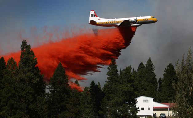
Tanker 489, a Lockheed L-188A Electra, drops on the Taylor Bridge fire August 14 at the Sunlight Waters housing development, as the fire advances on the community near Cle Elum, Washington. Photo by, and used with permission from, Joshua Trujillo / SeattlePI

Fire investigators from the Washington state Department of Natural Resources have determined that the Taylor Bridge fire was caused by a construction crew working on a bridge on Highway 10. The fire destroyed 61 homes and blackened about 23,000 acres southeast of Cle Elum. It started on August 13 about 30 feet from where one worker was cutting rebar with a STIHL power saw on the bridge deck and where a second worker was welding under the bridge.

The contractors were working on a state Transportation Department project during a period when industrial activity was supposed to be shut down because of high fire danger.

During the construction work a water truck was on site but the operator was away on an errand and no one else on site knew how to run it. Some workers connected a garden hose to the truck but the “trickle of water”, according to the report, was not effective in stopping the fire. Fire extinguishers on the project were scarce so employees used shovels to fight the fire, at least until it went over the hill.

The investigation found that there had been two other unreported fires on the project earlier that had been put out by employees.

The two companies working on the project were Conway Construction of Ridgefield and a subcontractor, Rainier Steel of Auburn.

The DNR is consulting with the Attorney General’s office about their options to recover a portion of the $11 million spent fighting the fire.

Exploding targets, an increasing wildfire problem

Star Exploding Targets, flames
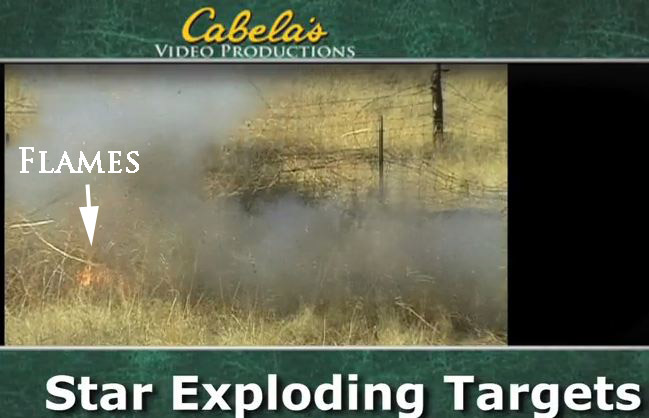
A screen grab from a video endorsed by Cabela’s demonstrating a Star Exploding Target. We added the arrow and the “Flames” text to point out that flames are visible following the explosion.

Originally published October 11, 2012, updated February 6, 2013

Targets that are designed to explode when shot with a rifle have become more popular in recent years, emerging as an increasing threat to our wildlands. The problem is, they sometimes start fires in spite of claims by the manufacturers saying they are safe.

The military has been using them for at least 20 years when training marksmen to hit targets hundreds of yards away, since it can be difficult to see if a target was hit at that distance. When struck with the bullet from a rifle, the explosion and smoke are easily seen and indicate that the shooter hit the target

They are sometimes called “binary exploding targets”, since they are completely inert until two powders are mixed at the site by the target shooter. After they are combined, the compound is illegal to transport. The manufacturers claim that the only way they can be detonated is by striking them with a high-velocity bullet fired from a high-powered center-fire rifle. At least one company has recently started offering targets that will explode when hit with a much less powerful .22 caliber rim-fire rifle.

While the manufacturers claim they can’t start a fire, the screen grab (above) from a video shows flames in the grass just after a target advertised by Cabela’s and manufactured by Star Exploding Targets, explodes. The video is below, however we expect that eventually Cabela’s and Star will remove it from YouTube. The flames are visible three seconds into the video at the bottom left.

In a quick search, we found numerous reports of wildfires having been caused by exploding targets in a 5-month period. The dates below indicate when the information was published.

  • June 17, 2012, Colorado. The Springer Fire in Park County on the Pike National Forest burned 1,045 acres. It was caused by exploding targets.
  • June 13, 2012, Idaho. Four wildfires were caused by shooters using exploding targets up to that date in 2012.
  • June 15, 2012, Washington. A small fire near the mouth of the Grande Ronde River was apparently started by someone shooting at exploding targets.
  • June 16, 2012, Utah. The 300-acre Little Cove fire was caused by shooters using exploding targets.
  • June 29, 2012, Utah. A fire investigator said eight wildfires in the previous three weeks were caused by shooters using exploding targets.
  • July 2, 2012, Nevada. A five-acre fire in Elko was caused by shooters using exploding targets.
  • August 19, 2012, Oregon. Five shooters were cited for starting a 35-acre fire using Tannerite exploding targets.
  • September 6, 2012, Washington. The Goat Fire burned 7,378 acres 3 miles southwest of Pateros, WA. It was started by exploding targets. Forest Service officials previously said two smaller fires — a 120-acre blaze in Mud Creek Entiat and one on Deadman Hill near Cashmere — may also have been ignited by exploding targets.
  • October 7, 2012, Pennsylvania. Two state Game Commission workers suffered injuries including burns, temporary blindness and hearing damage when an illegal exploding target blew up while the men attempted to put out a fire at a gun range in Pike County.
  • October 11, 2012, California. A 364-acre fire was started by shooters using exploding targets. A news report (see video below) shows two pounds of the explosive being used to blow up a car.
  • October 19, 2012, Utah. Two men have been charged with starting the Dump fire near Saratoga Springs, Utah that burned more than 5,500 acres and cost $2.1 million to put out. About 2,500 people were forced to evacuate. Investigators say the men were shooting June 21 when they hit an explosive target that started the fire in vegetation.
  • October 23, 2012, Nebraska. Three men have been charged with starting a fire by using exploding targets in Nebraska, and starting the Spotted Tail fire that burned 83 acres south of Chadron October 23.

This is a total of 24 fires that were either confirmed or suspected to be caused by exploding targets since the first of June, 2012. And these are just the ones that we were able to find using Google.

In most areas in the western United States exploding targets are illegal to use if there is a law or temporary ban on open fires.

One of the primary manufacturers of the targets is Tannerite. The company has a patent on the devices and has said the fires are caused by other companies infringing on their patent and adding an additional incendiary component in order to produce a more spectacular explosion.

At an online forum for firearms enthusiasts, The Firing Line, some of the posters decry the lack of wisdom of target shooters who start fires with exploding targets. A person using the moniker “g.willikers” wrote:

It seems that we gun owners have two enemies. Those who would deprive us of our gun rights. And those who throw those rights away.

Others on the forum suggested some alternative targets that can produce an impressive display when hit with a bullet, such as:

  • A milk jug filled with water
  • Potatoes
  • Pop can filled with water
  • Fresh cow pie

UPDATE October 12, 2012:

Ken told us about this news report that appeared on television in southern California October 11, 2012, explaining and demonstrating the hazards of these explosive targets. They use two pounds of the explosive to blow up a car, and Chief John Hawkins of CAL FIRE provides his point of view on the problem.

Table Mountain Complex triples in size

Central Washington Fire,
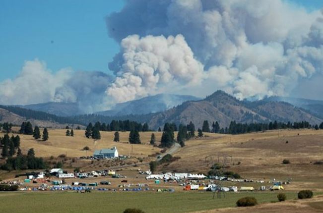
One of the fires in central Washington. Photo by Kittitas Fire District

The Table Mountain Complex of fires tripled in size Wednesday and Wednesday night, growing from 9,500 acres to 30,434 acres, according to Bob Redling, an Information Officer for the fire which is burning in central Washington 11 miles east of Cle Elum. Usually firefighters can expect the relative humidity (RH) to increase substantially at night, slowing the spread of a fire significantly. However, the RH recorded at the Dry Creek weather station 26 miles north of the fire measured a low of 9 percent Wednesday afternoon that only went up to a high of 29 percent early Thursday morning. Even though the winds were moderate and in the single digits, the fire still added over 20,000 acres.

There are unconfirmed reports that on Wednesday the convection column of smoke went up to over 40,000 feet and carried 8-inch pieces of burning bark 6 to 7 miles away, falling near the Mission Ridge Ski Area.

Around 161 residences have been evacuated and at least one cabin has been destroyed by the fire.

Fire and windmills
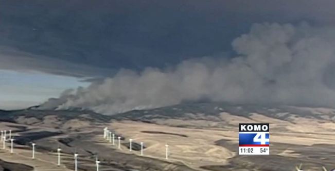
KOMO photo

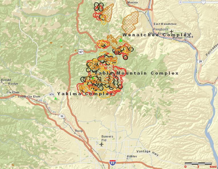
There are four large fires in the complex and firefighters are now managing them as one, since they expect them all to burn together soon. As you can see in the map below, the Table Mountain Complex of fires is very close to the Yakima Complex to the south and the Wenatchee Complex to the north.

Map of Table Mountain, Yakima, and Wenatchee fires
Map of Table Mountain, Yakima, and Wenatchee fires, 10:33 a.m. MT September 20, 2012. The red and yellow areas are the most recently burned. (click to enlarge)

Most of these fires started from a major lightning storm on September 8 when over 3,000 strikes were recorded. There are approximately 95 fires in the Yakima Complex, according to information on Inciweb. 

The video below has more information about the fires in the area.


Taylor Bridge fire burns 60 homes in Washington

air tanker drops on Taylor Bridge fire
Tanker 489, a Lockheed L-188A Electra, drops on the Taylor Bridge fire on Tuesday at the Sunlight Waters housing development, as the fire advances on the community near Cle Elum, Washington. Photo by, and used with permission from, Joshua Trujillo / SeattlePI

The Taylor Bridge fire has burned approximately 60 homes 4 miles southeast of Cle Elum and 4 miles northwest of Ellensburg, Washington. Several communities are under evacuation orders.

The fire has blackened 28,000 acres of grassland, sage brush, and timber and is 10 percent contained.

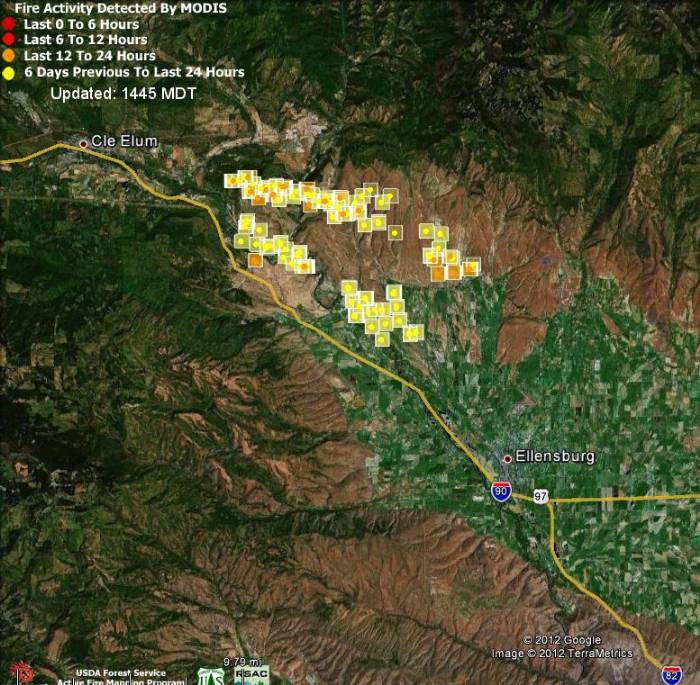
Map, Taylor Ridge fire, August 15, 2012
Map showing heat detected by a satellite on the Taylor Bridge fire, 1:13 p.m. PT, August 15, 2012. MODIS-Google (click to enlarge)

The map of the Taylor Bridge fire above shows that the fire was producing few large sources of heat that could be picked up by the satellite when it passed over the area at 1:13 p.m. PT on Wednesday.

On Wednesday firefighters are focusing on the Sun Light Waters area on the southwest side of the fire, as well as the northern perimeter in the Hidden Valley area.