Wildfire potential for August through November

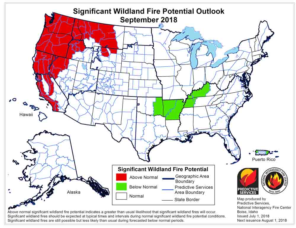
Above: Wildfire potential for August, 2018. NIFC.

(Originally published at 1:20 p.m. MDT August 1, 2018)

On August 1 the Predictive Services section at the National Interagency Fire Center issued their Wildland Fire Potential Outlook for August through November. The data represents the cumulative forecasts of the ten Geographic Area Predictive Services Units and the National Predictive Services Unit.

If their analysis is correct, in August and September firefighters will be busy in Washington, Oregon, Idaho, California, and northern Nevada.

Below are:

  • An excerpt from the NIFC narrative report for the next several months;
  • NIFC’s monthly graphical outlooks;
  • NOAA’s three-month temperature and precipitation forecasts; and,
  • Drought Monitor.

“August is the peak month for fire activity across the West. Given the amount of lightning received along with preexisting heavy fuel loading and dryness, a very active month is expected with Above Normal significant wildland fire potential likely across portions of the Pacific Northwest, Northern Rockies, northern Great Basin, and California. Typically, a weather event occurs by mid-September that brings moisture to regions experiencing significant fire activity which allows for the western fire season to begin to decrease in activity. Given ongoing trends that support a normal seasonal progression and given a transition from ENSO Neutral conditions to El Niño, such an event is expected. Most regions will exit the fire season at this point, but only a brief lull is expected across California before it enters its fall fire season by October and November. Given ongoing dryness in the fuels, the fall season may very well be robust across portions of the state.”

September 2018 wildfire potential

Continue reading “Wildfire potential for August through November”

Calm before the storm?

Posted on Categories UncategorizedTags

 Above: Estimated precipitation July 4 to July 11, 2018. Intellicast

We have entered a relatively quiet period of wildfire activity in the western United States. On today’s national Situation Report, more fires decreased in size than increased. Of the fires that had changes of more than 100 acres, only three got larger, while five actually decreased. The reported size getting smaller is a result of more accurate mapping.

The seasonal monsoonal flow has been bringing precipitation to not only the Southwest, but it has been pushing north into parts of Nevada, Utah, and Colorado. And the typical July thunderstorms have been affecting other areas as well.

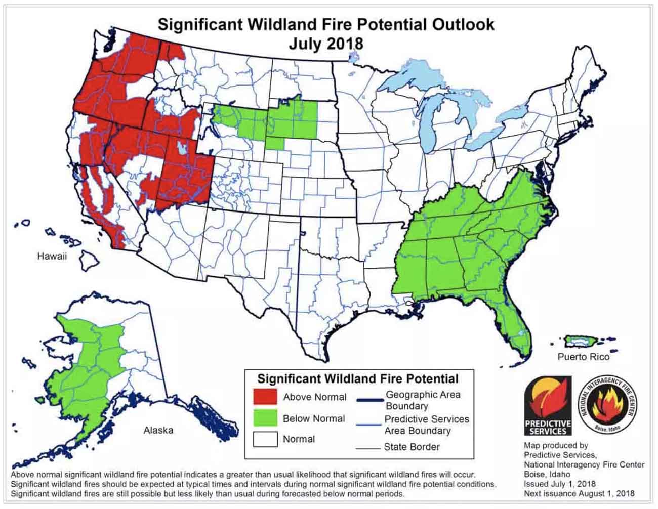
wildfire potential july 2018

As a reminder, the National Interagency Fire Center predicted July 1 that fire activity would increase this month in parts of California, Nevada, Utah, Washington, Oregon and Idaho. California has had some large fires, Utah has had several, and the Martin Fire in Northern Nevada has burned almost 440,000 acres. We’ll see what happens during the second half of the month.

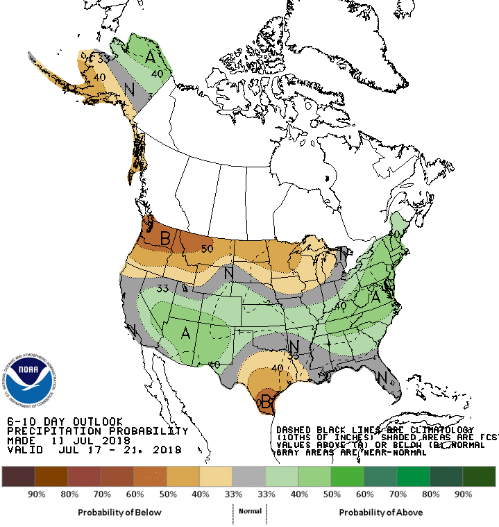
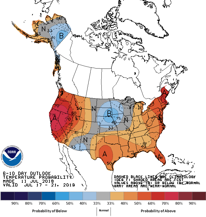
The updated precipitation and temperature outlooks for the next six to ten days predict higher than normal temperatures in the far west and dry conditions in the Northwest and Northern Rockies.

precipitation outlook temperature outlook

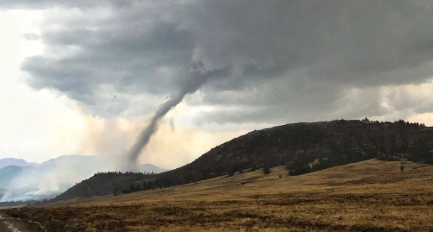
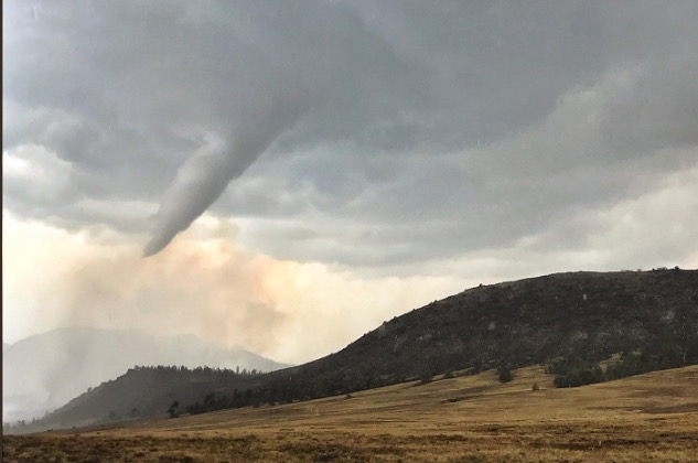
Tornado observed near Weston Pass fire in Colorado

Tornado Weston Pass Fire
Tornado near the Weston Pass Fire. Photo by Wellington Fire Department, @WellingtonFire1.

Wildland firefighters have enough to worry about,  but Thursday a tornado briefly touched down just south of the Weston Pass Fire, then while receding back into the cloud it moved directly over the fire.

Tornadoes are very rare in this part of the country. According to the National Weather Service office in Boulder, it was the 6th confirmed tornado in Park County since records began in 1950.

Chief Meteorologist/Climatologist for 11 News in Colorado Springs, said “No, this isn’t a firewhirl, it is a legit tornado produced by a thunderstorm that moved across the Weston Pass Fire.”

The Weston Pass Fire has burned about 13,000 acres 9 miles southwest of Fairplay, Colorado.

Tornado Weston Pass Fire
Tornado near the Weston Pass Fire. Photo by Wellington Fire Department, @WellingtonFire1.

Thanks and a tip of the hat go out to Jason.
Typos or errors, report them HERE.

Wildfire potential increases in California and the Northwest

(Originally published at 11:55 a.m. MDT July 2, 2018)

On July 1 the Predictive Services section at the National Interagency Fire Center issued their Wildland Fire Potential Outlook for July through October. The data represents the cumulative forecasts of the ten Geographic Area Predictive Services Units and the National Predictive Services Unit.

If their analysis is correct, in July the areas with the highest potential will move from the Southwest to Washington, Oregon, Idaho, Utah, California, and northern Nevada.

Below are:

  • The highlights of the NIFC narrative report for the next several months;
  • NIFC’s monthly graphical outlooks;
  • NOAA’s three-month temperature and precipitation forecasts; and,
  • Drought Monitor.

“Abnormally dry conditions along the West Coast allowed for a northward expansion of drought into western Oregon and Washington in June. Some improvement was noted across the southern Great Plains while drought emergence was observed across the Lower Mississippi River Valley. Preexisting drought conditions and continued drier than average conditions across the Southwest allowed for a normal progression of the fire season across the Four Corners Region until mid-month when the remnants of Hurricane Bud moved north from Mexico and produced widespread wetting rainfall that reduced the elevated large fire potential in that area. While rainfall amounts that were greater than 200% of average were received across Arizona, New Mexico, and portions of southwestern Colorado, the Great Basin and California remained very dry receiving less than 10% of average precipitation. Temperatures across the West were near average for the month from the Pacific Coast east to the Continental Divide. East of the Divide, temperatures were near average.

“The southwestern monsoon is expected to arrive in early July and should reduce fire activity across the Southwest. A normal refocusing of fire activity north into the Great Basin and west into California is expected. The existence of a continuous grass from this year along with carryover of fine fuels from 2017 should lead to Above Normal Significant Large Fire Potential in these areas. By late July, fire activity is expected to increase across Oregon and Washington. Entry into the Western Fire Season will be delayed slightly across most of the Northern Rockies due to the persistent wet systems that impacted the region through… However, precipitation data shows an area of below average precipitation for June across extreme northwestern Montana and northern Idaho. As a result, both areas could experience an early entry into the fire. In Alaska, the fire season will gradually come to an end in July as precipitation events become more frequent.

“August is the peak of the Western fire season. Seasonal transitions focus the fire activity over the northwestern quarter of the country, though California also continues to experience significant activity. With significant carryover of fine fuels from last year and an average grass crop growth this year, elevated fire potential is expected August through early September in this region from California and the Central Great Basin north to the Canadian Border. Higher elevations in the mountains may also see elevated fire potential as well should warmer and drier than average conditions develop as expected.

Continue reading “Wildfire potential increases in California and the Northwest”

Elevated fire danger in the Southwest today

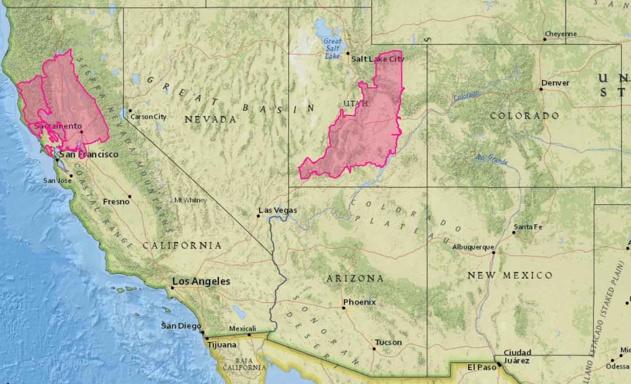
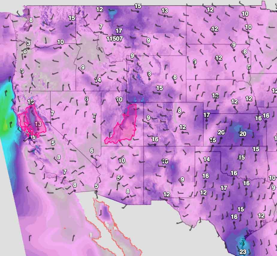
Above: map showing minimum relative humidity levels predicted for Saturday in the Western United States. Red Flag Warning areas are in Utah and Northern California. NWS.

The official Red Flag Warnings for Saturday only include portions of Utah and Northern California, but low humidities will be prevalent across most of the southwest one-quarter of the country. Generally, the winds will not be especially strong, which is probably what kept the Red Flag Warning areas from being larger than they are.

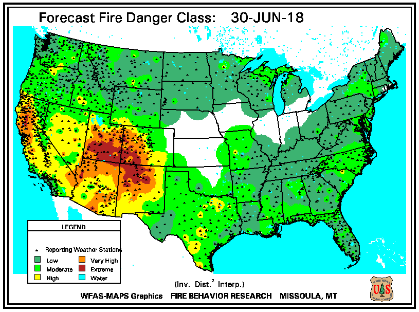
Very high to extreme fire danger levels are predicted for large portions of Utah, Colorado, Arizona, and New Mexico, as well as the lower elevations in Northern California.

Predicted fire danger for Saturday
Predicted fire danger for Saturday.
Fire Weather Outlook
Predicted Fire Weather Outlook for Saturday. NWS.
Red Flag Warnings for Saturday
Red Flag Warnings for Saturday.
Sustained wind speeds predicted
Sustained wind speeds predicted for 3 p.m. Saturday. NWS.

Weather slows fire activity in Western United States

Above: Accumulated precipitation over the last seven days, June 12-18, 2018. 

Moderating weather over the last seven days has helped firefighters make progress on some of the fires in Colorado, Wyoming, New Mexico, and Utah. Today’s national Situation Report showed little or no increase in the size of wildfires in those four states. The 416 Fire in southwest Colorado and the Badger Creek Fire in southern Wyoming released a total of 345 personnel over the last 24 hours.

Todd Pechota’s Type 1 Incident Management Team is currently assigned to the 416 Fire, but Joe Reinarz’s NIMO team has been mobilized for the fire, which could be an indication that they expect it to be a long term incident. The west side of the fire has spread into steep, remote terrain above 8,000 feet as it grows closer to an 11,000 to 12,000-foot ridge five miles away. Much of the ridge is above the timber line and may eventually, with patience over time, serve as a barrier. Mr. Reinarz’s team team will transition on Friday.

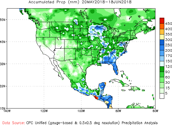
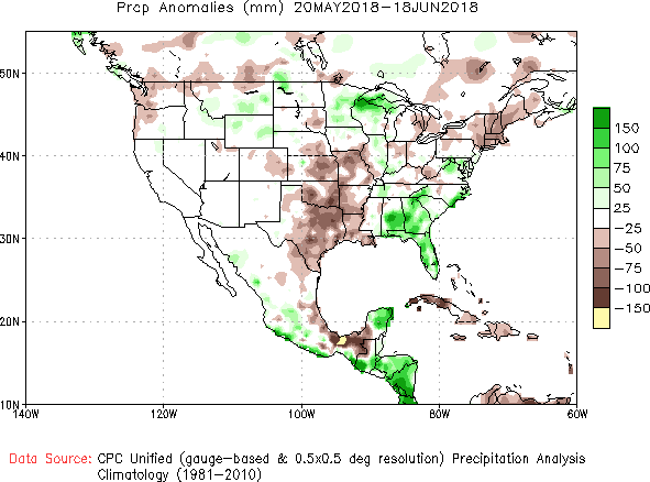
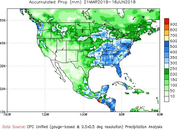
Below, National Weather Service graphics show the observed precipitation and the departure from normal for the last 30 and 90 days.

precipitation 30 days
Accumulated precipitation, May 20 through June 18, 2018. NWS.
precipitation 30 days
Precipitation departure from average, May 20 through June 18, 2018. NWS.
precipitation 90 days
Accumulated precipitation March 21 through June 18, 2018. NWS.
precipitation 90 days
Precipitation departure from average, March 21 through June 18, 2018. NWS.