
Above: map showing the distribution of smoke from wildfires in the United States and Canada. Created by NOAA at 9:31 p.m. MDT September 14, 2017.
Maybe the rain expected in the Northern Rockies Friday and Saturday will clear out some of the smoke.

News and opinion about wildland fire

Above: map showing the distribution of smoke from wildfires in the United States and Canada. Created by NOAA at 9:31 p.m. MDT September 14, 2017.
Maybe the rain expected in the Northern Rockies Friday and Saturday will clear out some of the smoke.
Today there are 71 large uncontained wildfires in the United States.
Above: the red and orange dots on the map represent heat on wildfires detected by a satellite in the 24 hours before 7:30 a.m. MDT September 11, 2017. Heat found before that is not shown.
(Originally published at 7:45 a.m. MDT September 11, 2017)
In spite of the hurricanes impacting the southeast United States, the wildfires in the Cascade Range and the Northern Rockies persevere in Montana, Idaho, Oregon, Washington, and Northern California.
Off and on over the last week they have slowed as clouds and even some scattered very light showers passed over the areas, but the National Interagency Fire Center reported today there are 71 active large fires, 32 that are being suppressed and 39 that are being suppressed only where needed to protect property.
So far this year 8.2 million acres have burned in the United States, which is 46 percent higher than the 5.6 million average to this date.

The weather for Monday and Tuesday could be conducive to fire growth, especially in Northwest Montana where a Red Flag Warning is in effect Monday. But Wednesday through Saturday will bring a chance of rain to Idaho and Western Montana, while the forecast for Northern California, Oregon, and Washington looks dry this week.

The prediction for October shows enhanced fire potential for the Northern Rockies and much of western California.
On September 1 the Predictive Services section at the National Interagency Fire Center issued their Wildland Fire Potential Outlook for September through December. The data represents the cumulative forecasts of the ten Geographic Area Predictive Services Units and the National Predictive Services Unit.
Below are:
****
“The Western fire season is reaching its peak for 2017 as it enters September. While an active southwestern monsoon has curtailed activity in the Southwest and across portions of the central Rockies, above normal significant fire activity continues to be observed across portions of the Pacific Northwest, Northern Rockies, northern Great Basin and northern California. Fuel moisture levels and fire danger indices in these areas are at near-record to record levels for severity. While the frequency and density of lightning occurrence has begun its seasonal decline, occasional lightning bursts are still being observed. Most of the new lightning-caused fire starts are being effectively handled with initial attack, but a few are still developing into larger incidents that require additional resources. Drier and warmer than average conditions across the central Great Basin and Southern California are allowing for the fine fuels to become more receptive to fire activity. A slight upturn in initial attack activity is being observed in both areas. Cool and wet conditions have arrived in Alaska. Its season has effectively ended.
Precipitation received was generally well below average across the Pacific Northwest, Northern Rockies, Great Basin and California in August as most areas received less than 25 percent of normal rainfall. Once exception to this was the Sierra Mountains in California where several episodes of wet convection produced rainfall amounts that were above average. Across the central Rockies and the Southwest, precipitation amounts were near average. Temperature extremes were less frequent in August than in July. For the month, average temperatures were only a few degrees above average.
Fire season will peak by mid-September as the fuels remain much drier than average and as existing precipitation trends continue. By mid-September decreasing solar radiation received and longer nights will allow for fuel moistures to begin recovering. Should a season-slowing weather event not occur, this will be sufficient to allow for the fire activity across the northwestern states to begin to decrease significantly late in the month. Significant large fire activity will remain possible in foehn wind-prone areas like the Rocky Mountain Front and across Southern California through November and will be event-driven should they occur.”


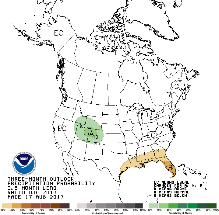
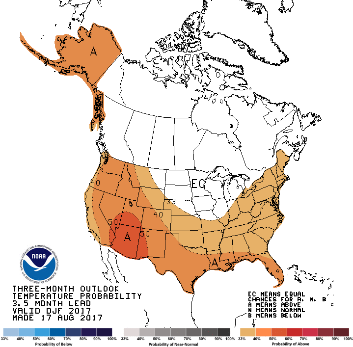


Weather forecasters just released their three-month outlook for September through November in the United States. If correct, it will be warmer than normal across the entire country and the precipitation will be close to average except in the Southeast where they expect wetter conditions. This could lead to extended Autumn wildfire seasons.

The prediction for August shows enhanced fire potential for the Northern Rockies, Northern Nevada, and much of California and the Northwest.
On August 1 the Predictive Services section at the National Interagency Fire Center issued their Wildland Fire Potential Outlook for August through November. The data represents the cumulative forecasts of the ten Geographic Area Predictive Services Units and the National Predictive Services Unit.
It revises the outlook that was issued for August a month ago, adding to the “Above Normal” category Northern Idaho, the eastern halves of Oregon and Washington, and Western Montana. Many of the August “Above Normal” areas will carry over into September except for the areas in Oregon and Washington.
Below are:
****
The seasonal transition of the western fire season north has occurred. A strong southwestern monsoon has developed over the Southwest and has reduced the significant large fire potential and activity across the Four Corners Region. Significant lightning activity associated with the monsoon has spread north creating numerous incidents across the northern Great Basin, Northern California, Pacific Northwest, and the Northern Rockies. With the fine fuels now fully cured and with larger fuels now receptive, even at the higher elevations, fire activity is increasing as it nears its seasonal peak in August. While the northwestern states have shown a significant upturn in activity, fire activity in Alaska has begun to wane with the arrival of the late summer rains across the Alaskan Interior. The eastern and southeastern states have seen and will continue to experience overall limited activity as the regions remain largely out of season.
Precipitation received was generally well below average across the western half of the country in July. With the occurrence of three significant heat wave events, fuels dried quickly and became receptive to fire earlier than in most years. By month’s end, the previous winter’s record snowpack and above average spring rainfall was a distant memory. Drought was beginning to reemerge in the Rockies and across portions of the Pacific Northwest. Across the northern Great Plains, the established long term drought conditions continued to worsen. Large fire activity became problematic across eastern Montana, Wyoming and the Dakotas.
Looking forward to the peak of the western fire season in August and September, conditions are expected to remain favorable for the Above Normal significant fire activity to continue. Areas with the greatest potential for significant large fire activity will be the grasses and rangelands of the Pacific Northwest east of the Cascades, the lower and middle elevations across California, most of the Northern Rockies region. The grass and rangelands across the northern Great Basin will also continue to demonstrate Above Normal significant large fire potential and activity.
****


****

****

(Updated at 8 a.m. MDT July 31, 2017)

Above: excessive heat warnings. Below: Red Flag Warnings and Fire Weather Watches. All were updated at 7:50 a.m. MDT July 31, 2017.

Firefighters: be careful out there. It’s a good time to review how to prevent and deal with heat related illnesses. Drinking water is important, but it will not prevent heat exhaustion, heat stroke, or rhabdo. And those last two can kill.


