Wildland fire potential, July through October

On July 1 the Predictive Services section at the National Interagency Fire Center issued their Wildland Fire Potential Outlook for July through October, 2016. The data represents the cumulative forecasts of the ten Geographic Area Predictive Services Units and the National Predictive Services Unit. Below are highlights from the outlook.

****

“During late June and July significant wildland fire potential usually transitions from the Southwest and southern California northward into the remainder of the western United States. The timing of this transition should be near normal; however, some areas will experience an increased potential for significant fires due in large part to high fine fuel loading. These areas include the northern and western Great Basin, northern California and some of the finer fuel regime areas of Montana, Wyoming and the Dakotas. Additionally the Southwest will continue to see elevated significant wildland fire potential through July as monsoonal rainfall may not be as consistent as usual. Southern California also will continue to have elevated significant fire potential throughout the period driven by long term drought and vegetation mortality. Alaska fire potential will remain near normal with the northern portions of the state below normal. Alaska usually begins to transition to late season conditions in July and August.

wildfire potential August 2016

The same heavy fine fuel crops that are driving the above normal forecast for July will continue to present above normal potential into August. Forecasted normal conditions in the higher elevations for August, however, mean that a number of significant wildland fires are likely to develop in these areas throughout the West. Fire season in the western U.S. is typically at its peak in July and August and this year should be no different with the potential for significant fires across the spectrum of fuel regimes all indicating at least normal levels of fire activity.

wildfire potential Sept and Oct 2016

In September and October the northern tier of states should see a rapid return to normal wildfire potential. The focus for activity should transition to California. Long term drought is expected to remain in place and fall conditions typically bring an increase in offshore wind events that often drive fire activity for the state.”

Wildfire potential, June through September

On June 1 the Predictive Services section at the National Interagency Fire Center issued their Wildland Fire Potential Outlook for June through September, 2016. The data represents the cumulative forecasts of the ten Geographic Area Predictive Services Units and the National Predictive Services Unit.

If their forecast is correct, Alaska, the Northwest, the East, the Central states, and Rocky Mountain areas will avoid unusually high wildfire activity. Over the four-month period above normal wildfire potential should move from Arizona and New Mexico into California, Nevada, and southwest Idaho, and remain high in Hawaii for the entire period.

Wildfire Potential July 2016 Wildfire Potential Aug-Sep 2016

Here are the highlights of the written report issued May 1 (which we have reformatted a little for easier reading). More details are available at the link above.

****

Eastern States

“Conditions across the Eastern States have mitigated enough thanks to timely moisture and the onset of green-up that these areas no longer present a concern for above normal significant wildland fire potential.

Alaska

For June and early July two primary areas of fire activity are the focus. First, Alaska has begun to see significant fire activity. Recent moisture over the state has dried out, triggering an increase in fire activity. Some of these fires are holdover fires from the 2015 fire season. Alaska will continue to see normal levels of significant fire activity into July.

Southwest Area

Second, the Southwest Area enters its primary fire season in June and July. This area has a robust fine fuel crop; however, lingering moisture has largely kept significant fires at bay. As seasonal drying progresses south of the Mogollon Rim, expect above normal levels of significant fire potential to remain dominant through at least early July, especially in fine fuel regimes.

Great Basin and California

Heavy and continuous fine fuel loadings are expected across the Great Basin and lower elevation areas of southern and central California. Dry and windy periods will increase fire activity and the potential for fires to become large and grow rapidly. Fire activity will begin in June and July and transition northward throughout the Outlook period. Warm conditions have depleted much of the mountain snowpack. Remaining snowpack should continue to melt off but remain long enough for a normal to slightly delayed onset of higher elevation fire activity. Nearly all higher elevation timbered areas are expected to see normal fire activity throughout the Outlook period.

Other areas

Most other areas of the U.S. are expected to see normal significant fire potential throughout the summer fire season. It is important to note that normal fire activity still represents a number of significant fires occurring and acres burned.”


As a bonus, here is some additional weather data:

Continue reading “Wildfire potential, June through September”

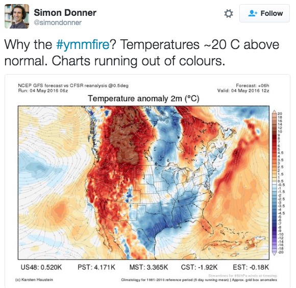
Tuesday’s weather in Fort McMurray was 8 degrees above record high for the date

Hot weather Alberta

“#ymmfire” refers to the airport code for the Fort McMurray International Airport in Alberta. The entire population of the city, more than 80,000, was ordered to evacuate when it became obvious it was going to be overrun by the fire.

More information about the fire.

Below is an excerpt from a May 4, 2016 article at Slate about the weather in Canada:

…Canada’s northern forests have been burning more frequently over recent decades as temperatures there are rising at twice the rate of the global average. A 2013 analysis showed that the boreal forests of Alaska and northern Canada are now burning at a rate unseen in at least the past 10,000 years. The extreme weather of recent months is also closely linked with the ongoing record-setting El Niño conditions in the Pacific Ocean, which tends to bring a warmer and drier winter to this part of Canada. Last month, Canadian officials mentioned the possibility of “large fires” after over-winter snowpack was 60 to 85 percent below normal and drought conditions worsened.

This week, a strong atmospheric blocking pattern—a semi-stable extreme arrangement of the jet stream—reinforced an unseasonable heat wave and helped temperatures reach 90 degrees Fahrenheit (32.2 degrees Celsius) on Tuesday in Fort McMurray, 40 degrees Fahrenheit above normal, eight degrees above the daily record high, 15 degrees warmer than Houston, and the same temperature as Miami. While fleeing, some evacuees had to turn on their air conditioners…

Wildfire potential, May through August

On May 1 the Predictive Services section at the National Interagency Fire Center issued their Wildland Fire Potential Outlook for May through August, 2016. The data represents the cumulative forecasts of the ten Geographic Area Predictive Services Units and the National Predictive Services Unit.

If their forecast is correct, the Northwest and Rocky Mountain areas will avoid unusually high wildfire activity while Hawaii and some locations in the Southwest, California, Nevada and southern Idaho could be busy in June, July, and August.

UPDATE May 2, 2016. NIFC took the unusual step of producing a video version of the outlook. It was released today.

Here are the highlights of the written report issued May 1. Following that are maps for June through August.

****

“Conditions in the mid-Atlantic and Appalachian region were dry enough through April to see increased fire activity at the end of the month. Greenup and increases in precipitation will decrease much potential through May.

“Heavy fine fuel loadings are expected across the Southwest and Great Basin, and lower elevation areas of southern and central California. This will likely increase fire activity in these areas throughout fire season especially when associated with dry and windy periods.  Fire activity will begin in May and June across the Southwest and transition northward as usual throughout the June and July.

“Warm April conditions depleted some of the mountain snowpack. Remaining snowpack should continue to melt off but remain long enough for a normal to slightly delayed onset of higher elevation fire activity. Nearly all higher elevation timbered areas are expected to see normal fire activity throughout the Outlook period.

“Poor seasonal snowpack and early snowmelt in South Central Alaska will likely to lead to above normal conditions in May, especially in the populated corridors.

“Significant moisture across the Central U.S. is expected to produce below normal significant fire potential, especially coupled with green-up occurring throughout this area.

“Most other areas of the U.S. are expected to see normal significant fire potential throughout the summer fire season. It is important to note that normal fire activity still represents a number of significant fires occurring and acres burned.”

Outlook-June

Outlook_July-Aug

Wind map, April 5, 2016

The image above is a screen grab from an animated graphic showing the wind speed and direction in the United States at 1:35 p.m MDT today. This image does not do it justice. Go to the Wind Map site and become mesmerized by the animation.

The map gives us a clue that firefighters working on the fire in Woodward County in northwest Oklahoma might be challenged to keep up with it.

Wildfire potential for April through July

On April 1 the Predictive Services section at the National Interagency Fire Center issued their Wildland Fire Potential Outlook for April through July, 2016. The data represents the cumulative forecasts of the ten Geographic Area Predictive Services Units and the National Predictive Services Unit.

If their predictions are correct, elevated wildfire potential will be migrating toward the southwest during the four-month period, while it is expected to remain above normal in Hawaii through July.

Here are the highlights from their outlook. Click on the images to see larger versions.

April
wildfire potential April 2016

  • Above normal significant fire potential continues across the southern Plains to the Upper Midwest; the mountains of Virginia and North Carolina; the Hawaiian Islands; and will develop in south central Alaska.
  • Below normal significant fire potential will remain across the central Gulf Coast and Puerto Rico.
  • Significant fire potential is normal across the remainder of the U.S., though the potential for pre-greenup fire activity increases through early spring.

May
wildfire potential May 2016

  • Above normal significant fire potential will return to normal across the southern Plains through the Upper Midwest.
  • Above normal potential will develop in the fine fuel areas of the southern Southwest. Above normal fire potential will continue across the Hawaiian Islands and south central Alaska.
  • Below normal significant fire potential will continue across the central Gulf Coast, central Georgia, upstate South Carolina, and eastern Puerto Rico.
  • Significant fire potential will remain normal across the remainder of the U.S.

June and July
wildfire potential June-July 2016

  • Above normal significant fire potential will continue across the southern Southwest and expand into Texas and southern Nevada. Above normal potential will also develop in northwestern Nevada and northeastern California as well as the fine fuel areas of southern California. An area of above normal potential will develop in Florida.
  • Significant fire potential will remain normal across the remainder of the U.S.

=================

A bonus: the drought monitor, temperature/precipitation outlooks, and the southern California outlook.

Continue reading “Wildfire potential for April through July”