Chimney Fire spreads into Monterey County

CAL FIRE estimates 48 structures have been destroyed

(UPDATED at 11:45 a.m. PDT August 22, 2016)

(An updated article about the Chimney Fire was published August 24, 2016)

The Chimney Fire 7 miles north of Cambria near the central California coast was very active Sunday on the north and northwest sides where it spread 2.5 miles further north in about 24 hours. The fire is well established north of the western arm of Lake Nacimiento. It expanded by over 7,000 acres, growing to 31,664 acres.
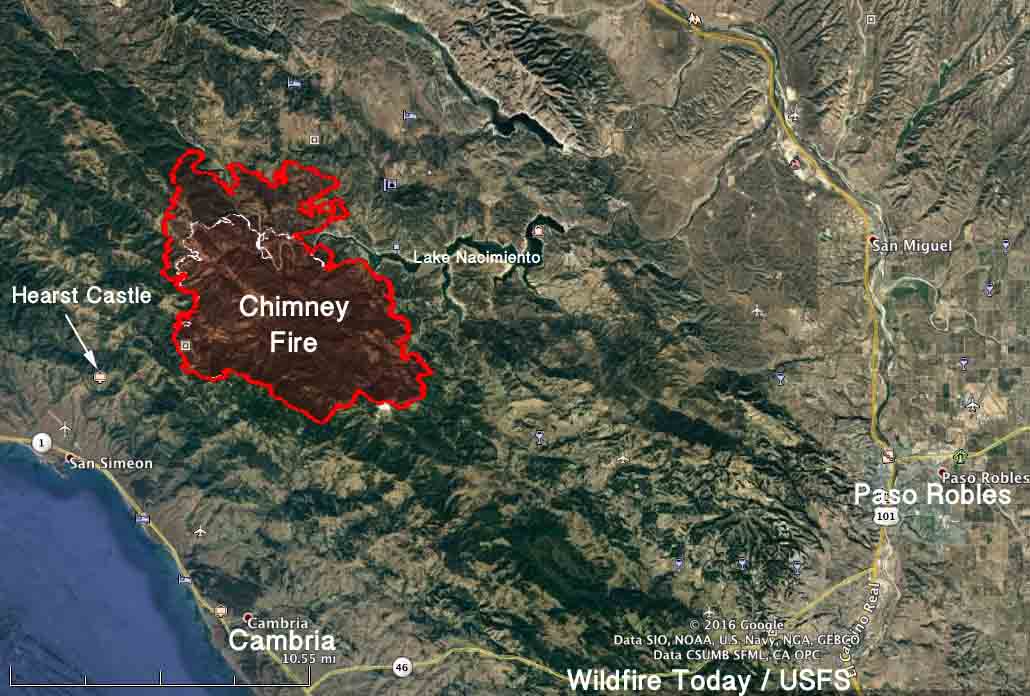
Map of the Chimney Fire
Map of the Chimney Fire. The red line was the perimeter at 9 p.m. PDT August 21, 2016. The white line was the perimeter about 24 hours before.

There has been no update from CAL FIRE about the number of structures destroyed since they reported that 48 have burned and another 7 have been damaged.

Late in the day and Sunday night the fire behavior was extreme and continued to challenge the control lines. It is currently burning through the Rock Butte area and has crossed into Monterey County. After the Monday morning inversion dissipates, south and southwest winds will increase to 10 mph with gusts around 20. Snags continue to be a safety hazard for firefighters.

Evacuation orders are in place for Christmas Cove, Oak Shores, Lake San Antonio, and Bryson Hesperia affecting 2,448 people.

****

Since the Chimney Fire started on August 13 it has burned 24,096 acres 5 miles from the central coast of central California, an increase of about 8,000 acres over the previous 24 hours. It is 7 miles north of Cambria and 3 miles east of Hearst Castle, a historical landmark built in the first half of the last century by newspaper magnate William Randolph Hearst.

CAL FIRE estimates that 48 structures have burned and another 7 have been damaged. Evacuations have been ordered for some locations in San Luis Obispo and Monterey Counties.

The fire has jumped across the western arm of Lake Nacimiento.
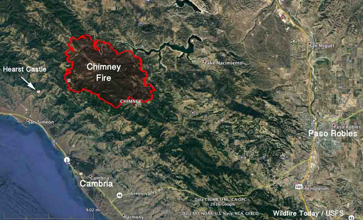
Map Chimney Fire
Map of the Chimney Fire at 2:40 a.m. PDT Aug 21, 2016. Click to enlarge.

The spread of the fire was described as extreme on Saturday and Saturday evening. Drought-stressed timber, chaparral, and grass continue to challenge firefighters in the steep inaccessible terrain as the fire continues to move north and west.
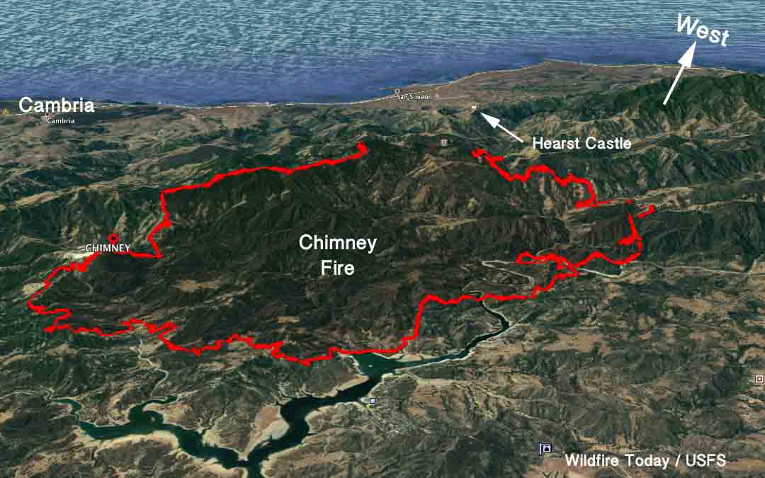
Map Chimney Fire
3-D Map of the Chimney Fire at 2:40 a.m. PDT Aug 21, 2016.

The fire is being fought by 2,699 firefighters, 218 engines, 71 hand crews, 7 air tankers, 14 helicopters, 50 dozers, and 35 water tenders.

It is unusual to have CHAIRS and a pre-built stage for an operational period briefing.

Rey Fire continues to spread to the east

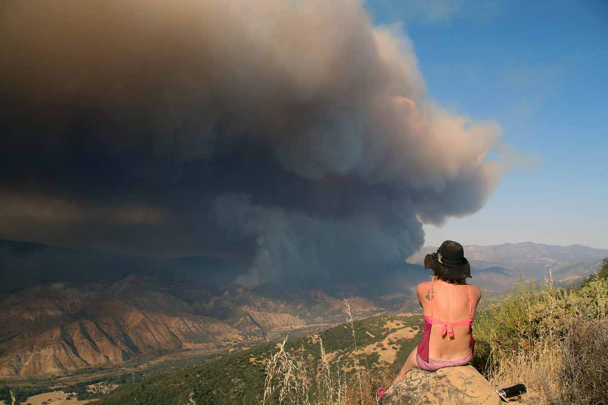
Above: The Rey Fire. Photo by Jeff Zimmerman.

(We published an updated article about the Rey Fire August 24, 2016)

(UPDATED at 8:22 a.m. August 22, 2016)

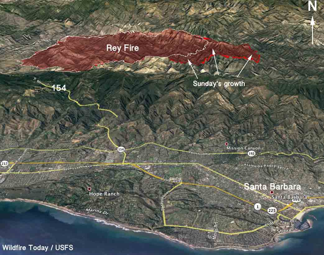
The Rey Fire continued to spread to the east on Sunday, growing by more than 4,000 acres to a total of 23,546. Almost all of the growth was on the east side where it spread for more than 2 miles but it was also active on the northeast perimeter.

3-D Map of the Rey Fire
3-D Map of the Rey Fire. The red line was the perimeter at 10 p.m. PDT Aug 21, 2016. The white line was from about 24 hours before.

The weather conditions at the fire area should be rather mild Monday, for southern California anyway. The temperature will be in the mid-80s under a mostly clear sky and the relative humidity will bottom out in the mid-20s, but the wind could be a concern. It will increase in the afternoon to 10 to 13 mph out of the northwest gusting at 16-20.

The fire is being fought by 1,260 personnel, 28 crews, 48 engines, and 2 helicopters. There are no reports of any structures that burned.

Rey Fire.
Rey Fire. Photo by Jeff Zimmerman.

The time lapse video below of the Rey Fire is mesmerizing. It’s a case study in wildland fire behavior and fire meteorology, featuring wind shear and pyrocumulus clouds. It was shot on August 20 by Jesse Rockwell.

Continue reading “Rey Fire continues to spread to the east”

Cedar Fire causes evacuations west of Kernville, California

In five days the fire has burned over 14,000 acres.

Above: Cedar Fire at 7:40 p.m. PDT August 17, 2016. InciWeb photo.

Mandatory evacuations are in effect in Tulare and Kern Counties northwest of Lake Isabella, California for the Cedar Fire, 32 air miles northeast of Bakersfield and 4 miles west of Kernville.

Since it started August 16 it has burned 14,543 acres according to California Interagency Incident Management Team 5. (UPDATE October 5, 2016: eventually the fire burned 29,322 acres.)

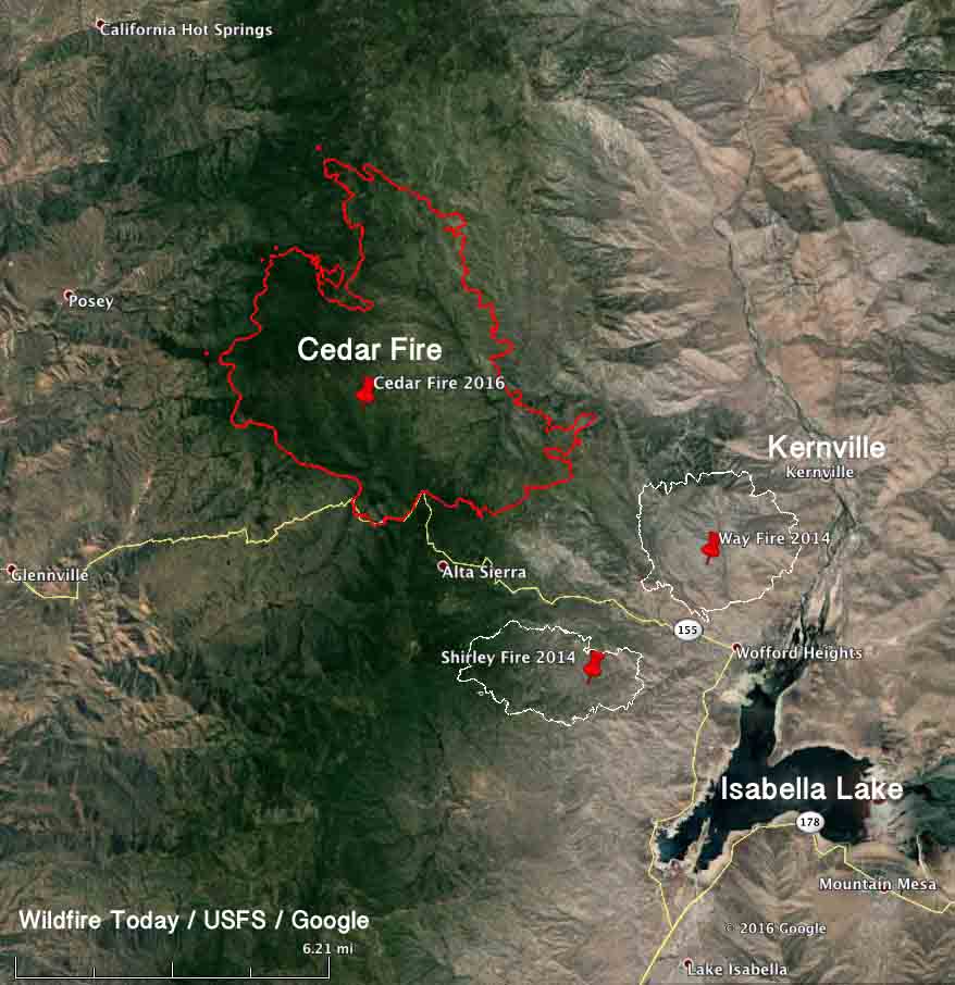
Map of the Cedar Fire
Map of the Cedar Fire at 9 p.m. PDT August 19, 2016. Click to enlarge.

As you can see in the map above, two other large fires occurred in the area in 2014, the Shirley and Way Fires, that burned approximately 2,600 and 4,000 acres respectively. And of course there was also the Erskine Fire in June that blackened about 45,000 acres south of Isabella Lake.

The incident management team provided this information Saturday morning:

No structures have been damaged or destroyed. Firefighters finished wrapping the Tobias Peak and Baker Point Lookouts yesterday, and they remain intact. The significant smoke column that was visible yesterday from nearby communities was generated as the fire burned in the bowl south of Sunday peak on the southwest side. Crews have successfully kept the fire from advancing further south of Highway 155. They continue to brush along the road and mop up along the fireline.

Last night, the fire was active, but less so than the night before. For example, it was primarily backing downslope toward Highway 155 and the community of Panorama Heights. Crews monitored the fire though the night, and on the southeast side they were able to install hose along existing fireline.

One of today’s priorities is to work on perimeter control and hold the fire behind established firelines. Dozer operators will construct more line, and crews with hand tools will fine tune and connect those lines. They will be assisted by aircraft, which are available to water and retardant drops and reconnaissance and mapping flights. Another priority remains the protection of immediately threatened communities.

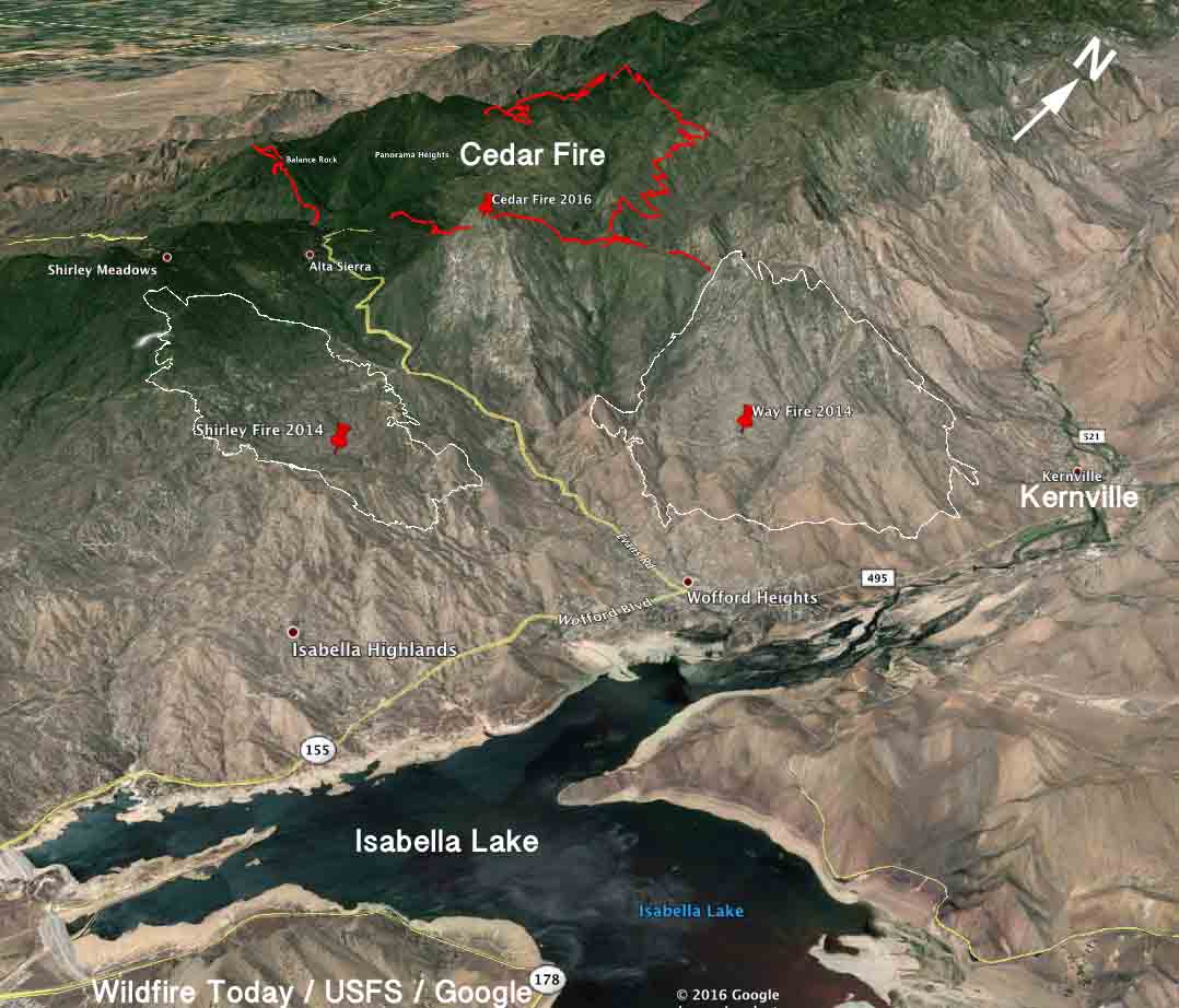
3-D Map of the Cedar Fire
3-D Map of the Cedar Fire at 9 p.m. PDT August 19, 2016. Looking northwest. Click to enlarge.

Red Flag Warnings, August 19, 2016

wildfire Red Flag Warnings

The National Weather Service has posted Red Flag Warnings or Fire Weather Watches for areas in Washington, Oregon, and California.

The Red Flag map was current as of 9:25 a.m. MDT on Friday. Red Flag Warnings can change throughout the day as the National Weather Service offices around the country update and revise their forecasts and maps. For the most current data visit this NWS site.

Photos of ribbons being collected to honor fallen firefighter

Justin Beebe
Justin Beebe. USFS photo.

Photos are being collected of purple ribbons honoring Justin Beebe, the wildland firefighter killed by a falling tree August 13 while fighting the Strawberry Fire in eastern Nevada. The photos will be collected and then posted together on social media as a way to show Justin’s family respect, and honor his life.

If you would like to participate, take a photo of a purple ribbon on anything — a tree, utility pole, sign, fire truck — and Tweet it with the hashtag #rememberjustinbeebe. If there’s a clue in the photo about where in the world the photo was taken, that would be a bonus.

Below are examples.

remember justin beebe

justin bebee


I just ordered 100 yards of purple ribbon and should have it by mid-afternoon on Friday. If anyone in the Hot Springs, SD area wants some, send me a message.

The memorial service honoring Justin will be held at 11:00 a.m., Saturday, August 20 at Ogren Park at Allegiance Field, 700 Cregg Lane, Missoula (map). The public is invited to the memorial to pay their respects.

Justin is from Bellows Falls, Vermont and is a member of the Lolo Hotshots.

Additional information may be found at justinbeebememorial.blogspot.com. Condolences may be sent to justinbeebememorial@gmail.com.

On August 17 Justin was flown in a U.S. Forest Service aircraft from Las Vegas to Missoula accompanied by fellow Hotshot crewmembers and a USFS Honor Guard. From the Missoula airport he was escorted to a funeral home in Missoula where he will rest until the Memorial Service on Saturday.

The Memorial service in Vermont will be on Saturday, August 27 at 1 p.m. at the Bellows Falls Union High School auditorium. The address is 406 Union High School Road, Westminster, VT 05158 (map).

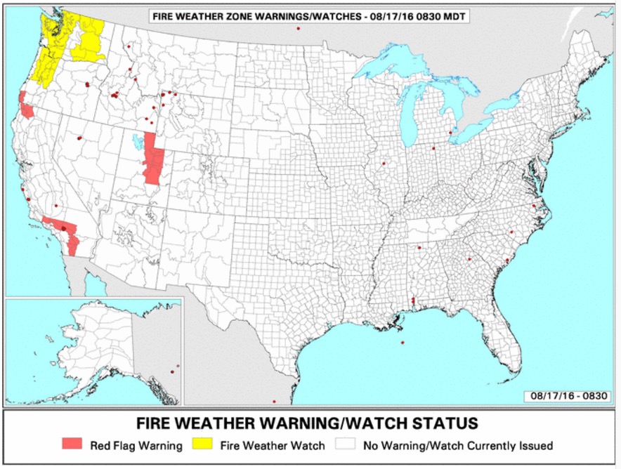
Red Flag Warnings August 17, 2016

Red Flag Warnings August 17, 2016

The National Weather Service has posted Red Flag Warnings or Fire Weather Watches for areas in Washington, Oregon, California, and Utah.

The Red Flag map was current as of 8:40 a.m. MDT on Wednesday. Red Flag Warnings can change throughout the day as the National Weather Service offices around the country update and revise their forecasts and maps. For the most current data visit this NWS site.