A single engine amphibious air tanker made a forced landing Tuesday while working on a wildfire in British Columbia.
“This evening a Conair 802 Air Tractor Fireboss Skimmer aircraft experienced an engine failure during operations on the Connell Ridge Wildfire, near Cranbrook,” said BC Wildfire Service Executive Director Ian Meier. “The pilot conducted a successful forced landing and was transported to receive medical assessment. Our thoughts are with the pilot involved in this incident as well as their family, friends and colleagues. The BC Wildfire Service is providing all possible assistance to the pilot and Conair.”
Jeff Berry, Director of Business Development with Conair Aerial Firefighting confirmed the pilot was able to walk away unharmed from the aircraft to a helicopter and was transported to Cranbrook for assessment by paramedics.
“His skill and training as an aerial firefighting pilot under challenging circumstances enabled him to execute an exceptional emergency maneuver resulting in a safe outcome,” said Berry. “He was faced with a problem with the engine, he went through his emergency procedures, and put the aircraft down in such a way that he was able to walk away unharmed. Faced with a difficult bunch of decisions in a very, very short period, he did exceptionally well.”
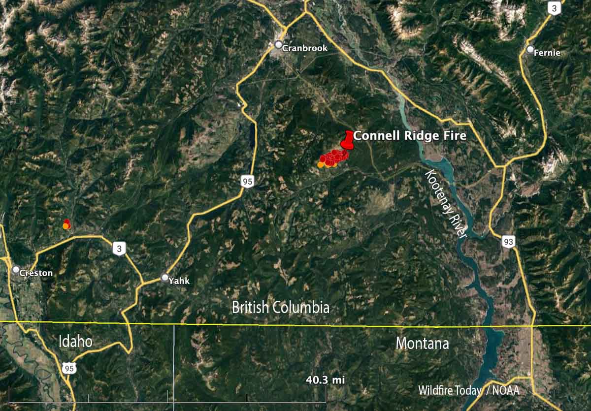
The Connell Ridge Fire 14 miles south Cranbrook, BC has burned approximately 1,235 acres (500 hectares) since it was discovered August 1, 2022.
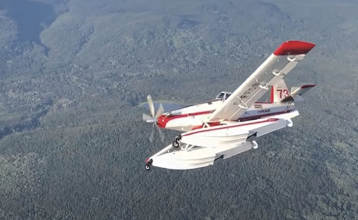
File photo of an Air Tractor 802 Fire Boss operated by Conair. Not necessarily the aircraft involved in the incident.
A Type 1 Incident Management Team will assume command Wednesday
Updated 8:28 a.m. MDT August 3, 2022
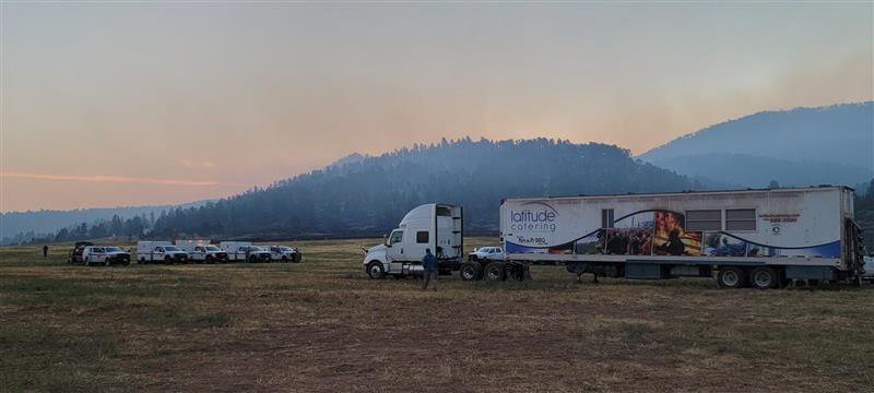
Incident Command Post on the Fish Fire, Wednesday August 2, 2022. IMT photo.
The Fish Fire south of Sundance, Wyoming slowed Tuesday night as the winds decreased and the relative humidity rose to 75 percent.
Fish Fire, August 2, 2022. IMT photo.
The updated forecast for Wednesday predicts mostly sunny skies with a high near 84 with a 6 to 13 mph east wind becoming west or southwest after 11 a.m. Winds could gust as high as 22 mph as the relative humidity drops to 25 percent.
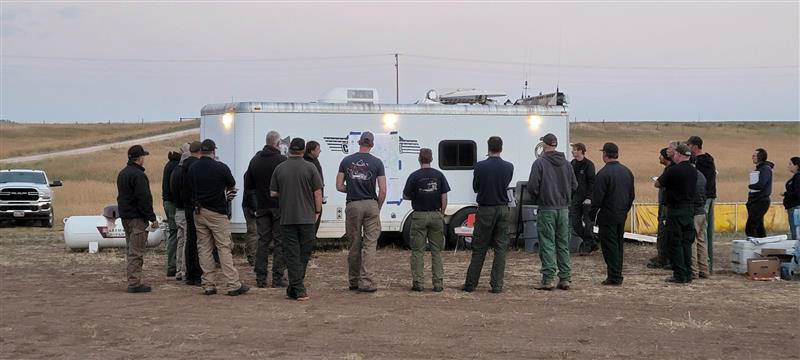
Briefing on the Fish Fire, Wednesday August 3, 2022. IMT photo.
Since it started Sunday July 31 at 11:30 a.m. it has burned 6,476 acres on private and National Forest lands.
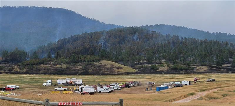
Incident Command Post on the Fish Fire, Wednesday August 3, 2022. IMT photo.
The Rocky Mountain Complex Incident Management Team 1 will assume command of the fire Wednesday morning.
5:30 p.m. MDT August 2, 2022
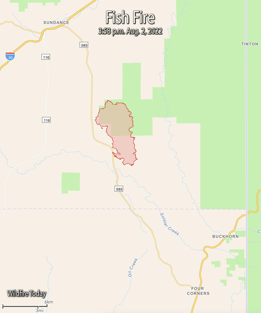
Fish Fire vicinity map, 3:58 p.m. Aug 2, 2022.
The Fish Fire eight miles south of Sundance, Wyoming was much more active Tuesday than in previous days. At 3:58 p.m. it was mapped at 6,476 acres, about eight times larger than it was Monday evening.
To see all of the articles on Wildfire Today about the Fish Fire, including the most current, click HERE.
Monday afternoon and into the evening it was pushed by winds out of the north and northwest gusting to 30 mph. That caused it to spread rapidly throughout the night and by 4 p.m. Tuesday it had grown about 2 miles to the east and four miles south. It spread east across Canyon Springs Road and south across Cold Springs Road. At that time it was still east of Highway 585.
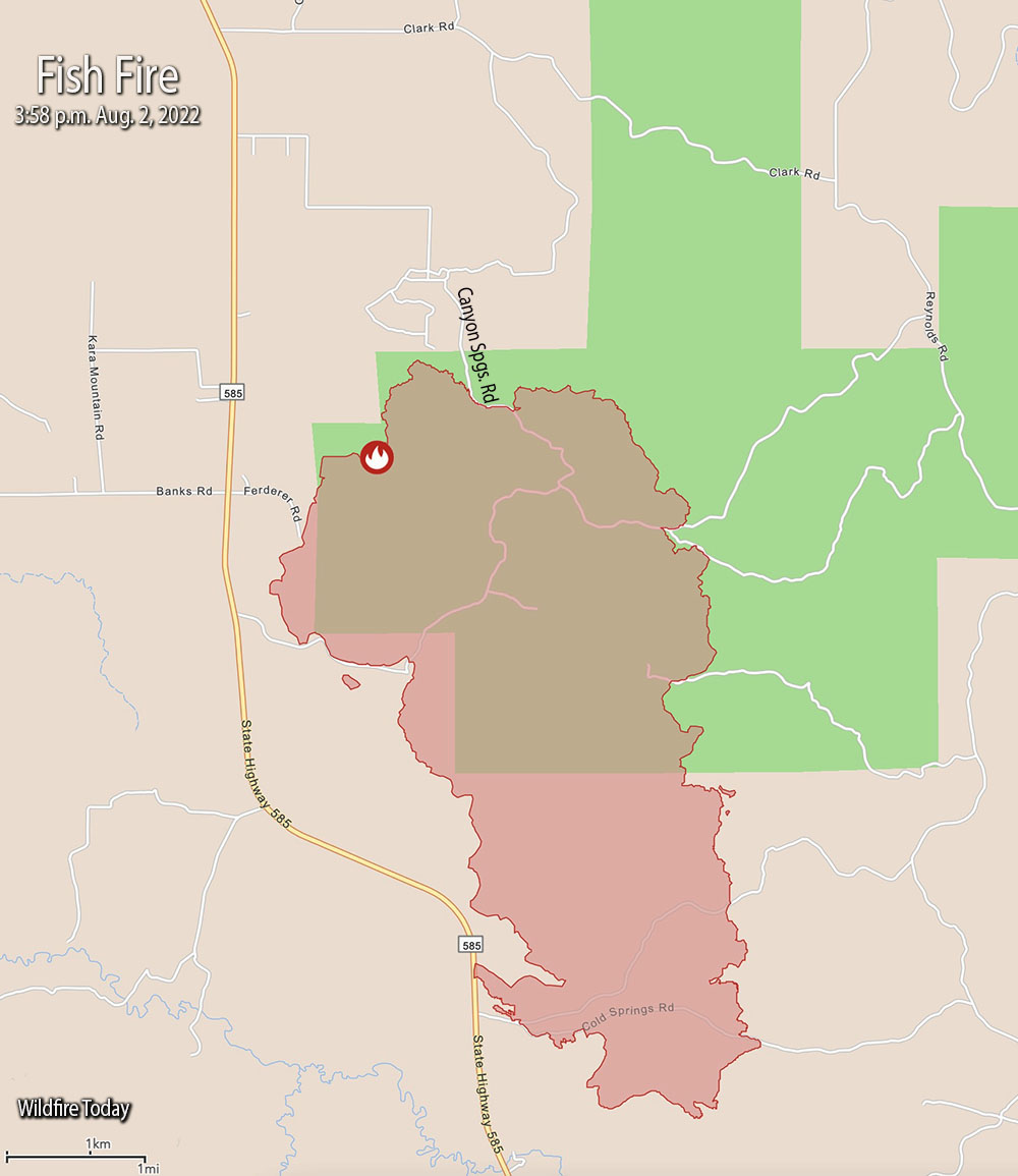
Fish Fire map, 3:58 p.m. Aug 2, 2022.
On Tuesday after 9 a.m. there was a 100 percent cloud cover over the area. In the afternoon winds were out of the northwest at 10 to 15 gusting at 28 to 34 mph while the temperature was 88. The relative humidity rose from 20 percent at 6:30 a.m. to 38 percent at 5 p.m. The forecast for Wednesday calls for mostly sunny skies, 84 degrees, 22 percent RH, and winds from the southwest at 5 to 10 mph.
Evacuation information may be posted on the Crook County Emergency Management Facebook Page, or, Weston County Emergency Management’s Facebook page.
Kim Hemenway, a spokesperson for the fire, said a Type 1 Incident Management Team will arrive Tuesday night and assume command from the Type 3 Team at 6 a.m. Wednesday.
Approximately 250 personnel are assigned.
The article was edited at 7:22 p.m. MDT August 3, 2022 to reflect that the Incident Management Team said their reference to a “Critical Incident Management Team” should have been “COMPLEX Incident Management Team.”
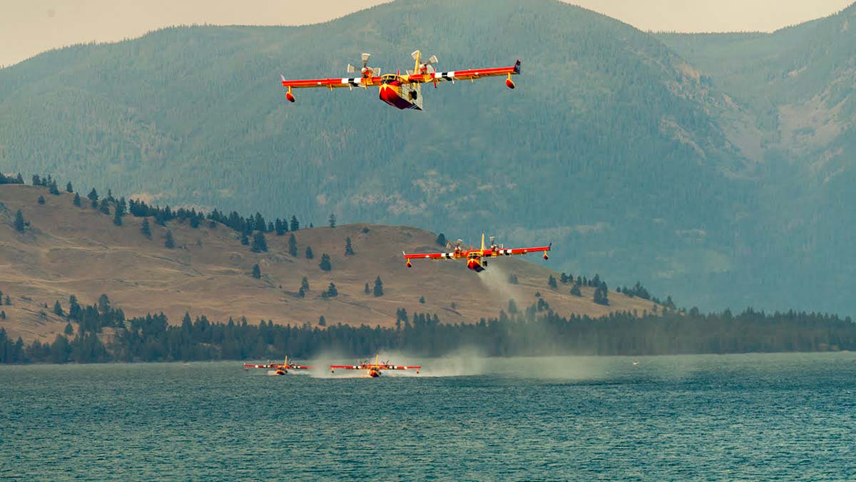
Tim Sheehy, CEO of Bridger Aerospace, said each of the CL-415EAF scoopers dropped 101 times Monday. That is more than half a million gallons of water on the fire.
1:56 p.m. MDT August 1, 2022
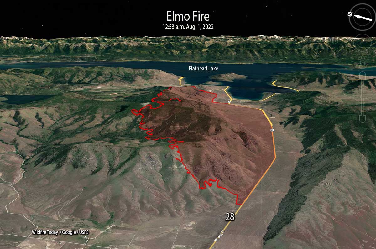
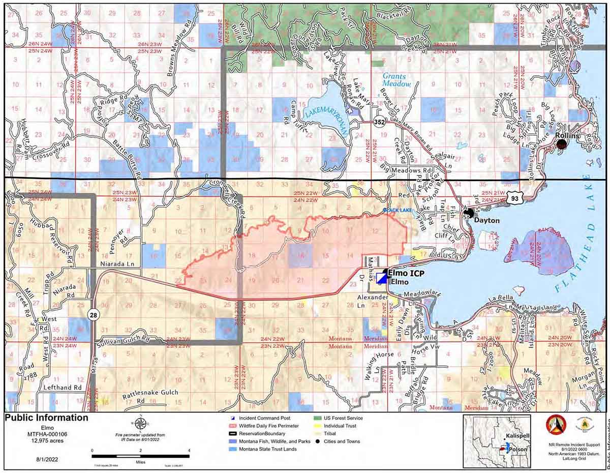
3-D map of the Elmo Fire, looking east at 12:53 a.m. August 1, 2022.
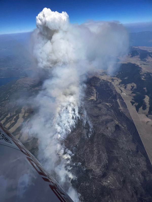
Since the Elmo Fire started Friday afternoon July 29 it has burned nearly 13,000 acres a half mile from the southwest shore of Flathead Lake 22 air miles south of Kalispell, Montana. Firefighters were able to hold the south side at Highway 28 but it spread north uphill into timber and more rugged terrain.
On Sunday the fire grew by about 2,000 acres and was most active in the northwest side in the Cromwell Creek area. Similar fire behavior is expected today, Monday, with short crown runs occurring in narrow strings of timber.
Firefighters were assisted Sunday by four single engine air tankers and four scooping twin engine air tankers, CL-415EAFs, operated by Bridger Aerospace. At times the CL-415EAFs worked together when refilling by scooping on Flathead Lake and dropping in sequence. Sometimes called “super scoopers”, they can each carry up to 1,425 gallons.
Scooping air tankers reload with water on Flathead Lake, Montana while working on the Elmo Fire. Bridger Aerospace photo.
The incident management team reported that the Bitterroot Hotshots worked Sunday in the northwest portion of the fire holding and improving existing line as fire activity allowed. On the northeast side of the fire the Idaho Panhandle Hotshots constructed line to the west.
Crews engaged directly on the fire’s east edge as well with a Type 2 Initial Attack crew working their way to the north. Numerous engines continued to patrol along Highway 28 extinguishing any remaining heat close to the road.
Elmo Fire near Flathead Lake, Montana. Bridger Aerospace photo.
Today firefighters along with heavy equipment and aviation resources will continue to hold and improve previously constructed fireline. Crews will construct direct fireline where possible and scout for other opportunities as needed.
Map of Elmo Fire, morning of August 1, 2022.
Highway 28 is now open, but drivers may experience low visibility due to smoke.
Resources on the fire Sunday evening, in addition to the air tankers, included a Type 2 incident management team (Northern Rockies Team 7), six hand crews, 26 engines, and 3 helicopters for a total of 293 personnel.
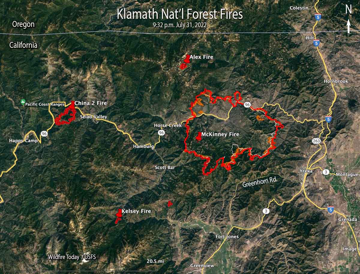
McKinney and other fires on or near the Klamath National Forest, 9:32 p.m. July 31, 2022.
The Siskiyou County Sheriff’s Office announced early Monday morning that at about 10 a.m. Sunday two individuals were found deceased in a burned vehicle in the path of the McKinney Fire in Northern California. The vehicle was in a residential driveway along Doggett Creek Road off Highway 96 west of the community of Klamath River, California.
To see all articles on Wildfire Today about the McKinney Fire, including the most recent, click HERE.
Rain on the west side of the fire very early Sunday morning and a heavy smoke inversion helped limit growth Sunday, but also kept aircraft mostly grounded. The weather station on Mt. Baldy on the western edge of the fire received just over half an inch, Scott Barr three miles west of the fire got 0.19″, and Oak Knoll off Highway 96 received 0.01″. Several locations near Yreka recorded no precipitation.
Map of the McKinney Fire at 9:32 p.m. PDT July 31, 2022. The brown areas represent intense heat.
The fire was mapped Sunday night at approximately 55,493 acres. It is being managed under Unified Command with the US Forest Service and the CAL FIRE.
Saturday night the McKinney Fire was:
5 miles from Yreka
6 miles from Interstate 5
9 miles from Fort Jones
4 miles from Scott Bar
2 miles from Horse Creek
The Siskiyou County Sheriff’s Office ordered evacuations of more than 2,000 people near Yreka. Details can be found on their Facebook page. A Zonehaven Aware map is also available.
The Siskiyou County Sheriff’s Office has confirmed that several structures have been destroyed. Sheriff’s office Spokeswoman Courtney Kreider said residences along Highway 96 in the Klamath River drainage burned. She did not have a specific number. An online video shows that the Community Hall in Klamath River burned.
At least 10 fires, including the McKinney Fire, were burning in Siskiyou County as of late Sunday night, according to the Siskiyou County Office of Emergency Services.
Fire officials said the spread of the Alex Fire near Condrey Mountain four miles north of the McKinney Fire has been stopped. It was mapped at about 140 acres.
The China Fire west of Seiad has burned 1,989 acres south of Highway 96.
The Kelsey Fire was 10-15 acres Sunday afternoon and has evacuation orders in place. Numerous resources are on scene and more continue to arrive. It is west of Scott River Road nine air miles southwest of Scott Bar.
Highway 96 is closed and Interstate 5, which is six miles east of the fire, remains open.
Monday’s weather forecast calls for a 25 percent chance of showers and isolated thunderstorms with a high of 80 to 93 degrees with the humidity dropping into the 20s in the lower elevations. The wind will be out of the west at 4 to 7 mph with gusts to 14 mph.
Another fire, the Carter Fire, has burned more than 10,000 acres near Scotts Bluff, Nebraska
Updated 8:46 p.m. MDT August 1, 2022
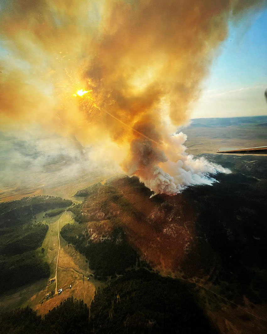
Tanker 40, a BAe-146, drops near the Fish Fire south of Sundance, WY, August 1, 2022. USFS photo.
Fish Fire
The Fish Fire eight miles south-southeast of Sundance, Wyoming spread to the east Monday threatening the Canyon Springs subdivision. Crews are working in the area to provide protection to the structures. Monday afternoon it had burned about 750 acres.
To see all of the articles on Wildfire Today about the Fish Fire, including the most current, click HERE.
Residences from Canyon Springs Road to the south end of the fire and east of Wyoming Highway 585 are still under evacuation.
The fire started on private land and was human-caused.
A Wyoming Type 3 incident management team is expected to arrive and in-brief Monday at 6 p.m.
The smoke from the fire is blowing east into South Dakota toward Lead and Rapid City .
It is a fairly big air show for that part of the country. We checked a flight tracking app late in the afternoon Monday and spotted four large air tankers at the fire or at the Rapid City Tanker Base 63 miles to the southeast — two BAe-146s and two RJ85s. Tanker 168, an RJ85, flew up from Abilene, dropped, and headed to Rapid City. There are also two Type 1 helicopters and a Type 3 helicopter assisting firefighters.
The state of Colorado’s PC12 multi-mission aircraft is also on scene for mapping and intelligence support. It found that at noon the fire had burned 527 acres.
Monday afternoon the Four Corners weather station south of the fire recorded 88 degrees, 13 percent relative humidity, and 10 to 20 mph winds gusting out of the west and northwest up to 32 mph. The forecast for the fire on Tuesday predicts 87 degrees, 21 percent RH, and 10 to 15 mph south winds shifting to the west in the afternoon gusting up to 20 mph.
Carter Canyon Fire
The Carter Canyon Fire seven miles southwest of Scotts Bluff, Nebraska has grown to 15,592 acres. The blaze destroyed three homes and damaged several more in the Carter Canyon community that was evacuated Sunday.
The temperature at the fire reached 102 degrees Monday with 16 percent RH and winds gusting at 10 to 15 mph. The National Weather Service forecasts temperatures around or in excess of 100 degrees over the next six days.
Large air tankers have also been assisting firefighters on the Carter Canyon Fire.
Updated at 9:54 a.m. MDT August 1, 2022
Fish Fire, July 31, 2022. Photo by Scott McDermid, Air Attack.
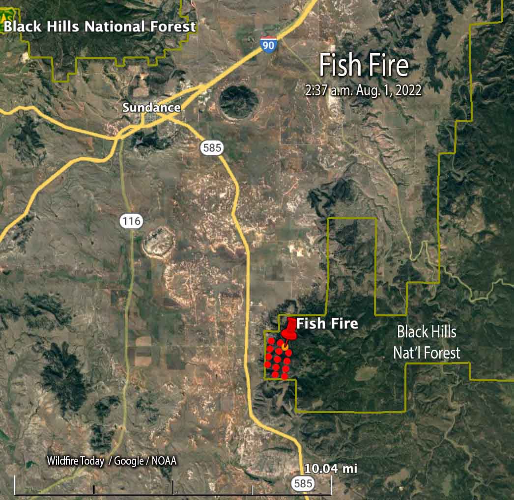
The map below shows heat detected by a satellite as it passed over the Fish Fire at 2:37 a.m. Monday.
The red dots on the map represent heat detected by a satellite on the Fish Fire at 2:37 a.m. MDT Aug. 1, 2022.
We will update this article as more information becomes available.
10:20 p.m. MDT July 31, 2022
Map showing the location of the Fish Fire at 12:43 p.m. MDT July 31, 2022.
The Fish Fire 8 miles south-southeast of Sundance, Wyoming is prompting evacuations south of the city. Evacuation orders are in effect from south of Canyon Springs Road to the south end of the fire, and east of Wyoming Highway 585.
Since it was reported at about 11:30 Sunday morning it burned approximately 500 acres on the Black Hills National Forest by 7 p.m., according to fire officials. Air tankers and at least one Type 1 helicopter are assisting firefighters.
A Wyoming Type 3 incident management team is expected to arrive on Monday.
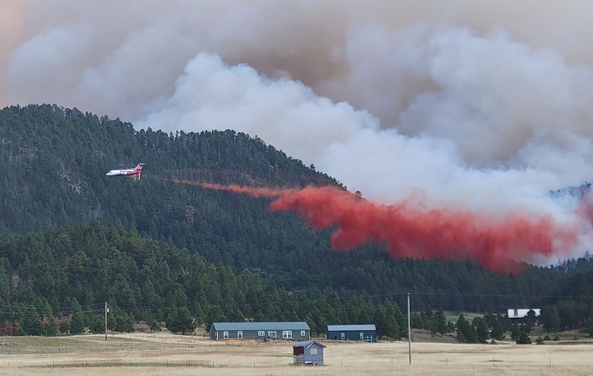
Fish Fire, July 31, 2022, by @LordBaumeister.
Another fire in the Northern Great Plains has been burning since 6:30 p.m. on July 30 seven miles southwest of Scotts Bluff, Nebraska. The Carter Canyon Fire has grown to approximately 13,000 acres, with part of it being within the Cedar Canyon Wildlife Management Area south of Carter Canyon.
Single engine air tankers as well as large air tankers have been working on these fires, flying out of Rapid City and Rocky Mountain Metropolitan Airport (Jeffco) near Denver. An air attack aircraft flew over from Cody, Wyoming to assist with the Fish Fire on Sunday.
The symbols represent heat detected by satellites on the Carter Canyon Fire as late as 12:41 p.m. MDT July 31, 2022. Parts of the fire are in light vegetation such as grass that cools quickly after burning rapidly and can be missed by the twice daily satellite overflights.
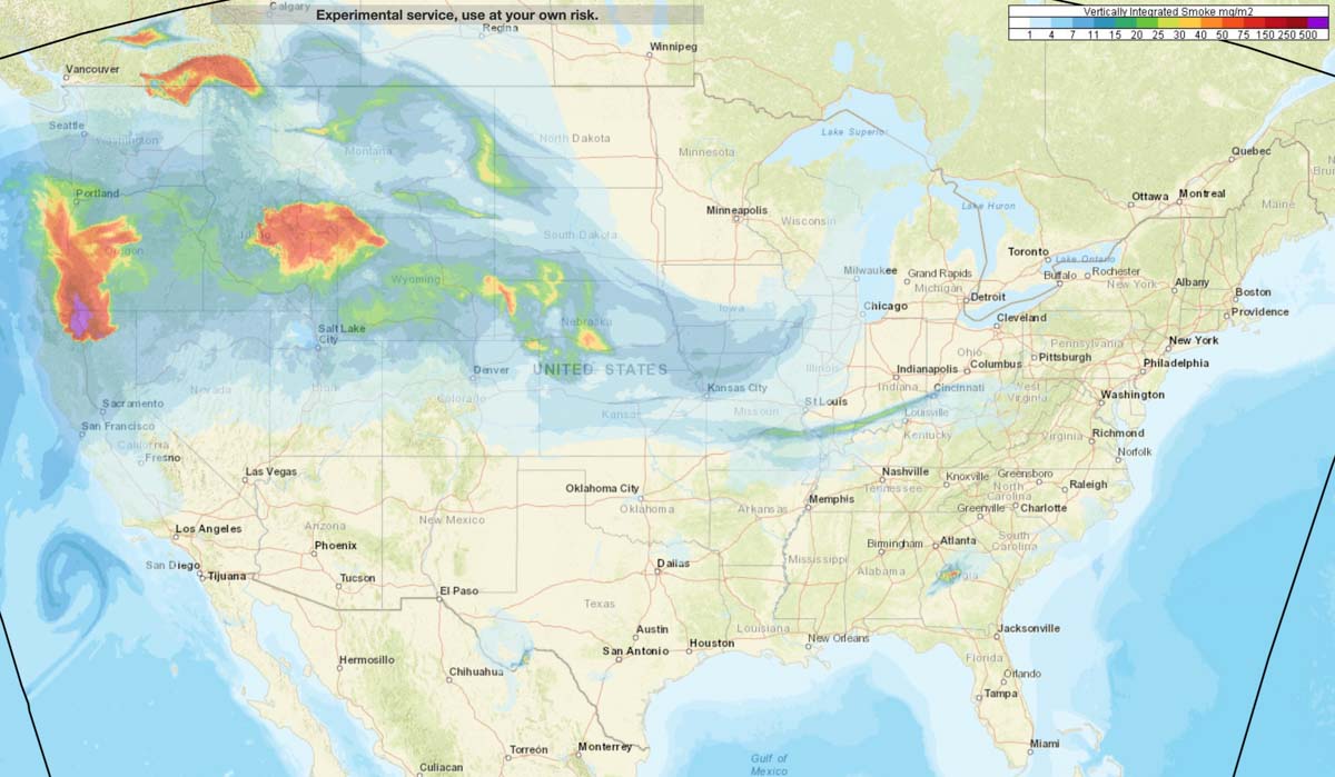
Wildfire smoke forecast for 11 p.m. MDT July 31, 2022.
Smoke from wildfires may be noticeable Sunday in northern California and the northwest, including Oregon, Washington, Idaho, Montana, and Wyoming.
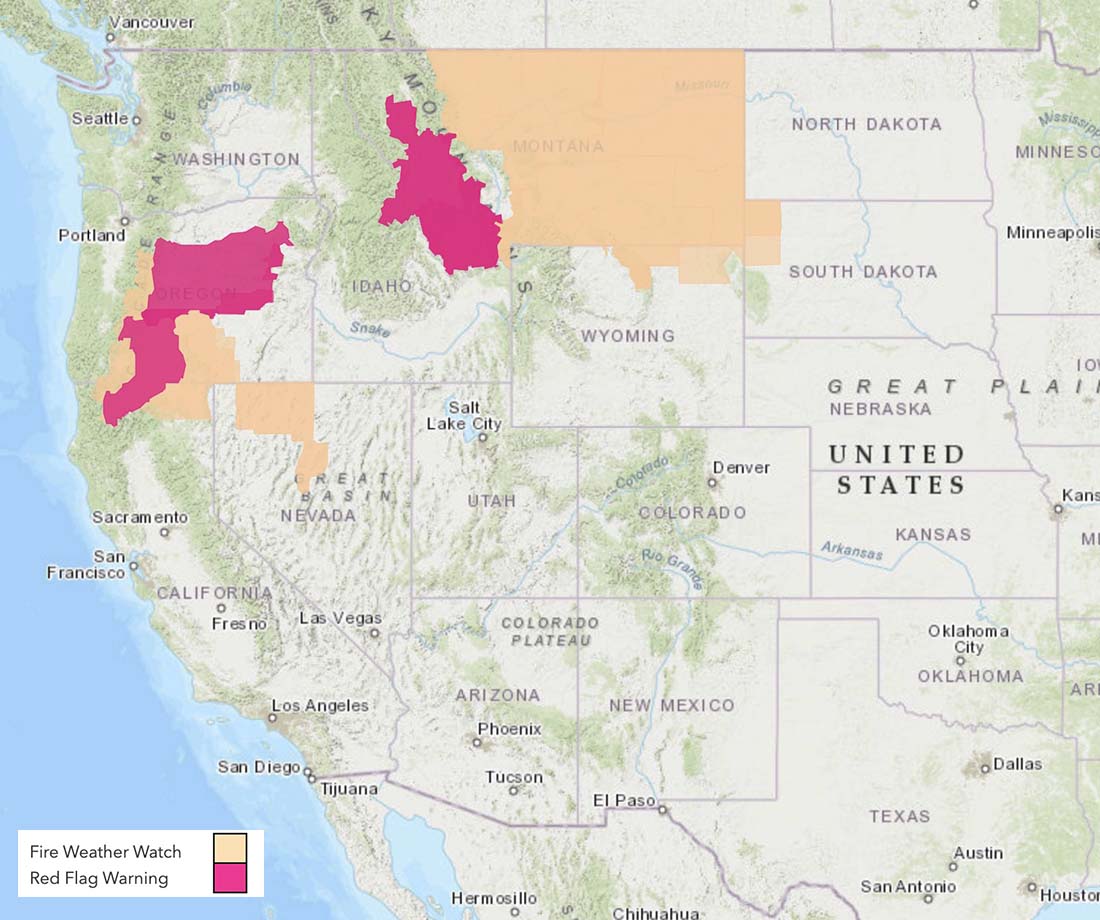
Red Flag Warnings are in effect Sunday for portions of California, Oregon, Idaho, and Montana. The Red Flag Watches on the map are for extreme fire danger on Monday.