Firefighters are making good progress on the Jim Fire in the Cleveland National Forest in Southern California. On Thursday several air tankers and helicopters were assisting firefighters. There has been no mention of the fire spreading any more Thursday.
There has been no reported change in the size, and is still 553 acres.
The cause of the fire is officially still under investigation, but the Desert Sun reported that U.S. Marines were working with explosives in the general area about the time the fire broke out.
From the Sun:
Marine engineers from Camp Pendleton were in the area using explosives to demolish old dams, authorities said, as part of a long-running project to restore creek habitat for steelhead trout.
“There was a crew working in the area yesterday, but the fire is still under investigation,” said Nathan Judy, spokesperson for the Cleveland National Forest. “Forest Service law enforcement will be headed into that area to do the investigation.”
The video below from the FIRIS aircraft shows an air tanker dropping, and using infrared, the amount of heat remaining on the fire.
OCFA’s FIRIS Intel 12 on the Jim Incident showing retardant dropping on the Mike/Zulu Divisions. pic.twitter.com/7KBDccKmZO
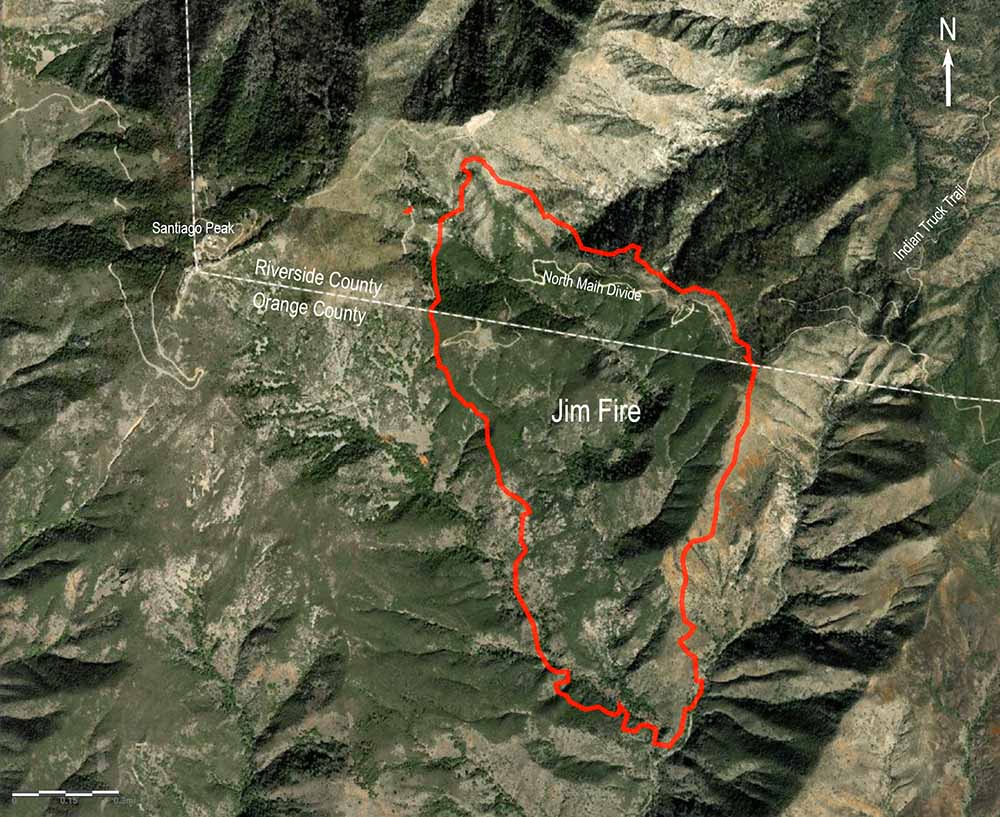
The Jim Fire that started near Holy Jim Canyon spread very little after the late afternoon on Wednesday. The Cleveland National Forest said Thursday morning it has burned 553 acres. Today crews will continue to build hand and dozer lines around the fire and utilize water-dropping helicopters to assist with any remaining hotspots. Air tankers will be on standby to respond if needed.
It began in Orange County in Southern California Wednesday morning and burned uphill and north across the North Main Divide Truck Trail and into Riverside County.
As you can see in the photo below the fire is fairly quiet Thursday morning, with some interior heat still present.
Jim Fire, looking east-southeast from Santiago Peak at 8:42 a.m. March 3, 2022.
The thermal video below shows heat on the fire at 10:32 p.m. on Wednesday.
OCFA’s FIRIS Intel 12 showing a more detailed view at the head of the Jim Incident at 22:32 hours. pic.twitter.com/IkEwWf4ZYs
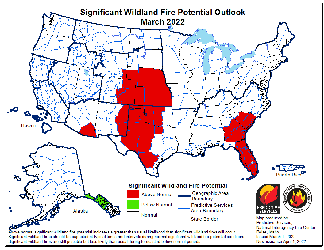
The forecast for wildland fire potential issued March 1 by the National Interagency Fire Center predicts that in March the potential for wildfires will be higher than average in Florida, Georgia, South Carolina, and the central and southern plains.
The data from NIFC shown here represents the cumulative forecasts of the ten Geographic Area Predictive Services Units and the National Predictive Services Unit.
Below:
Excerpts from the NIFC narrative report for the next four months;
Additional NIFC monthly graphical outlooks;
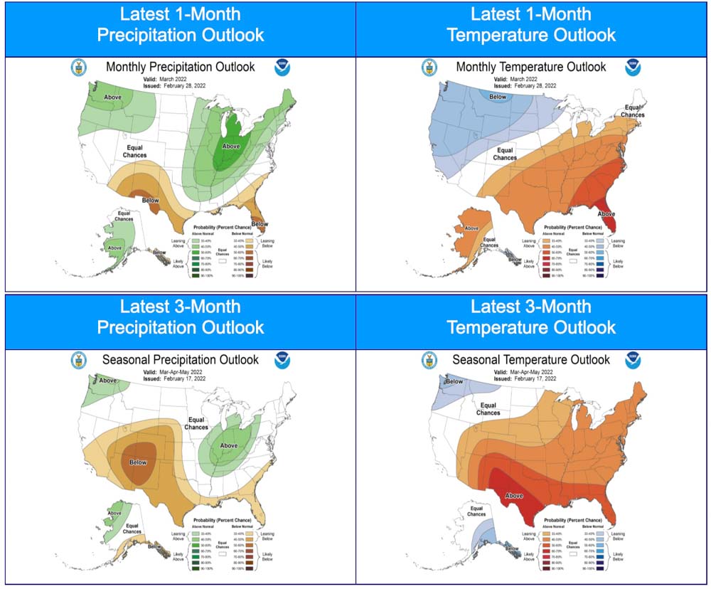
NOAA’s three-month temperature and precipitation forecasts;
Drought Monitor;
Keetch-Byram Drought Index;
Soil moisture.
“Most of the West, Plains, and Texas remain in drought, with abnormally dry conditions now across Florida and continuing in portions of the Carolinas.
“Climate outlooks through spring indicate areas receiving below normal precipitation will likely expand generally south to north across the West, with below normal temperatures likely continuing across the Pacific Northwest and northern Rockies. Much of the Great Lakes and Northeast are forecast to have above normal precipitation through spring, with near to above normal temperatures across the central and eastern US. Additionally, there are indications for an active severe weather pattern this spring from eastern portions of the Plains into the Southeast and Ohio Valley. Critically dry and windy periods will accompany the severe weather for much of the Plains, especially the southern and central High Plains.
“Above normal significant fire potential is forecast to expand across Florida, Georgia, and the Carolinas during March and April, with lingering above normal potential forecast to remain in Florida during May. Much of the central and southern Plains are expected to have above normal significant fire potential into April, while persisting on the High Plains and eastern slopes of the Front Range into June. Above normal potential is forecast in portions of south Texas and the Hill Country during March, with the westward retreat of above normal potential in Oklahoma, Kansas, and Texas following the expected green-up procession.
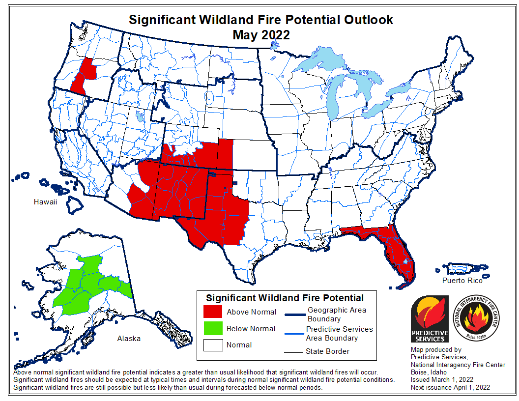
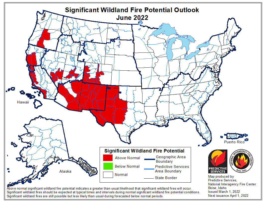
Most of the Southwest is forecast to have above normal significant fire potential in May and June, with potential increasing across southern and western Colorado and southern portions of the Great Basin. Central Oregon is likely to have above normal significant fire potential in May and June, with above normal potential forecast across much of coastal California by June. Alaska is forecast to have below normal potential in its panhandle through April, with below normal potential expected across large portions of the Interior in April and May.
Temperature & precipitation outlook, 1 and 3 month. Feb. 28, 2022.
Cherry Canyon Fire, 58 miles east-northeast of Trinidad, Colorado, May 24, 2020. Photo: Colorado Fire Prevention & Control.
A television station in Denver, 9News, reports that some firefighters in the state, especially volunteers, do not have the necessary personal protective equipment (PPE) to reduce their risks when fighting fires.
A bill recently passed by the legislature that appropriates $5 million to help provide the gear is waiting on the Governor’s desk for a signature.
The additional funding will most likely address PPE for all types of fires, including self contained breathing apparatus for hazardous material incidents and structure and vehicle fires. As Wildfire Today reported December 22, 2021, a recent survey conducted by the NFPA asked 26,000 fire departments of all sizes about their readiness and capability for suppressing wildland fires. Here are three of the questions.
Excerpt from the Wildland Fire section of the NFPA Needs Assessment.
Cameron Peak Fire smoke plume at Boyd Lake, InciWeb, Oct. 14, 2020.
In an effort to improve forest resilience and reduce the risk of catastrophic wildfires in the Interior West, three organizations are receiving a total of $20 million from the U.S. government.
The funds are part of the Infrastructure Investment and Jobs Act passed by Congress with bipartisan support and signed by President Joe Biden in 2021, which will go to enhancing key systems and processes to mitigate the impact of forest fires.
The award will be made to the Southwest Ecological Restoration Institutes (SWERI) which includes the Colorado Forest Restoration Institute (CFRI), Highlands University’s New Mexico Forest and Watershed Restoration Institute, and Northern Arizona University’s Ecological Restoration Institute. The SWERI were created through congressional legislation passed in 2004 which charged the three institutes with promoting adaptive management practices to restore the health of fire-adapted forest and woodland ecosystems of the Interior West.
The Colorado Forest Restoration Institute is housed in the Department of Forest and Rangeland Stewardship in CSU’s Warner College of Natural Resources.
The three institutes will work collaboratively on three key components with the funding, to:
Develop a national database of existing data on fuel treatments and wildfires,
Work with managers, planners, and policymakers to facilitate use and applications of the data, and,
Research outcomes of forest management and wildfires to learn what works.
“The work we’re charged with developing under the Infrastructure measure will create opportunities for land and fire managers, scientists and community stakeholders to co-produce actionable knowledge to lessen the harmful effects of wildfire events to people and the environment,” said Tony Cheng, director of the CFRI and professor in the Department of Forest and Rangeland Stewardship.
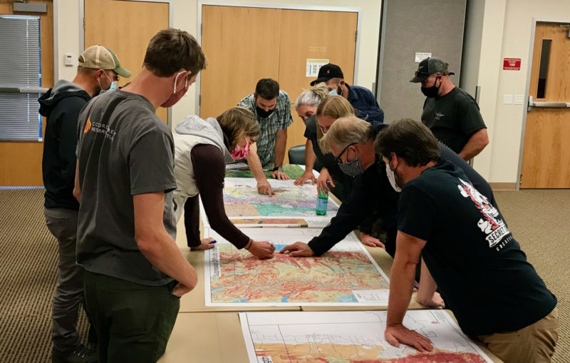
Land and fire managers and community stakeholders in Boulder County huddled around CFRI geospatial mapping products aided by CFRI’s science and outreach staff. Photo by Tony Cheng.
According to Cheng, the new funding aligns with the CSU land-grant mission and offers an opportunity to grow CFRI’s existing data management, application, and research efforts to be accessible for a wider audience.
The funding is prompted by climate change-driven increases in fire activity and fire season length, continued development in the wildland-urban interface, and interactions between fire and disturbances like pest and pathogen disturbance.
The CFRI recently completed a statewide database of forest vegetation management and wildfires for Colorado, complementing a similar effort for New Mexico and southern Colorado led by the New Mexico Forest and Watershed Restoration Institute. The data serve as a foundation for the decision support tools and collaborative processes that CFRI deploys around the state and throughout the Interior West. The national database will be developed using similar types of data across the country.
The data are only the starting point, said Brett Wolk, one of CFRI’s assistant directors. Making data meaningful for land and fire managers, scientists, policymakers, and community stakeholders working in their specific places is a critical function the institutes excel at and is called out in the Infrastructure provisions.
“Unless the data is situated within a social context where people can understand how it applies to their work, all the best data and science in the world won’t change decisions or outcomes on the ground,” said Wolk. “That’s why SWERI works to co-develop solutions with partners and empower decisions that are science informed but also locally relevant.”
A third component of the funding is researching outcomes of past treatments to improve future decisions. This will build on deep research expertise at the Arizona and Colorado institutes, exemplified by a recent CFRI co-led publication and accompanying podcast evaluating accomplishments of the Forest to Faucets partnership aimed at protecting Denver’s water supply from devastating wildfires.
The challenge, Wolk said, is applying the collective institutes’ knowledge and expertise across the entire U.S. At the same time, there is an opportunity for other states to benefit from the collective knowledge across the institutes.
“It’s a massive opportunity to help fast-track implementation of what’s working in forest and fire management. But research also shows big gaps in who has access to and contributes knowledge towards these forestry data and decision-making processes. If we can increase the application of science, while making incremental change to expand equity of ideas and resources among wider audiences, those will be our measures of success.”
The agency employs approximately 1,000 wildland firefighters
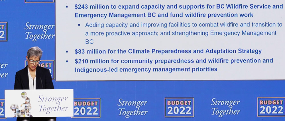
Minister of Finance Selina Robinson presented the 2022 budget for British Columbia on February 22, 2022.
The government of British Columbia intends to move to a year-round workforce for the Wildfire Service in the next fiscal year that begins April 1. In a February 22 presentation Minister of Finance Selina Robinson said, “$145 million in new funding will strengthen B.C.’s emergency management and wildfire services. The BC Wildfire Service will shift from a reactive to a proactive approach by moving to a year-round workforce that will deliver all pillars of emergency management: prevention and mitigation, preparedness, response and recovery.”
The BC Wildfire Service employs approximately 1,000 wildland firefighters each year.
The new budget will allow improvements of the public alerting system for wildfires and help support people and communities during climate-related events.
An additional $98 million will fund wildfire prevention work and maintain forest service roads used to respond to forest fires.
The budget also includes $210 million to support community climate change preparedness and emergency management, including through the FireSmart program, the Community Emergency Preparedness Fund, and Indigenous-led emergency management priorities. It will support communities and First Nations to build more resilient dikes and map floodplains.
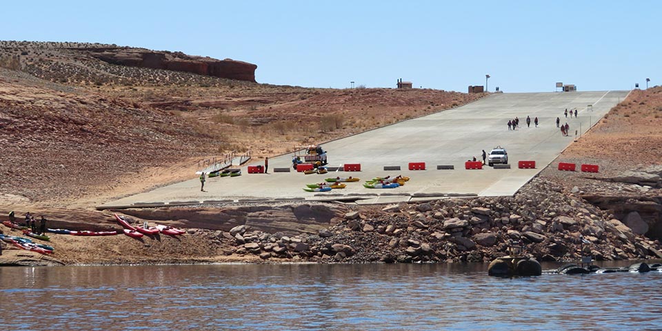
The public launch ramp at Antelope Point in late March, 2021 at Lake Powell, Glen Canyon National Recreation Area. NPS photo.
New research published this month shows that the current drought in the Western United States is the worst seen in data going back to the year 800. Scientists developed estimates of precipitation during previous centuries using tree-ring reconstruction and found 2000–2021 was the driest 22-year period in the last 1,200 years.
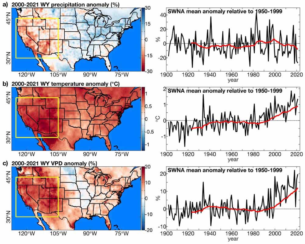
Observed climate anomalies. Anomalies in water-year (WY: October–September) (a) precipitation total, (b) temperature, and (c) vapour-pressure deficit (VPD). Maps on left show the average WY anomaly during 2000–2021. Yellow box: Southwestern North America (SWNA) study region. Anomalies are relative to 1950–1999. Time series on right show regionally averaged WY anomalies in SWNA (black) annually and as (red) 22-year running means visualized on the final year in each 22-year period. Geographic boundaries in maps were accessed through Matlab 2020a. From the paper.
Since the year 2000, southwestern North America (SWNA) has been unusually dry due to low precipitation totals and heat, punctuated most recently by exceptional drought in 2021. From 2000 to 2021, mean water-year (October– September) SWNA precipitation was 8.3 percent below the 1950–1999 average and temperature was 0.91 °C above average.
In summer of 2021, water levels at Lakes Mead and Powell, both on the Colorado River, reached their lowest levels on record, triggering unprecedented restrictions on Colorado River usage, in part because the 2-year naturalized flow out of Colorado River’s upper basin in water-years 2020–2021 was likely the lowest since at least 1906. Despite an active North American monsoon in 2021, the United States Drought Monitor classified more than 68 percent of the western United States as under extreme or exceptional drought for nearly all of July–October, 2021.
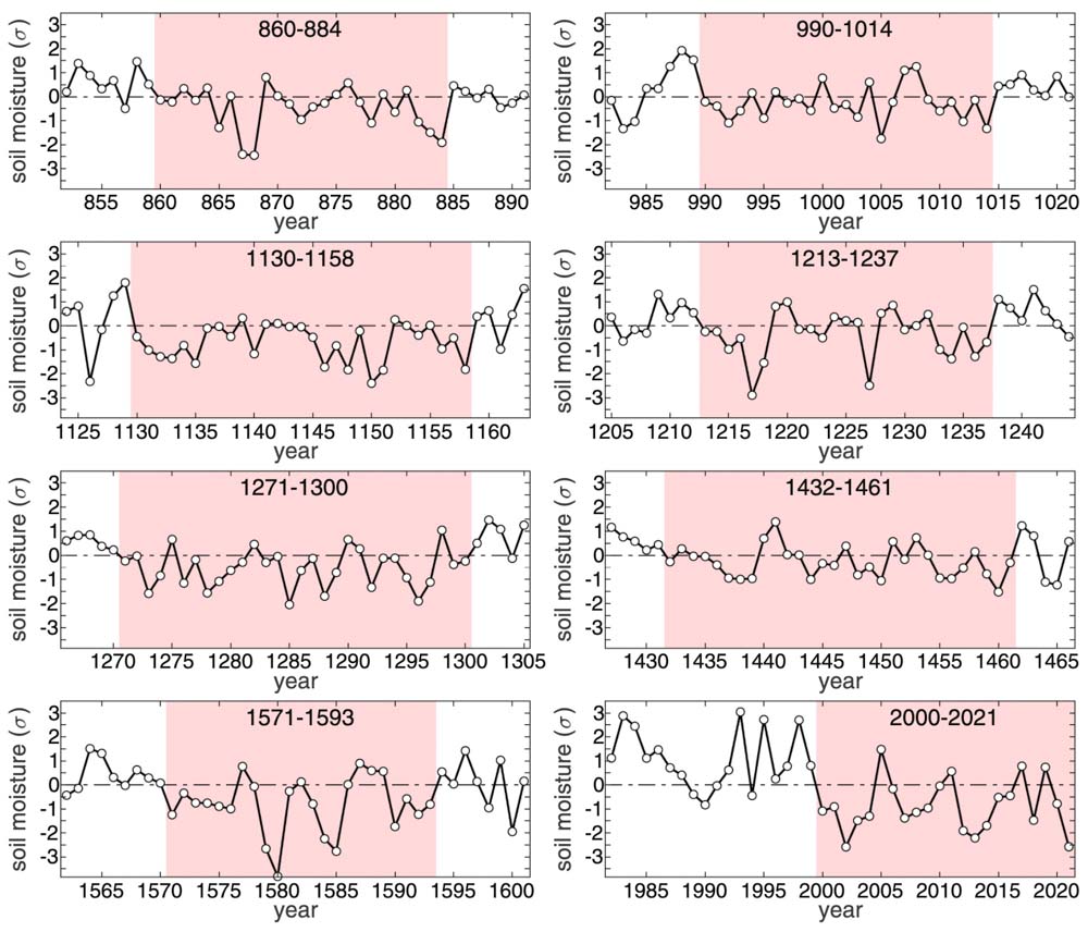
Extended drought events. Summer soil moisture anomalies, expressed as standard deviations from the 800–2021 mean (σ), during the longest 8 extended drought events during the 800–2021 study period. The pink background bounds the years of each extended drought event. The horizontal dotted black line represents the 800–2021 mean. For the first 7 droughts shown, soil moisture anomalies come from our tree-ring reconstruction. For the final drought (2000–2021), anomalies come from our observation-based record. From the paper.
The researchers concluded that anthropogenic climate change accounts for 42 percent of the SWNA soil moisture anomaly in 2000–2021 and 19 percent in 2021.
Drought can have a very significant effect on wildland fire behavior. It affects vapor pressure deficit (VPD), soil moisture, relative humidity, and moisture in live and dead vegetation, or fuels. VPD is an absolute measure of the moisture deficit of the atmosphere and is more closely related to water stress on vegetation than relative humidity.
Soil moisture is a particularly important integrator of drought. Of all 22-year periods since 800, only two (1130–1151 and 1276–1297) contained more years with negative soil moisture anomalies than the 18 observed during 2000–2021.
The authors wrote that the 22-year long current drought is highly likely to continue through a 23rd year.
Extreme and exceptional drought in the western United States (US). Weekly percentage of western continental United States (west of 103°W) classified by the United States Drought Monitor (USDM) as under extreme or exceptional drought from January 1, 2000 to December 28, 2021. Calculations were made form weekly shapefiles of USDM drought classifications, available at https://droughtmonitor.unl.edu/DmData/GISData.aspx as of January 9, 2022. The USDM is developed by the National Drought Mitigation Center (NDMC), the U.S. Department of Agriculture (USDA) and the National Oceanic and Atmospheric Administration (NOAA). From the paper.
The research was conducted by A. Park Williams, Benjamin I. Cook, and Jason E. Smerdon.