Estimated value of those Boulder County, Colorado homes is $513 million
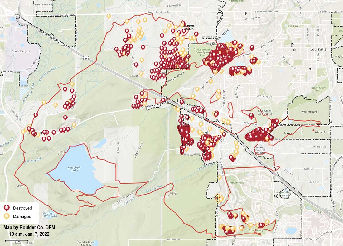
Map of structures damaged or destroyed during the Marshall Fire which started December 30, 2021. Map accessed at 10 a.m. MST January 7, 2021.
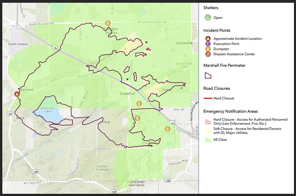
An interagency damage assessment of the Marshall Fire southeast of Boulder, Colorado updated Jan. 6 has found 1,084 destroyed residences and 149 that were damaged. The total countywide estimated value of residential damage is $513,212,589. The updated numbers for commercial structures are 7 destroyed and 30 damaged. The total value of commercial damage is still being calculated. The commercial structures included a shopping center and the Element Hotel.
Residential Structures
City of Louisville: 550 destroyed, 43 damaged; actual value of residential damage is approximately $229,199,184
Town of Superior: 378 destroyed, 58 damaged; actual value of residential damage is approximately $152,757,462
Unincorporated Boulder County: 156 destroyed, 48 damaged; actual value of residential damage is approximately $131,255,944
Within hours it burned more than 6,000 acres and nearly 1,000 structures southeast of Boulder, Colorado
FEDEX truck blown over by wind, with the Marshall Fire in the distance. Photo by Alyssa Lundgren, Dec. 30, 2021.
It seems hard to believe, but the the first firefighters and a sheriff’s deputy dispatched to the Marshall Fire southeast of Boulder, Colorado could not immediately find it. On December 30 they arrived four minutes after being dispatched at about 11 a.m. to a report of smoke and a downed power line, according to a time line compiled by Colorado Public Radio, but they did not see smoke or flames until 11 minutes after they were at the reported location.
They may have been distracted at first by what they thought was a downed power line on Marshall Road. They told the dispatcher the line is “hanging down low enough that it can touch a vehicle or trucks and people are attempting to go underneath it.” Later they found out that it was a telecommunications line that did not pose any fire danger, but apparently it was a physical hazard for motorists.
It is possible that the 11-minute delay in finding the fire was due the reported location being incorrect. Or the fire was small and light fuel such as short grass was burning which did not produce a great deal of smoke and may have been kept low to the ground by the very strong wind. Later the blaze moved into heavier fuel, and in spite of the wind produced a convection column topped by condensation.
Marshall Fire south of Boulder, CO. Posted Thursday at 12:26 p.m. MST by County Commissioner Claire Levy.
During the hour before it started, firefighters were sent to two other vegetation fires which were north of Boulder. Even with the very strong winds firefighters were able to stop both before they grew large.
These incidents may have reduced the number of fire resources that were available when the Marshall fire took off, spreading very rapidly pushed by winds gusting at 60 to more than 100 mph hour depending on the location.
Before the fires started a great deal of dust was being kicked up by the wind, then it became a mix of smoke and dust. Check out the dust blowing in this video with the fire in the background:
The wind was not predicted very far in advance for the Boulder area and there was no Red Flag Warning in effect. At 3 a.m. on December 30, about 8 hours before the Marshal Fire started, the forecasting data and models started to become clear — the wind would move from the mountains into the areas northwest of Denver. An existing wind warning was revised.
From CPR.org:
“It wasn’t a slam dunk high wind event,” said Jennifer Stark, meteorologist in charge at the Boulder office. “But ingredients were really coming together, and once we saw the latest model runs that forecaster on the midnight shift, put out that warning. And we were expecting wind gusts up around 90 miles an hour.”
Before the day was over winds would gust up to 115 mph at one location.
The warning, however, was not technically a “red flag” warning, which is specific to fire danger, and requires three elements: strong winds, cured fuels and relative humidities less than 15% for three hours or longer.
“So we had two of the ingredients,” said Stark. “We had the fuels that were cured and dry, and we had the very strong winds, but the relative humidities were actually a forecast to be in the lower 20 percents. So we did not go with the red flag warning.”
The lack of a red flag warning was a surprise to Philip Higuera, Professor of Fire Ecology at the University of Montana, Missoula, who is currently a visiting fellow at CU Boulder. He said there should be objective criteria for red flag warnings, but it should be revisited in an era of climate change.
“One of the things that we’re seeing broadly in the fire world is that the systems that we have in place are largely developed based on our past experiences,” said Higuera. “We’re increasingly seeing examples where those systems are either less applicable or no longer applicable under the conditions we’re experiencing now, in a world that’s changing rapidly.”
Still, the warning that was issued discussed the danger of a possible fire spreading rapidly, given months of drought in the region combined with the winds.
It is easy to say after the event, but wildland firefighters know that the three major factors that affect the spread of a fire are weather, fuels, and topography. Wildfires generally do not suddenly become rapidly spreading unless very strong winds are present, and they can make up for less than extreme fuel and topography.
The lengthy drought and much less than average precipitation on the Front Range of Colorado in October, November, and December helped set the stage. At 1:30 p.m. on Dec. 30 the relative humidity near Superior where much of the destruction occurred was low, 24 percent, and the temperature was 44 degrees. The extreme wind was able to overwhelm the factors of low but not extreme RH, a temperature generally not associated with fire storms, light to medium vegetation, and benign topography. The 991 structures that burned added a great deal to the fuel load. As buildings were consumed, radiant and convective heat ignited houses that in some places were only 10 to 20 feet apart, while burning embers blown by the wind lit spot fires far ahead in the home ignition zones, on structures, leaf-filled gutters, and vents, as well as bone dry lawns and mulch beds which in some cases spread to and ignited the homes.
The Boulder Office of Emergency Management declined to release to CPR a recording of the initial phone call reporting the fire.
Unlike most states, in Colorado county sheriffs have statutory responsibility to coordinate wildland fire response within their county. Sheriff Joe Pelle said his investigation had not found a power line near the point of origin. At least one search warrant has been served on a compound in that area where investigators have been seen.
The final determination of the cause is going to be huge. That, combined with snow covering the point of origin is part of the reason the investigators are taking their time, being careful and meticulous. Many of the nearly 1,000 structures destroyed are valued at $600,000 to $800,000 so regardless of what is found attorneys will no doubt file law suits.
Today is the beginning of the fifteenth year of Wildfire Today. Since I wrote that first article it has been a fun, interesting, and occasionaly a challenging journey. As this new year begins I am thankful for our readers (many of whom have been with us since the beginning), visitors who leave thoughtful comments or submit tips, and our sponsors who make it possible to keep the doors open.
Six months after that initial article, @WildfireToday was born on Twitter June 2, 2008. Five years later we spun off Fire Aviation.
Evacuation orders lifted for Louisville and Superior
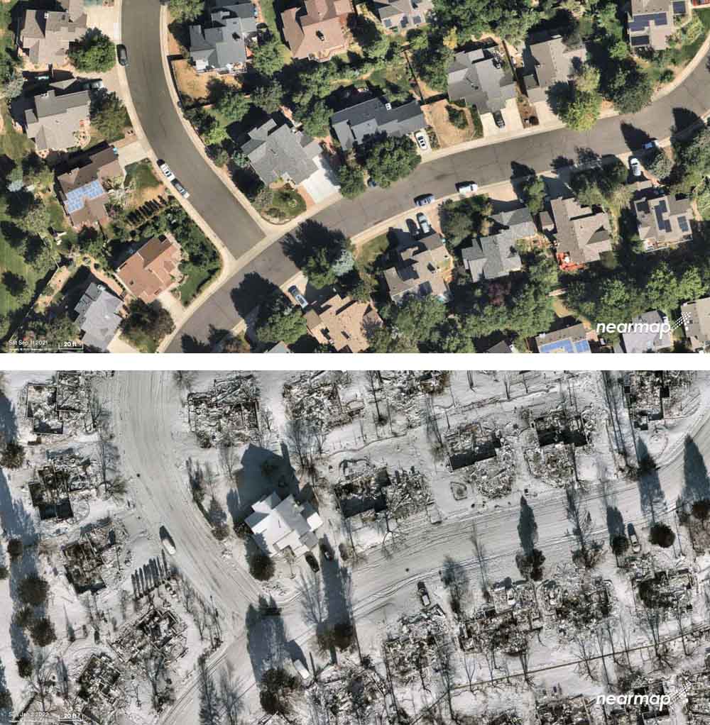
Superior, Colorado, before and after the Marshall Fire, Sept. 11, 2021 and Jan. 2, 2022. Nearmap.
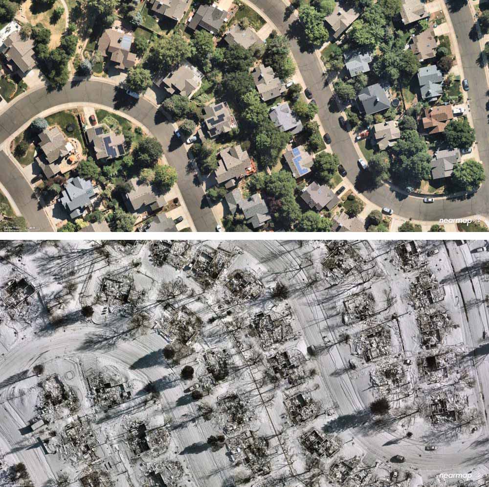
Aerial photos taken of Superior, Colorado before and after the devastating December 30 Marshall Fire show the physical impact on the structures. Most of the homes within the 6,219-acre perimeter were destroyed as the fire was pushed by winds gusting, depending on the location, at 60 to 100 mph while the relative humidity was in the 20s.
Superior, Colorado, before and after the Marshall Fire, Sept. 11, 2021 and Jan. 2, 2022. Nearmap.
At 12 p.m. Wednesday the evacuation order for Louisville was lifted. Superior’s closures were lifted at 6 a.m. Boulder County’s map at 3:30 p.m. Wednesday showed “all clear” and no closures in effect in the fire area.
Investigators have been searching for the two persons still reported as missing at two locations. In the 5900 block of Marshall Road in unincorporated Boulder County they have located partial human remains of an adult. Investigators from both the Sheriff’s Office and Coroner’s Office continue to actively work at this scene.
The search in the 1500 block of S. 76th Street, Superior is ongoing.
There have been no other reports of fatalities tied to the fire.
The Boulder County Sheriff’s office said there are no updates on the continuing investigation into the cause and origin of the Marshall Fire. The weather has been a factor in the speed at which the investigations are able to be conducted.
The Disaster Assistance Center is available for anyone impacted by the fire. It is located at 1755 South Public Road, Lafayette, and is open from 9 a.m. to 7 p.m. every day.
President Joe Biden will be in Boulder County Friday to see the damage caused by the fire.
Below is information from Boulder County about how to help:
We know our community’s heart is huge, and everyone wants to help. Official sites are unable to accept any material donations — please do not bring these to shelters or other disaster support locations.
Victims most need money. While some families have gofundme accounts set up by friends, we cannot verify the authenticity of each of these, and we are concerned about fraud. The very best way to ensure victims receive funding, without tax implications, is to donate to www.coloradogives.org
Can’t give money, but want to volunteer? There will be many needs in the months ahead. Please do not self-dispatch to disaster areas. Please registers at: https://coloradoresponds.communityos.org/. This state clearinghouse will strive to match volunteers with community and individual needs.
Due to the recent fires, BCPH is working to determine the health risk current air quality poses. There are several air monitoring stations in Boulder and Longmont that measure regional air quality which currently report to be moderate to good. Information: https://t.co/prFb56Kfpnpic.twitter.com/6Hbnfh0Q4u
A closer look at the destruction left in the wake of the devastating #MarshallFire. This afternoon we’re speaking with folks trying to get their lives back on track. Those stories on @DenverChannel tonight at 5. pic.twitter.com/vimhURYMty
Before and after aerial imagery of the catastrophic #MarshallFire in Boulder County, Colorado via @gic_org. The imagery of destroyed homes and structures blanketed by snow is unlike anything I’ve seen post-fire. (h/t @ai6yrham) pic.twitter.com/wS8tJdU6ye
A writer says, California’s “honeymoon is over for its residents now that wildfires are almost constant”
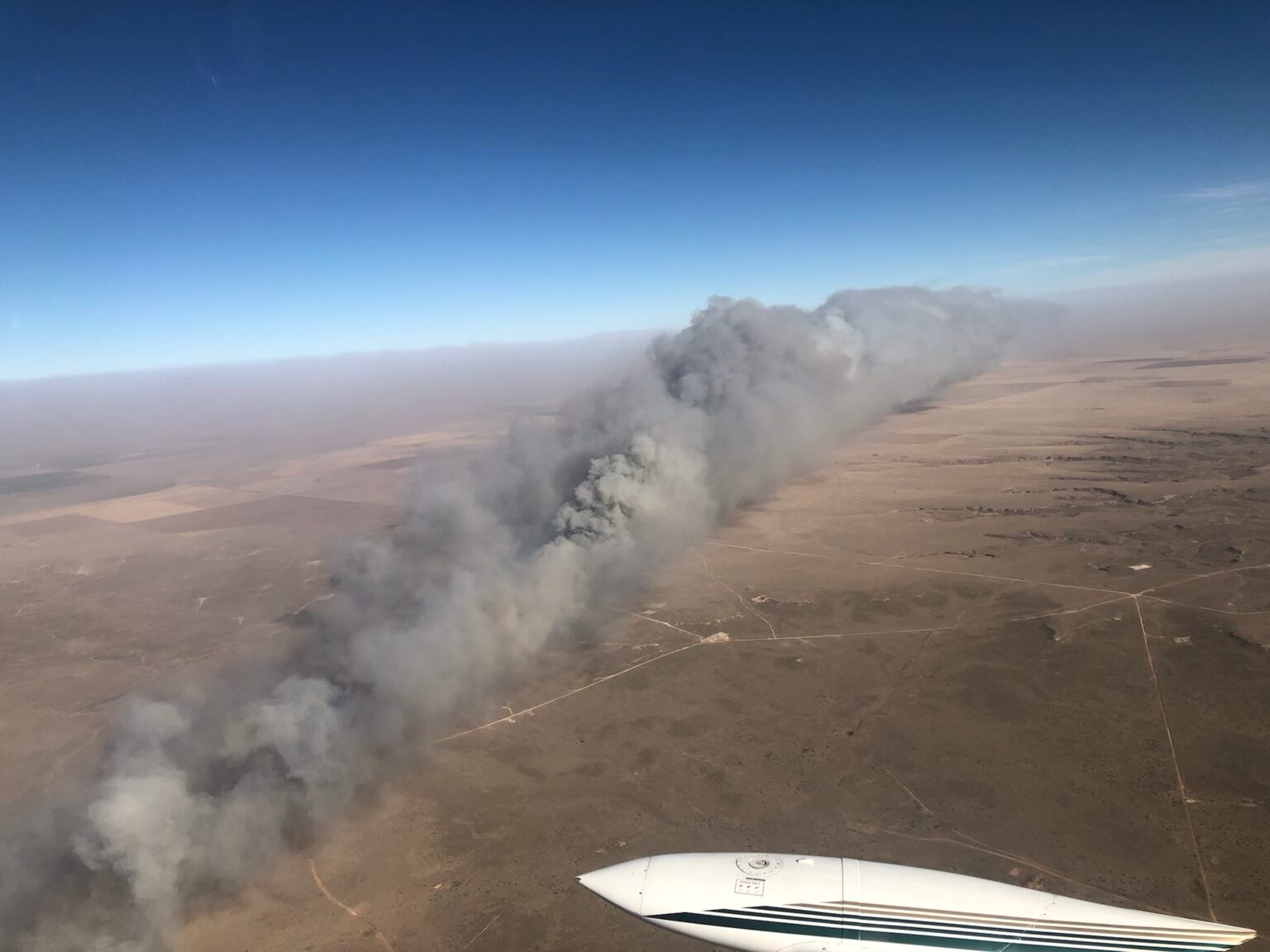
Parker Creek Fire, December 15, 2021. Texas Forest Service photo.
Sunday night as I watched the Season 4 finale of Yellowstone, John Dutton, played by Kevin Costner, was talking with another character who said, “I’m terrified of the world we’re leaving (for my grandchildren). I honestly don’t know what this place will look like in 100 years.”
“Grass will cover the streets, and weeds will cover the rooftops,” Dutton said. “I don’t think we make it 100 years.”
I have been thinking about wildfire smoke recently, and how during the last two years massive plumes of smoke from fires in the western states have often migrated east, sending hazardous air laden with tiny PM2.5 particles (2.5 micrometers and smaller) across a dozen states. I learned in a Smoke Management class that if you could drop a PM2.5 particle from eight feet high in a room with still air, it would take about eight hours for it to reach the floor. Smoke with these pollutants is easily transported hundreds or thousands of miles across state and international boundaries. Canada and the United States seem to take turns exporting PM2.5 across the border.
As the sun begins to set on the west coast, gray smoke from wildfires can be easily distinguished from white clouds. NOAA, GOES 17.
In research published online last week in the journal Toxicological Sciences, researchers reported that inhaled microscopic particles from woodsmoke such as PM2.5 work their way into the bloodstream and reach the brain, and may put people at risk for neurological problems ranging from premature aging and various forms of dementia to depression and even psychosis.
Extreme weather conditions that a few decades ago were rare are occurring more frequently, sometime establishing conditions suitable for extreme fire behavior. If this trend continues to increase, where will we be in 10, 20, or 30 years? Or 100 years? Grass on the streets and weeds on rooftops?
Widespread smoke is just one of the symptoms of how climate change is degrading the quality of life for many people on this planet. In the article described below, the author wrote that a researcher told her that “Wildfire is literally making it unsafe to be pregnant in California.”
The article by Elizabeth Weil published Monday in New York Times Magazine is well worth your time. It is a long form piece looking at how wildfires are changing, and the effects. She examines most of the issues that are involved — weather, climate, prescribed fire, indigenous fire, fuel breaks, “managed” fire, human health, fire resistant construction, and the home ignition zone — in a style that makes you want to keep reading, and hoping that you don’t get to the end of the article in the next paragraph or two.
It is behind a pay wall, but that’s the life we have now, or are moving toward. (Yes, even Wildfire Today has considered a subscription fee.)
Here are excerpts from the article, titled, This Isn’t the California I Married — The honeymoon’s over for its residents now that wildfires are almost constant. Has living in this natural wonderland lost its magic?
…Aching and eager to escape my own boring loop of depressive thoughts, I met with Alex Steffen, a climate futurist, on the back patio of a bar in Berkeley. Steffen, a 53-year-old mountain of a man with a crystal-ball-bald pate, hosts a podcast and publishes a newsletter called “The Snap Forward.” The idea behind both is that the climate crisis has caused us to get lost in time and space; we need to dig ourselves out of nostalgia and face the world as it exists. As he explained to me in his confident baritone, yes, California, and the world, are in bad shape. But the situation is not as devoid of hope as we believe. “We have this idea that the world is either normal and in continuity with what we’ve expected, or it’s the apocalypse, it’s the end of everything — and neither are true,” he said. That orange sky in 2020? “We’re all like, Wow, the sky is apocalyptic! But it’s not apocalyptic. If you can wake up and go to work in the morning, you’re not in an apocalypse, right?”
The more accurate assessment, according to Steffen, is that we’re “trans-apocalyptic.” We’re in the middle of an ongoing crisis, or really a linked series of crises, and we need to learn to be “native to now.” Our lives are going to become — or, really, they already are (the desire to keep talking about the present as the future is intense) — defined by “constant engagement with ecological realities,” floods, dry wells, fires. And there’s no opting out. What does that even mean?
We’re living through a discontinuity. This is Steffen’s core point. “Discontinuity is a moment where the experience and expertise you’ve built up over time cease to work,” he said. “It is extremely stressful, emotionally, to go through a process of understanding the world as we thought it was, is no longer there.” No kidding. “There’s real grief and loss. There’s the shock that comes with recognizing that you are unprepared for what has already happened.”
…
Relinquishing the idea of normal will require strength, levelheadedness, optimism and bravery, the grit to keep clinging to some thin vine of hope as we swing out of the wreckage toward some solid ground that we cannot yet see. “We’re no longer dealing with a fire regime in the woods that responds to the kinds of mild prevention and mild responses, the sensible responses we have thought about, and that thought alone is a crisis,” Steffen said. “It means the lives we had we no longer have.”
…
This brings us to one other forest- management tool in the knife: “managed wildfire.” This one, however, does not always pair well with the other overabundant species out there in California: people.
…
This summer, in Kings Canyon, as the wildfires approached, firefighters wrapped giant sequoias in aluminum foil. This included General Sherman — 2,200 years old and the largest single tree on Earth. This act was meager, and it was devotional. It’s what we’ve got now. The good news is, some of the moves we need to make are easier, more straightforward and more under our control than we imagined, if we’d just allow ourselves to get them done. The bad news is that there is just going to be loss. We’re not used to thinking about the world that way. We’re not used to paying for our mistakes.
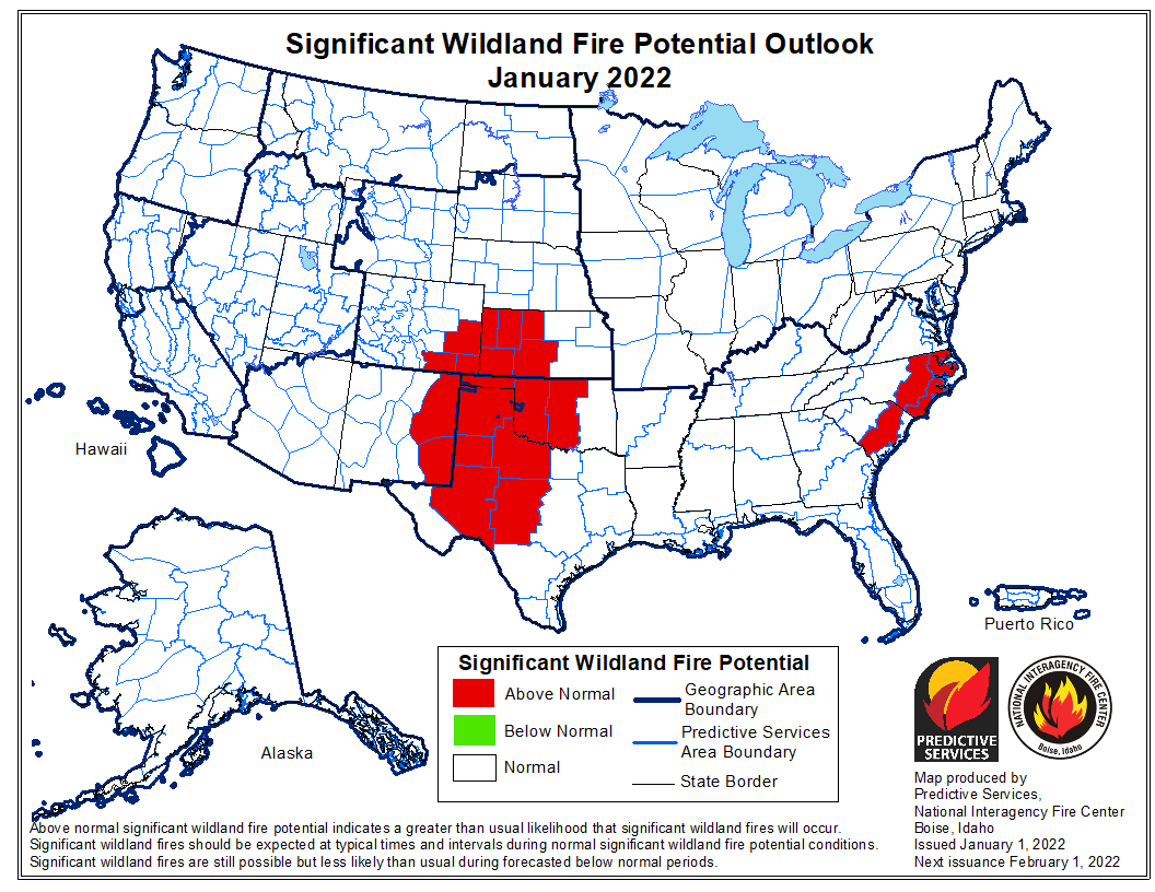
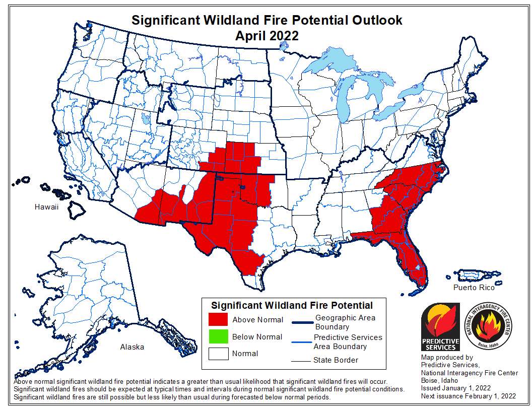
NIFC’s wildfire potential outlook, January through April
The forecast for wildland fire potential issued January 1 by the National Interagency Fire Center predicts that for the next four months the potential for wildfires will be higher than average in the Carolinas, Georgia, Florida, and the central and southern plains.
The data from NIFC shown here represents the cumulative forecasts of the ten Geographic Area Predictive Services Units and the National Predictive Services Unit.
Below:
An excerpt from the NIFC narrative report for the next four months;
Additional NIFC monthly graphical outlooks;
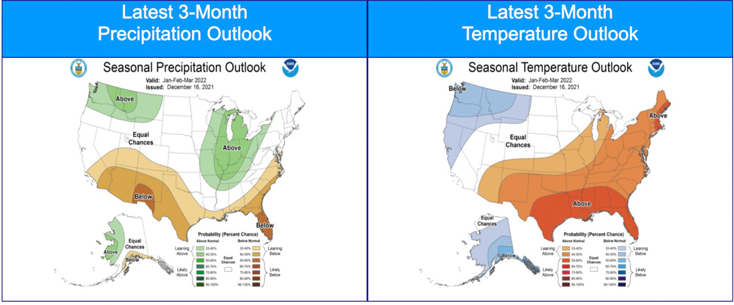
NOAA’s three-month temperature and precipitation forecasts;
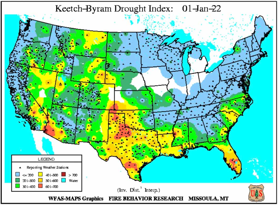
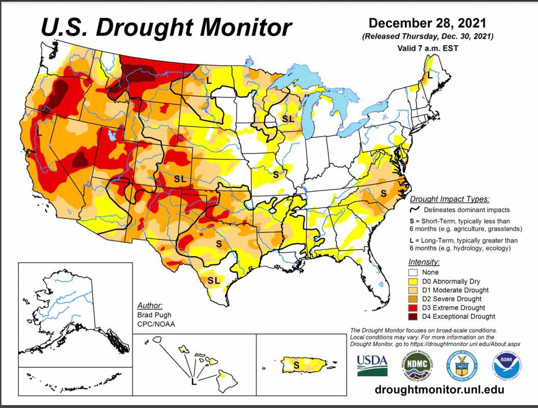
Drought Monitor;
Keetch-Byram Drought Index.
“Nearly 90% of the West remains in drought, with a third of the West in the highest two categories of drought…. Most of the eastern two-thirds of the CONUS observed below normal precipitation with portions of the central and southern Plains receiving no precipitation during December. Above normal precipitation was observed across much of the West into portions of the northern Plains and northern Great Lakes. Temperatures were above normal for most of the CONUS except along portions of the West Coast and Montana. Abnormally dry and drought conditions expanded across the southern Plains due to the prevalence of much above normal temperatures and little to no precipitation in December.
“Climate outlooks for winter into early spring indicate above normal temperatures are likely along the southern tier of the CONUS, with the highest probabilities likely in the South. Below normal temperatures and above normal precipitation are expected across the Pacific Northwest into portions of the northern Rockies and northern Plains. The Great Lakes and Mid-Mississippi Valley are also likely to experience above normal precipitation through March. Below normal precipitation will likely accompany above normal temperatures across the southern third of the western US, through much of Texas, along the Gulf Coast, and into the Carolinas.
“Above normal significant fire potential is forecast for much of the central and southern Plains January through April with several periods of critical conditions possible due to wind events. Above normal potential is forecast to expand into portions of south Texas in February then westward across far West Texas, southern New Mexico, and southeast Arizona March into April.
“Above normal significant fire potential is expected to expand from the eastern Carolinas in January into the remainder of the Carolinas and much of Florida and Georgia February through April. Above normal potential is also forecast for portions of Virginia in February that will expand into eastern West Virginia and the Mid-Atlantic for March.”


 The forecast for wildland fire potential issued January 1 by the National Interagency Fire Center predicts that for the next four months the potential for wildfires will be higher than average in the Carolinas, Georgia, Florida, and the central and southern plains.