Author: Bill Gabbert
Three large fires are active in Northeast Nevada
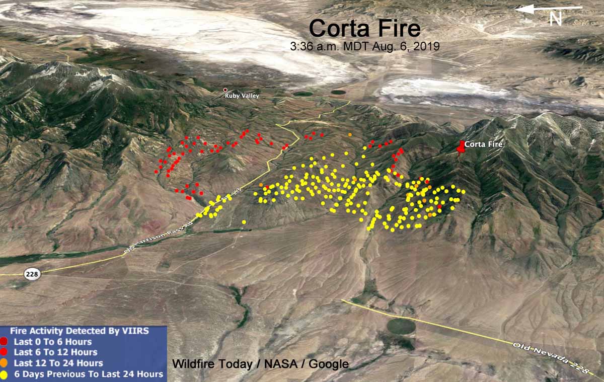
The Corta Fire 6 mile southeast of Jiggs, NV has burned 15,000 acres
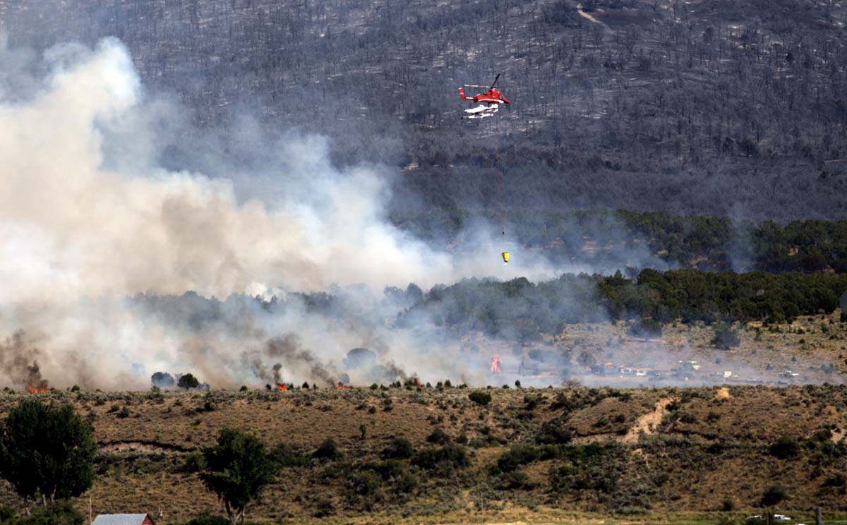
It will not receive much public notice because of the sparsely populated nature of the area, but three large wildfires are burning in Northeast Utah.
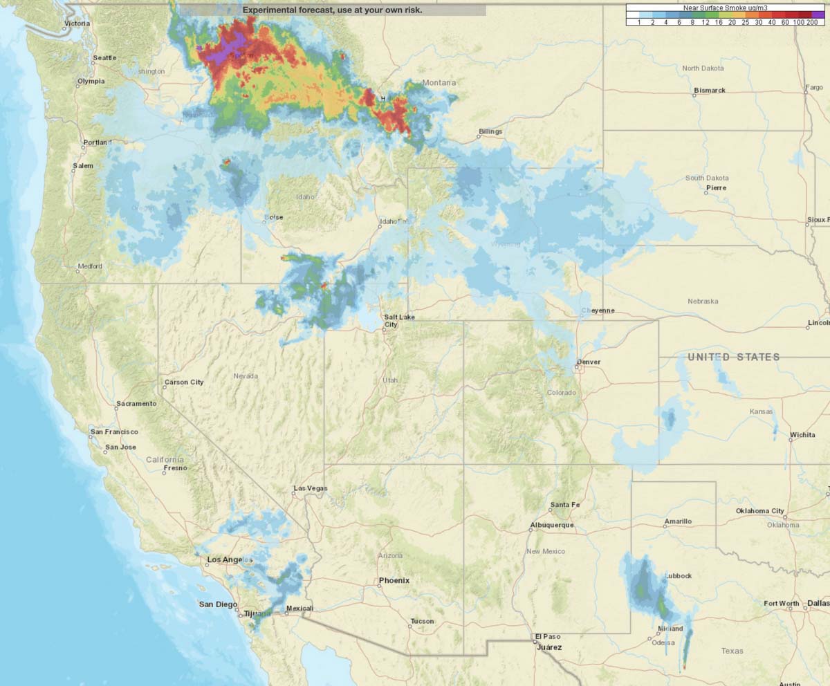
The Great Basin Coordination Center has a clever map with clickable icons that will show live camera views, but often the fires are too far away from the cameras to see much through the limited visibility of the smoky air.
All three of these fires started on August 4, 2019 and share the same strategy of full suppression.
The lightning-caused Corta Fire has been very active. It straddles a major saddle between two very large ridges with grass and brush in the lower elevations at 6,000 feet, but with timber on the north and south sides at 8,000 to 10,000 feet.
The fire is 6 miles Southeast of Jiggs and 3 miles west of Ruby Valley. The last reported size was 15,000 acres.
At 11 a.m. MDT Tuesday it was reported that the fire had jumped the Harrison Pass Road and was making a run to the north. It was tracking directly toward the Green Mountain area which contains critical mule deer winter range, Columbian Spotted Frog habitat, priority Greater Sage-Grouse Habitat, and Lahontan Cutthroat Trout which is listed as a federally threatened species.
The Nevada Type 3 Team 1 will be assuming command of the fire Tuesday. Additional air and ground resources are being ordered and firefighters will continue direct and indirect line construction around the fire perimeter, strengthen and patrol completed lines, and initiate structure protection as needed if fire threatens private ranches. No structures are threatened at this time.
Shafter Fire
Last reported size was 4,300 acres burning in brush 25 air miles west of Wendover, Utah.
Goose (or Little Goose) Fire
Last reported size, 6,698 acres. It is in the northeast corner of Nevada very close to the Idaho border 42 miles southeast of Twin Falls, Idaho. It was very active Monday.

Researchers evaluate connection between California wildfires and human-caused climate change
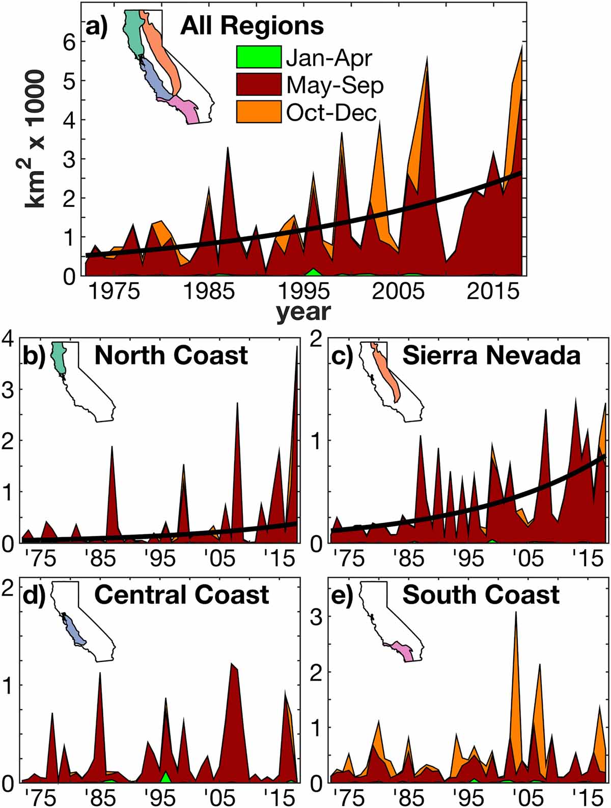
A group of seven scientists published a paper last month that looks at the connection between California wildfires and human-caused climate change, titled Observed Impacts of Anthropogenic Climate Change on Wildfire in California. One of their main conclusions was that climate warming dries the atmosphere which in turn dries fuels, promoting forest fires in the summer.
Here is the abstract:
“Recent fire seasons have fueled intense speculation regarding the effect of anthropogenic climate change on wildfire in western North America and especially in California. During 1972–2018, California experienced a fivefold increase in annual burned area, mainly due to more than an eightfold increase in summer forest‐fire extent. Increased summer forest‐fire area very likely occurred due to increased atmospheric aridity caused by warming. Since the early 1970s, warm‐season days warmed by approximately 1.4 °C as part of a centennial warming trend, significantly increasing the atmospheric vapor pressure deficit (VPD). These trends are consistent with anthropogenic trends simulated by climate models. The response of summer forest‐fire area to VPD is exponential, meaning that warming has grown increasingly impactful.
“Robust interannual relationships between VPD and summer forest‐fire area strongly suggest that nearly all of the increase in summer forest‐fire area during 1972–2018 was driven by increased VPD. Climate change effects on summer wildfire were less evident in nonforested lands. In fall, wind events and delayed onset of winter precipitation are the dominant promoters of wildfire. While these variables did not change much over the past century, background warming and consequent fuel drying is increasingly enhancing the potential for large fall wildfires. Among the many processes important to California’s diverse fire regimes, warming‐driven fuel drying is the clearest link between anthropogenic climate change and increased California wildfire activity to date.”
An illustration from the paper:
Below is an excerpt from the paper:
“In this study we evaluated the various possible links between anthropogenic climate change and observed changes in California wildfire activity across seasons, regions, and land cover types since the early 1970s. The clearest link between California wildfire and anthropogenic climate change thus far has been via warming‐driven increases in atmospheric aridity, which works to dry fuels and promote summer forest fire, particularly in the North Coast and Sierra Nevada regions. Warming has been far less influential on summer wildfire in nonforest areas. In fall, the drivers of wildfire are particularly complex, but warming does appear to enhance the probability of large fall wildfires such as those in 2017 and 2018, and this effect is likely to grow in the coming decades.
“Importantly, the effects of anthropogenic warming on California wildfire thus far have arisen from what may someday be viewed as a relatively small amount of warming. According to climate models, anthropogenic warming since the late 1800s has increased the atmospheric vapor‐pressure deficit by approximately 10%, and this increase is projected to double by the 2060s. Given the exponential response of California burned area to aridity, the influence of anthropogenic warming on wildfire activity over the next few decades will likely be larger than the observed influence thus far where fuel abundance is not limiting.”
Citation:
Observed Impacts of Anthropogenic Climate Change on Wildfire in California.
A. Park Williams John T. Abatzoglou Alexander Gershunov Janin Guzman‐Morales Daniel A. Bishop Jennifer K. Balch Dennis P. Lettenmaier
First published: 15 July 2019 https://doi.org/10.1029/2019EF001210
Goose Fire burning from Nevada toward Idaho
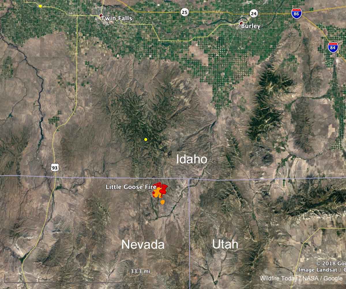
A fire that was reported at 6:23 p.m. Sunday August 4 in the Northeast corner of Nevada has been burning vigorously on Monday. Heat detected by a satellite at 1:36 p.m. (see map above) showed it to be moving north and had spread to within a mile of the Nevada/Idaho border. In later satellite photos it appeared to have approached the border and was generating pyrocumulus clouds. By the time you read this there is a good chance it will have burned into Idaho.
The BLM reported at about 6 p.m. Monday that it was a full suppression fire and had burned 3,500 acres.
At various times it was called “Goose Fire” and “Little Goose Fire”. Just plain “Goose Fire” seemed to be winning out by late Monday afternoon.
As anticipated, fire plumes are becoming evident on satellite this afternoon. This one is the Goose or Little Goose right on the border of Nevada/Idaho. #idfire pic.twitter.com/sjdJICsq3x
— NWS Pocatello (@NWSPocatello) August 5, 2019
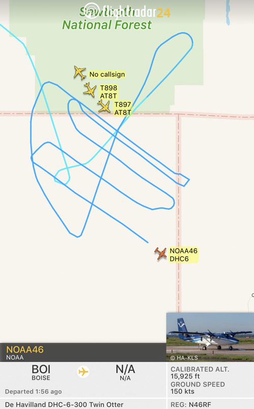
At about 4:40 p.m. MDT FlightRadar showed four single engine air tankers from Twin Falls and Tanker 911, a DC-10 from Pocatello, flying in the vicinity of the Goose Fire. A NOAA research Twin Otter also showed up, flying a grid pattern — NOAA46 (N46RF), that was most likely analyzing the atmosphere over the fire. NOAA has a fleet of nine aircraft that conduct airborne environmental data gathering missions. Later after the first NOAA Twin Otter departed, another NOAA Twin Otter was over the fire, NOAA48.
70 years ago today: Mann Gulch Fire
Thirteen firefighters, most of them smokejumpers, lost their lives on the fire
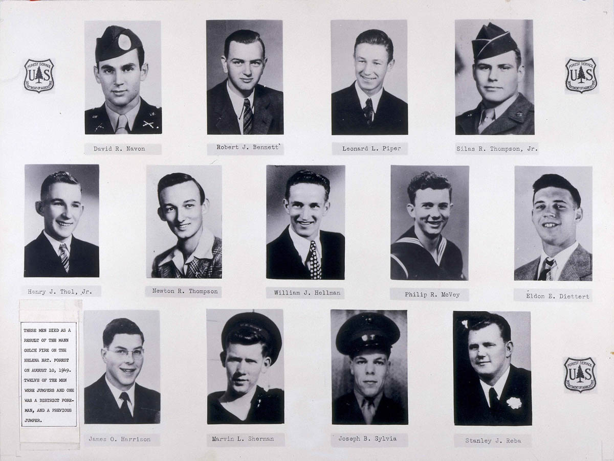
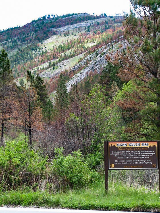
Seventy years ago today on August 5, 1949 a wildfire entrapped 15 smokejumpers and a fire guard in Mann Gulch on the Helena National Forest in Montana. The fire took the lives of 13 men and burned nearly 5,000 acres.
The fatalities on the Mann Gulch Fire
Robert J. Bennett
Eldon E. Diettert
James O. Harrison
William J. Hellman
Philip R. McVey
David R. Navon
Leonard L. Piper
Stanley J. Reba
Marvin L. Sherman
Joseph B. Sylvia
Henry J. Thol, Jr.
Newton R. Thompson
Silas R. Thompson
The story of this fire was told by Norman Maclean in his book “Young Men and Fire”. John’s website has a new page that features a new retrospective on the fire.
The sketch below is from the official report.

The fire occurred near the Missouri River in Western Montana 20 miles north of downtown Helena, and 6 miles north of the North Hills Fire that burned about 5,000 acres a couple of weeks ago. (see map below)

A paper analyzed Smokejumper Foreman Wag Dodge’s escape fire that probably saved his life on the Mann Gulch Fire. In the 27-page document written by Martin E. Alexander, Mark Y. Ackerman, and Gregory J. Baxter, they concluded that the size of Mr. Dodge’s escape fire was about 120 feet by 86 feet when it was overrun by flames from the main fire. Mr. Dodge later told investigators that he explained to the firefighters nearby that after the escape fire spread and cooled in the interior, they should take refuge in the new burned area with him. Unfortunately, none of them did.
The paper includes a statement made by Mr. Dodge that was included in Earl Cooley’s 1984 book, Trimotor and Trail.
When the main fire reached my area, I lay down on the ground on my side and poured water from my canteen on my handkerchief over my mouth and nose and held my face as close to the ground as I could while the flames flashed over me. There were three extreme gusts of hot air that almost lifted me from the ground as the fire passed over me. It was running in the grass and also flashing through the tree tops. By 6:10 p.m. the fire had passed by and I stood up. My clothing had not been scorched and I had no burns.
Here is a photo of Mann Gulch taken in 2008, from The Travels of John and Breya.
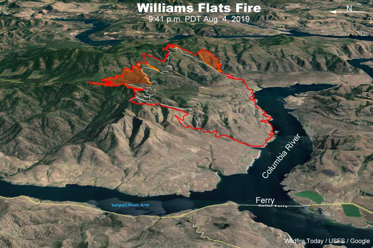
Williams Flats Fire spreads to the east and north
The fire is 15 miles east of Coulee Dam, Washington

(UPDATED at 8:17 a.m. PDT August 6, 2019)
On Monday the Williams Flats Fire in Northeast Washington spread for another half mile to a mile toward the north and east, to bring the total burned area up to 16,781 acres according to data from an overnight fixed wing mapping flight. (see map above)
The fire spread across Whitestone Ridge on the southeast flank. Dozers are constructing direct fireline and crews are burning out fuels as construction progresses toward the fire’s northeast corner. Helicopters were able to drop water as needed Monday to reduce the risks of loss to timber, Hellgate Game Reserve, and archeological sites, but water-scooping planes and large air tankers were unable to fly due to heavy smoke which compromised visibility.
Challenges firefighters are facing on this include high temperatures, reduced visibility, steep rocky terrain, and wildlife dangers such as snakes and bears.
Firefighting resources assigned to the Williams Flats Fire:
- 22 hand crews
- 8 helicopters
- 18 fire engines
- 9 dozers
- 22 water tenders
- 764 total personnel
(Originally published at 1 p.m. PDT August 5, 2019)
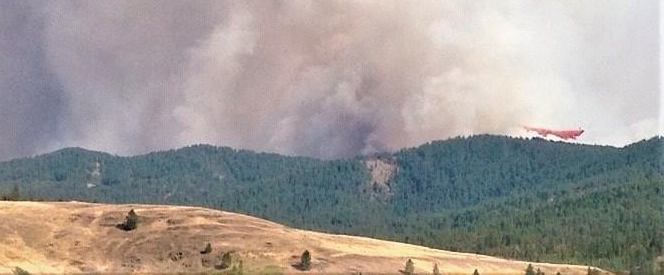
The Williams Flats Fire along the Columbia River 15 miles east of Coulee Dam, Washington spread half a mile to one mile on the north and east sides on Saturday and Sunday to bring the size up to 13,497 acres. (see map below)
The fire is burning on Confederated Tribes of the Colville Reservation and Washington Department of Natural Resources protected lands. On Monday firefighters will strengthen existing containment lines and begin mop-up of hot spots on the west flank. Line construction is on-going on the southeast flank toward Whitestone Ridge. Dozers are constructing direct fireline and crews are burning out fuels as construction progresses toward the fire’s northeast corner.

Firefighting resources assigned to the Williams Flats Fire include 14 hand crews, 18 fire engines, 8 dozers, 19 water tenders, and 7 helicopters for a total of 542 personnel.
Helicopters are dipping and air tankers are scooping water (see above) from nearby Lake Roosevelt to aid on-the-ground firefighters in suppression efforts and the aircraft need space to work. The public is asked to avoid these activities on the water. The area is being patrolled by the the Confederated Tribes of the Colville Reservation Law Enforcement.
Weather
The forecast for Monday calls for 91 degrees, 15 percent relative humidity, and winds out of the southwest and west at 6 mph, with limited humidity recovery Monday night. Tuesday should be the hottest day of the week, with 94 degrees, 14 percent RH, and variable winds at 2 to 7 mph.

