Depends on which charges, if any, are filed by county district attorneys for causing wildfires in 2017 and 2018
In a brief submitted to a federal court, the California Attorney General wrote that Pacific Gas & Electric could be prosecuted for murder, manslaughter or lesser criminal charges if investigators determine that “reckless operation” of its power equipment caused any of the wildfires in which people were killed during the last 15 months.
A dozen of the fires that started in Northern California around October 8, 2017 have been blamed on PG&E’s electrical equipment, according to CAL FIRE Investigators, who also are looking into power line equipment failures that may have caused the Camp Fire on November 8, 2018. Over 40 people died in the Northern California fires, and 86 perished in the Camp Fire. More than 14,000 homes were destroyed in the Camp Fire.
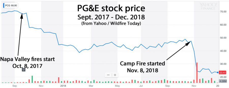
Shortly after both events the stock price of PG&E dropped precipitously, sinking 66 percent over the 13-month period. It took several days in 2017 for word to spread that the company appeared to be liable for the Northern California fires, but the sell-off began the day after the Camp Fire started in 2018. Investors are worried that the utility could be on the hook for billions of dollars in civil damages in addition to criminal penalties.
Below is an excerpt from the Sacramento Bee:
The legal brief submitted by [Attorney General Xavier] Becerra’s office said prosecutors would have to gauge PG&E’s “mental state” before determining which charges, if any, to bring. The charges would range from murder to a misdemeanor negligence charge, according to the brief. Becerra’s brief is purely advisory; if any criminal charges are filed, they would likely be lodged by county district attorneys, not the state. So far, though, district attorneys have shown little appetite for prosecuting PG&E, according to Sacramento Bee reporting. No charges have been filed yet in the wine country fires. And at least one DA has opted for a financial settlement in lieu of criminal prosecution
The 54,000-acre fire became the third largest in the recorded history of South Dakota
Legion Lake Fire December 12, 2017. Photo by Bill Gabbert.
A telephone company that is being sued by landowners for allegedly causing the Legion Lake Fire claims the 54,000-acre fire was caused by an “act of God”.
There is no question that a tree falling on a Black Hills Energy power line created sparks which ignited the fire December 11, 2017 in Custer State Park in the Black Hills of South Dakota. Three families claim in the lawsuit that Mt. Rushmore Telephone Company weakened the root system of the Ponderosa pine by digging a utility trench, making it less resistant to strong winds which were present when the fire started.
Below are excerpts from an article in the Rapid City Journal:
In its response, attorneys for Black Hills Energy deny almost everything in the pleading documents, save that a tree fell on a company power line. BHE contests their liability and suggests the plaintiffs themselves should be viewed as equally if not more guilty for their damage in the Legion Lake Fire. “Plaintiffs failed to mitigate their damages,” attorneys for Black Hills Energy write, “and any damages resulting from Plaintiffs’ failure to mitigate their damages may not be recovered.” Mt. Rushmore Telephone Company’s response is even shorter, arguing the Legion Lake Fire was “the result of an act of God.”
The 10,000 acres of private land that burned in the fire is used for raising cattle and many land owners lost pastures, fences, and winter hay.
More than half of the portion of Custer State Park that was available for their bison herd burned, and park officials asked for hay donations to help the animals get through the winter. Over 8,000 acres of Wind Cave National Park also burned in the Legion Lake Fire and in the earlier Rankin Fire, but park spokesperson Tom Farrell said they still had plenty of forage in reserve for the 260 elk and 350 bison.
Legion Lake Fire, December 13, 2018. Photo by Bill Gabbert.
Jurisdictions need to develop standards for structures, the home ignition zone, and community infrastructure
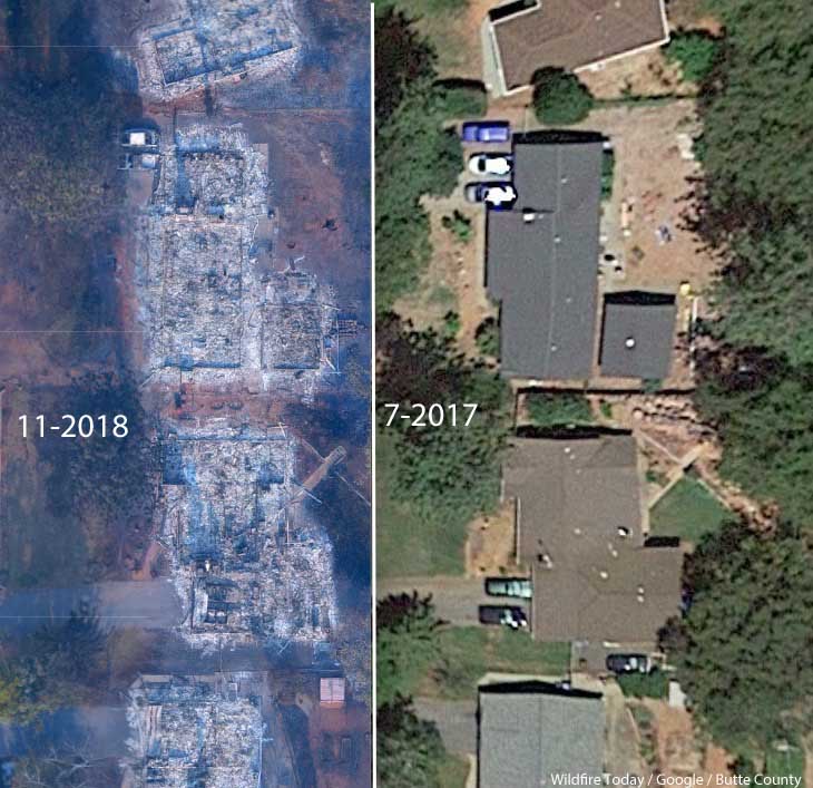
A neighborhood on Debbie Lane in Paradise, California, before and after the Camp Fire that started November 8, 2018. The homes were 14 to 18 feet apart.
In the weeks after 86 people were killed and over 14,000 homes and businesses were destroyed in the Camp Fire at Paradise, California three influential individuals and organizations urged the consideration of banning or restricting development in areas that are at high risk from wildfires.
First there was the Los Angeles Times Editorial Board on November 24 writing that “To rebuild Paradise as it was, would be land-use malpractice.” The Board continued, “The question facing state and local authorities is whether Paradise — and other towns that have burned — can be rebuilt to withstand the next, inevitable wildfire. If not, how does California relocate communities and restrict new construction while respecting property rights and not worsening the state’s affordable housing crisis? At a minimum, cities should remap fire-prone areas and focus reconstruction in areas with lower risk. “
Then on December 10 the group 1000 Friends of Oregon released “A New Vision for Wildfire Planning” that recommended avoiding development in high risk areas.
Chief Ken Pimlott, March 22, 2016. Photo by Bill Gabbert.
Five days before he retired on December 15 Ken Pimlott, Director of the California Department of Forestry and Fire Protection, was quoted by the Associated Press as saying officials should consider banning home construction in areas vulnerable to wildfires.
Cities, counties, and planning boards (where they exist) are often under pressure to approve new housing developments. They want to expand their tax base. Developers try to fit as many homes into a new subdivision as possible to maximize their investment. This too often results in homes that are 20-feet apart. If one is ignited by a burning ember that may have traveled a quarter of a mile from a fire (or a burning home) the radiant heat alone can ignite the homes on both sides. Then you can have a self-powered conflagration spreading house to house through a city. As long as the structures are that close together, the homeowners have not reduced the fuel in the Home Ignition Zone within 100 feet of the structure, and the home itself is not built to FireWise standards, a massive disaster can be the result.
The NFPA and the FireWise program recommend reducing flammable material within 100 feet of structures, and spacing trees at least 18 feet apart that are within 30 feet of the home. At the 60 to 100-foot distance tree canopies should be at least 6 feet apart. Another house that is 15 to 50 feet away is also fuel and if it ignites will be a serious threat.
If a homeowner wants, or is required, to reduce the flammable material within 100 feet of their residence, what are they expected to do if there is another home 20 feet away that is really a large assembly of flammable material?
Some of the homes in Paradise, California that burned were less than 20 feet apart. According to measurements using Google Earth, the structures in the photo at the top of this article were 14 to 18 feet from each other.
Photo: Anchor Point Group, Boulder, CO
The National Institute of Standards and Technology released a report on the Waldo Canyon Fire that burned 344 homes and killed two people in Colorado Springs, Colorado in June, 2012. They concluded that current concepts of defensible space did not account for hazards of burning primary structures, hazards presented by embers, and the hazards outside of the home ignition zone. In addition, NIST recommended:
High-density structure-to-structure spacing in a community should be identified and considered in [Wildland Urban Interface] fire response plans. In the Waldo Canyon fire, the majority of homes destroyed were ignited by fire and embers coming from other nearby residences already on fire. Based on this observation, the researchers concluded that structure spatial arrangements in a community must be a major consideration when planning for WUI fires.
After studying the Carr Fire that destroyed 1,079 residences at Redding, California earlier this year, retired CAL FIRE Battalion Chief Royal Burnett reached similar conclusions.
It was easy to figure out why the houses on the rim burned — they were looking right down the barrel of a blowtorch. Even though they had fire resistant construction, many had loaded their patios with flammable lawn furniture, tiki bars and flammable ornamental plants. Palm trees became flaming pillars, shredded bark became the fuse, junipers became napalm bombs. Under current standards houses are build 6 to an acre; 10 feet to the property line and only 20 feet between houses. Once one house ignited, radiant heat could easily torch the next one.
We have to learn to live with fire
Reducing the chances that a fire in a populated area will turn into a disaster that burns thousands of homes involves at least three categories of factors, in addition to weather:
Envelope of the structure itself: characteristics of the roof, vents, siding, doors, windows, foundation, fences, eaves, and decks. A FEMA publication (13 MB) has excellent detailed recommendations. Headwaters Economics found that the cost of building a fire-resistant home is about the same as a standard home.
Home Ignition Zone, as described above — topography and fuel within 100 feet.
Community infrastructure and planning: distance to nearby structures, evacuation capability, safety zones, road and driveway width, turnarounds at the end of roads, signage, and emergency water supply. Again, the FEMA document has great recommendations.
Someone asked me recently what needs to be done to keep from repeating disasters like we have seen within the last year at Paradise, Redding, and the Napa Valley. I told him that there is no one thing that needs to be done, such as raking or “forest management”, it requires a comprehensive holistic approach.
The items we have listed here only apply within communities. There is of course much that can be done surrounding the places where people live that would reduce the vegetation or fuel and decrease the intensity and ember generation potential of a fire as it approaches an urban area. Large scale fuel management including fuel breaks and prescribed fire programs are usually conducted by state and federal agencies.
The weakest link in the chain principle applies here. If one of these categories is sub-par, the individual structures and the entire community in a fire-prone environment is at risk. And if a homeowner does not do their part, it can endanger their neighbors.
The warming climate is demonstrating that wildfires are becoming increasingly perilous. It is unlikely that local governments or states are going to ban development in fire-prone environments, but it is their responsibility to protect their citizens by enacting sensible standards.
Imagery from GOES 16 showed dramatic smoke plumes from the Camp Fire
Screenshot from the GOES 16 time-lapse of the Camp Fire.
The NASA article below lays out how the agency believes the imagery from recently launched satellites can assist in the detection and management of wildfires.
GOES-16, operating as NOAA’s GOES East satellite, is proving to be an invaluable asset in detecting wildfires and helping forecasters provide proactive tactical decision-support services. The satellite’s main instrument, the Advanced Baseline Imager (ABI), offers three times more spectral channels, four times increased resolution, and five times faster coverage than the previous GOES imager. This means a much more detailed look at fire conditions, faster detection of hot spots, and the ability to track fire progression and spread in real time.
National Weather Service (NWS) incident meteorologists (IMETs) are using GOES-16 data to assist firefighting efforts. IMETs who deploy to wildfires are instrumental to the mission. An IMET’s first priority is to keep firefighters and the public safe amid rapidly changing wildfire conditions. During the peak of the Camp Fire in northern California in November 2018, the fire was advancing at a rate of over 100 football fields every minute. A shift in the winds could easily put firefighters in danger.
GOES East captured imagery of the Camp Fire in northern California on November 8, 2018. The wildfire developed in the early morning hours and spread quickly within very windy and dry weather conditions. Hot spots and a large plume of smoke are seen in this fire temperature RGB (red-green-blue) imagery is created with Advanced Baseline Imager bands 7, 6, and 5 (shortwave and near infrared bands), which are used to detect hot spots. To make this animation, the fire temperature imagery is made partially transparent and placed over a GeoColor enhancement, so both the fire’s hot spots and smoke plume are visible.
Timely satellite imagery is critical, life-saving information in a dynamic fire environment. In the past, IMETs had a single low-resolution image that updated every 15 minutes – typically the image was already 20 minutes old when it arrived to the forecaster. Now, GOES-16 frequently detects fires before they are spotted on the ground – often 10 to 15 minutes before emergency notifications to 911.
Alex Hoon, the NWS IMET for both the Camp and Carr Fires in California in 2018, says GOES-16 is crucial to an IMET’s mission to protect lives and property. “Now, forecasters are able to get incredible high-resolution images of the fire every single minute in the field, directly supporting firefighters who are engaged in the fire. Not only is this helping firefighters to more effectively fight fire, but more importantly, it’s helping to keep firefighters safe so that they can also come home to their families,” said Hoon.
GOES-16 is also used to pinpoint the exact location of a fire after reports of smoke. On July 2, 2018, the Pueblo County, Colorado, Emergency Management Office called the NWS Pueblo Weather Forecast Office (WFO) for assistance locating the source of smoke reported near Custer/Fremont/Pueblo County lines. GOES-16 showed a hotspot in northeast Custer County and the Pueblo WFO was able to provide the exact coordinates of what would become the Adobe Fire. Being in a remote and wooded area, the early and more precise geolocation of the fire was helpful for getting crews on the scene quickly.
GOES-16 observations are not just valuable for detecting wildfires but are also critical to observing and monitoring smoke from those fires. GOES-16’s ability to monitor smoke plumes in near-real time is particularly useful in directing firefighting efforts from the air. Deploying airplanes and helicopters to spray fire retardant is often hampered due to poor visibility. GOES-16 can help guide decisions for deploying flights by providing information on the exact location and motion of smoke from a fire. The smoke detection and monitoring information also enable better air quality forecasts.
The benefits from GOES-16 aren’t just seen during a fire but are also important in monitoring burn scars and predicting flash flood events from rain events after a fire. GOES-16 provides critical data for the entire lifecycle of a fire disaster – from drought to fire to floods and landslides.
The new capabilities from GOES-16 are a game-changer for fire weather forecasts and warnings. Soon, GOES-16 will be joined by its twin satellite, GOES-17, as NOAA’s operational GOES West. GOES-17 will provide even better resolution for U.S. West Coast firefighting efforts than GOES-16 due to its location over the Pacific Ocean.
New channels on the ABI provide more information to forecasters and the high resolution and rapid scanning give them high-definition images as often as every minute. Data from the ABI is helping forecasters locate hotspots, detect changes in a fire’s behavior, predict a fire’s motion, and monitor the post-fire landscape like never before. Providing this information to firefighters, emergency managers, and state and county agencies helps NOAA’s Satellite and Information Service meet its mission of protecting the nation’s environment, security, economy and quality of life.
The research will be supported by a $1.5 million award.
University of Maryland (UMD) Associate Professor Michael Gollner will co-lead a first-of-its-kind research effort to quantify the pulmonary and cardiovascular health consequences to firefighters exposed to wildland fire smoke. The research is supported by a $1.5 million award from the Assistance to Firefighters Grant Program administered through the Federal Emergency Management Agency (FEMA), a Department of Homeland Security agency.
The smoke of wildland fires—such as California’s Mendocino Complex of Fires, which burned 459,123 acres, destroyed 280 structures (including 157 residences), and killed a firefighter during the 2018 wildfire season—contains particulate matter, carbon monoxide, volatile organic carbon compounds, and other toxic hazards that could put firefighters at risk for chronic illnesses such as ischemic heart disease, cardiovascular disease, and chronic obstructive pulmonary disease (such as emphysema and chronic bronchitis).
Members of a hotshot crew work in smoke on the Cold Brook Prescribed Fire, October 23, 2014. Photo by Bill Gabbert.
But unlike structural firefighters who have relatively well-defined respiratory personal protective equipment standards for fighting fires in and near buildings, wildland firefighters have no standards or requirements for prescriptive respiratory protection. And because wildland firefighters are often deployed to a fire for weeks at a time with sometimes repeated deployments for several months over a summer, they experience an exposure pattern with unknown health risks.
“We put wildland firefighters in harm’s way to protect the natural environment, homes and property, and lives. The focus on firefighter safety has largely been about physical injuries such as burns—but as you can imagine, these firefighters are also exposed to a great deal of smoke,” explains Gollner, a fire protection engineer in UMD’s A. James Clark School of Engineering. “We know there can be health consequences to this, but we have no data on the long-term effect of wildland fire emissions on the heart, blood vessels, and lungs of front-line wildfire responders, because it’s incredibly difficult to study.”
The FEMA-funded research will look at different smoke exposures that mimic both smaller prescribed fires (i.e., planned fires that are used to meet management objectives and that consider the safety of the public, weather, and probability of meeting burn objectives) and larger wildfires—as well as the benefit provided by different types of simple respiratory personal protective equipment.
The research team, led by principal investigators and bioengineers Jessica Oakes and Chiara Bellini of Northeastern University, hopes the three-year project will inform which fire scenarios are the most dangerous with greatest risk to firefighters’ pulmonary and cardiovascular health. Perhaps most importantly, it could lead to recommendations for respiratory personal protective equipment that is easily implemented in the field and/or possible changes in tactics to mitigate exposure, with the goal of preserving firefighters’ long-term health.
“Unlike structural firefighters, who will put on an air-purifying respirator or a self-contained breathing apparatus when they enter a building, wildland firefighters typically cover their face with only a simple bandana,” says Gollner. “Bandanas are a common tactic because they don’t add an additional burden of weight to firefighters’ already strenuous activity. However, it is unknown if, or to what extent, this provides health benefits.”
The research team will combine their expertise to solve this challenging problem: Gollner will contribute novel expertise in firefighting practices and fire generation, while Oakes and Bellini will offer interdisciplinary bioengineering expertise that’s critical to understanding this complex health problem. They will also work with the International Association of Fire Fighters and National Fire Protection Association to facilitate input from stakeholder partners including firefighters from several departments across the country, fire organization representatives, health researchers, governmental agencies, and members of technical committees overseeing personal protective equipment standards.
In looking through the 2018 edition of Hotshot Crew History in America, I was interested in a piece in the Historical Articles section. It was written by the Stanley Stevenson, the Fire Control Officer on the Cleveland National Forest in Southern California, possibly around 1950. It appears that Mr. Stevenson had an appreciation for the abilities of hotshot crews. I believe he was later promoted to Forest Supervisor.
“HOT SHOT” Crews
Stanley Stevenson
Fire Control Officer, Cleveland National Forest
Scouting revealed that the head of the Burma Fire of 1949, Cleveland National Forest, was spreading rapidly uphill through medium to heavy brush and would reach the rim of an adjacent watershed unless checked on a small ridge ¼ from the top. One “hot shot” crew under Foreman George McLarty, San Bernardino National Forest, had been working the northern flank from the bottom and would reach the top too late to effect the check. The Cleveland “hot shot” crew Foreman Leon Ballou, and 4 men were flown via helicopter from the southern flank of the fire to the ridge at the head of the fire. The 5 men hurriedly cut a line in front of the fire, back-fired it out and started a direct attack on the fire edge down the south flank to meet the rest of the crew. The crew on the northern flank meanwhile had pushed through and tied to the northern end of the fired out line. Although numerous spots occurred and the crews lost the south flank twice because of whirlwinds, they closed the gap and effected control on a 280-acre fire that would probably have more than tripled its size within 4 hours unless the check had been made and the lines tied together.
Since these crews are trained to subsist on the line with bare essentials, a sustained push taking advantage of lulls in fire intensity is possible. This was demonstrated by the San Bernardino “hot shot” crew on the Agua Tibia Fire of 1950.
Lightning started this fire in very steep to precipitous terrain covered with medium to extremely heavy brush and scrub oak. The west flank of the fire had slopped over the planned control ridge approximately ½ mile from the top of the main divide. Helicopter scouting at 10:30 a.m. revealed that if the slop-over could be controlled the lines being constructed from the top and bottom along the flank would probably control that side of the fire.
Foreman McLarty was flown by helicopter around the slop-over and he then jumped about 6 feet to the ground inside the burn above the slop-over. He subsequently cleared a landing spot and 4 additional men were flown in to begin work on the line. Meanwhile, the rest of the crew were started down the ridge top along an old trail. Helicopter coverage guided the crew to their destination where they split forces and started around the slop-over. Although this action was completed within 1 ½ hours after the initial scouting, the slop-over had spread to a perimeter of approximately 65 chains on a very steep rocky slope in medium to heavy brush oak type.
McLarty and his whole crew worked until dark. They were sent food, lights, and blankets by helicopter. The crew was fed and rested in relays until a “scratch” line was constructed around the slop-over about 11:00 p.m. Early the following morning, the crew was again serviced by helicopter and the fire line finished and mop-up started.
Stubborn aggressiveness on the part of this crew prevented the fire from crossing the drainage and establishing a new head on even more precipitous terrain.
These two examples illustrate the flexibility of “hot shot” crew action. Similar action has been taken many times during the past 4 years. Control possibilities such as these would have been impractical without well organized, trained, and conditioned crews.
One of the “hot shot” crews has been based during the fire season on the Cleveland National Forest. The following notes, although concerned primarily with the Cleveland “hot shot” organization and operational procedures, are representative for “hot shot” crews in the California Region.
The crew is composed of young men whose primary requisites are physical fitness and a will to work. Their lack of experience and conditioning are compensated by intensive training in fire line construction and use of hand tools and fire hose lays at the beginning of each season. These men are termed “fire fighters” and receive fire-fighter rates of pay while on a fire. When not engaged on fire suppression they are paid laborer wages and used on forest projects.
A sub-foreman or straw boss works with and has charge of from 5 to 8 fire fighters. The straw boss is an integral part of each crew and takes his days off at the same time as the crew. Two assistant foremen acts as crew bosses and are each assigned one-half the straw boss squads. One of the crew bosses is capable of assuming temporary charge of the whole crew during the absence of the foreman.
The crew is under the direct supervision of an experienced fire fighter who can act, as one foreman put it, “from general to father confessor.” This foreman must be a skilled leader, fire-wise, and physically fit for very arduous work. He usually assumes the duties of sector boss on fires.
Crew members are hired only after full understanding and acceptance of the rigid rules set up. Camp routine is fashioned after that of athletic training camps with scheduled hours for meals, work, recreation and sleep. Although some men quickly drop out of the crew because of the difficulty of the job and the rigid discipline, three have returned each year since 1947 and ten others including the foreman have been on the crew for the past 2 seasons.
Conservation, wildlife, general forestry, and training films give the reasons for the “why” and “how” of forest fire protection. The crew is given instruction in the use and care of fire line hand tools, followed by intensive work-outs on practice fire lines. Several afternoons during the first part of the season are spent on illustrative lectures, orientation, fire behavior, safety, and correct fire line construction practices. Action on early season fires is discussed on the ground with a large part of the constructive comment coming from the crew members.
After several successful attacks on early season fires, crews begin to develop an esprit de corps and an eagerness to prove their ability. Several distinctive arm patches have been designed and worn by crews hailing their identity. The competitive spirit on large fires requiring more than one crew has provided additional incentive toward better production.
The following summary of work accomplishment, although reflecting considerable more suppression time during the heavier fire season of 1950, indicates the advisability of preplanning and budgeting forces primarily for fire suppression.
The value of a trained unit of men that can be sent into difficult sections of a fire perimeter with a high degree of certainty that control will be effected, has been demonstrated many times during the past. The ever increasing demand for “hot shots” when the going gets rough is the fire manager’s endorsement of the “hot shot” program.