
How it was done on the Connell Ridge Fire in British Columbia
Continue readingInterview with Abbie Crews, pilot of CAL FIRE air tankers
One of the very few female air tanker pilots
Continue readingFire Traffic Area, August 20, 2022
 Helicopter entering the convention hall at HAI Heli-Expo in Dallas, March 4, 2022. Eurocopter EC 225 LP, N561AC. HAI photo.
Today we are continuing an occasional weekend feature called Fire Traffic Area. This post serves as the beginning of an open thread where readers can leave comments about issues not yet covered — or maybe they have been covered. This is literally an off-topic thread. What do you think needs to be pointed out, asked, or discussed within the fire aviation community? You have the floor.
The usual rules about commenting apply. And remember, no personal attacks or politics, please.
Firefighter killed by falling tree in Oregon
On the Rum Creek Fire north of Galice, OR
Continue readingUS Forest Service acquires two new King Air 260 aircraft for mapping fires
 New King Air 260 delivered to the US Forest Service, August, 2022. Textron photo.
Two new aircraft have been delivered to the US Forest Service for mapping wildland fires. The Beechcraft King Air 260 can cruise at 356 mph at 35,000 feet, can take off in 2,111 feet, and has a maximum range of 1,980 miles.
The aircraft have the latest infrared (IR) sensing technology, the Overwatch Imaging TK-9 Earthwatch Airborne Sensor, along with legacy U.S. Forest Service sensors, that can accurately map wildfires, even at night and through smoke. The system can perform high-resolution scans of fires in a range of spectrums including thermal and infrared from 2,000 to 20,000 feet in altitude.
The TK-9’s speed of data delivery and automation of mapping processes will make it possible for the Forest Service to quickly release imagery to the public, if they desire. We are checking, but it may be possible for the system to live-stream video.
 Images of the same fire produced by Overwatch Imaging’s TK-9 payload, featuring SWIRNI, Visual, MWIR, and LWIR sensor technology. Overwatch Imaging photo.
The two Citation V aircraft that Coulson Aviation configured and sold to New South Wales in 2021 to serve as lead/intelligence planes were outfitted with the TK-9 Earthwatch multispectral imaging systems.
 Overwatch Imaging TK-9 Multispectral Imaging payload.
“It took roughly 90 minutes to produce aerial fire images under the old process, once we had planned the flight path, sourced approval, undertaken the flight, scanned the fire, downloaded the imagery, and entered it into our mapping systems,” said New South Wales Rural Fire Service Chief Superintendent Christopher Ryder. “Now with the Citations and the TK-9 scanning technology, that process will take more like 30 minutes. The new system will take much of the human intervention out of the scanning and mapping process and provide a better and more timely understanding of where the fire is for the public.”
Previous Forest Service IR mapping aircraft
For decades the US Forest Service has usually operated two infrared mapping planes — a variety of twin-engine King Airs and for a while a Cessna Citation Bravo jet. The Citation suffered a serious avionics issue in June, 2019 and was not used the rest of that year or in 2020. We are unsure if it was ever used again to map fires. The FS filled the gap with privately owned aircraft on exclusive use and call when needed contracts.
Currently the FS is using the agency-owned King Air 200, N149Z, manufactured in 1985 and a King Air B300 owned by Tenax Air Logistics, N350SM.
 US Forest Service infrared plane, N149Z, at Boise, July 19, 2014
We contacted the Forest Service to get an update on the infrared fleet, but they were not able to immediately answer our questions.
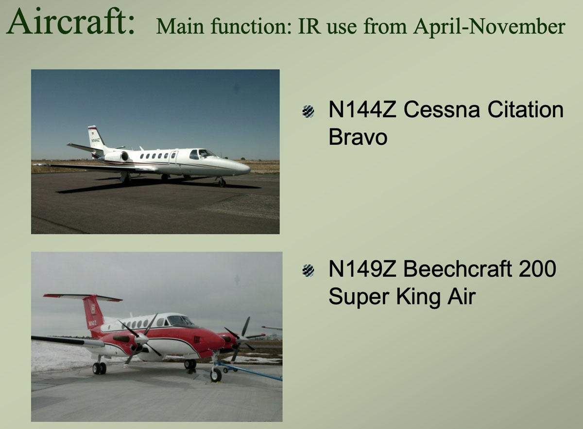 The two USFS aircraft equipped with infrared sensors used to map vegetation fires. USFS graphic from ~2020.
Thanks and a tip of the hat go out to Tom.
Dozens killed in Algeria wildfires
2:26 p.m. EDT August 18 2022
 The red dots on the map represent heat detected on wildfires in Algeria. Satellite photo, August 17, 2022. The fires were creating a great deal of smoke when the photo was taken.
Wildfires in Northeast Algeria have killed at least 38 people according to reports by local journalists and the fire service. Most of the fatalities have occurred in the El Tarf province near Algeria’s border with Tunisia within about 20 miles of the Mediterranean Sea.
Officials said that 39 fires were spreading through parts of northern Algeria, and they warned that hot, dry winds could worsen the situation. Approximately 16 fires are near the city of El Tarf.
At least 26 killed and dozens injured in forest fires that devastated Algeria’s, El Tarf, near Tunisia border. Interior minister Kamel Beldjoud said firefighters, supported by helicopters, were trying to contain several blazes on August 17 evening. With 350 residents evacuated. pic.twitter.com/Q9ucxtP39C
— Lolwe Tv Kenya (@LolweTv) August 18, 2022
About 90 people are thought to have died in fires last year when more than 250,000 acres of forests burned.
Mapping wildfires from 70,000 feet
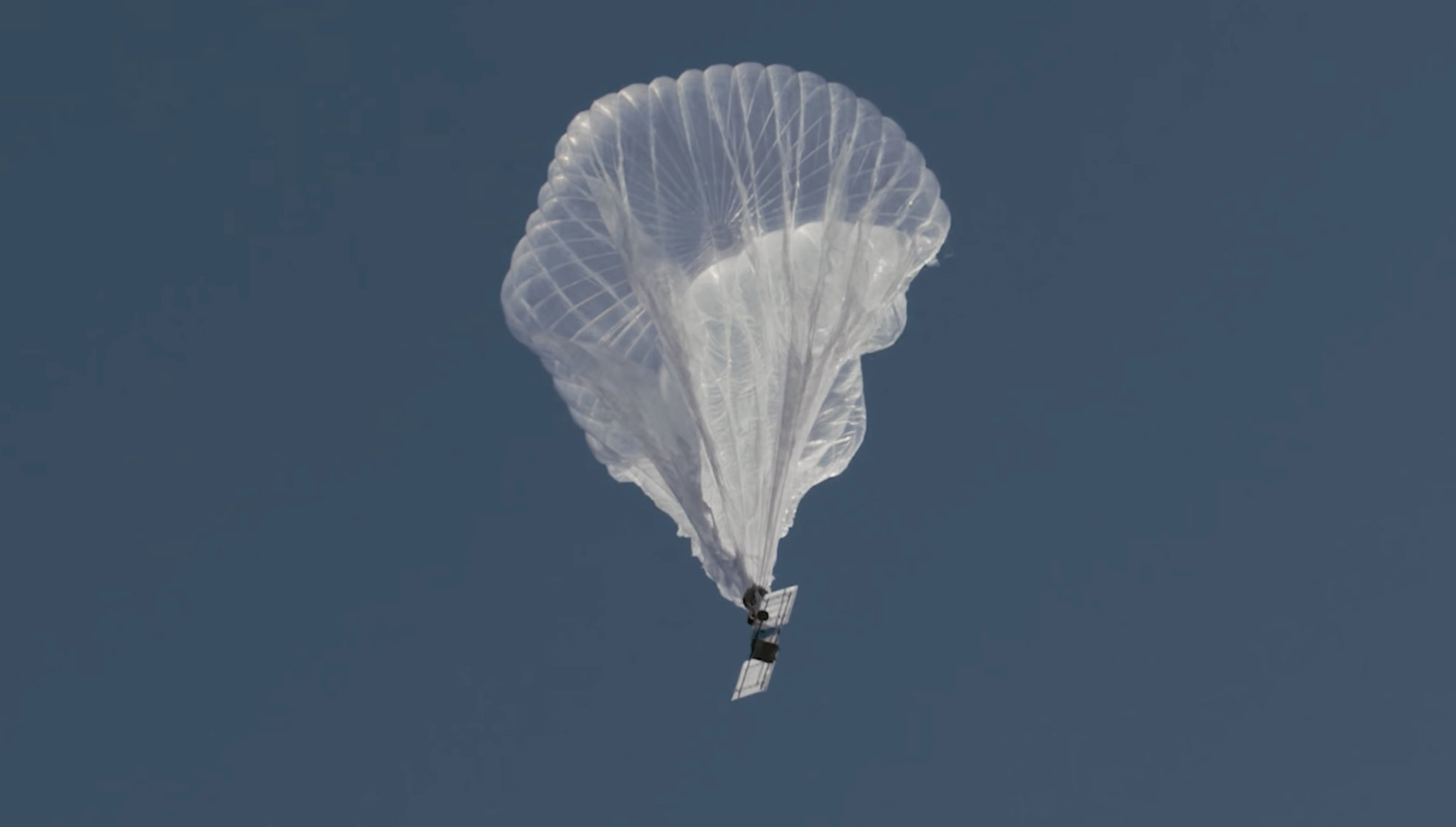 File photo of a partially inflated Raven Aerostar balloon just after launch. Still image from Aerostar video.
This article was first published at Fire Aviation.
The US Forest Service is partnering with NASA to evaluate the use of two high-altitude long endurance drones to improve wildland firefighters’ situational awareness.
1. A balloon
Last week a balloon laden with a sophisticated package of electronics hovered 60,000 feet over the Moose Fire in Idaho. Its mission was to assist firefighters in improving and maintaining situational awareness. Some of them may have seen the shiny object the size of a football stadium, even though it was more than 11 miles above the incident.
The company that built and operates the aircraft, Aerostar, calls it STRATO, or Strategic Radio and Tactical Overwatch, a technology that is in the research and development phase.
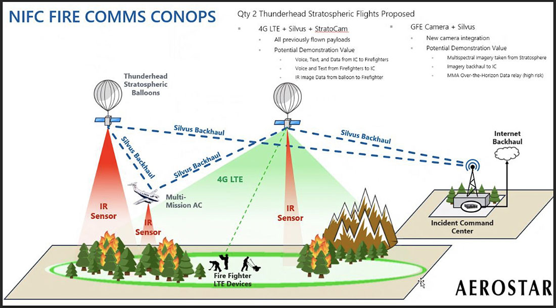 Illustration of how a Thunderhead Stratospheric balloon can assist wildland firefighters.
The STRATO is basically a giant mylar balloon with solar panels, batteries, radio equipment, cameras, and sensors. It has the capability to collect infrared and visual data, broadcast an LTE (cell phone) signal, has a high-band radio that can enable push to talk communications, and can operate a WiFi network. The huge helium balloon can hover over an incident in the stratosphere taking pictures, delivering data to incident managers, and providing communications options to the Incident Command Post and crews on the ground.
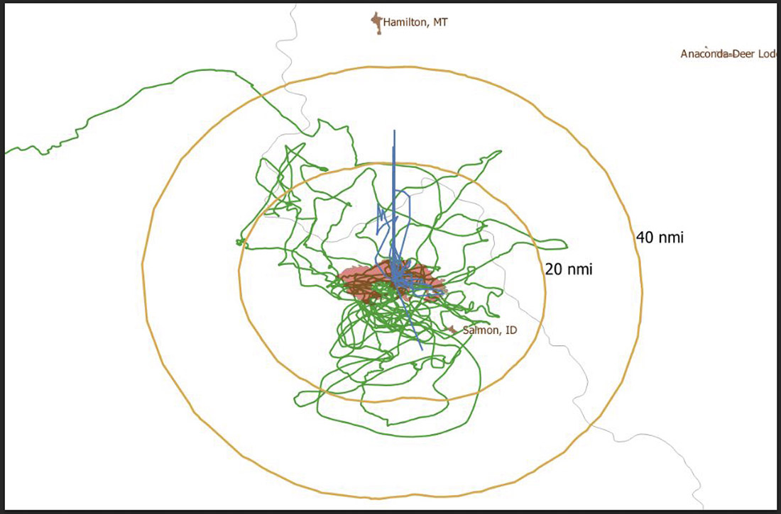 Flight path of an Aerostar Thunderhead Stratospheric balloon over the Moose Fire the week of August 7, 2022.
Last October Fire Aviation wrote about the system operated by Aerostar, a company based near Sioux Falls, South Dakota, which has been working with lighter than air technologies since 1956. We contacted the Communications Manager for the company, Lisa McElrath, who told us that in June, July, and August of 2021 they launched one of their Thunderhead Balloons from South Dakota and flew it west to monitor wildfires. While traveling more than 16,000 miles during its 70-day flight it engaged in station-seeking above four active fires for the company’s research and development. It collected visible and thermal imagery data for extended periods of time on the Robertson Draw Fire (Montana), the Dixie Fire (California), the Dixie-Jumbo Fire (Idaho), and the Dry Gulch/Lick Creek Fire (Washington).
In October we asked Ms. McElrath if Aerostar had been cooperating with the federal land management agencies in mapping fires. She said not yet, but that representatives from the National Interagency Fire Center had reached out to them and expressed interest in discussions after the fire season slowed down. But this year the US Forest Service is officially cooperating in the pilot project.
“We can provide real-time imagery from the balloon today in the visible and infrared,” Ms. McElrath said. “In the future, the goal would be to automate the detection and download of critical imagery, fire perimeters, likely fire-starts, and other key information via onboard processing so that more actionable information would be available. We see stratospheric balloon technology being the key to cost-effective, scalable wildfire surveillance that reduces time between new fire detection and response. Effectively, balloons can alert firefighters to a new fire while it is still small, before the fire grows into something newsworthy and very expensive.”
She said the balloons can also serve as radio repeaters for personnel on the ground and could collect information from tracking devices on firefighting resources which could then be displayed on a map.
More flights over fires are being planned, said Sean Triplett, Team Lead for Tools and Technology, U.S. Forest Service, Fire and Aviation Management. He said NASA is matching the funding the Forest Service is putting toward the flights this year.
2. Fixed wing aircraft
 Swift Engineering’s SULE HALE-UAS. Swift Engineering photo.
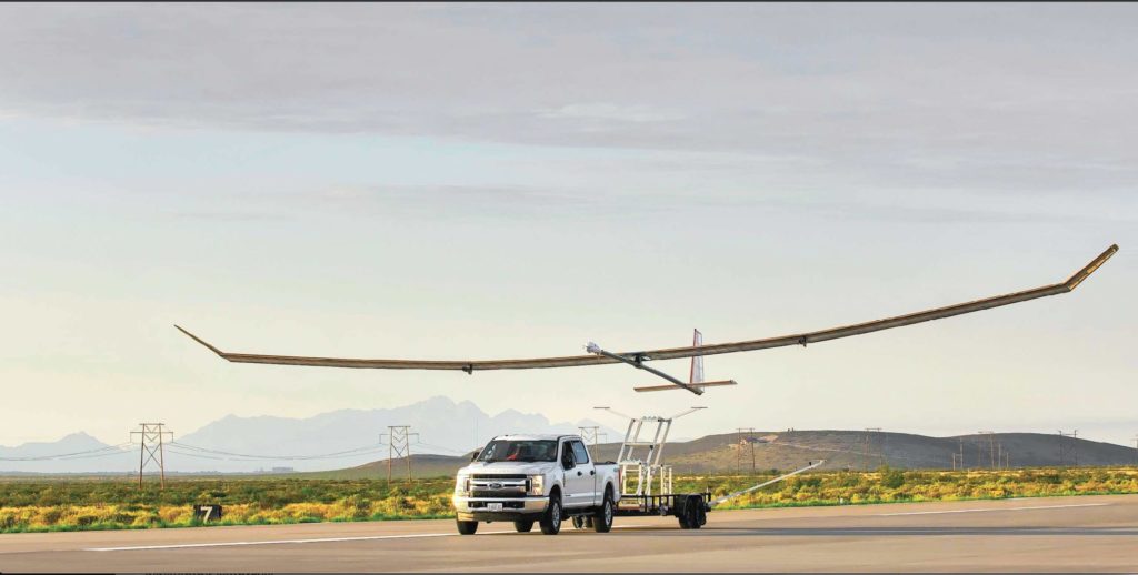
Another High Altitude Long Endurance (HALE) aircraft the Forest Service is looking at is Swift Engineering’s SULE HALE-UAS, capable of staying aloft for more than 30 days at a time. The Forest Service, again partnering with NASA, has issued a contract with the company and as of March 31, 2021 they had conducted more than 10 demonstrations of the solar powered fixed wing aircraft.
The key to long duration flight using solar power on an airplane is to have a top surface area large enough for the solar cells needed to power the electric motors day and night, using a battery for night operations. Large wings mean more solar cells, but also more wind resistance. So the answer, using today’s technology, is to fly very high at 60,000 to 70,000 feet where the air is thin, the sunlight on the solar panels is strong, and there is less wind resistance.
The SULE, which took its first flight in July of 2020 has a 72-foot wingspan, operates at 70,000 feet, and can carry a payload of 15 to 22 pounds.
“A series of mid-altitude and high-altitude flights is being undertaken, Mr. Triplett told Fire Aviation on Wednesday. “At this point, the platform is only providing remote sensing products. However, if successful, additional systems may be incorporated.” Those added systems could include a radio system to provide connectivity enabling the tracking of firefighting resources on the ground in addition to live imagery of the fire.
Mr. Triplett said one advantage of having NASA as part of the project is that they can handle the airworthiness of the aircraft and interactions with the FAA.
The Swift Engineering video below shows what may be the first flight of the SULE two years ago.
A step toward the Holy Grail of Wildland Firefighter Safety?
Our view is that providing to wildland fire supervisors the real time location of both the fire and firefighting resources is the Holy Grail of Wildland Firefighting Safety. Lacking this information has led to at least two dozen firefighter fatalities. These High Altitude Long Endurance aircraft 13 miles above the fire could be an important link to transmit live video of the fire to personnel and provide radio connectivity enabling the tracking of firefighting resources on the ground even when they are in steep rugged topography. Of course the resources would need to have the hardware necessary to transmit the coordinates of their locations.
The John D. Dingell, Jr. Conservation, Management, and Recreation Act which became law March 12, 2019 required that by March 12, 2021 the five federal land management agencies “…develop consistent protocols and plans for the use on wildland fires of unmanned aircraft system technologies, including for the development of real-time maps of the location of wildland fires.”
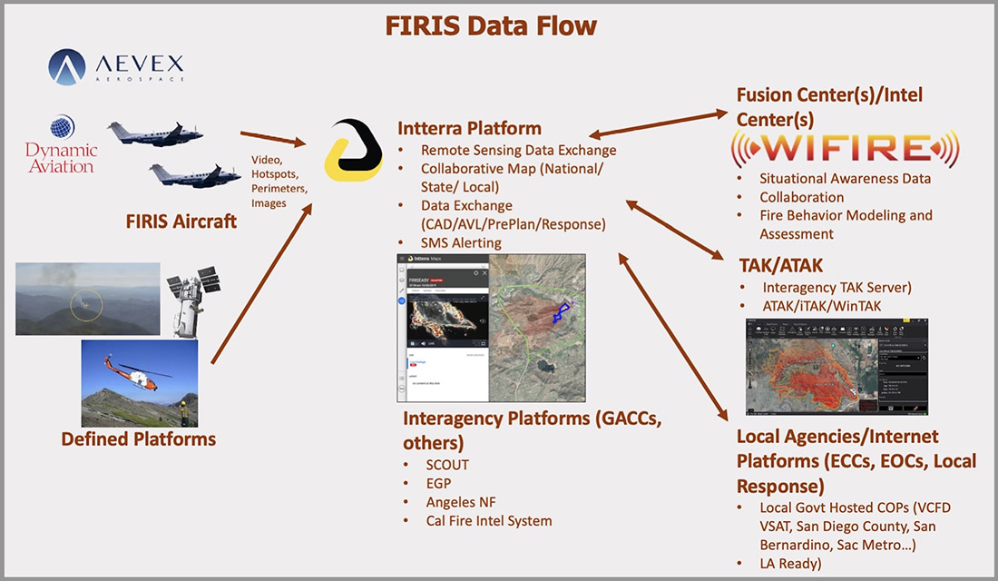
While this technology has been demonstrated, real time mapping appears to be far from being used routinely, at least within the Federal agencies. But at the state level, the Governor of California has requested $30 million in their next budget for 31 positions and funds for the state’s Office of Emergency Services to operate Real-Time Intelligence System (FIRIS) aircraft that have shown that they can provide real time fire mapping information. A pilot program for FIRIS first got off the ground September 1, 2019 thanks to funding secured in the 2019-2020 California state budget. This year two FIRIS ships have been assisting firefighters.
The Dingell Act also mandated that the five federal land management agencies “jointly develop and operate a tracking system to remotely locate the positions of fire resources for use by wildland firefighters, including, at a minimum, any fire resources assigned to Federal type 1 wildland fire incident management teams”, again, due by March 12, 2021.
Other solar powered high-altitude aircraft
An aircraft that the Forest Service is not involved with is the Zephyr, made by AIRBUS. It is an unmanned, solar-powered fixed wing aircraft designed to stay aloft at high altitude for months.
 AIRBUS Zephyr, stratospheric unmanned aerial vehicle. Airbus image.
In its latest test flight that began June 15, 2022 the Zephyr took off from the U.S. Army’s Yuma, Arizona Proving Ground and has been flying patterns over the Yuma Test Range and Kofa National Wildlife Refuge ever since. Now 63 days later the flight has smashed Zephyr’s previous record of 25 days that it set in August 2018. When we checked August 17 it was cruising at 40 knots ground speed 70,500 feet above the Earth.
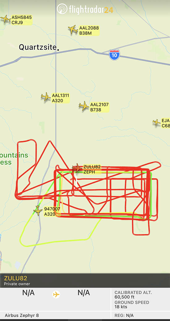 Flight path of ZULU82 Zephyr, a solar-powered unmanned aircraft on August 16, 2022, day 62 of a flight that began June 15, 2022.
UPDATE at 7:35 p.m. MDT August 21, 2022
The flight of the Zephyr has ended.
“Following 64 days of stratospheric flight and the completion of numerous mission objectives, Zephyr experienced circumstances that ended its current flight. No personal injury occurred,” AIRBUS said in a statement.
Simple Flying reported that a catastrophic loss of altitude occured on August 19 after flying for 64 days straight:
On its final day of operations, it was tracking around over the vast Arizona Desert, about halfway between Phoenix and Mexicali, Baja California. Flying slightly lower than was typical, at some 45,000 – 50,000 feet, it had completed an S-shape maneuver at around 50 – 60 knots when something went catastrophically wrong. ADSB data shows a vertical descent rate which rapidly increased, topping out at a speed of 4,544 feet per minute. Although unconfirmed by Airbus, it does seem that the Zephyr met a rather unglamorous end.
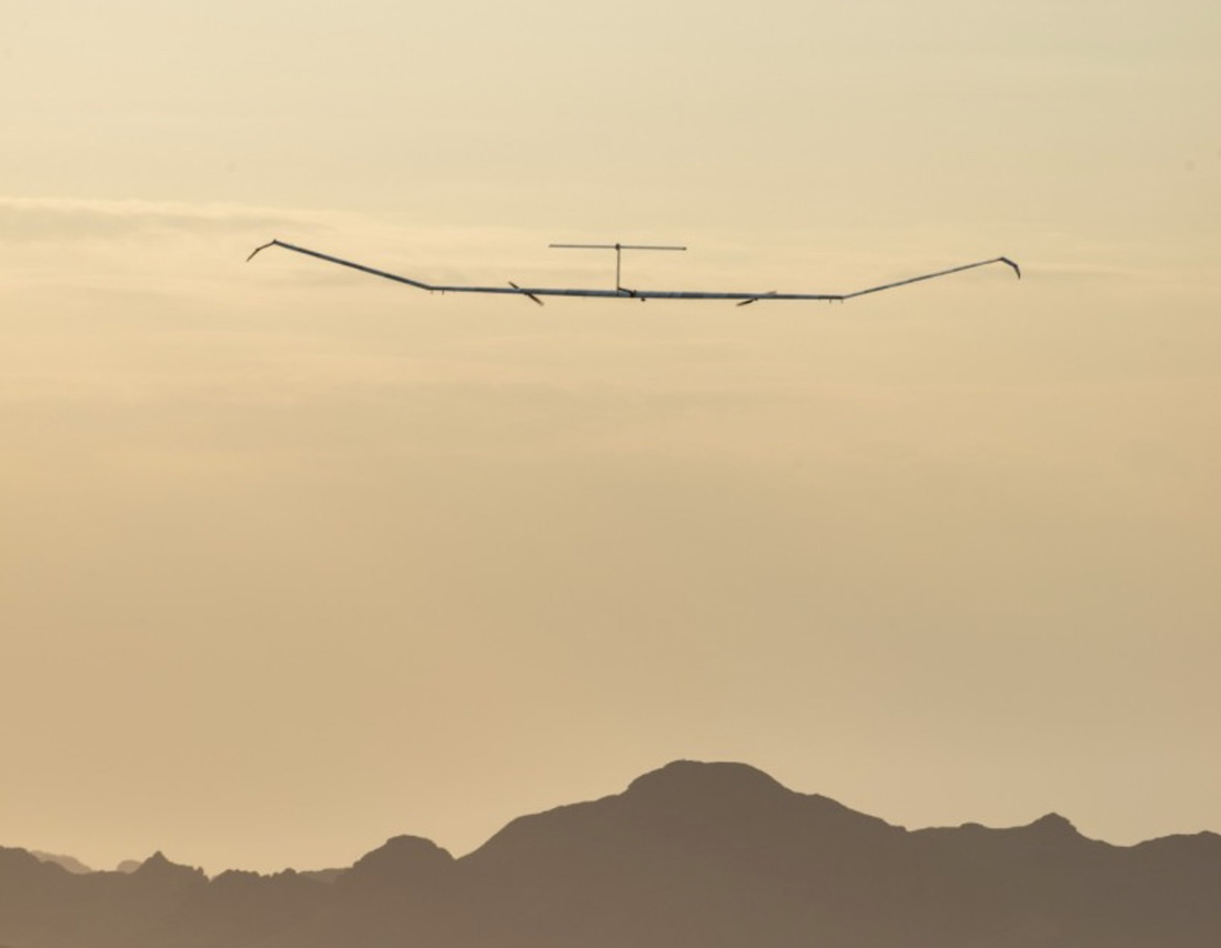 The Airbus Zephyr S during a 2021 test flight. US Army photo.
DHS tests next generation Wildland Urban Interface alerting technology
 Evacuation at the Fort McMurray Fire in Alberta, Canada May, 2016.
The Department of Homeland Security hosted a proof-of-concept demonstration of the Wildland Urban Interface (WUI) integration model Monday, August 15, in Fairfax, VA. The model integrates next generation technologies with the Federal Emergency Management Agency Integrated Public Alert Warning System (IPAWS), enabling alerting authorities to disseminate Wireless Emergency Alerts with new capabilities such as displaying hazard and evacuation alert information on the “infotainment” screens in vehicles.
The DHS is working with partners to develop a new method for putting life safety alerts, such as evacuation alerts, into navigation applications during emergencies. Doing so will not only provide alerts to an increasingly mobile public, but also help the public make informed navigation decisions in all-hazard situations.
“Effective communication of emergency fire information and evacuation routes to people in an endangered area is a necessity for first responders striving to manage emergency operations and guide safe public response actions,” said Norman Speicher, Department of Homeland Security Science and Technology Directorate program manager. “Connecting emergency management tools to situations in the WUI will help emergency management officials achieve better routes and procedures by utilizing cutting-edge technologies that help define, share, and manage the status, and communicate evacuation routes and safety zones in real-time.”
Forest Service evaluating two high altitude drones to assist wildland firefighters
Illustration of how a Thunderhead Stratospheric balloon can assist wildland firefighters.The US Forest Service is partnering with NASA to evaluate the use of two high-altitude long endurance drones to improve wildland firefighters’ situational awareness.
1. A balloon
Last week a balloon laden with a sophisticated package of electronics hovered 60,000 feet over the Moose Fire in Idaho. Its mission was to assist firefighters in improving and maintaining situational awareness. Some of them may have seen the shiny object the size of a football stadium, even though it was more than 11 miles above the incident.
The company that built and operates the aircraft, Aerostar, calls it STRATO, or Strategic Radio and Tactical Overwatch, a technology that is in the research and development phase.
File photo of a partially inflated Raven Aerostar balloon just after launch. Still image from Aerostar video.The STRATO is basically a giant mylar balloon with solar panels, batteries, radio equipment, cameras, and sensors. It has the capability to collect infrared and visual data, broadcast an LTE (cell phone) signal, has a high-band radio that can enable push to talk communications, and can operate a WiFi network. The huge helium balloon can hover over an incident in the stratosphere taking pictures, delivering data to incident managers, and providing communications options to the Incident Command Post and crews on the ground.
Flight path of an Aerostar Thunderhead Stratospheric balloon over the Moose Fire the week of August 7, 2022.Last October Fire Aviation wrote about the system operated by Aerostar, a company based near Sioux Falls, South Dakota, which has been working with lighter than air technologies since 1956. We contacted the Communications Manager for the company, Lisa McElrath, who told us that in June, July, and August of 2021 they launched one of their Thunderhead Balloons from South Dakota and flew it west to monitor wildfires. While traveling more than 16,000 miles during its 70-day flight it engaged in station-seeking above four active fires for the company’s research and development. It collected visible and thermal imagery data for extended periods of time on the Robertson Draw Fire (Montana), the Dixie Fire (California), the Dixie-Jumbo Fire (Idaho), and the Dry Gulch/Lick Creek Fire (Washington).
In October we asked Ms. McElrath if Aerostar had been cooperating with the federal land management agencies in mapping fires. She said not yet, but that representatives from the National Interagency Fire Center had reached out to them and expressed interest in discussions after the fire season slowed down. But this year the US Forest Service is officially cooperating in the pilot project.
“We can provide real-time imagery from the balloon today in the visible and infrared,” Ms. McElrath said. “In the future, the goal would be to automate the detection and download of critical imagery, fire perimeters, likely fire-starts, and other key information via onboard processing so that more actionable information would be available. We see stratospheric balloon technology being the key to cost-effective, scalable wildfire surveillance that reduces time between new fire detection and response. Effectively, balloons can alert firefighters to a new fire while it is still small, before the fire grows into something newsworthy and very expensive.”
She said the balloons can also serve as radio repeaters for personnel on the ground and could collect information from tracking devices on firefighting resources which could then be displayed on a map.
More flights over fires are being planned, said Sean Triplett, Team Lead for Tools and Technology, U.S. Forest Service, Fire and Aviation Management. He said NASA is matching the funding the Forest Service is putting toward the flights this year.
2. Fixed wing aircraft
Swift Engineering’s SULE HALE-UAS. Swift Engineering photo.Another High Altitude Long Endurance (HALE) aircraft the Forest Service is looking at is Swift Engineering’s SULE HALE-UAS, capable of staying aloft for more than 30 days at a time. The Forest Service, again partnering with NASA, has issued a contract with the company and as of March 31, 2021 they had conducted more than 10 demonstrations of the solar powered fixed wing aircraft.
The key to long duration flight using solar power on an airplane is to have a top surface area large enough for the solar cells needed to power the electric motors day and night, using a battery for night operations. Large wings mean more solar cells, but also more wind resistance. So the answer, using today’s technology, is to fly very high at 60,000 to 70,000 feet where the air is thin, the sunlight on the solar panels is strong, and there is less wind resistance.
The SULE, which took its first flight in July of 2020 has a 72-foot wingspan, operates at 70,000 feet, and can carry a payload of 15 to 22 pounds.
“A series of mid-altitude and high-altitude flights is being undertaken, Mr. Triplett told Fire Aviation on Wednesday. “At this point, the platform is only providing remote sensing products. However, if successful, additional systems may be incorporated.” Those added systems could include a radio system to provide connectivity enabling the tracking of firefighting resources on the ground in addition to live imagery of the fire.
Mr. Triplett said one advantage of having NASA as part of the project is that they can handle the airworthiness of the aircraft and interactions with the FAA.
The Swift Engineering video below shows what may be the first flight of the SULE two years ago.
A step toward the Holy Grail of Wildland Firefighter Safety?
Our view is that providing to wildland fire supervisors the real time location of both the fire and firefighting resources is the Holy Grail of Wildland Firefighting Safety. Lacking this information has led to at least two dozen firefighter fatalities. These High Altitude Long Endurance aircraft 13 miles above the fire could be an important link to transmit live video of the fire to personnel and provide radio connectivity enabling the tracking of firefighting resources on the ground even when they are in steep rugged topography. Of course the resources would need to have the hardware necessary to transmit the coordinates of their locations.
The John D. Dingell, Jr. Conservation, Management, and Recreation Act which became law March 12, 2019 required that by March 12, 2021 the five federal land management agencies “…develop consistent protocols and plans for the use on wildland fires of unmanned aircraft system technologies, including for the development of real-time maps of the location of wildland fires.”
While this technology has been demonstrated, real time mapping appears to be far from being used routinely, at least within the Federal agencies. But at the state level, the Governor of California has requested $30 million in their next budget for 31 positions and funds for the state’s Office of Emergency Services to operate Real-Time Intelligence System (FIRIS) aircraft that have shown that they can provide real time fire mapping information. A pilot program for FIRIS first got off the ground September 1, 2019 thanks to funding secured in the 2019-2020 California state budget. This year two FIRIS ships have been assisting firefighters.
The Dingell Act also mandated that the five federal land management agencies “jointly develop and operate a tracking system to remotely locate the positions of fire resources for use by wildland firefighters, including, at a minimum, any fire resources assigned to Federal type 1 wildland fire incident management teams”, again, due by March 12, 2021.
Other solar powered high-altitude aircraft
An aircraft that the Forest Service is not involved with is the Zephyr, made by AIRBUS. It is an unmanned, solar-powered fixed wing aircraft designed to stay aloft at high altitude for months.
AIRBUS Zephyr, stratospheric unmanned aerial vehicle. Airbus image.In its latest test flight that began June 15, 2022 the Zephyr took off from the U.S. Army’s Yuma, Arizona Proving Ground and has been flying patterns over the Yuma Test Range and Kofa National Wildlife Refuge ever since. Now 63 days later the flight has smashed Zephyr’s previous record of 25 days that it set in August 2018. When we checked August 17 it was cruising at 40 knots ground speed 70,500 feet above the Earth.
Flight path of ZULU82 Zephyr, a solar-powered unmanned aircraft on August 16, 2022, day 62 of a flight that began June 15, 2022.UPDATE at 7:32 p.m. MDT August 21, 2022
The flight of the Zephyr has ended.
“Following 64 days of stratospheric flight and the completion of numerous mission objectives, Zephyr experienced circumstances that ended its current flight. No personal injury occurred,” AIRBUS said in a statement.
Simple Flying reported that a catastrophic loss of altitude occured on August 19 after flying for 64 days straight:
On its final day of operations, it was tracking around over the vast Arizona Desert, about halfway between Phoenix and Mexicali, Baja California. Flying slightly lower than was typical, at some 45,000 – 50,000 feet, it had completed an S-shape maneuver at around 50 – 60 knots when something went catastrophically wrong. ADSB data shows a vertical descent rate which rapidly increased, topping out at a speed of 4,544 feet per minute. Although unconfirmed by Airbus, it does seem that the Zephyr met a rather unglamorous end.
 The Airbus Zephyr S during a 2021 test flight. US Army photo.
Video of aircraft working the Ross Fire in Idaho
 Two Single Engine Air Tankers at the Ross Fire in Idaho, August, 2022. Still image from Airailimages video.
Fred Johnsen of Airailimages sent us information about a video he shot in Idaho at the Pocatello Airport and at the nearby Ross Fire. The video is below, just after Fred’s description.
“A wildfire burned over 6,300 acres on the Shoshone-Bannock Fort Hall Indian Reservation northeast of Pocatello, Idaho. Visible in the night sky on August 9, 2022, the Ross Fork fire was still active the following day as the Fort Hall Fire Department battled the flames on the ground, assisted by aerial firefighting assets staging out of the Pocatello airport. A number of Fort Hall reservation residents were evacuated to the Shoshone-Bannock hotel while the fire was brought under control. Aircraft fighting the Ross Fork fire included an Erickson MD-87 jet airliner tanker, an RJ85 jet tanker, several turboprop Single Engine Air Tankers (SEATs) and bucket-wielding helicopters. A turbo Commander served as an air attack coordination aircraft over the fire scene.”
Thank you, Fred!