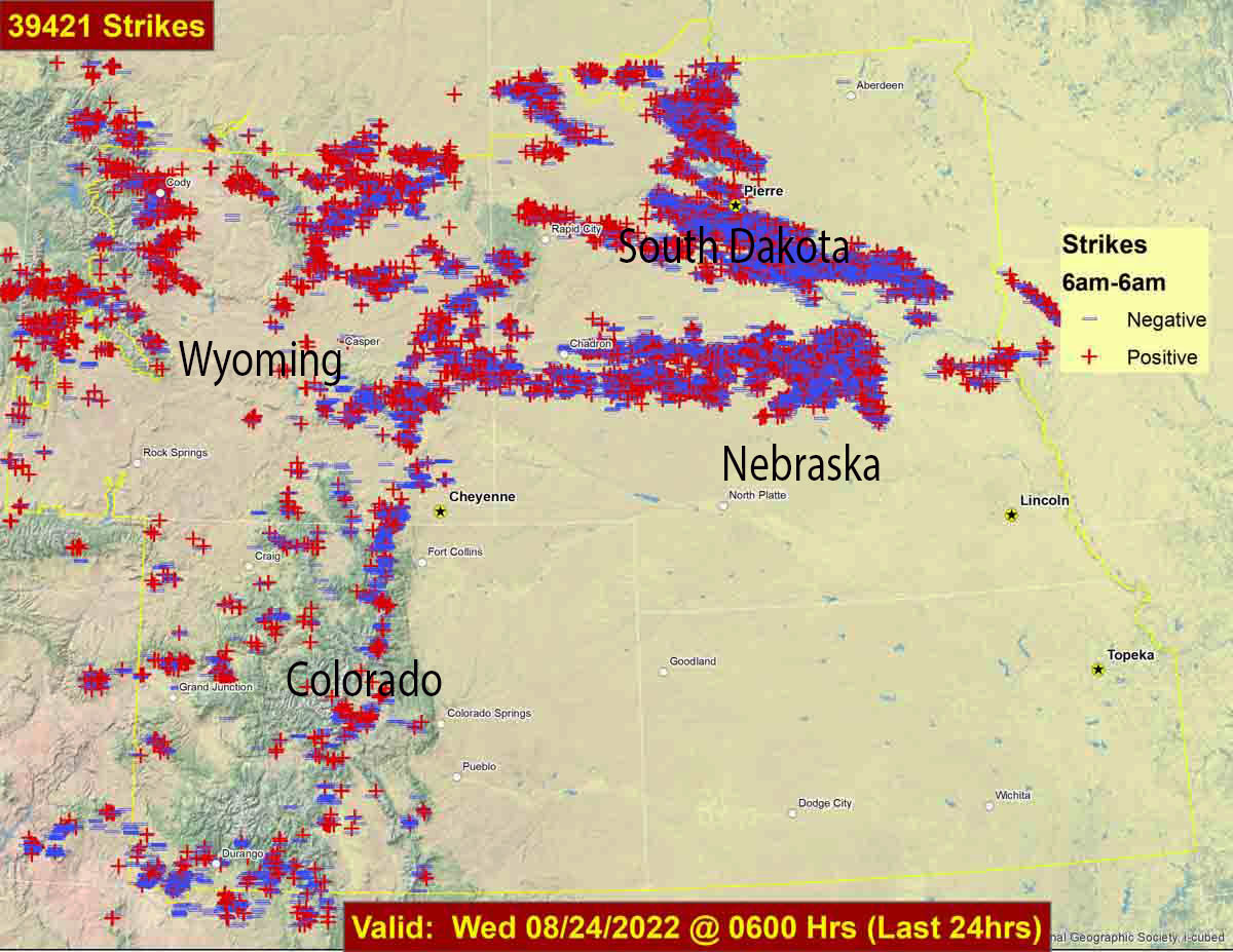
Lightning strikes during 24-hour period ending at 6 a.m. Aug. 24, 2022. Lightning strike data from Rocky Mountain Area Coordination Center.
During the 24-hour period ending at 6 a.m. Wednesday 39,421 lightning strikes were detected in parts of Wyoming, Colorado, South Dakota, and Nebraska. In many areas there was not a great deal of rain accompanying the lightning.
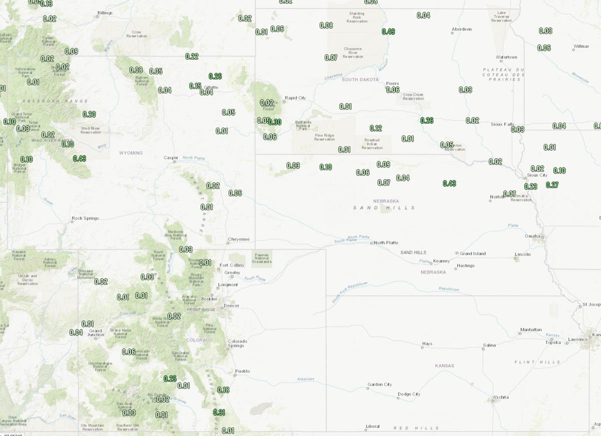
Precipitation during 24-hour period ending at noon Aug. 24, 2022.
The weather forecast for Cheyenne, Wyoming on Wednesday is for 84 degrees, 12 mph winds out of the southeast, 30 percent cloud cover, and 22 percent relative humidity.
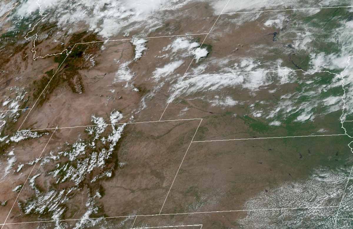
The satellite photo taken at 11:56 a.m. MDT on Wednesday shows partly cloudy skies over the general region.
Anheuser-Busch has come up with a unique way to promote one of their brands while also, perhaps, reducing the chances of an illegal campfire starting what could become a devastating wildfire.
The company is giving away in certain areas of Colorado solar powered flameless cookers which supposedly can be used by campers to prepare a warm meal in a remote area.
“On average, 85% of forest fires are caused by humans and many of those man-made disasters are attributed to poorly attended campfires,” they wrote on their website. “That’s why Busch Light is distributing Busch Light Solar Cookers at the peak of Colorado camping season, offering a flame-free way to enjoy a warm meal and ice-cold beers with fire safety in mind.”
Website visitors can sign upfor a chance to get a free cooker at local Colorado fire departments in Red Feather Lakes (August 19th), Nederland (August 26th), or Estes Park (September 2nd) through Labor Day weekend.
The cooker appears to be very similar to an item sold on Amazon for $41.
Person suspected of stealing solar panel and battery from Oregon DOF fire camera system August 14, 2022. Image from surveillance footage.
An anonymous tip led to the arrest of a thief who broke into an Oregon Department of Forestry (ODF) lookout tower in the Prospect area last week [and stole batteries and solar panels used to power the lookout tower’s fire detection camera]. The suspect, Chad Allen McPherson, 30, of Prospect, was indicted today, August 23, by a Grand Jury and charged with second-degree burglary, first-degree theft, first-degree criminal mischief, possession of burglary tools, and felon in possession of a restricted weapon. McPherson is lodged in the Jackson County Jail and due to a parole violation for felon in possession of a firearm is not eligible for pre-trial release.
McPherson and another suspect were captured on surveillance footage breaking into the tower around 12:45 on Sunday, August 14. The additional suspect shown in the surveillance footage has not been identified. Jackson County Sheriff’s Office (JCSO) detectives have identified a person of interest and are actively working to identify the additional suspect by analyzing latent prints and submitting DNA.
JCSO detectives arrested McPherson during a traffic stop Friday after receiving the tip and matching his photos to the surveillance footage. After searching his vehicle, detectives discovered burglary tools. During a search warrant of his property on the 2000 block of Shelly Lane in Prospect, detectives found a restricted weapon he was prohibited from possessing as a convicted felon. Investigators also discovered a black-market marijuana grow on the property. Illegal Marijuana Enforcement Team (IMET) detectives served a search warrant and destroyed 256 cannabis plants and 300 lbs. of processed black-market marijuana on the property. There was no licensing for any type of cannabis growing, handling, or processing at this location.
Later Friday, Dispatch received a call about a duffel bag at the intersection of 1st Street and Highway 62 with a note which read “call the cops.” JCSO deputies retrieved the bag and it contained items matching that of the stolen ODF equipment. The solar panels and batteries are still missing. The theft disabled ODF’s early fire detection capability for the northeastern portion of Jackson County near Prospect. ODF is currently working to get the camera system back up and running.
This case is ongoing with detectives working additional leads. If you have any information on the additional suspect or the whereabouts of the missing equipment, call the JCSO Tip Line at (541) 774-8333 and reference case 22-4725.
From the Jackson County Sheriff’s Office in Oregon.
After the arrest the Oregon Department of Forestry said, “Some of the equipment has been retrieved, however we’re still moving forward in ordering the parts and pieces we need to get our camera back up and running; early fire detection is one of our top priorities.”
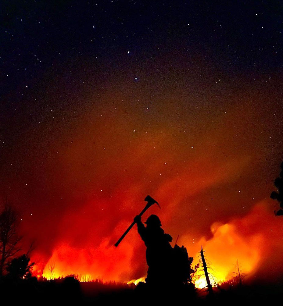
Firefighter on the Cerro Paledo Fire in New Mexico, May, 2022 by Blake McHugh.
Last week President Biden signed H.R. 6943, the Public Safety Officer Support Act, into law. The legislation expands death and disability benefits under the Public Safety Officers’ Benefits (PSOB) program to include first responders who die by suicide or are disabled by traumatic experiences.
The new law will:
Allow public safety officers to seek disability benefits for PTSD linked to severe trauma by directing the PSOB to designate work-related PTSD and acute stress disorders as a line of duty injury for eligible officers as well as those who are permanently disabled as a result of attempted suicide; and
Allow families of public safety officers who die by trauma-linked suicide to apply for death benefits by directing the PSOB to presume that suicides are a result of job duties in certain traumatic circumstances where there is evidence that PTSD or acute stress disorder would be the cause of the injury.
The bill states that first responders or their survivors may qualify for benefits if their suicide or post-traumatic stress disorder was related to being exposed to “a harrowing circumstance posing an extraordinary and significant danger or threat to the life of or of serious bodily harm to any individual.” There are other requirements and details which are in the copy of the five-page bill below:
The US Forest Service is partnering with NASA to evaluate the use of two high-altitude long endurance drones to improve wildland firefighters’ situational awareness.
1. A balloon
Last week a balloon laden with a sophisticated package of electronics hovered 60,000 feet over the Moose Fire in Idaho. Its mission was to assist firefighters in improving and maintaining situational awareness. Some of them may have seen the shiny object the size of a football stadium, even though it was more than 11 miles above the incident.
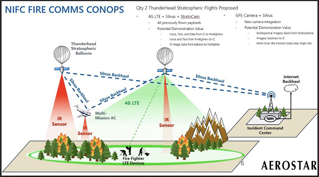
The company that built and operates the aircraft, Aerostar, calls it STRATO, or Strategic Radio and Tactical Overwatch, a technology that is in the research and development phase.
Illustration of how a Thunderhead Stratospheric balloon can assist wildland firefighters.
The STRATO is basically a giant mylar balloon with solar panels, batteries, radio equipment, cameras, and sensors. It has the capability to collect infrared and visual data, broadcast an LTE (cell phone) signal, has a high-band radio that can enable push to talk communications, and can operate a WiFi network. The huge helium balloon can hover over an incident in the stratosphere taking pictures, delivering data to incident managers, and providing communications options to the Incident Command Post and crews on the ground.
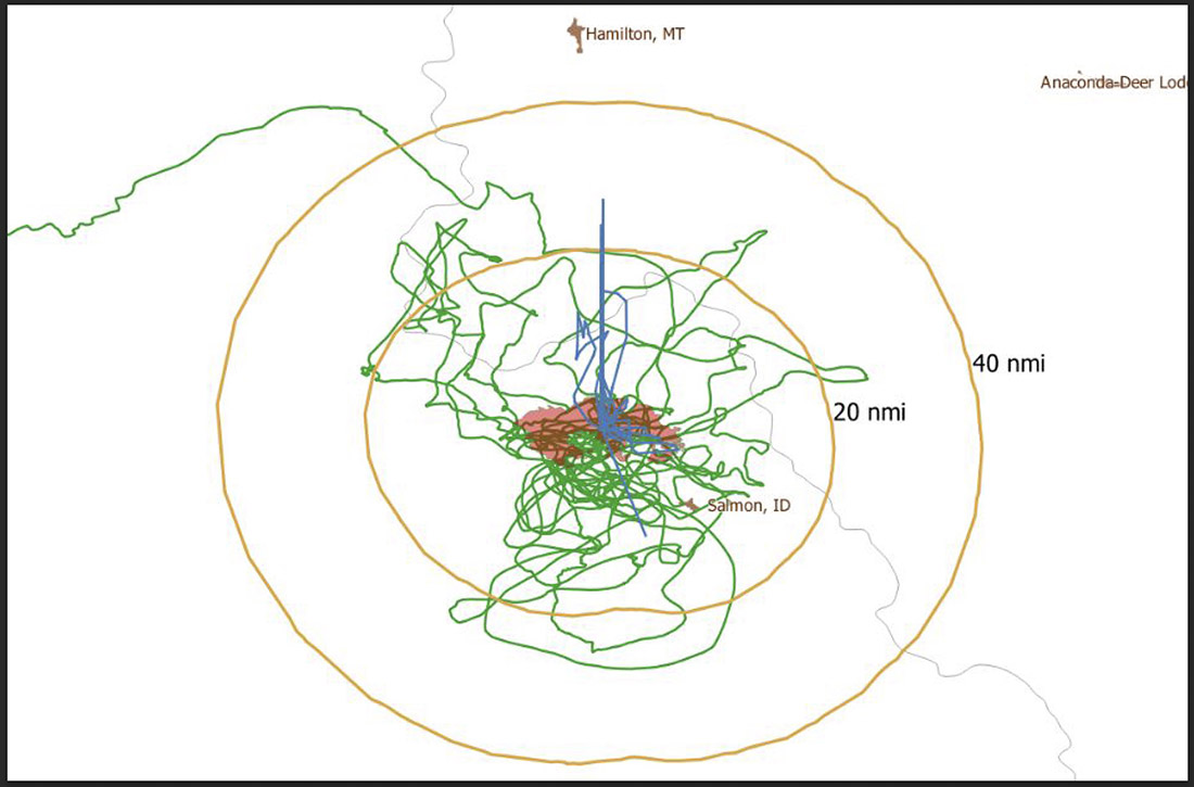
Flight path of an Aerostar Thunderhead Stratospheric balloon over the Moose Fire the week of August 7, 2022.
Last October Fire Aviation wrote about the system operated by Aerostar, a company based near Sioux Falls, South Dakota, which has been working with lighter than air technologies since 1956. We contacted the Communications Manager for the company, Lisa McElrath, who told us that in June, July, and August of 2021 they launched one of their Thunderhead Balloons from South Dakota and flew it west to monitor wildfires. While traveling more than 16,000 miles during its 70-day flight it engaged in station-seeking above four active fires for the company’s research and development. It collected visible and thermal imagery data for extended periods of time on the Robertson Draw Fire (Montana), the Dixie Fire (California), the Dixie-Jumbo Fire (Idaho), and the Dry Gulch/Lick Creek Fire (Washington).
In October we asked Ms. McElrath if Aerostar had been cooperating with the federal land management agencies in mapping fires. She said not yet, but that representatives from the National Interagency Fire Center had reached out to them and expressed interest in discussions after the fire season slowed down. But this year the US Forest Service is officially cooperating in the pilot project.
“We can provide real-time imagery from the balloon today in the visible and infrared,” Ms. McElrath said. “In the future, the goal would be to automate the detection and download of critical imagery, fire perimeters, likely fire-starts, and other key information via onboard processing so that more actionable information would be available. We see stratospheric balloon technology being the key to cost-effective, scalable wildfire surveillance that reduces time between new fire detection and response. Effectively, balloons can alert firefighters to a new fire while it is still small, before the fire grows into something newsworthy and very expensive.”
She said the balloons can also serve as radio repeaters for personnel on the ground and could collect information from tracking devices on firefighting resources which could then be displayed on a map.
More flights over fires are being planned, said Sean Triplett, Team Lead for Tools and Technology, U.S. Forest Service, Fire and Aviation Management. He said NASA is matching the funding the Forest Service is putting toward the flights this year.
2. Fixed wing aircraft
Swift Engineering’s SULE HALE-UAS. Swift Engineering photo.
Another High Altitude Long Endurance (HALE) aircraft the Forest Service is looking at is Swift Engineering’s SULE HALE-UAS, capable of staying aloft for more than 30 days at a time. The Forest Service, again partnering with NASA, has issued a contract with the company and as of March 31, 2021 they had conducted more than 10 demonstrations of the solar powered fixed wing aircraft.
The key to long duration flight using solar power on an airplane is to have a top surface area large enough for the solar cells needed to power the electric motors day and night, using a battery for night operations. Large wings mean more solar cells, but also more wind resistance. So the answer, using today’s technology, is to fly very high at 60,000 to 70,000 feet where the air is thin, the sunlight on the solar panels is strong, and there is less wind resistance.
The SULE, which took its first flight in July of 2020 has a 72-foot wingspan, operates at 70,000 feet, and can carry a payload of 15 to 22 pounds.
“A series of mid-altitude and high-altitude flights is being undertaken, Mr. Triplett told Fire Aviation on Wednesday. “At this point, the platform is only providing remote sensing products. However, if successful, additional systems may be incorporated.” Those added systems could include a radio system to provide connectivity enabling the tracking of firefighting resources on the ground in addition to live imagery of the fire.
Mr. Triplett said one advantage of having NASA as part of the project is that they can handle the airworthiness of the aircraft and interactions with the FAA.
The Swift Engineering video below shows what may be the first flight of the SULE two years ago.
A step toward the Holy Grail of Wildland Firefighter Safety?
Our view is that providing to wildland fire supervisors the real time location of both the fire and firefighting resources is the Holy Grail of Wildland Firefighting Safety. Lacking this information has led to at least two dozen firefighter fatalities. These High Altitude Long Endurance aircraft 13 miles above the fire could be an important link to transmit live video of the fire to personnel and provide radio connectivity enabling the tracking of firefighting resources on the ground even when they are in steep rugged topography. Of course the resources would need to have the hardware necessary to transmit the coordinates of their locations.
The John D. Dingell, Jr. Conservation, Management, and Recreation Act which became law March 12, 2019 required that by March 12, 2021 the five federal land management agencies “…develop consistent protocols and plans for the use on wildland fires of unmanned aircraft system technologies, including for the development of real-time maps of the location of wildland fires.”
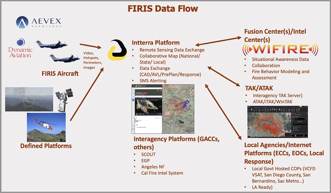
While this technology has been demonstrated, real time mapping appears to be far from being used routinely, at least within the Federal agencies. But at the state level, the Governor of California has requested $30 million in their next budget for 31 positions and funds for the state’s Office of Emergency Services to operate Real-Time Intelligence System (FIRIS) aircraft that have shown that they can provide real time fire mapping information. A pilot program for FIRIS first got off the ground September 1, 2019 thanks to funding secured in the 2019-2020 California state budget. This year two FIRIS ships have been assisting firefighters.
The Dingell Act also mandated that the five federal land management agencies “jointly develop and operate a tracking system to remotely locate the positions of fire resources for use by wildland firefighters, including, at a minimum, any fire resources assigned to Federal type 1 wildland fire incident management teams”, again, due by March 12, 2021.
Other solar powered high-altitude aircraft
An aircraft that the Forest Service is not involved with is the Zephyr, made by AIRBUS. It is an unmanned, solar-powered fixed wing aircraft designed to stay aloft at high altitude for months.
AIRBUS Zephyr, stratospheric unmanned aerial vehicle. Airbus image.
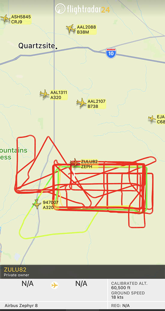
In its latest test flight that began June 15, 2022 the Zephyr took off from the U.S. Army’s Yuma, Arizona Proving Ground and has been flying patterns over the Yuma Test Range and Kofa National Wildlife Refuge ever since. Now 63 days later the flight has smashed Zephyr’s previous record of 25 days that it set in August 2018. When we checked August 17 it was cruising at 40 knots ground speed 70,500 feet above the Earth.
Flight path of ZULU82 Zephyr, a solar-powered unmanned aircraft on August 16, 2022, day 62 of a flight that began June 15, 2022.
UPDATE at 7:35 p.m. MDT August 21, 2022
The flight of the Zephyr has ended.
“Following 64 days of stratospheric flight and the completion of numerous mission objectives, Zephyr experienced circumstances that ended its current flight. No personal injury occurred,” AIRBUS said in a statement.
Simple Flying reported that a catastrophic loss of altitude occured on August 19 after flying for 64 days straight:
On its final day of operations, it was tracking around over the vast Arizona Desert, about halfway between Phoenix and Mexicali, Baja California. Flying slightly lower than was typical, at some 45,000 – 50,000 feet, it had completed an S-shape maneuver at around 50 – 60 knots when something went catastrophically wrong. ADSB data shows a vertical descent rate which rapidly increased, topping out at a speed of 4,544 feet per minute. Although unconfirmed by Airbus, it does seem that the Zephyr met a rather unglamorous end.
The Airbus Zephyr S during a 2021 test flight. US Army photo.
Evacuation at the Fort McMurray Fire in Alberta, Canada May, 2016.
The Department of Homeland Security hosted a proof-of-concept demonstration of the Wildland Urban Interface (WUI) integration model Monday, August 15, in Fairfax, VA. The model integrates next generation technologies with the Federal Emergency Management Agency Integrated Public Alert Warning System (IPAWS), enabling alerting authorities to disseminate Wireless Emergency Alerts with new capabilities such as displaying hazard and evacuation alert information on the “infotainment” screens in vehicles.
The DHS is working with partners to develop a new method for putting life safety alerts, such as evacuation alerts, into navigation applications during emergencies. Doing so will not only provide alerts to an increasingly mobile public, but also help the public make informed navigation decisions in all-hazard situations.
“Effective communication of emergency fire information and evacuation routes to people in an endangered area is a necessity for first responders striving to manage emergency operations and guide safe public response actions,” said Norman Speicher, Department of Homeland Security Science and Technology Directorate program manager. “Connecting emergency management tools to situations in the WUI will help emergency management officials achieve better routes and procedures by utilizing cutting-edge technologies that help define, share, and manage the status, and communicate evacuation routes and safety zones in real-time.”