Firefighters use innovative tactic to suppress Martin Fire

The fire has burned approximately 425,000 acres in Northern Nevada

(Originally published at 9:07 a.m. MDT July 10, 2018)

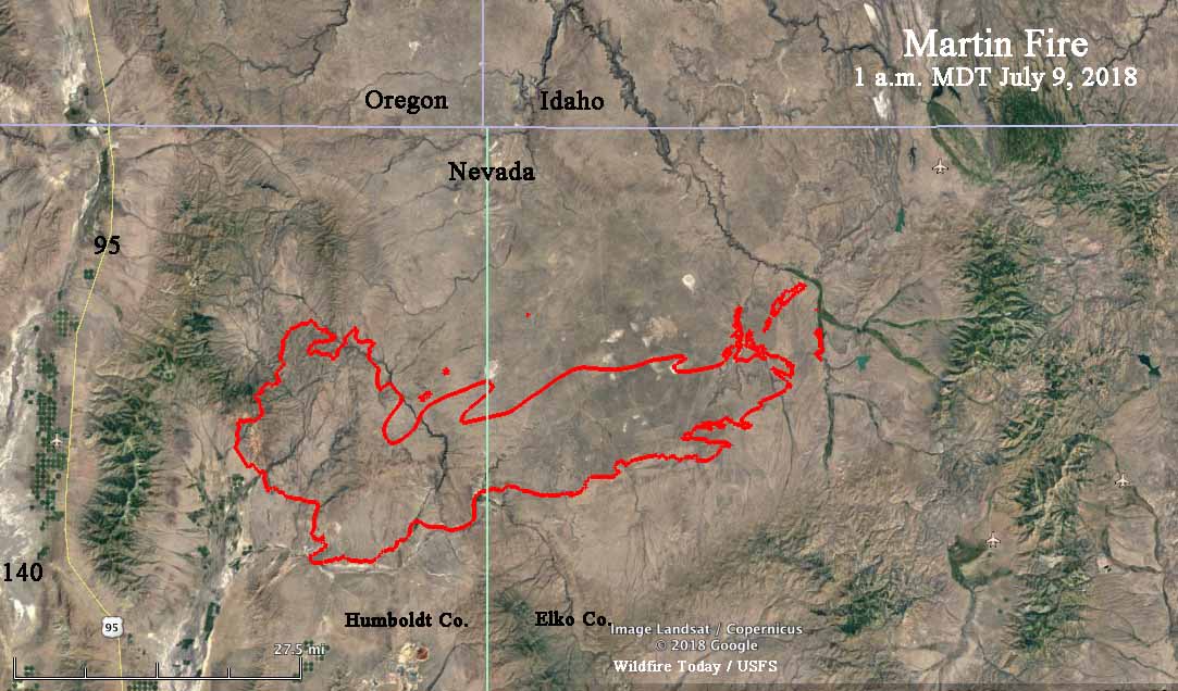
When a wildfire reaches 100,000 acres we often refer to it as a “megafire”. But what name do we put on a fire when it is four times the megafire threshold? The incident management team on the Martin Fire in Northern Nevada estimates their fire has burned approximately 425,000 acres. (I think we should reserve “gigafire” for a 1 million-acre fire.)

According to the National Situation Report there are only 634 personnel assigned. That is extremely low density of firefighters for such a huge fire — it stretches for 56 miles, west to east. Let’s assume for a moment that the perimeter is 150 miles (it is probably more). If so, that is about three people per mile of fireline, not including support personnel. However with mostly light fuels, there is less mop up after the spread is stopped, requiring fewer personnel.

map martin fire
The perimeter of the Martin Fire at 8:49 p.m. MDT July 10, 2018. The yellow line was from the previous day.

With the long distances, limited numbers of firefighters, and what may be difficult access, firefighters on the Martin Fire say they have developed an innovative approach to containing the blaze.

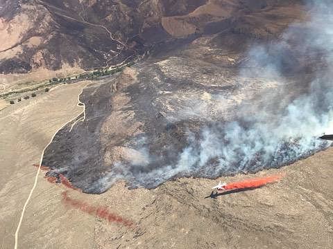
Firefighters know that air tankers and helicopters dropping water or retardant do not put out fires. Under ideal conditions they can slow them down enough to allow ground-based firefighters the opportunity to move in and actually put out the fire in that area. If there is no ground support working with the aircraft, the chances of success are very low. Reading between the lines of an update about the fire (embedded farther down) it appears that firefighters realized that in some instances the fire was spreading beyond retardant drops. It is not clear if the fire burned through the retardant, spotted over, or burned around the retardant.

martin fire retardant lines
Photo uploaded to InciWeb July 8, titled: “Martin Fire Crossing Retardant Lines”.

The tactic they decided to deploy involved using a combination of water-scooping air tankers, retardant-dropping air tankers, and firefighters building line on the ground. Aircraft that drop water, helicopters or fixed wing, apply it directly to the flaming front, since dropping it out ahead of the fire is often not effective since it does not adhere to the vegetation or have a long-term effect like retardant.

Here is how they described what they did:

Crews and equipment are making excellent progress building containment lines along the southeast flank of the fire. Due to the heavy, fine fuel loads, high winds and extremely fast fire rates of spread, an innovative tactic has been developed to combat these conditions using a three-prong attack. First, a long line of water is laid down by super scoopers, immediately followed by a retardant drop from air tankers. The approaching fire is thus cooled sufficiently that dozers and crews can safely and immediately dig a containment line right up against the side of the retardant line facing away from the flame front. Very close timing and coordination of air drops of water and retardant with ground forces has been proven to be the most effective tactic in these volatile burning conditions.

The part that may be innovative is slowing the flaming front with scooping air tankers AND then putting retardant just outside the edge of the fire. And as usual, quick followup by ground forces is essential.

Here are links to videos shot on the Martin Fire of drops by a DC-10 and two water scoopers.

Is it interesting that these firefighters, like many others in Canada and Europe, know that water-scooping air tankers are a very important tool in the toolbox. However, this year the U.S. Forest Service decided not to have any of them on exclusive use contract. The ones being used thankfully were available on a Call When Needed contract. And the number of retardant-dropping large air tankers on EU contracts were cut by one-third over last year.

They are also having success on the Martin Fire using a local task force:

Yesterday, fire spread slowed significantly due to the hard work of the local Elko Task Force that hit the head of the fire early Sunday morning and throughout the day. The task force took advantage of the fire naturally slowing as it entered flatter terrain with lesser fuel loads. Operations personnel report that the fire is moving into patches of greener vegetation such as Siberian wheat grass, which was planted as part of the BLM’s rehabilitation and fuel treatment efforts on previous fires. Green fuels slow the fire’s advance, making it easier for bulldozers and engines, with the aggressive assistance of super scooper air tankers and heavy and light helicopters, to catch up and get containment lines in place.

The head of the fire on the east side has approached and so far has not crossed the major drainage in the 3-D map below, thanks, no doubt, to the points brought out in the preceding quote.

map martin fire
A 3-D map showing the perimeter on the east side of the Martin Fire at 8:49 p.m. MDT July 10, 2018. The yellow line was from the previous day.

The Martin Fire is bringing in Beth Lund’s Type 1 Great Basin Management Team to handle the east side, while Taiga Rohrer’s Type 2 Great Basin Incident Management Team will continue to take care of the west side.

Two fires in Southern California you didn’t hear about

Long time fire photographer Jeff Zimmerman sent us these photos he shot at two recent Southern California fires that you did not hear about. Like many, many others, they were successfully attacked by firefighters and contained before growing into major conflagrations.

The photo above as well as the next three, were from the July 6 Hunter Fire off Sylvan road near Lake Hughes. Jeff got some quick shots with a camera phone of U.S. Forest Service and Los Angeles County personnel working at a vehicle fire that got into the brush at 5:20 a.m. during Red Flag Warning conditions. It burned one acre in addition to the vehicle.

Hunter Fire California Lake Hughes
Hunter Fire at Lake Hughes. Photo by Jeff Zimmerman.
Hunter Fire California Lake Hughes
Hunter Fire at Lake Hughes. Photo by Jeff Zimmerman.
Hunter Fire California Lake Hughes
Hunter Fire at Lake Hughes. Photo by Jeff Zimmerman.

On July 8 Jeff was at a fire in Lebec, California as firefighters from Kern County, BLM, USFS and LA County battled a stubborn vegetation fire. It was reported at 1:35 p.m. along Lebec and Lebec Oaks Road which brought a large response including fixed wing aircraft. No structures were damaged but several rural homes had to have structure protection put in place and large animals were evacuated. Firefighters stopped it at 62 acres. Jeff said extremely high temperatures and very low relative humidity have been a big factor in spawning wildfires across the State this week.

The next four photos are of the fire in Lebec:

wildfire Lebec, California
Fire at Lebec, California. Photo by Jeff Zimmerman.
wildfire Lebec, California
Fire at Lebec, California. Photo by Jeff Zimmerman.
wildfire Lebec, California
Fire at Lebec, California. Photo by Jeff Zimmerman.
wildfire Lebec, California
Fire at Lebec, California. Photo by Jeff Zimmerman.

Jeff Zimmerman photographs fires and writes about them, usually from Southern California.

Wildfire smoke map, July 9, 2018

This is the prediction for the distribution of wildfire smoke for 6 p.m. MDT July 9, 2018. It is an experimental forecast from NOAA’s Earth System Research Laboratory.

The scientists expect significant smoke impacts Monday in areas of Oregon, Washington, Idaho, and Montana.

Most of the smoke is coming from the Klamathon Fire on the Oregon/California border and the Martin Fire in Northern Nevada.

Martin Fire grows to almost 400,000 acres

Above: screenshot from the video of the Martin Fire.

(UPDATED at 8:58 a.m. MDT July 9, 2018)

A new map of the rapidly growing Martin Fire in Northern Nevada reveals that it has exploded to 399,429 acres, according to the Incident Management Team. During an overnight fixed wing mapping flight some areas of light vegetation burned and then cooled, again making it difficult to fill in some of the holes where no heat was detected by the sensors.

The Martin Fire is 57 miles long, west to east.

map martin fire nevada
Map showing heat detected on the Martin Fire. The most current data was collected at 1 a.m. MDT July 9, 2018.
DC-10 drop retardant Martin Fire
A DC-10 makes a retardant drop on the Martin Fire. Photo uploaded to InciWeb June 6, 2018.

(UPDATED at 6:30 a.m. MDT July 9, 2018)

The incident management team has posted an updated map of the Martin Fire on InciWeb.


(UPDATED  at 6:50 p.m. MDT July 8, 2018)

According to satellite data acquired at 1:54 p.m. MDT Sunday the Martin Fire in Northern Nevada was extremely active at that time. It may have progressed over 20 miles during the previous 24 hours, reaching a total length of approximately 54 miles, west to east. At 1:54 p.m. it was 13 miles west of highway 11/226. Our very, very unofficial guestimate of the size at that time was about 380,000 acres. This is difficult to determine, because much of the vegetation that is burning is light, and can burn and then cool before the next infrared-sensing satellite overflight, occurring about every 12 hours. Our guess involved assuming some of the “unburned” holes had actually burned, but were undetectable by the satellite.

The map below shows approximately the same area as the one farther down dated July 7.

Martin Fire, July 7, 2018
Martin Fire, July 7, 2018.

(UPDATED at 2:21 MDT July 8, 2018)

InciWeb is saying the Martin Fire has burned 164,000 acres but this map puts it at over 239,000 acres.


(Originally published at 1:45 p.m MDT July 8, 2018)

The robotic cameras operated by the Nevada Seismological Lab  have scored again, capturing some great time-lapse video of the Martin Fire in Northern Nevada as pyrocumulus clouds are being created. The video was shot from 6 to 7 p.m. on July 7, 2018.

The Martin Fire has burned 164,000 acres according to InciWeb, and on Saturday it spread from Humboldt County into Elko County.

Martin Fire map Fire perimeter produced by the Incident Management Team. Text notations by Wildfire Today.

Klamathon Fire burns into Oregon

Firefighter suffers severe burns when his engine is burned over

(Originally published at 6:18 a.m. PDT July 8, 2018) 

After burning 31 homes and killing one civilian in Hornbrook California, the Klamathon Fire has spread almost a mile across the state line into Oregon. Jefferson Public Radio is reporting that 10 people are missing in Siskiyou County, but the agencies have not provided any details.

Firefighter Brandon Feller suffered severe burns when his engine was burned over. He is being treated at the UC Davis burn center and they expect a full recovery. A GoFundMe account has been created for Mr. Feller.

Map Klamathon Fire
Map of the Klamathon Fire, July 7, 2018.

Evacuation orders have been issued for the communities of Hornbrook, Hilt, Colestin and Irongate Reservoir. Some locations in Oregon’s Jackson County have also been evacuated.

A wedding had to start early and was cut short when evacuation orders were issued.

Most of the fire is burning on private land but portions of the Klamath National Forest are also affected.

CAL FIRE reported Saturday that the fire has burned 22,000 acres, but our very unofficial analysis of a Saturday night mapping flight found that it has spread to an estimated 32,000 acres.

Saturday evening the 747 Supertanker made its first retardant drop of the year on the Klamathon Fire after being activated on a Call When Needed contract with CAL FIRE. From the flight tracking, it appeared that it dropped on the far north end of the fire in Oregon, and then returned to Sacramento McClellan Airport.

Valley Fire — from one extreme to another

Firefighters on the 1,000-acre Valley Fire on the San Bernardino National Forest in Southern California are experiencing unusual weather. Extreme heat was on the agenda Friday, and Saturday brought several thunderstorms through the area, resulting in some flooding and debris flows along Valley of The Falls Drive and Highway 38.

The Arrowhead Hotshots, the National Park Service crew that posted these photos on Twitter, wrote Saturday night about conditions on the fire:

From one extreme to the next. Hot, fire, thunderstorms, lots of rain, hail, flash flood.

Arrowhead hotshots Valley Fire weather

Arrowhead hotshots Valley Fire weather

The Incident Management Team reports that the fire is far from being out:

The higher elevations of the fire have not seen significant rainfall, and continue to burn. The fire is moving north and east, higher into the San Gorgonio Wilderness Area.