
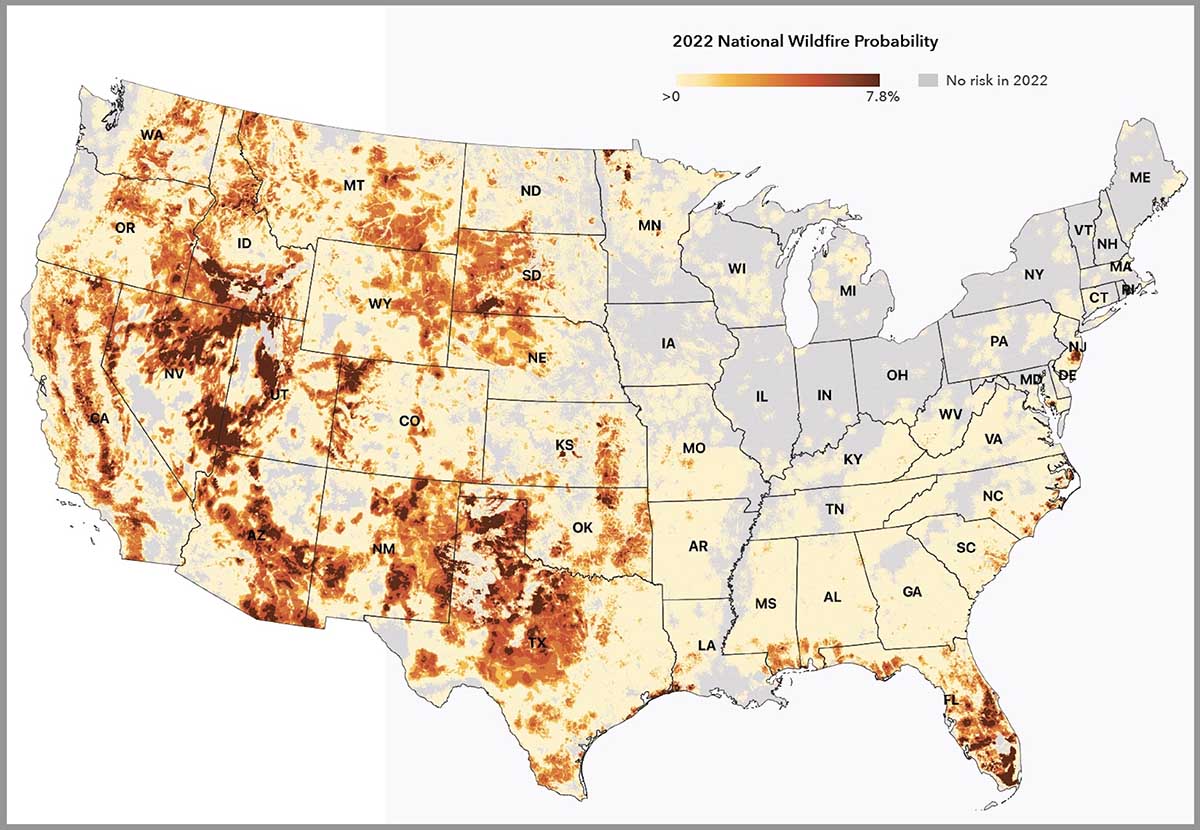
An organization has developed a system for calculating the wildfire risk of 145 million properties this year and 30 years from now.
The First Street Foundation’s Risk Factor is a free source of probabilistic wildfire risk information where anyone can enter a street address and within seconds see the risk for both wildfires and floods at that location.
We tested the system by entering property addresses for two locations that were severely impacted by recent wildfires.
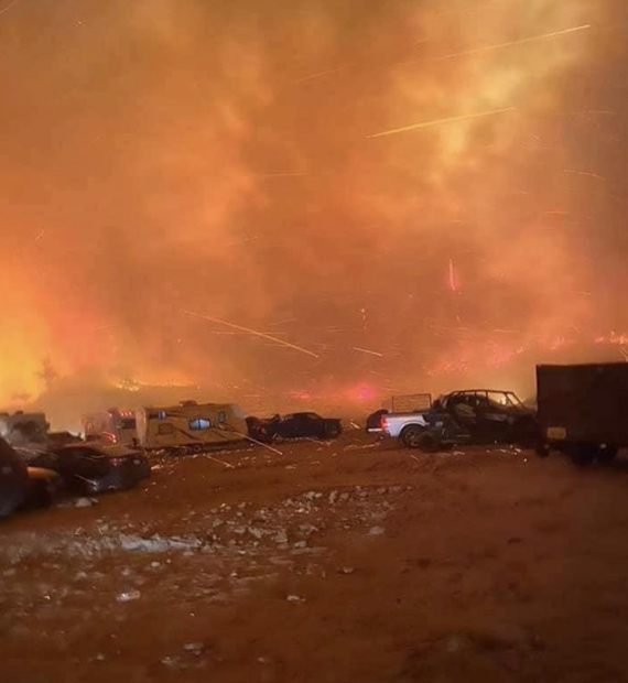
- The Marshall Fire near Boulder, Colorado last year destroyed 1,091 homes and damaged 179. We looked up the Risk Factor for three properties in a community that had total destruction. The result was that they all had a 3 of 10 “moderate fire factor”, and individually a 1.84, 2.0, 1.84 percent chance of being in a wildfire over the next 30 years.
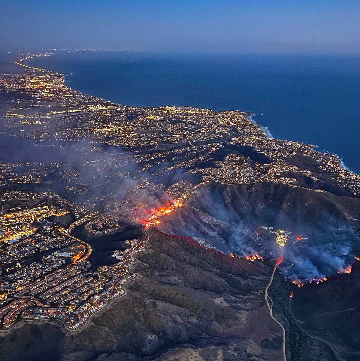
- The Coastal Fire (see photo below) destroyed 20 homes last week in Laguna Niguel, California and damaged 11. The two we looked at in the zone with severe destruction received a 3 of 10 “moderate fire factor” with a 0.93 and 1.54 percent chance of being in a wildfire over the next 30 years. The homes were at the top of a steep brush-covered slope.
The text below is how the First Street Foundation describes their rating system for wildfire risk:
There has long been an urgent need for accurate, property-level, publicly available environmental risk information in the United States based on open source, peer reviewed science. In a mission to fill that need, First Street Foundation has built a team of leading modelers, researchers, and data scientists to develop the first comprehensive, publicly available risk models in the United States. Beginning with flood and now wildfire, First Street works to correct the asymmetry of information in the market, empowering Americans to protect their most valuable asset–their home while working with industry and government entities to inform them of their risk.
METHODOLOGICAL OVERVIEW
The First Street Foundation Wildfire Model integrates information on fuels, wildfire weather, and ignition into a Fire Behavior Model. The wildfire model requires data on the combustible fuels which may contribute to wildfire across the United States. The 2016 update, Version 2.0.0, of the canonical U.S. Forest Service (USFS) LANDFIRE (LANDFIRE, 2021) fuels dataset at the 30 meter resolution serves as a baseline of this fuels estimate, and that dataset is updated by including additional information of all known “disturbances” between 2016 and 2020 which could modify or change the fuels in a way not captured in the original dataset. These “disturbances” include activities such as recent wildfires, prescribed burns, harvests, and other forest management practices.
Another important and novel update included in the First Street Foundation Wildfire model is the reclassification of homes and other buildings from a “nonburnable” fuel type to a “burnable” fuel type. Typically, homes and other buildings are classified as nonburnable fuel types within LANDFIRE v2.0.0. In order to allow the wildfire behavior model to more accurately estimate how wildfire moves through the Wildland-Urban-Interface (WUI), properties within the WUI must be replaced by a burnable fuel type so as to not block the modeled wildfire spread.
To represent a wide range of possible weather-driven wildfire conditions across the landscape within the simulations employed here, the model utilizes a decade of NOAA weather data, the 2011-2020 Real Time Mesoscale Analysis (RTMA) dataset (NOAA/NCEP, 2022) augmented by data from Oregon State’s PRISM dataset (Parameter-elevation Regressions on Independent Slopes Model; PRISM, 2021).
These weather data include hourly surface wind, air temperature, relative humidity, and precipitation information at the 2.5 km horizontal resolution. This weather data supports a wide range of possible weather conditions, not to recreate any particular wildfire events, but to drive the wildfire behavior model millions of times in a Monte Carlo simulation scheme to derive 2022 wildfire hazard estimates.
Similarly, for 2052 the same weather time series was used to drive the simulations, but the air temperature, humidity, and precipitation were bias-adjusted to 2052 conditions following the CMIP5 RCP4.5 ensemble results. Rather than applying a bias-adjustment to the wind time series for the future climate, the same winds from the 2011-2020 time series were used to drive the 2052 simulations to reduce sensitivity of the model to highly uncertain future predictions of winds.
One of the primary indicators of where future wildfires will occur is informed through data on historical wildfire occurrences. These historical wildfires help to inform where wildfires may occur vis-à-vis the Fire Occurrence Database (FOD) developed by the USDA Forest Service (Short, 2014; Short, 2021). An open source wildfire behavior model was used, ELMFIRE (Eulerian Level Set Model of Fire Spread). This work does not develop new techniques for wildfire modeling, but rather implements computationally efficient and scalable modeling techniques at a high resolution based on existing science, wildfire probability, and hazard modeling paradigms. These scalable techniques make it practical to more easily conduct wildfire simulations at the 30 meter resolution across the entire country, enabling property and building specific assessments of wildfire risk.
For each 30 meter pixel across the country, information is recorded on the distribution and occurrence of burn incidence, flame lengths experienced, and the relative amount of embers which land in the pixel. These provide estimates of:
Burn probability: the estimated likelihood of the area burning during any single year.
–Fire intensity: estimated flame lengths, including maximum, average, and sum of all flame lengths experienced.
–Ember exposure: the relative amount of embers which land in an area due to nearby simulated wildfires.


