Rankin Fire burns hundreds of acres in Wind Cave NP

Above: Firefighters conduct a burnout operation on the Rankin Fire in Wind Cave National Park, September 12, 2017. NPS photo.

(UPDATED at 6:34 a.m. MDT September 12, 2017)

A thunderstorm Tuesday afternoon prevented the acquisition of updated satellite mapping information about the Rankin Fire during the regular afternoon overflight, but during the next pass at 2:14 a.m. MDT Wednesday the clouds had dispersed.

For the most current information on Wildfire Today about the Rankin Fire, click HERE.

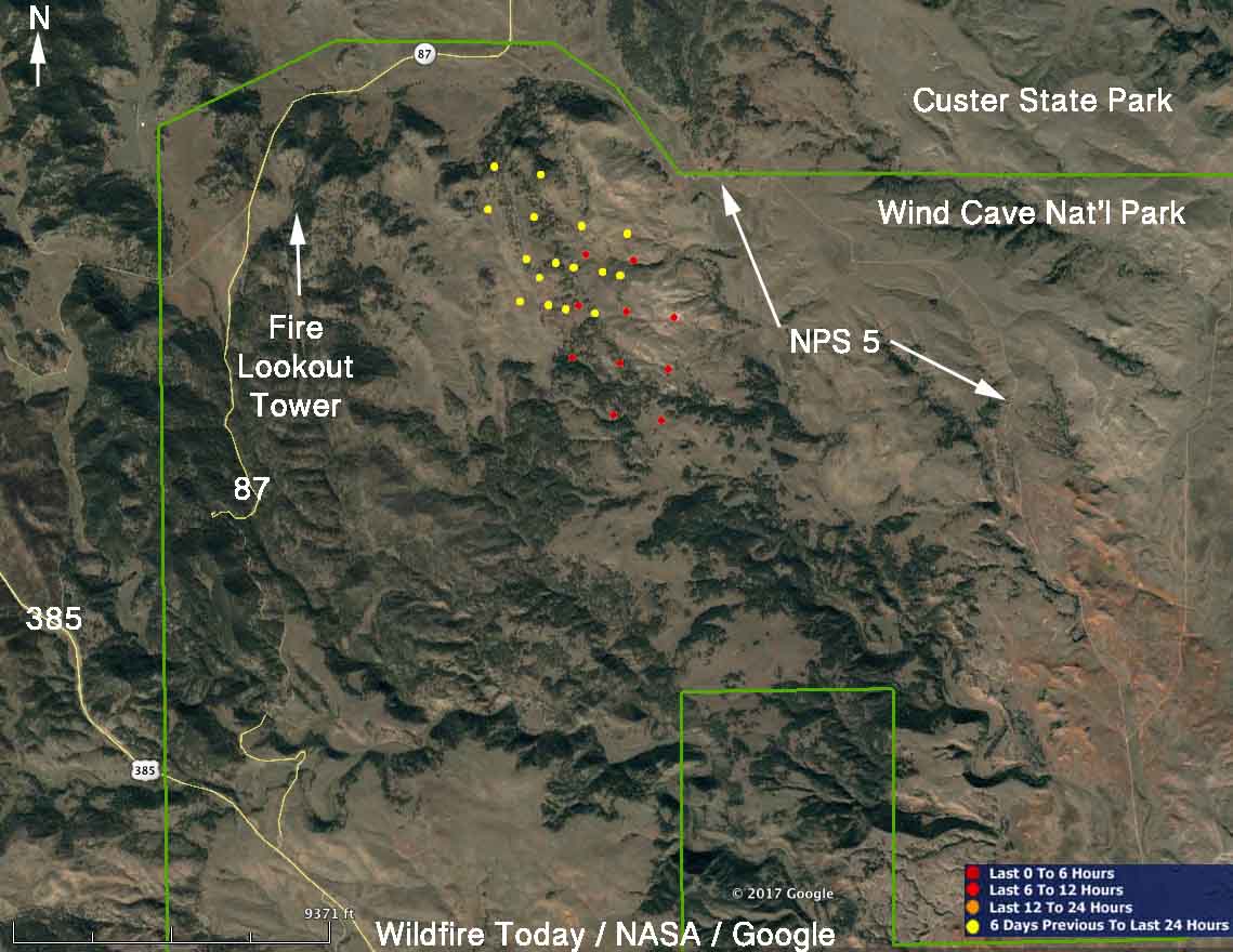
The map below shows additional fire spread detected by the satellite to the south.
map Rankin Fire
The red and yellow dots represent heat detected on the Rankin Fire by a satellite. The red dots are the most current, seen at 2:14 a.m. MDT September 13, 2017. Areas with light vegetation, such as grass, may have burned and completely cooled before the satellite overflight, so the fire may be significantly larger than shown here.

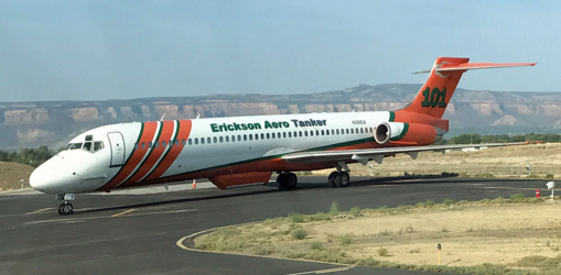
There was a report that air tanker 101, an MD-87, was dispatched from Grand Junction to the fire on Tuesday.
 air tanker 101 MD-87
Air tanker 101, an MD-87, at Grand Junction, Colorado September 8, 2017. Photo by Dave Perkins.

The thunderstorm Tuesday afternoon brought strong winds to the fire area, that no doubt challenged firefighters who were attempting to limit the spread. The winds measured at Elk Mountain south of the fire were from various directions at 8 to 24 mph with gusts of 24 to 44 mph. When the storm passed over the fire the temperature dropped 15 degrees within an hour, from 95 to 80 and the relative humidity increased temporarily from 16 to 29 percent, but within three hours dropped back to 21 percent.

A weather station at Mount Rushmore, 17 miles north of the Rankin Fire, recorded 0.02″ of rain Tuesday afternoon, but there was none at Elk Mountain.

****

(UPDATED at 9:30 p.m. MDT September 12, 2017)

The Rocky Mountain Coordination Center reports that the lightning-caused Rankin Fire in Wind Cave National Park in southwest South Dakota has burned 760 acres.

Monday night and Tuesday firefighters conducted burning operations from a mowed line, NPS 5, and trails to help secure portions of the perimeter.

Gusty winds from a slow-moving thunderstorm cell on Tuesday caused the wind to shift from the south to the north, sending smoke into Hot Springs during the afternoon.

The fire is east of Rankin Ridge fire lookout tower between Highway 87 and NPS 5. (NPS 5 is the dirt road running generally north-south that connects Highway 87 with the 7-11/101 road south of the park.

A Type 3 Incident Management Team has assumed command of the fire.

Currently the only closures in Wind Cave National Park are the northern segment of NPS 5 and all backcountry hiking trails north of Wind Cave Canyon. The park visitor center remains open with cave tours leaving from 9 a.m. to 4:30 p.m. throughout the day.

****

(Updated at 12:07 p.m. MDT September 12, 2017)

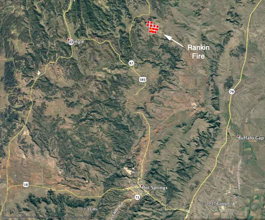
Here’s a map showing the location of the Rankin Fire in Wind Cave National Park as of 2:37 a.m. on Tuesday. The red squares represent heat detected at the fire by a satellite.
map rankin fire
The red squares represent heat detected by a satellite at 2:37 a.m. MDT September 1, 2017.

The Rankin Fire has burned approximately 300 acres as of Tuesday morning.

Monday night firefighters burned out from Hwy. 87 and NPS 5.

At noon on Tuesday the resources assigned to the fire, in addition to numerous fire engines, are one National Guard Blackhawk helicopter, one Air Attack, and a Single Engine Air Tanker is ordered.

Very little information about the fire is being made available.

****


(Updated at published at 9:25 p.m. MDT September 11, 2017)

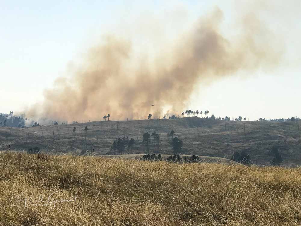
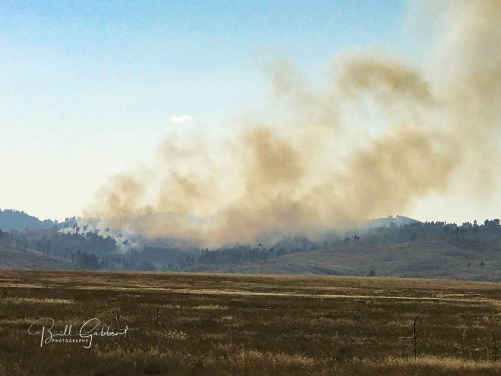
A small thunderstorm passing over the southern Black Hills Sunday night left a souvenir that was discovered around 2 p.m. Monday. The Rankin Fire, caused by lightning, is burning near the Ridge and Lookout Tower of the same name, in Wind Cave National Park in South Dakota.
Rankin Fire south dakota
Rankin Fire, 4:51 p.m. MDT September 11, 2017. Photo by Bill Gabbert.

Spokesperson Kelsey Bean told us at 7:25 p.m. Monday that the fire had burned approximately 20 to 30 acres and no large air tankers had been used so far at that point, but a National Guard Blackhawk helicopter and two single engine air tankers (SEATs) assisted firefighters on the ground. The SEATs came from Casper and Cody, Wyoming.

Nine fire engines from state and federal agencies were on scene this evening and more had been ordered, Ms. Bean said.

We will update this article as more information becomes available.
Rankin Fire south dakota
Rankin Fire, 4:57 p.m. MDT September 11, 2017. Photo by Bill Gabbert.

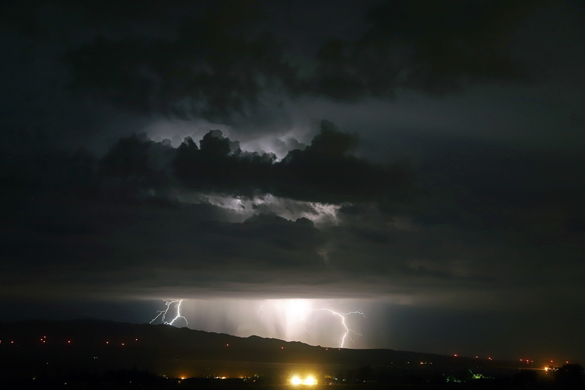
Southern California lightning

(Originally published at 1:33 p.m. MDT September 11, 2017)

Jeff Zimmerman took these photos September 10 and sent them to us today. Here is how he described the event.

From the deserts to the sea, a wonderful display of lightning. Off the coast near Avalon where hundreds of strikes were recorded with numerous strikes all the way to Tehachapi Mountains. Tejon Ranch and Highway 58 area was bathed in lightning too. A new fire was reported on the Los Padres National Forest, lightning strike near Chuchapate (Sawmill). Possibly a few more isolated storms today, followed by gusty NW winds later this week. The first Santa Ana may set up when snow comes to Montana and offshore flow begins later this week bringing critical fire weather with it. Attached are a few shots from the desert in Neenach, CA (map).

lightning Jeff Zimmerman

lightning Jeff Zimmerman

Thanks Jeff!

Never Forgotten

Have you thanked a firefighter today?

never forgotten 9/11While we are remembering the thousands who died on 9/11, don’t forget the emergency workers who perished that day:

  • 343 firefighters (including a chaplain and two paramedics) of the New York City Fire Department (FDNY);
  • 37 police officers of the Port Authority of New York and New Jersey Police Department;
  • 23 police officers of the New York City Police Department NYPD;
  • 8 emergency medical technicians and paramedics from private emergency medical services;
  • 1 Patrolman from the New York Fire Patrol.

Today there are over 20,000 wildland firefighters deployed on fires in the United States. Here are a few of them who are working with members of the military assigned to fires in Washington:

Wildfires persist in the Cascades and Northern Rockies

Today there are 71 large uncontained wildfires in the United States.

Above: the red and orange dots on the map represent heat on wildfires detected by a satellite in the 24 hours before 7:30 a.m. MDT September 11, 2017. Heat found before that is not shown.

(Originally published at 7:45 a.m. MDT September 11, 2017)

In spite of the hurricanes impacting the southeast United States, the wildfires in the Cascade Range and the Northern Rockies persevere in Montana, Idaho, Oregon, Washington, and Northern California.

Off and on over the last week they have slowed as clouds and even some scattered very light showers passed over the areas, but the National Interagency Fire Center reported today there are 71 active large fires, 32 that are being suppressed and 39 that are being suppressed only where needed to protect property.

So far this year 8.2 million acres have burned in the United States, which is 46 percent higher than the 5.6 million average to this date.

Red Flag Warning Northwest Montana
Red Flag Warning for Northwest Montana, September 11, 2017. There is a Fire Weather Watch due to “abundant lightning on dry fuels” predicted Tuesday afternoon for areas in northern California and south-central Oregon.

The weather for Monday and Tuesday could be conducive to fire growth, especially in Northwest Montana where a Red Flag Warning is in effect Monday. But Wednesday through Saturday will bring a chance of rain to Idaho and Western Montana, while the forecast for Northern California, Oregon, and Washington looks dry this week.

Weather forecast Wednesday September 13
Weather forecast for Wednesday September 13, 2017. Weather.com

Wildfire smoke Sunday, and a forecast for Monday

Posted on Categories Uncategorized

Above: The map shows the distribution of smoke from wildfires at 3:54 p.m. MDT September 10, 2017.

(Originally published at 5:45 p.m. MDT September 10, 2017)

The map above shows the distribution of wildfire smoke Sunday afternoon. Below are two different forecasts for Monday.

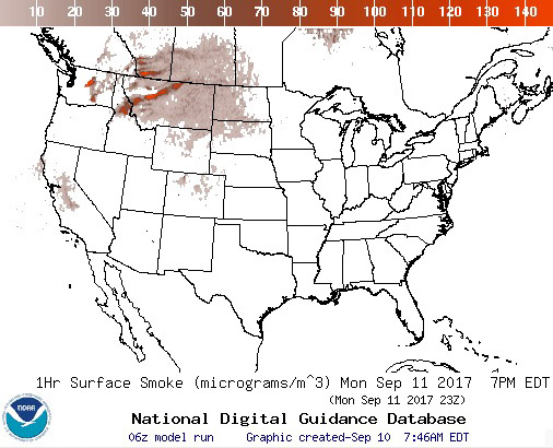
smoke map September 11, 2017 wildfire
This a forecast for the distribution of smoke from wildfires at 5 p.m. MDT September 11, 2017. NOAA.
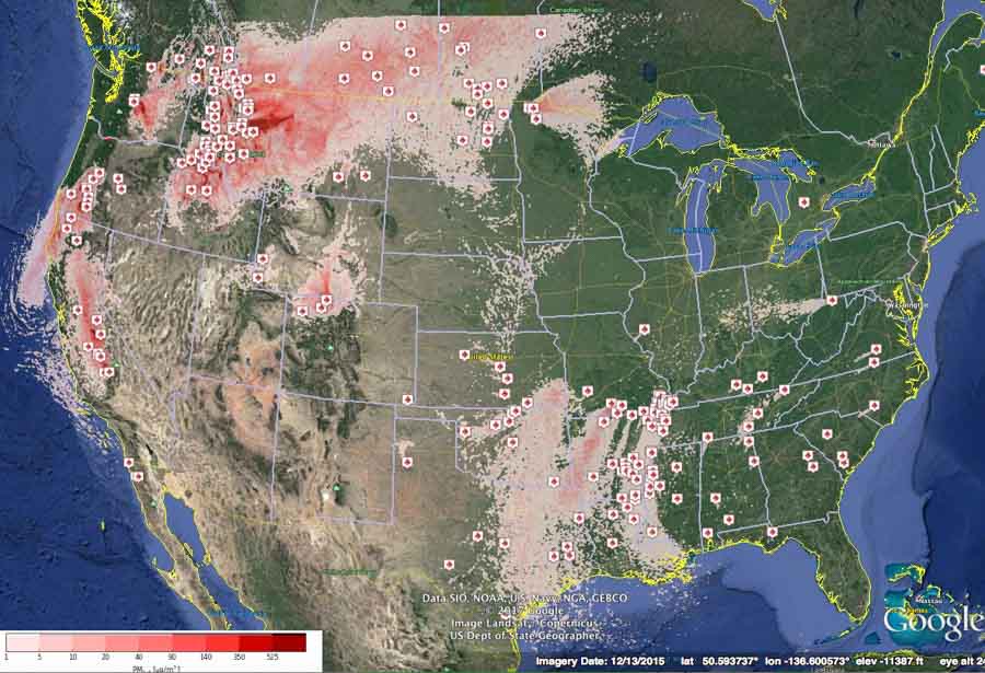
smoke map September 11, 2017 wildfire
This a forecast for the distribution of smoke from wildfires at 1 p.m. MDT September 11, 2017. (Good luck figuring out the nine shades of red in the legend.) BlueSky.

Clouds and high humidity affect Eagle Creek fire in Columbia River Gorge

Mapping flights the last two days were cancelled due to low clouds.

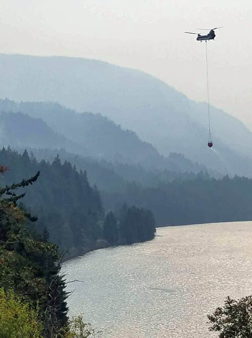
helicopter eagle creek fire columbia river
A helicopter carries water from the Columbia River to the Eagle Creek Fire September 8, 2017. Inciweb photo.

The growth of the Eagle Creek wildfire burning along the Columbia River in northern Oregon 11 miles northeast of Gresham has slowed during the last two days due to cooler and more humid weather. On Friday the relative humidity at Cascade Locks never got below 64 percent. A couple of weather stations just south of the fire recorded small amounts of rain early Saturday morning.

The forecast for calls for a 17 to 30 percent chance of showers through Saturday night, but warmer and drier conditions will prevail Sunday through Tuesday.

Strong winds out of the west at 15 gusting to 25 mph are expected Saturday, but the humidity will remain above 90 percent.

The information below is from the Incident Management Team at about 11 a.m. PDT September 9:

Winds shifted Friday, blowing predominantly upriver out of the west and increasing fire activity to the east. Two new Level 1 (Ready) Evacuation Notices were issued by the Hood River Sheriff’s Department for portions of Hood River County on Friday afternoon.

Firefighters performed a strategic burnout near Cascade Locks to protected endangered residential and commercial structures. They continued to work along Interstate 84 and Hwy 30 using heavy equipment to strengthen firelines and protect structures, avoiding sensitive areas like fish hatcheries. Helicopters were dipping water out of the Columbia River to assist firefighters working south of the Interstate. Helicopters also provided assistance to crews working to contain the Archer Fire in Washington. Overnight, Oregon State Fire Marshall (OSFM) structure protection crews continued to mop up along I-84 and in Corbett while burnout operations were held on the east end. Due to increased moisture in the air and no substantial wind, the fire perimeter remained mostly unchanged overnight.

Weather conditions are expected to be favorable for firefighting activities today with lower temperatures, higher humidity and lighter winds. Activities today will emphasize protecting structures along Interstate 84 and Hwy 30.

OSFM crews will continue to support burnout operations. They will be completing patrols to extinguish hot spots to the east and maintain containment lines in Cascade Locks. All aircraft are available for use today. Firefighters will be scouting on the eastern side of the fire in Hood River County for natural barriers like roads and trails to create a line of defense for homes the in that area. Preparations are underway for a strategic burnout to protect the community of Corbett on the fire’s western edge, however that burnout may be delayed due to the moist conditions expected today. All firefighting efforts are aimed at restoring normal activities along the Columbia River and the Interstate 84/Hwy 30 corridor.

While today’s weather is giving firefighters a bit of breathing room, conditions in upcoming days will revert to drier, windier conditions. As always firefighter and public safety are the primary objective while fighting the Eagle Creek Fire.

Resources Assigned: 4 Type 1 (Hotshot) crews, 11 Type 2 crews and 5 Type 2 Initial Attack Crews; 104 Engines; 12 helicopters; 987 Personnel