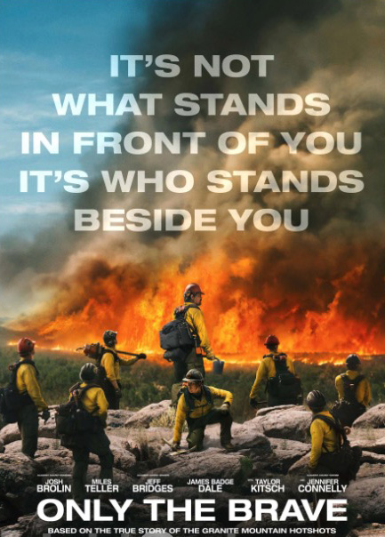
New movie poster for “Only the Brave”


only the brave
“Only the Brave” opens in theaters October 20, 2017.

In about seven weeks the new movie “based on the true story of the Granite Mountain Hotshots” will be in theaters. In 2013, 19 members of the crew were entrapped and killed on the Yarnell Hill Fire south of Prescott, Arizona.

Not many many movies have been built around wildland firefighters. There was Red Skies of Montana that in 1952 introduced the myth of exploding trees, and Firestorm brought us Howie Long in 1998. Always was a good movie, but it was not really about wildland fire. So, many of us will be skeptical while waiting for Only the Brave to open on October 20.

However, there are reasons to be optimistic. Black Label Media which produced the film also made the award winning La La Land (Golden Globe Best Picture, Musical or Comedy), a story that could not be more different from Only the Brave, but it at least indicates that skilled personnel are employed by the company.

Molly Smith, an executive with Black Label, said it’s the film she’s most proud of. On her Instagram page she wrote:

We hope you feel, when you see it, as patriotic and proud as we have to have some of the greatest firefighters in the world constantly putting themselves out there for our well being. The ones who have lost their lives we honor respectfully every day, and the ones who wake up covered with dirt and ash and stale coffee on their breath (and always a ribbing laughter) we salute you again and again and again. I hope you feel we have represented you well.

The film has quite a few well-known actors, including Josh Brolin (plays Eric Marsh), Jeff Bridges (Duane Steinbrink), Jennifer Connelly (Amanda Marsh), Andie McDowell, Miles Teller (Brendan McDonough), and James Badge Dale.

In an Entertainment Weekly interview, Mr. Brolin, who for a while was a volunteer firefighter in Arizona, talked about how the actors in the movie still maintain regular contact:

This was different, probably because of the subject matter. Nobody’s willing to let it go.

Wildfire activity continues in northwest California and southwest Oregon

Oregon’s Chetco Bar Fire has exceeded 100,000 acres

Above: Firefighters on structure protection duty set up a sprinkler system on the Chetco Bar Fire in Southwest Oregon. Undated photo on Inciweb.

(Originally published at 9:03 a.m. PDT August 24, 2017)

The wildfires in Southwest Oregon and Northwest California continue to grow at a fairly steady pace, with occasional large expansions during wind events.

The Chetco Bar Fire five miles northeast of Brookings, Oregon was mapped very early Thursday morning at 102,333 acres, moving past the 100,000-acre threshold into “megafire” territory. But it is still one-fifth the size of the Biscuit Fire that covered almost half a million acres in the same general area in 2002.

The red line was the perimeter of the Chetco Bar Fire at 12:16 a.m. PDT August 24, 2017. The white line was the perimeter two days before.

The map of the Chetco Bar Fire shows that while it continues to spread along much of the perimeter that growth has slowed since it quadrupled in size over a four-day period, August 18 to 22. It added 2,389 acres on Wednesday through minimal flanking, backing, and creeping fire behavior due to cooler temperatures and higher humidities.

More fighters have poured in to the Brookings, Oregon area which is five miles southwest of the fire. Over 1,100 personnel are now working on the blaze, including 21 hand crews, 118 engines, and 8 helicopters. The incident management teams report that 25 structures have burned.

Three teams are assigned to the Chetco Bar Fire: Livingston’s Type 1 team, Greer’s Type 2 team, and Houseman’s National Incident Management Organization (NIMO) team. (The NIMO folks need to come up with a better name for their teams.)

wildfires in southwest Oregon and Northwest California
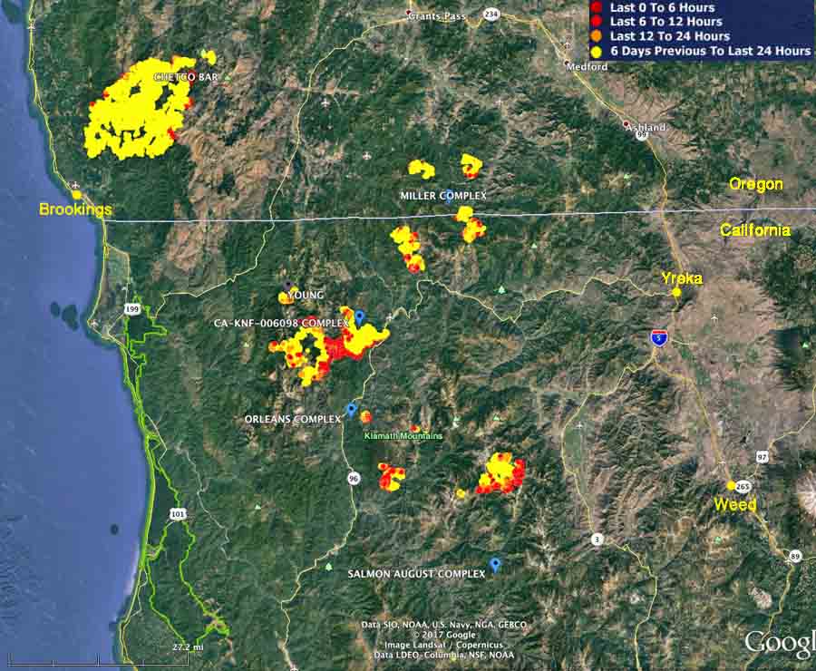
The red, brown, and yellow dots represent heat detected only within the last week on wildfires in southwest Oregon and Northwest California.

The fires in Northwest California do not receive much press coverage since they are in remote, sparsely populated areas. The largest is the Eclipse Complex of five fires 10 miles north of Happy Camp which has burned 40,500 acres. It is also known as “CA-KNF-006098 Complex”. On Wednesday the inversion that had been moderating fire behavior lifted over one of the five fires, the Prescott Fire, which became active and burned towards the Oak Fire. This produced a large smoke column that caused ash fall along the Hwy 96 corridor and throughout the Happy Camp area.

Toll and Squirrel Fires
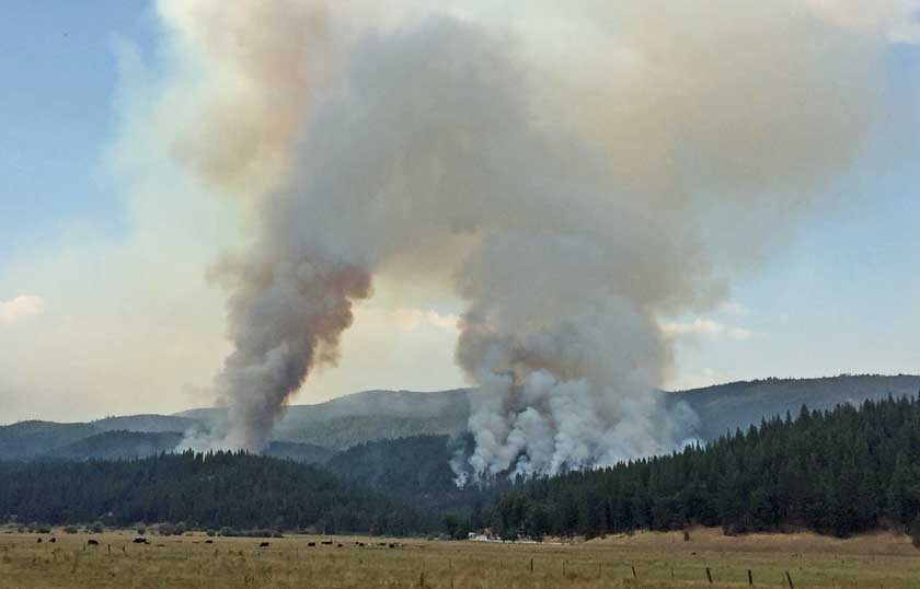
The Toll and Squirrel Fires are not in Northwest California, but are near Quincy, California. August 20, 2017. Inciweb.

In other wildfire news, the Secretaries of the Interior and Agriculture are visiting Missoula and the Lolo Peak Fire today (August 24), accompanied by the USFS National Fire Director, Shawna Legarza.

Continue reading “Wildfire activity continues in northwest California and southwest Oregon”

Wildfire smoke map, August 23, 2017

The map shows the distribution of smoke from wildfires at 12:51 p.m. MDT August 23, 2017. You can’t read the labels, but large fires are tagged on the map.

Smoke from wildfires in Canada has reached the UK:

And other areas in Europe:

A magic trick, or a peat fire?

This almost looks like a magic trick, but it shows what can happen with very deep-seated fires, such as peat. Smouldering underground with limited oxygen, the very hot material and gasses can transition into flaming combustion once introduced to an atmosphere with a higher concentration of oxygen.

Mesmerizing.

“Let’s be careful out there”.

Three Idaho firefighters injured when gas can falls off truck and ignites

Three firefighters with the Downey Fire Department in southeast Idaho (map) were injured when a gas can fell off their truck while fighting a vegetation fire. They were backing at the time and one of the tires on the five-ton, 6×6 truck ran over the can. The spilled gas ignited from an ember in the burned over area where they were at the time. The intense fire that developed burned all three firefighters, one of them over 40 percent of his body.

All three were transported to a hospital and two were transferred to the University of Utah Burn Center in Salt Lake City where a spokesperson said one was in critical condition and another was in serious condition. The third was treated and released. One of them also suffered a broken leg.

The truck was destroyed and the fire was knocked down after it spread to six acres.

Updated satellite photo of wildfires in Western Montana and Northern Idaho

Above: Satellite photo of smoke from fires in Western Montana and Northern Idaho, August 22, 2017. The red dots represent heat detected by a satellite.

(Originally published at 3:03 p.m. MDT August 22, 2017)

It has been many days since we were able to find a satellite photo free of clouds enough to see smoke from the wildfires in Western Montana and Northern Idaho, but today there were few clouds in the area. This photo from Tuesday afternoon shows less heat (the red dots) than what we were seeing one to two weeks ago.