Washington: Hot Shot & Proctor Creek Fires

(UPDATED at 9:15 a.m. PDT May 15, 2016)

The Washington Department of Natural Resources reports that the Hot Shot Fire has been mapped at 67 acres.

The Proctor Creek Fire has burned 352 acres and the evacuation levels have “eased”, according to the DNR. Northwest incident management team #10 is managing both fires.

Rain on both fires Saturday afternoon slowed the spread of the fires.

This will be the last report on these fires unless there is a major change in conditions.

****

(Originally published at 9 a.m. PDT May 14, 2016)

Two fires in northwest Washington have burned over 100 acres each, and one required evacuations.

The Proctor Creek Fire three miles south of Gold Bar has burned approximately 150 acres since it started on May 13. KPQ reported that residents in Big Bend were ordered to evacuate. A Type 3 incident management team is scheduled to assume command on Saturday.

The Hot Shot Fire got its name from the timber sale in which its burning. The 135-acre fire is in Snohomish County off Highway 530 near Oso.

map Hot Shot and Proctor Creek Fires
Hot Shot and Proctor Creek Fires in northwest Washington.

Using a dozer to mop up a structure fire

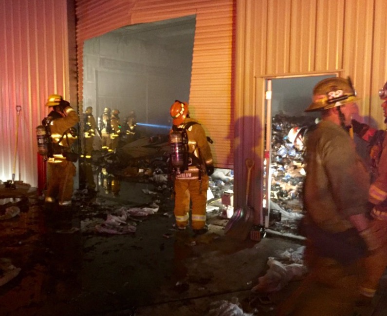
Dozers are commonly used on vegetation fires, but it is unusual to see them at a structure fire. In the video above, Los Angeles County Fire Department used a dozer to assist firefighters during the overhaul or mop up stage of a structure fire in Lancaster, California Thursday night. Apparently there was a large quantity of material inside the commercial building that would have been difficult to completely extinguish without spreading out the burning debris. It looks like they were using foam or a wetting agent in the water to achieve greater penetration.

Lancaster structure fire
Commercial building fire in Lancaster, California. Via @LACoFDPIO

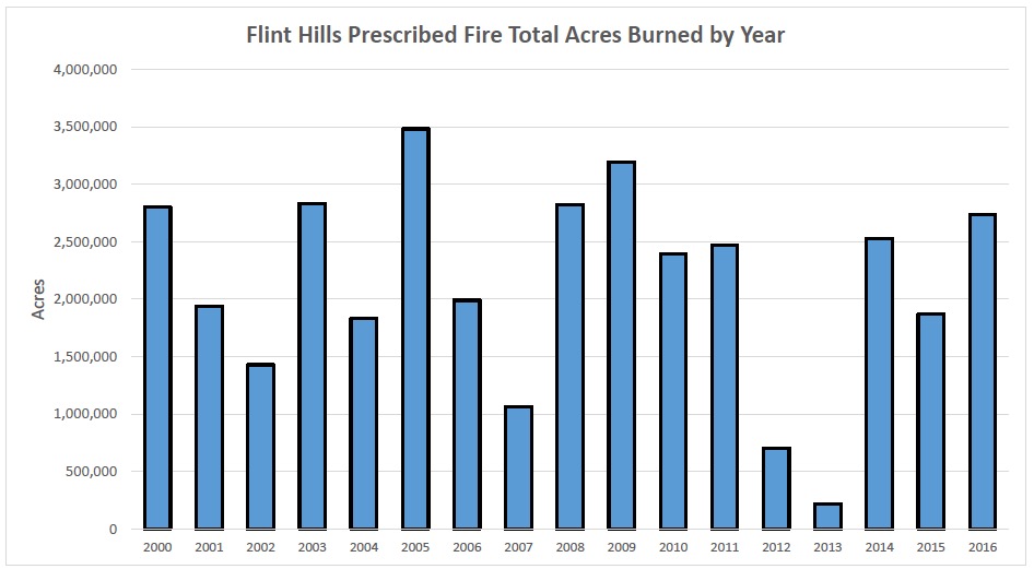
2.7 million acres burned in prescribed fires this spring in the Flint Hills

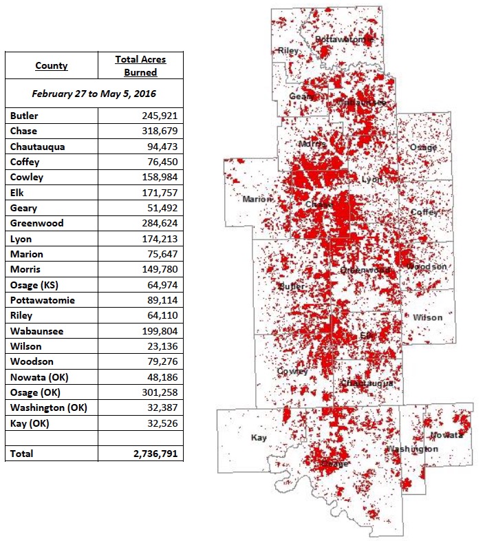
In February we posted some statistics showing that historically there is a large spike in wildfire activity in March and April in Kansas. The spring is also a time when many, many ranchers conduct prescribed fires in the Flint Hills of Kansas and Oklahoma. This year between February 27 and May 5, 2.7 million acres were treated with prescribed fire.

Referring to the bar graph below, and throwing out the two busiest and the two slowest data points, in a typical year land managers in the Flint Hills burn between 1.1 million and 2.8 million acres.

Flint Hills Rx fire acreages 2000-2016


Flint Hills, 2016 Rx fire acres

We thank Eric Ward of the Kansas Forest Service for providing these graphics compiled by the Kansas Department of Health and Environment..

Tagged articles on Wildfire Today about fire in the Flint Hills of Kansas and Oklahoma.

Synthesis of knowledge of extreme fire behavior, volume 2

Volumes 1 and 2 are available as electronic copies or in print.

Synthesis knowledge extreme wildfire behaviorThe Synthesis of knowledge of extreme fire behavior: volume 2 for fire behavior specialists, researchers, and meteorologists, released this year, is now available in print form. It can be downloaded as a .pdf or ordered in hard copy.

It followed Volume 1, released in 2011, which was directed toward fire managers. It is also available as a .pdf or hard copy.

Here is how the 13 authors described the project:

…No one completely understands all the factors contributing to extreme fire behavior because of gaps in our knowledge. These gaps, as well as the limitations as to when various models or indices apply should be noted to avoid application where they are not appropriate or warranted. This synthesis summarizes existing extreme fire behavior knowledge. It consists of two volumes. Volume 1 is for fire managers, firefighters, and others in the fire community who are not experts or specialists in fire behavior but need to understand the basics of extreme fire behavior. Volume 2 is more technical and is intended for fire behaviorists and fire researchers.

The objective of this project is to synthesize existing extreme fire behavior knowledge in a way that connects the weather, fuel, and topographic factors that contribute to development of extreme fire behavior. This synthesis focuses on the state of the science but also considers how that science is currently presented to the fire management community, including incident commanders, fire behavior analysts, incident meteorologists, National Weather Service office forecasters, and firefighters. The synthesis seeks to delineate the known, the unknown, and areas of research with the greatest potential impact on firefighter protection.


Smoke mixes with clouds in Alberta

smoke - clouds Alberta
Photo: NOAA/NASA

The photo shows smoke from the huge fire at Fort McMurray, Alberta mixing with clouds. The image was acquired Monday May 9 by the Suomi National Polar-orbiting Partnership satellite and NASA’s Aqua satellite.

To see the most current smoke reports on Wildfire Today, visit the articles tagged “smoke” at https://wildfiretoday.com/tag/smoke/

NIFC mobilizes air tankers to assist Canada

Posted on Categories UncategorizedTags , ,
A BAe-146 air tanker dropping on a recent wildfire in Canada.
A BAe-146 air tanker dropping on the Kenora #18 Fire in Canada. Photo by Chris Sherwin.

This article was first published on Fire Aviation.

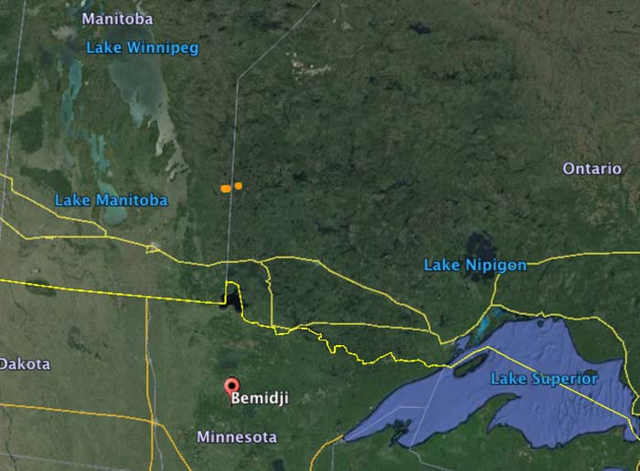
The National Interagency Fire Center has mobilized two BAe-146 air tankers and one King Air lead plane to assist the Canadian provinces of Ontario and Manitoba. Tankers 10 and 41 will be working out of the air tanker base at Bemidji, Minnesota 86 miles south of the US/Canadian border.

The aircraft were ordered primarily for the Kenora #18 Fire that straddles the border between Manitoba and Ontario (the brown dots in the map below). But they could be used for fires in either province.

According to the U.S. National Interagency Fire Center, Canada has not requested U.S. assistance specifically for wildfires in Alberta. The aid, they said, was requested through a bilateral firefighting assistance agreement with the Canadian Interagency Fire Center (CIFC). At this time, Canada has not requested additional resources or assistance from the U.S., though NIFC and the CIFC are frequently communicating.

Map Ontario Manitoba US