McKinney Fire prompts evacuations northwest of Yreka, CA

Updated 5:58 p.m. PDT July 31, 2022

The AlertWildfire camera in Northern California on Herd Peak recorded the effect of what is likely outflow winds from a thunderstorm affecting smoke from the McKenney Fire. At the time on Sunday afternoon July 31, 2022 it had burned about 52,000 acres northwest of Yreka. It appears that the fire is spreading across the ground, but most likely it is just smoke.

To see all articles on Wildfire Today about the McKinney Fire, including the most recent, click HERE.

Rain on the fire
It was very spotty, but some locations on the McKinney Fire received rain Saturday night between 10 p.m. and 3 a.m. Sunday morning. The weather station on Mt. Baldy on the western edge of the fire received just over half an inch, Scott Barr three miles west of the fire got 0.19″, and Oak Knoll off Highway 96 received 0.01″. Several locations near Yreka recorded no precipitation.

There are very few weather stations in or near the fire area, but the National Weather Service produced the map below with estimated precipitation amounts based on radar observations.

rain McKinney Fire
Radar observed precip, for the 24-hour period ending at 5 a.m. PDT July 31, 2022. NWS.

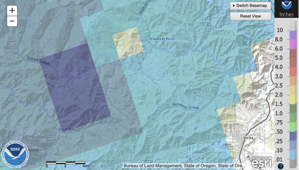
The west side of the fire received the most precipitation, according to the radar, with much less on the east side. The radar data is just an estimate, but it appears possible that a good sized portion of the west side received at least a wetting rain, with much of that side experiencing between 0.10 and 0.50″. If this is the case, the east side should see more fire growth for at least the next day or so than on the west side.

Fire activity
The rain combined with an inversion Saturday evening to slow the fire, but activity increased in some locations around midnight. Crews were actively engaged in structure protection in the Klamath River area. Little progression was observed on the southeast side closest to Yreka.

The McKinney Fire was mapped Sunday afternoon at 52,499 acres. The China 2 Fire 15 miles west of the McKinney Fire has burned 1,652 acres on the south side of Highway 96.

Sunday
Priorities for Sunday are to continue structure preparation and protection in the Highway 96 corridor, and around the communities of Fort Jones and Yreka.

Homes destroyed
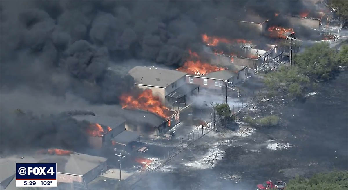
The Siskiyou County Sheriff’s Office has confirmed that several structures have been destroyed. Sheriff’s office Spokeswoman Courtney Kreider said residences along Highway 96 in the Klamath River drainage burned. She did not have a specific number.


Updated at 5:36 a.m. PDT July 31, 2022

McKinney Fire map 3-D
McKinney Fire 3-D map, looking west-southwest at 12:30 a.m. PDT July 31, 2022. The white lines were the perimeter at 5:19 p.m. on July 29.

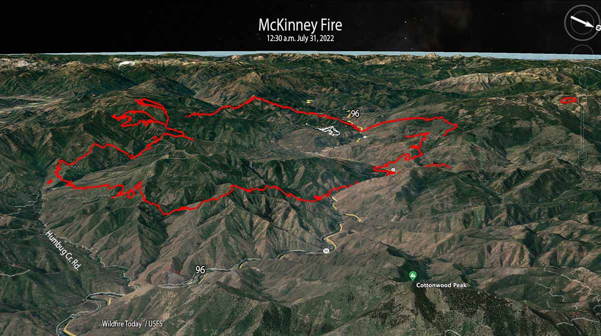
The McKinney Fire in Northern California eight miles south of the Oregon state line was very active throughout the night. When it was mapped by an aircraft at 12:30 a.m. Sunday it had grown to 51,468 acres. During a satellite overflight at 3:38 a.m. about 90 percent of the heat detected was on the east and southeast sides.

This was the only complete mapping of the fire since noon on Saturday due to thunderstorms and lightning in the area which restricted flights of air tankers and helicopters.

McKinney Fire map
McKinney Fire map at 12:30 a.m. PDT July 31, 2022. The white line was the perimeter at 5:19 p.m. on July 29.

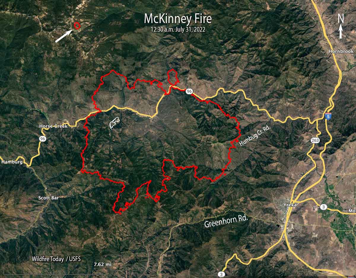
At 12:30 a.m. Sunday it was 5 miles northwest of Yreka, 2 miles north of Greenhorn Road, 5 miles west of Highway 263, 4 miles east of Scott Bar, and 2 miles east of Horse Creek.

The mapping flight found a 75-acre fire burning four miles northwest of the McKinney Fire east of Condrey Mountain. It is unknown at this point if it a new fire or a spot from the McKinney.

Another fire 15 miles west of the McKinney Fire, the China 2 Fire, has burned approximately 1,000 acres south of Highway 96 in the Seiad Valley area.

Weather
Isolated and scattered thunderstorms with little or no rain are predicted for the area on Sunday with gusty outflow winds of 40-50 mph and cloud to ground lightning. Pyrocumulus could regenerate with potential for rapid fire growth and spread. There is a 5 percent chance of wetting rain. The relative humidity will be 15 to 25 percent.


Updated 6:41 p.m. PDT July 30, 2022

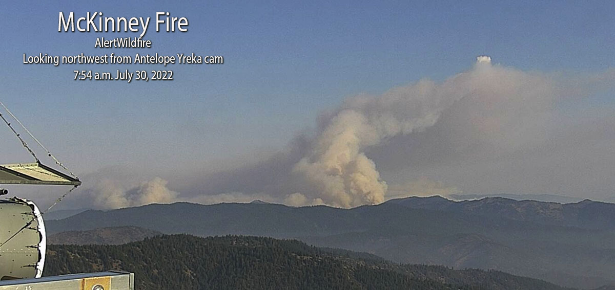
Saturday afternoon the area around the McKenny Fire northwest of Yreka, California was covered by cumulonimbus clouds, thunderstorms with lightning. This made it very difficult for air tankers, helicopters, or mapping aircraft to work over the blaze. Even the AlertWildfire cameras on mountain peaks late in the afternoon could see nothing but smoke. But satellite imagery peeking through breaks in the clouds detected intense heat from the fires.

The video below shows lightning and heat detected by a satellite during a 2-hour period ending at 6:21 p.m. PDT July 30 in Northern California and southwest Oregon. The red areas represent heat from the fires. The white line is the Oregon/California border. The white flashes are lightning.

Evacuations are in effect over a large area, ordered by the Siskiyou County Sheriff. Details can be found on their Facebook page.Zonehaven Aware map is also available.

At 3 p.m. Saturday the US Forest Service estimated the fire had burned 30,000 to 40,000 acres.


Updated 1:20 p.m. PDT July 30, 2022

McKinney Fire map, 12:04 p.m July 30, 2022

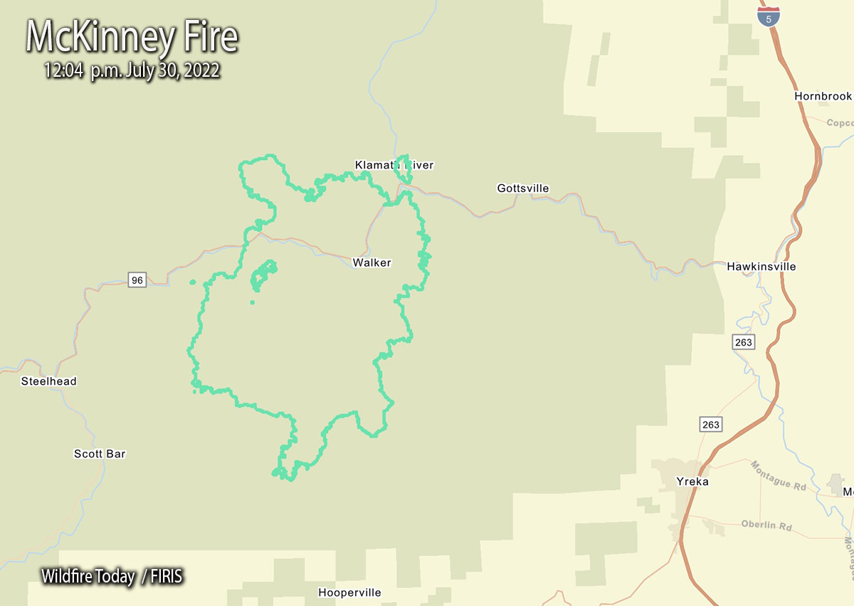
The FIRIS aircraft mapped the McKinney Fire at an astounding 29,493 acres just after noon today. That explosive growth is less than 24 hours after it was reported at 2:15 p.m. Friday. (See map above)

This current map shows us that at 12:04 p.m. Saturday it was 9 miles west-northwest of Yreka, 3 miles northwest of Scott Bar, and 3 miles west of Gottsville.

During its first 22 hours it spread north 4 miles, east 5 miles, south 6 miles, and west about 2 miles.


9:48 a.m. PDT July 30, 2022

McKinney Fire

The McKinney Fire northwest of Yreka, California grew rapidly after it was reported Friday afternoon south of Highway 96 in the Klamath National Forest. Since then it has spread north across the highway and also to the south.  At about 5 a.m. Saturday the Siskiyou County Sheriff said it was approximately four miles from Scott Bar after having been very active all night.

At about 8:45 a.m. on Saturday the Klamath National Forest estimated it had burned approximately 18,000 acres. The most recent perimeter map available is from Friday at 5:19 p.m., when it was only 65 acres. This current estimate from the Forest Service indicates it is 277 times larger. Additional perimeter mapping data was most likely prevented by lightning and thunderstorms in the area.

The fire was 14 miles northwest of Yreka when first reported, but grew closer overnight.

Evacuations are in effect over a large area, ordered by the Siskiyou County Sheriff. Details can be found on their Facebook page.Zonehaven Aware map is also available.

Continue reading “McKinney Fire prompts evacuations northwest of Yreka, CA”

Most of the work still remaining on the Oak Fire is on northeast side

Posted on Categories WildfireTags ,

The fire is east of Mariposa, California

Oak Fire map 9:17 p.m. July 27, 2022
Oak Fire map. The red line was the perimeter at 9:17 p.m. July 27, 2022. The white line was the perimeter about 48 hours before.

Most of the perimeter of the Oak Fire northeast of Mariposa, California was quiet on Wednesday, with the exception of the north and northeast sides where it has continued to spread. Firefighters have constructed firelines in those areas, some of them indirect, and are making progress. It has moved one to two miles into the footprint of the 2018 Ferguson Fire.

To see all articles on Wildfire Today about the Oak Fire, including the most recent, click HERE.

The fire was mapped Wednesday night at 19,169 acres.

The video below was shot by the FIRIS aircraft looking south at the northeast side of the fire at 9:20 p.m. July 27. White indicates heat.

Suspected arsonist captured and tied to tree by locals

Updated at 12:06 p.m. PDT July 27, 2022

mapJ uly 25 arson fires in Southwest Oregon
General area of the July 25 arson fires in Southwest Oregon.

On Monday a Bureau of Land Management employee reported that a man was walking down a road igniting vegetation fires in a remote area about 25 miles northwest of Grants Pass, Oregon.

From the AP:

Ground crews, assisted by local residents, and three helicopters quickly got the two fires under control, Curry County Sheriff John Ward said.

Meanwhile, three local residents located the suspect walking on the road near the fires and detained him.

“It was reported that the suspect became very combative with the three residents and had to be tied to a tree to subdue him.,” Ward said in a statement. “An ambulance crew was asked to respond due to some injuries that the suspect apparently received from falling down.”

Smith was transported to Three Rivers Hospital in Grants Pass and once he was medically cleared, transported by US Forest Service law enforcement to the Curry County Jail and held on Reckless Burning and two counts of First-Degree Arson. There was also a Detention Warrant in effect out of Lane County for probation violation.

Trennon Ray Smith mug shot
Trennon Ray Smith. Lane County Sheriff’s Office.

Moose Fire grows to 37,264 acres

Northwest of Salmon, Idaho

Moose Fire map 10:18 p.m. MDT July 25, 2022
Moose Fire map. The red line was the perimeter at 10:18 p.m. MDT July 25, 2022. The white line was the perimeter about 48 hours before. The brown areas had extreme heat when the fire was mapped.

Most of the growth on the Salmon Fire 10 miles northwest of Salmon, Idaho has been south of the Salmon River in recent days. It was mapped Monday night at 37,264 acres, a 24-hour growth of more than 1,500 acres.

On the east side, fire activity was high in Bobcat Gulch and the Napoleon Hill area in the late afternoon Monday and through the night. Spot fires occurred one mile south of Napoleon Hill as the fire was pushed by winds out of the north. The south side of the fire generally is holding in place with no new growth in the Moose Creek area. The fire is still spreading on the west side south of the river.

On the south side where the strategy is to “confine”, not “contain”, heavy equipment task forces are constructing and reinforcing indirect fire line six to nine miles south of the fire from Morning Glory west to Leesburg, and further west into Panther Creek, then to the Salmon River.

One of these indirect firelines being constructed is five miles south of the southeast corner of the fire, south of Moose Creek Road.

The photos below were taken July 23 by Mike McMillan for the US Forest Service.

Moose Fire Salmon Idaho
Firefighters on the Moose Fire prepare to defend structures along Hwy 93 corridor, July 23, 2022. Photo by Mike McMillan-USFS
Moose Fire Salmon Idaho
Firefighters on the Moose Fire, July 23, 2022. Photo by Mike McMillan-USFS
Moose Fire Salmon Idaho
Moose Fire backs down a slope, July 23, 2022. Photo by Mike McMillan-USFS


Oak Fire slows, but still spreads into footprint of 2018 Ferguson Fire

CAL FIRE is using one of their new Firehawk helicopters to drop water at night

 7:05 a.m. PDT July 26, 2022

Oak Fire map 7:27 p.m. July 25, 2022
Oak Fire map. The red line was the perimeter at 7:27 p.m. July 25, 2022. The white line was the perimeter about 23 hours before.

Fire officials called Monday a successful day on the Oak Fire northwest of Mariposa, California, saying there was minimal growth. The 1,200 acres added paled in comparison to the rapid spread seen on Friday and Saturday. It was mapped Monday night at 18,017 acres, with most of the increase being on the east side where it is chewing through the four-year old vegetation in the footprint of the 2018 Ferguson Fire. East of Jerseydale it has advanced nearly two miles into the fire scar.

To see all articles on Wildfire Today about the Oak Fire, including the most recent, click HERE.

Helicopters dropped 300,000 gallons of water Monday, including thousands of gallons dropped by one of CAL FIRE’s new night-flying helicopters, H-903, normally based at McClellan near Sacramento. According to tracking data recorded by FlightAware it conducted what appeared to be two fuel cycles working out of the Columbia airport 42 miles northwest of the Oak Fire. Until CAL FIRE recently purchased their 12 new Sikorsky S-70i Firehawk helicopters they were not in the night-flying business. This was one of the first fires CAL FIRE has flown at night.

CAL FIRE H-903, Sikorsky S-70i FireHawk
CAL FIRE H-903, Sikorsky S-70i FireHawk, N483DF, Photo by Dylan Phelps, Sept. 2020.

The damage assessment team has been working for the last two days to identify structures affected by the fire. Monday afternoon their findings to date were released — 21 residences and 34 outbuildings have been destroyed.

Resources on the incident Monday night included 24 helicopters, 302 fire engines, 82 dozers, 68 water tenders, and 61 hand crews for a total of 2,991 personnel.

Grass fire burns into Dallas suburb, destroys 9 homes

Another 17 were damaged

11:53 p.m. CDT July 25, 2022

Balch Springs Fire
Grass fire spreads into neighborhood in Balch Springs, Texas, July 25, 2022. Image from video by FOX 4 Dallas-Fort Worth.

A grass fire burned into a suburb of Dallas, Texas Monday afternoon destroying 9 homes and damaging another 17, according to city officials. It occurred in Balch Springs when a mower struck an object in a field, creating a spark which ignited dry grass near Interstate 20 and South Beltline Road.

A steady breeze pushed the fire into a row of houses adjacent to the field. One by one the fire ignited house after house, aided by a fence that ran behind and between all of the homes which contributed to the fuel load and the continuous spread.

Balch Springs Fire
Grass fire spreads into neighborhood in Balch Springs, Texas, July 25, 2022. Image from video by FOX 4 Dallas-Fort Worth.

In the 30-minute video below very few firefighters are seen for the first 20 minutes. Balch Springs, with an estimated population of about 25,000 in 2019 has about eight firefighters working on any given day, Fox 4 news reported. The fire was well established when the video began, with at least one home already burning.

Looking at the video from a firefighter’s perspective, it is interesting to see how the fire progresses as the fence and outbuildings burn intensely, structures ignite, police gather in the street, a dog in a backyard looks worried (at 17:48), and little is seen in the video to initially stop the spread through the field or the neighborhood. However we don’t see the street side of the homes except at the very beginning; there may have been more firefighter activity on that side. There was a tower/ladder truck in the street that looked like it kept about four houses from being destroyed.

Our hearts go out to the residents who lost their homes.