An MD-87 air tanker drops on the Blodgett Peak Fire Dec 22, 2021. Image from video shot by Colorado Springs Fire Department.
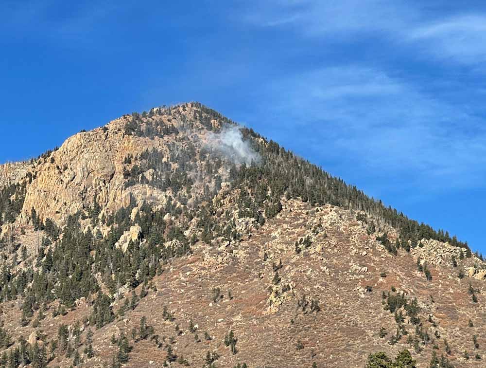
The last entry on the Pike & San Isabel National Forests blog was on October 13, about a 13-acre fire northeast of Gardner, Colorado — until yesterday, Dec. 22, when a fire was reported at 5:22 a.m. about two miles southwest of the Air Force Academy northwest of Colorado Springs. It was near the top of Blodgett Peak, 9,400 feet above sea level.
A person would think that three days before Christmas there would be snow in Colorado at that elevation, but none was visible in photos posted by the Colorado Springs Fire Department. And not only was there no snow, but two large air tankers were on duty and assisted firefighters.
The fire is 0.9 mile inside the National Forest boundary. It was mapped by the state’s multi-mission aircraft Wednesday at 0.3 acre.
Blodgett Peak Fire Dec 22, 2021. Photo by Colorado Springs Fire Department
The area was under a Red Flag Warning Wednesday for predicted winds gusting over 40 mph and very low humidity. Firefighters did not reach the fire Wednesday due to concerns about the wind. The area was patrolled by personnel from the Colorado Springs Fire Department that night, and the incident was turned over at 9 a.m. Thursday to the US Forest Service with a Type 2 hand crew and a Type 3 helicopter.
Ten years ago a slow moving fire on Colorado’s front range, especially in December, would not always have been aggressively attacked. But gradually since the 2012 Waldo Canyon Fire destroyed 344 homes, killed two people, and burned 18,000 acres on the west side of Colorado Springs, federal and local fire agencies have been improving their initial attack strategies.
#BlodgettPeakFire Air tanker drops on the fire successful this afternoon. CSFD brush patrols will be in the area overnight. Active flames may be visible throughout the night, please don’t call 911, we have crews on scene monitoring. Please avoid the area. pic.twitter.com/6swXr0CqxG
Kansas Forest Service reports that the largest blaze burned about 365,000 acres
12:52 p.m. Dec. 17, 2021 CST
Fire near Natoma, Kansas, Dec. 16, 2021. Kansas Forest Service photo.
The Kansas Army National Guard mobilized Blackhawk helicopters to assist firefighters battling a rash of wildfires that began Wednesday. The very strong winds gusting to 80 mph made it impossible for any aircraft to work the fires until Thursday when the wind speeds decreased. A weather station at the Russell Airport recorded wind gusts of 100 mph, which is 26 mph higher than the minimum speed for a Category 1 hurricane.
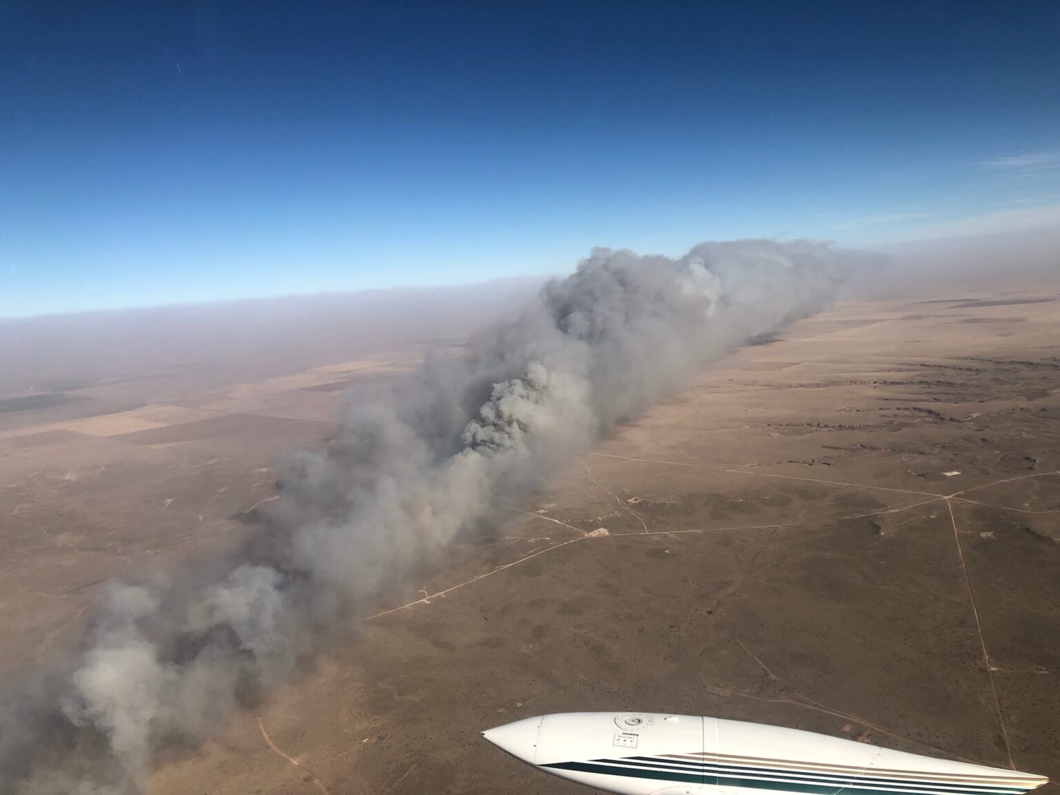
The Kansas Forest Service said Thursday that 11 large fires burned nearly 400,000 acres this week in the state which is entering its dry season while the extreme western part is impacted by drought. The agency reported that the largest fire, dubbed for now the “Four Counties Fire” which is in portions of four counties between Codell and Russell, burned approximately 365,000 acres. The map below shows the fire at about 270,000 acres.
Map of wildfires in Kansas, Dec. 16, 2021. Kansas Forest Service.
Some of the fires are still burning, but not with the speed and intensity seen on Wednesday. The weather forecast for Russell, KS Friday calls for north-northwest winds 8 to 14 mph with gusts to 23 mph, with relative humidity in the mid 30s. Friday night and until Saturday afternoon the winds will be 14 to 18 mph out of the north-northwest with gusts up to 26 mph. Saturday afternoon the humidity will drop into the mid 20s. These conditions will make it difficult for firefighters to put the fires to bed.
Kansas Gov. Laura Kelly issued a declaration of a State of Disaster Emergency on Thursday, Dec. 9 due to elevated dangers of wildland fires.
“Much of Kansas is recovering from yesterday’s storms and wildland fires,” said Mark Neely, State Fire Management Officer, Kansas Forest Service on Dec. 16. “The Kansas Forest Service is working with state and local partners to get fires under control and mopped up so that we can return to normal conditions.”
In a fire outbreak of this size, it can be difficult to keep track of numerous simultaneous incidents, and that is the case this week.
“In Kansas, local officials retain full control of all emergencies, so State agencies receive information as local authorities choose to provide it,” the Kansas Forest Service reported Friday. “It is believed that several of the fires are fully or mostly contained, several will require several more days of work, but details from local officials are still very slow to come in. Additionally, tornadoes, severe winds, dust storms, etc., created havoc nearly statewide.”
Kansas Army National Guard Black Hawk helicopter from the 1st Battalion, 108th Aviation Regiment is used to mop up a fire in western Kansas. Image provided by the Kansas Army National Guard Dec. 17, 2021.
400,000 acres burned in Kansas wildfires Wednesday
Updated 4:35 p.m. Dec. 16, 2021 CST
The red dots represent heat detected by satellites on wildfires near Russell, Kansas, as late as 3:06 a.m. CST Dec. 16, 2021. Clouds and dust at times blocked the view from the satellites and/or the light vegetation burned and cooled between satellite overflights. Therefore, the burned area is likely much larger than shown by the red dots.
A large wildfire in Russell and Ellis Counties in Kansas has burned approximately 96,000 acres and destroyed at least 10 homes, according to the Russell County Sheriff. Satellites were still detecting heat on the fire at 3:06 a.m. CST Thursday. The fire is north of Interstate 70, and is northwest, north, and northeast of Russell, about 7 miles from the city. (UPDATE at 1 a.m. CST Dec. 17: The Kansas Forest Service said the “Four County Fire” has burned 365,850 acres.)
The fire was pushed by very strong winds on Wednesday. A weather station at the Russell Airport recorded wind gusts of 100 mph, which is 26 mph higher than the minimum speed for a Category 1 hurricane.
Many other fires were occurring at the same time in Western Kansas and the panhandles of Oklahoma and Texas (see below).
The Kansas Forest Service assessed the situation Thursday morning:
Wednesday pretty much stripped western Kansas of fire resources, between multiple major fires in critical fire weather, and many traffic crashes. Initial assessment indicates that 11 fires burned a cumulative acreage of nearly 400,000 acres. Further damage details are being assessed by local agencies at this time. Multiple resources will committed, likely for several days.
Dust picked up by the winds created visibility problems, requiring some highways to be closed Wednesday.
Satellite photo, fires in Oklahoma, and Texas, Dec. 15, 2021. The red areas indicate fires.
Eric Metzger, a meteorologist at the National Weather Service in Wichita, told the New York Times that before Wednesday, Kansas had not had any rain for over a month. The state has seen fires in December, when the weather gets dry, he added, but this one felt different.
“I’ve lived out here for more than 20 years,” he added. “This is historic for us.”
Satellite photo, fires in Kansas, Oklahoma, and Texas, 3:51 p.m. CST Dec. 15, 2021. The red dots represent heat detected on fires by satellites.
Update on two fires in the Texas panhandle mentioned earlier, with information from the Texas Forest Service Thursday afternoon: The North 207 Fire between Pampa and Borger is listed at 23,810 acres. The Parker Creek Fire southwest of Dumas is estimated at 11,066 acres.
Thursday morning the Oklahoma Forest Service said the Cobb Fire in the panhandle had burned about 10,000 acres.
Originally published at 8:57 p.m. Dec. 15, 2021 CST
Map of fires in the panhandles of TX and OK. December 15, 2021.
Very strong winds in Kansas and the panhandles of Texas and Oklahoma caused wildfires to spread very rapidly Wednesday. Blowing dust also caused severe visibility problems, and prompted the street lights to come on at noon in at least one area.
Oklahoma
Due to the Cobb Fire in the Oklahoma panhandle the Guymon Police Department in a 2 p.m. Facebook post on Wednesday encouraged the residents on the northwest side of town to evacuate. Heat data from satellites at 1:55 p.m. CST indicated it had burned approximately 5,000 acres northwest of Guymon. The Oklahoma Forest Service said at 7 p.m. it had grown to about 10,000 acres. The eastward progression toward Guymon had been stopped, they said, and one structure was destroyed. Wind gusts up to 79 mph were recorded in the area.
Cobb Fire. Oklahoma Forest Service photo. December 15, 2021.
Texas
Fires in the Texas panhandle were spreading to the east-northeast on Wednesday, also pushed by very strong winds gusting over 80 mph.
The North 207 Fire in Carson County has burned an estimated 15,000 acres about 5 miles southeast of Borger. The Texas Forest Service said it has crossed Highway 152.
North 207 Fire. Texas Forest Service photo. December 15, 2021.
The Parker Creek Fire started in Oldam County and spread into Hartley County southeast of Channing, about 14 miles south of Dumas. The TFS said at 6:08 p.m. it had burned 3,500 acres but satellite heat data indicates it could be larger.
Parker Creek Fire, December 15, 2021. Texas Forest Service photo.
Kansas
There are also numerous fires in western Kansas, also pushed by strong winds out of the west measured in at least one location at 100 mph. The New York Times reported that two fires merged in Russell and Ellsworth Counties in the central part of the state to form a massive blaze about 40 miles long, according to Eric Metzger, a meteorologist with the National Weather Service.
Dozens of firefighters had a very close call on the Route Fire
Fire crews on the Route Fire, 4:40 p.m. Sept. 11, 2021, five minutes before they were nearly entrapped. Photo by one of the firefighters.
Many of the firefighters on the Route Fire who escaped from what was close to becoming a mass casualty incident on September 11, 2021 no doubt had stress levels that were very high as it was happening, and possibly for days, weeks, or months later.
As we covered in an article on December 11, dozens of firefighters on the fire north of Los Angeles suddenly found themselves on a road with fire on all sides of them. Even though it occurred three months ago the story had not been publicly told, until yesterday. As flames closed in on them, a Captain on a US Forest Service engine took charge and organized an effort for 13 firefighters on foot with no access to their regular transportation, to take refuge in two USFS Type 3 engines, each already carrying their normal complement of 5 firefighters. Almost unbelievably, 7 crammed into one engine and 6 got in another. There were a total of 23 bodies in the two engines. Then with flames on both sides of the road, they drove through smoke to safety. Two firefighters were treated in a hospital burn unit and released.
It could have been much worse. One person thought he was going to die.
“The more experienced firefighters were more shaken up than the new guys,” a firefighter told Wildfire Today. “Firefighters on the outside looking in were pretty shaken up, but as best as I can tell I think we are all doing good.”
One person said that as they were becoming entrapped and during the escape from the nearby flames he realized later that he does not have a complete memory of the event, “My memory blacked out from time to time…It’s psychology I don’t fully understand.”
Today I found a reference by Mike Degrosky to an article in the Harvard Business Review written by Diane Musho Hamilton that might shed some light on the topic. Interestingly, at the top of the article is an old photo of a P3 air tanker dropping retardant, even though the word “fire” is not mentioned anywhere in the piece. It starts with describing the two amygdala in the brain which were characterized by Dr. Bessel Van Der Kolk, in his book The Body Keeps the Score, as the brain’s “smoke detector.” (Which may be the genesis for the photo of the air tanker.) The amygdala’s job is to detect fear and help the body prepare for an emergency response.
Here is an excerpt:
“…When we perceive a threat, the amygdala sounds an alarm, releasing a cascade of chemicals in the body. Stress hormones like adrenaline and cortisol flood our system, immediately preparing us for fight or flight. When this deeply instinctive function takes over, we call it what Daniel Goleman coined in Emotional Intelligence as “amygdala hijack.” In common psychological parlance we say, “We’ve been triggered.” We notice immediate changes like an increased heart rate or sweaty palms. Our breathing becomes more shallow and rapid as we take in more oxygen, preparing to bolt if we have to.
“The flood of stress hormones create other sensations like a quivering in our solar plexus, limbs, or our voice. We may notice heat flush our face, our throat constrict, or the back of our neck tighten and jaw set. We are in the grip of a highly efficient, but prehistoric set of physiological responses. These sensations are not exactly pleasant — they’re not meant for relaxation. They’re designed to move us to action.
“The active amygdala also immediately shuts down the neural pathway to our prefrontal cortex so we can become disoriented in a heated conversation. Complex decision-making disappears, as does our access to multiple perspectives. As our attention narrows, we find ourselves trapped in the one perspective that makes us feel the most safe: “I’m right and you’re wrong,” even though we ordinarily see more perspectives.
“And if that wasn’t enough, our memory becomes untrustworthy. Have you ever been in a fight with your partner or friend, and you literally can’t remember a positive thing about them? It’s as though the brain drops the memory function altogether in an effort to survive the threat. When our memory is compromised like this, we can’t recall something from the past that might help us calm down. In fact, we can’t remember much of anything. Instead, we’re simply filled with the flashing red light of the amygdala indicating “Danger, react. Danger, protect. Danger, attack.”
“In the throes of amygdala hijack, we can’t choose how we want to react because the old protective mechanism in the nervous system does it for us — even before we glimpse that there could be a choice. It is ridiculous.”
The first large fire I was on, with El Cariso Hotshots, we had a near miss in Washington state, and had to escape uphill. It was a long, steep, hike out of a canyon with spot fires igniting around us. At the time I was not too concerned, in part because our Superintendent, Ron Campbell, seemed calm, as did the more experienced crew members. I was a sawyer and when another firefighter asked if I needed relief carrying the saw, I was too proud to give it up, and kept it. If I had known the true gravity of our situation I probably would have accepted his offer. As a rookie, I did not appreciate at the time how dangerous the incident was.
Five years later our Laguna Hotshot crew was directed to walk downhill on a partially completed fireline and extend it further. Two other crews were ahead of us. We only got a fairly short distance down the line when all of us were ordered out. We hiked back up to safety with no problem and later the fire ran uphill. After five years on a hotshot crew I didn’t really think too much about it, since to me it did not fall into the near miss category. It can be fairly routine to pull back when it becomes obvious nothing worthwhile can be accomplished or that it can become unsafe. However several days later after we had returned from the fire, one of the rookies quit, citing the event as the reason.
It can be impossible to predict how rookies or experienced firefighters will react to a terrifying narrow escape. It might be life-altering in a negative way, or something that is dealt with, and put away in the “slide file” of experiences to help make better, more informed decisions down the road.
I hope the firefighters on the Route Fire who were nearly entrapped, and those who witnessed it through smoke from a distance, are able to receive counseling if needed and can process what happened September 11, 2021. It’s the kind of traumatic event that can stick with a person and everyone is impacted differently.
As Sgt. Phil Esterhaus used to tell his Hill Street Blues cops as they left the briefing to begin their shift, “Hey. Let’s be careful out there.”
In a very close call, they all escaped, but two were treated in a hospital burn unit
Route Fire, Sept. 11, 2021
On September 11, 2021 dozens of firefighters working on the Route Fire north of Los Angeles suddenly found themselves with fire on all sides of them. Even though it occurred three months ago the story has not been publicly told, until today.
Helicopter-based flight crews, hand crews, and several Los Angeles County and US Forest Service engine crews were working on the fire seven miles north of Castaic between Interstate 5 and old highway 99, also known as Golden State Highway. The crews and engines positioned ahead of the fire had been on scene for about 30 minutes looking for the right time and place to engage the fire, which had previously moved west across the 99. Eventually it turned hard north, then east back to the highway behind the crews, with spot fires occurring out ahead. As it neared the highway, flames seen in the videos appeared to be 20 to 40 feet high when they bent over the road as the heavy brush was rapidly consumed.
Route Fire, Sept. 11, 2021. Looking south.
The fire spread north was undetected by the firefighters on the highway due to topography, and the lookouts became inadequate as the fire grew. Air resources observed the pinching action of the fire, along with fire crews on Interstate 5. As they tried to communicate it was time to leave, a bottleneck occurred. South and north of the crews the highway was four lanes wide, but at that point it was only two lanes wide.
Route Fire map. USFS.
The two flight crews of approximately 11 persons each had been transported by helicopters, but were obviously on foot after being dropped off. The crew that was the furthest out from the worst of the entrapment was able to load their personnel into LA County engines and escape.
Closer to the roaring flames the other flight crew, on foot, was in imminent danger. Two US Forest Service engines, each staffed with five firefighters, were able to find a way to cram the 11-person flight crew plus two others into the two FS engines, coordinated by Engine Boss Tom Guzman. Seven members of the flight crew climbed into one engine, and the other took four plus an additional two firefighters who were on foot nearby. They had trouble getting the doors to close. There were 23 bodies in the two engines, with seating designed for five each. The last person in one of the engines came in through the driver’s door and was lying across several people on the front seat as the driver found a way to still operate the truck as he navigated through the smoke, avoiding parked or slow-moving fire apparatus on the two-lane highway as his air horn blasted.
Route Fire, Sept. 11, 2021
Many of the flight crewmembers were rookies and kept their tools as they climbed over bodies into the suddenly very cramped cabs. One of them was on his first fire.
A firefighter from the US Forest Service suffered second degree burns to his ears, neck, nose, cheeks, and arm. Another from LA County received a second degree burn to his neck. They were both treated by paramedics on scene, transported to a hospital emergency room, and later to a burn unit, and then released.
Route Fire, Sept. 11, 2021
“The more experienced firefighters were more shaken up than the new guys,” one firefighter told Wildfire Today. “Firefighters on the outside looking in were pretty shaken up, but as best as I can tell I think we are all doing good. I’ve learned that things like this are more common than people realize, but until recent times they haven’t been captured on video, so they were never made known.”
Route Fire, Sept. 11, 2021
Multiple firefighters captured it on videos. Wildfire Today obtained a three-minute version that the US Forest Service distributed internally, below, which tells part of the story of the near miss.
By the next morning the spread of the Route Fire had been stopped at 454 acres thanks to the work of firefighters on the ground and numerous aircraft.
For his actions on the Route Fire, Tom Guzman, who was serving as an Engine Boss, received a “USDA Forest Service Pacific Southwest Region Emergency Response Award”. More details about the award are at the end of the video.
After the interviews that were conducted shortly after the incident the firefighters were told that a “Rapid Lesson Sharing” document would be produced. As of December 11, 2021 it has not appeared.
The still images seen here are from the videos shot by the firefighters.
L to R: Brandon Cordell Bennett Jr., Jevin James Mclean, Galvinn Coates Munson. Photo: Cascade County Detention Center.
Three teens have been charged with arson for starting two fires last week, one of which destroyed 13 homes, 16 outbuildings, and numerous vehicles in Gibson Flats just south of Great Falls, Montana.
Those charged were Brandon Cordell Bennett, Jr. 18; Jevin James Mclean, 19; and Galvinn Coates Munson, 19; all of Great Falls.
Munson was also charged with 15 counts of criminal endangerment. Bennett received an additional charge of tampering with evidence for reportedly “wiping” his phone.
The two fires, which burned about 120 acres, started at around 2:40 a.m. December 1 pushed by strong winds gusting at more than 50 mph.
“One of the defendants disclosed that all three of them were driving around the area the night this occurred smoking marijuana and shooting fireworks at each other inside the vehicle,” Cascade County Sheriff Jesse Slaughter said in a news conference.
The Sheriff said the fact that no one was killed was a “complete miracle.”