Wildfire activity increases in Manitoba and Ontario

The Red 023 Fire near Sandy Lake in Ontario made a 20 kilometer run Monday afternoon and night

wildfires Manitoba Ontario June 2 2019
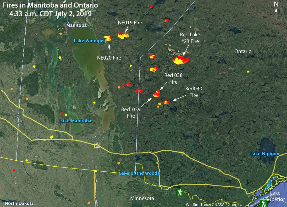
Map showing the locations of wildfires in Eastern Manitoba and northwest Ontario at 4:33 a.m. CDT July 2, 2019.

Wildfire activity in Canada has spread from British Columbia and Alberta, east to the provinces of Manitoba and Ontario. In the last several days about a dozen fires have grown much larger in Eastern Manitoba and Northwestern Ontario. Winds out of the west Monday afternoon and night forced some of blazes to grow substantially to the east and northeast.

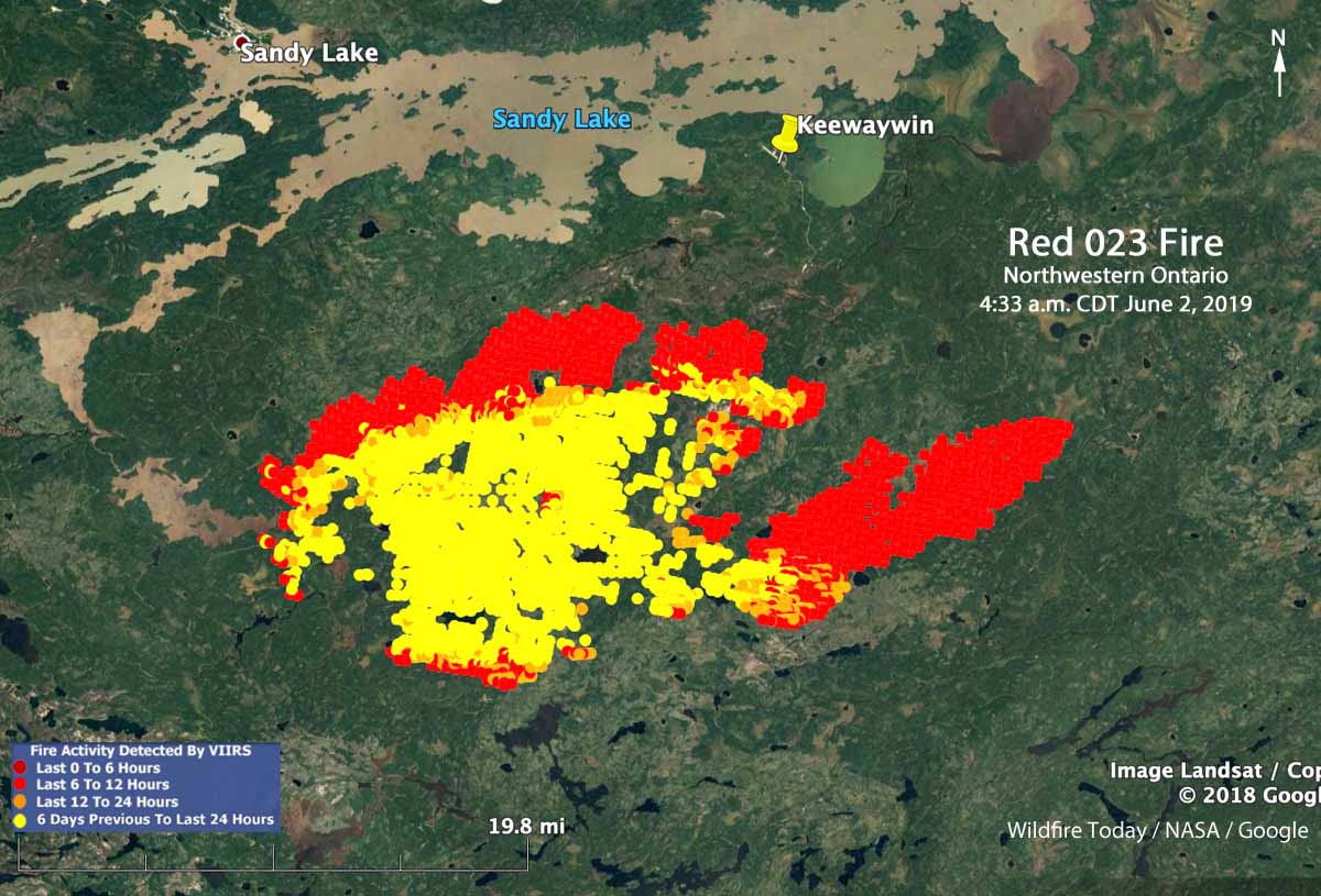
The largest in the area is in Northwestern Ontario, the Red 023 Fire that started June 15. As illustrated in the map below, between 2:42 p.m. July 1 and 4:33 a.m. CDT July 2 the fire ran east for about 20 kilometers (13 miles). Early Tuesday morning it was 4 miles south of Sandy Lake and six miles southwest of the community of Keewaywin.

The Ontario Ministry of Natural Resources and Forestry’s latest estimate of the size of the Red 023 Fire was 37,390 Ha (92,392 acres). After the major run, our very, very unofficial estimate using satellite data estimates that it has grown to at least 54,000 Ha (130,000 acres).
Map Red 023 fire Keewaywin Ontario Sandy Lake
Map showing heat on the Red 023 Fire detected by a satellite as late as 4:33 a.m. CDT July 2, 2019. The red areas burned between 2:42 p.m. July 1 and 4:33 a.m. CDT July2.

There are three large fires in Ontario northwest of Trout Lake that all started June 30. (See the map at the top of the article) The sizes were reported by the Ontario Ministry of Natural Resources and Forestry on July 1, 2019:

  • Red 038 Fire, 1,100 Ha (2,700 a)
  • Red 039 Fire, 10,000 Ha (24,700 a)
  • Red 040 Fire, 2,832 Ha (7,100 a)

Two of the larger fires in Manitoba are the NE 020 Fire and the NE 019 Fire, east of Lake Winnipeg and southeast of Playgreen Lake, both reported in mid-June. Their reported sizes are 11,000 Ha (27,000 acres) and 9,000 Ha  (22,000 acres), respectively.

The weather forecast for the Pikangikum, Ontario area through Saturday calls for temperatures in the mid to high 70s F, partly cloudy or sunny, winds generally out of the west during the day at 5 to 12 mph, and very little chance of rain.

The map below shows the forecast for the distribution of wildfire smoke from the fires in Alaska, Manitoba, and Ontario at 7 p.m. CDT July 3, 2019.

Smoke Forecast wildfires Canada
Forecast for the distribution of wildfire smoke at 7 p.m. CDT July 3, 2019, produced July 2 by the Canadian government. The forecast only includes the area within the black border.

July could bring elevated wildfire potential to parts of the west coast, Alaska, Arizona, and the Southeast

Moderate to severe drought conditions exist in western Oregon and Washington

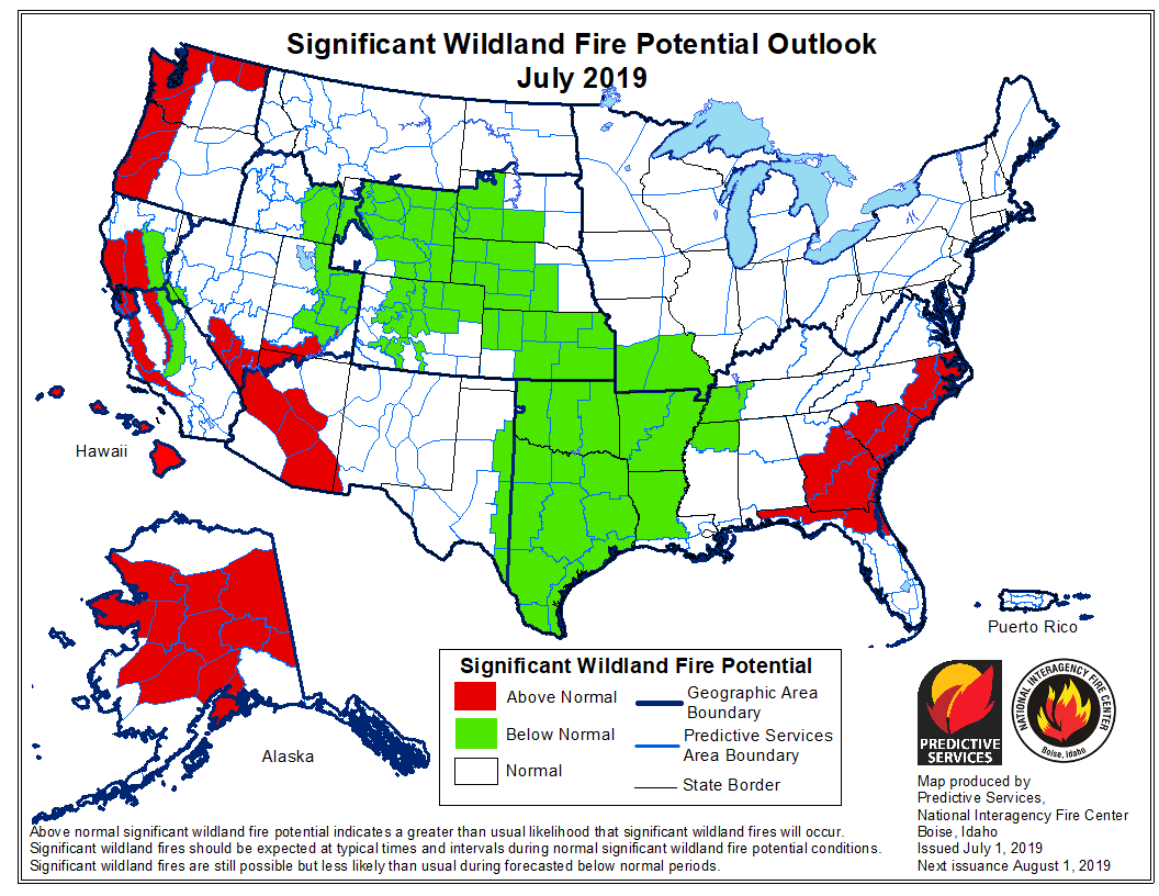
wildfire outlook 2019 July

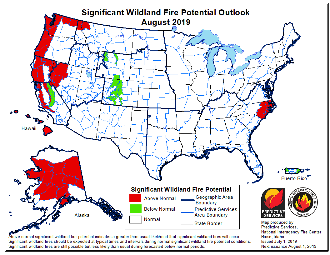
On July 1 the Predictive Services section at the National Interagency Fire Center issued their Wildland Fire Potential Outlook for July through October. The data represents the cumulative forecasts of the ten Geographic Area Predictive Services Units and the National Predictive Services Unit.

If NIFC’s analysis is correct, areas in California, Washington, Oregon, Arizona, Alaska, and California will have elevated potential for wildfires at times during the four month period. Forecasters predict portions of Florida, Georgia, and the Carolinas will have enhanced potential in July.

The areas affected by the multi-year drought in the West have greatly decreased to the point where there are no locations with extreme or exceptional drought. No areas in California are listed as being in drought status, which is a major change from five or six months ago.

Below:

  • An excerpt from the NIFC narrative report for the next several months;
  • More of NIFC’s monthly graphical outlooks;
  • NOAA’s three-month temperature and precipitation forecasts;
  • Drought Monitor;
  • Vegetation greenness map.

From NIFC:

“Moderate to severe drought conditions exist across Washington and Oregon, especially across western portions of both states. Soil moisture levels are drier than average and drought stress exists. Another area of concern is southern Arizona. While fuel conditions across most of the Southwest exhibit above average fuel moisture and greenness, the southern third of the state is the anomaly. Areas along and north of the Mexican Border remain persistently dry. Periodic wind events have led to critical periods with above normal activity observed. This area will remain a concern until the monsoon arrives in July.

“Alaska experienced a slow entry into its season. By mid-June fire activity increased significantly as fuels continued dried. Numerous lightning events produced a significant number of fire starts. The consistent warm and dry pattern observed at month’s end suggested that the state will continue to be active well into July before the season begins to wind down with the arrival of late summer rains in August.

“In California, robust crop of grasses has grown. The fuel beds have become more continuous than what is typically seen. When the hot, dry, and windy patterns develop during the middle to late summer months, the large fire potential in these areas will elevate. In the higher elevations, the abundant moisture received translated into historic snowfall. This and slow melting rates will translate into a delayed entry into the fire season. To the east, concerns across the Great Basin are rising due to heavy fuel loading and an expected long-duration heat event in early July that should propel the region into fire season.

“With fine fuels fully cured across the West and high elevation larger fuels becoming adequately dry in August, fire season 2019 will peak in August across much of the West. Exceptions to this will be the Southwest where an ongoing monsoon reduced fire activity and the central Rockies, which may not have enough time to fully dry and cure before monsoonal moisture, begins to affect the region.

“A gradual decrease in fire activity is expected to begin by mid-September as the seasonal transition begins and as shortening days translate to shorter burn periods and better overall humidity recoveries overnight. California will begin to reenter fire season in October as East and North wind events begin to occur.”


wildfire outlook 2019 August
Continue reading “July could bring elevated wildfire potential to parts of the west coast, Alaska, Arizona, and the Southeast”

Documentary on the Honda Canyon Fire fatalities

Firestorm Documentary Honda Canyon FireA documentary is being produced for a multi-fatality wildfire that occurred in the 1970s.

On December 20, 1977, three people were entrapped and killed on the Honda Canyon fire on Vandenberg Air Force Base in southern California, including the Base Commander Colonel Joseph Turner, Fire Chief Billy Bell, and Assistant Fire Chief Eugene Cooper. Heavy Equipment Operator Clarence McCauley suffered severe burns and later died from the complications.  A book about the fire, “Beyond Tranquillon Ridge”, was written by Joseph N. Valencia.

Mr. Valencia, one of the first firefighters on the fire, is serving as a technical consultant on the documentary, titled “Firestorm”, which is adapted from the book.

Here is how Mr. Valencia described the fire to us in an email:

A combination of hurricane-force winds and the snapping of an electrical pole starts the Honda Canyon Fire on Vandenberg Air Force Base, California, early in the morning of December 20, 1977. Over a thousand people consisting of professional firemen and military personnel fight the fire. Outlier winds would increase to over a hundred miles per hour, making the firefight almost impossible. Four fatalities and sixty-five injuries resulted. Ten-thousand acres burn, resulting in significant damage to the military installation infrastructure. Ironically and fortuitously, the fire will be out, a little more than 30 hours later, due to a rain storm-front coming in.

Others working on the film include producer Dennis R. Ford, and
Christopher Hite, Director of Photography and Cinematographer.

Many interviews have been filmed with people that were on the incident. One of the many reasons for making the documentary is to collect information about the catastrophe that occurred 42 years ago while the witnesses and participants are still available. You can view some of the interviews at the film’s Facebook page.

The trailer for the film is on Vimeo.

They are hoping to complete production by early 2020.

Mr. Valencia also wrote Area Ignition, the story of the 1979 Spanish Ranch Fire near Santa Maria, California.

Granite Mountain Hotshots — Six years ago today

Granite Mountain Hotshots

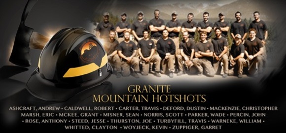
It was six years ago today, June 30, 2013, that 19 members of the Granite Mountain Hotshots died on the Yarnell Hill Fire south of Prescott, Arizona. May they rest in peace. Our hearts go out to their families and friends.

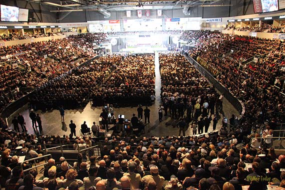
memorial service Granite Mountain Hotshots
The memorial service for the Granite Mountain Hotshots, July 9, 2013. Photo by Bill Gabbert.

Lightning blankets Montana and the Northwest

lightning map montana washington idaho oregon
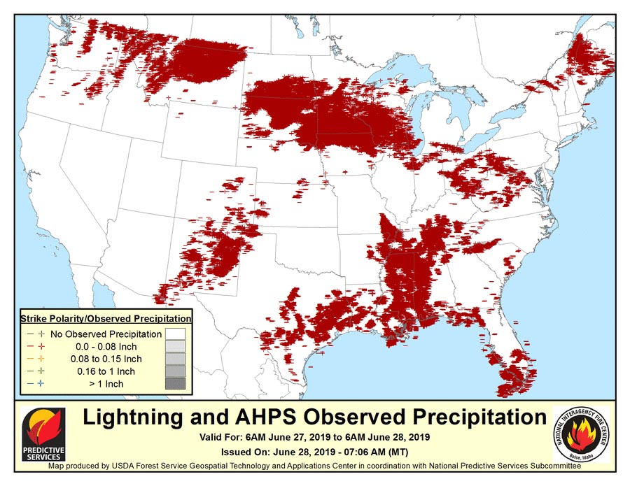
Lightning detected between 6 a.m. June 27 and 6 a.m. June 28 (MT).

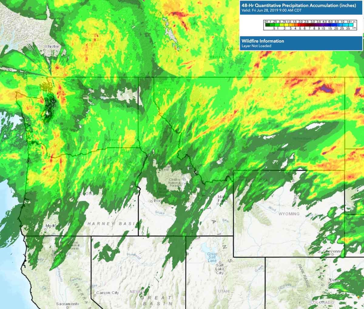
Thousands of lighting strikes hit Montana, Idaho, Washington, and Oregon Thursday and Thursday night. Much of the area also received at least a little precipitation over the last 48 hours, which could reduce, but not eliminate, the threat of new wildfires.

lightning precipitation rain
Precipitation that occurred during the 48 hours ending at 8 a.m. MDT June 28, 2019.

Demob begins on the Woodbury Fire

Woodbury Fire Phoenix Roosevelt
The Woodbury Fire visited the Superstition Wilderness, June 22, 2019. InciWeb.

The spread of the Woodbury Fire east of the Phoenix suburbs has slowed considerably, allowing fire managers to begin “right-sizing” the fire, according to information released by the Incident Management Team (IMT). Some firefighting resources are being demobilized.

The Southwest Area Type 1 IMT 2 is starting an initial transition of duties to the Arizona Central West Zone Type 3 IMT. The Type 3 team will assume command of the fire at 6:00 a.m. tomorrow, June 28th.

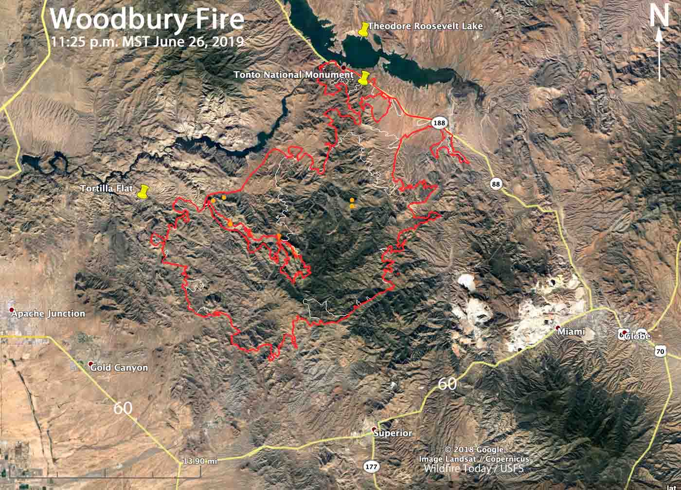
Below is a map of the Woodbury Fire.

Map of the Woodbury Fire P
Map of the Woodbury Fire. The red line was the perimeter at 11:25 p.m. MDT June 26. The white line was the perimeter June 22, 2019. Click to enlarge.

The work remaining on the fire includes patrolling, securing, and monitoring firelines. Fish Creek, Pinyon Mountain and Two Bar Ridge have interior pockets of vegetation burning within the fire perimeter. These areas pose no threats to the fireline, however southwest winds will push smoke towards the Roosevelt area on Thursday.

An Unmanned Aerial System, or drone, was used Tuesday to fly over the eastern border of the fire to scout for hotspots. The aircraft detected heat within the fire perimeter and helicopters then dropped water and firefighters constructed line on the ground. The IMT used the drone again on Wednesday.

Woodbury Fire Phoenix Roosevelt
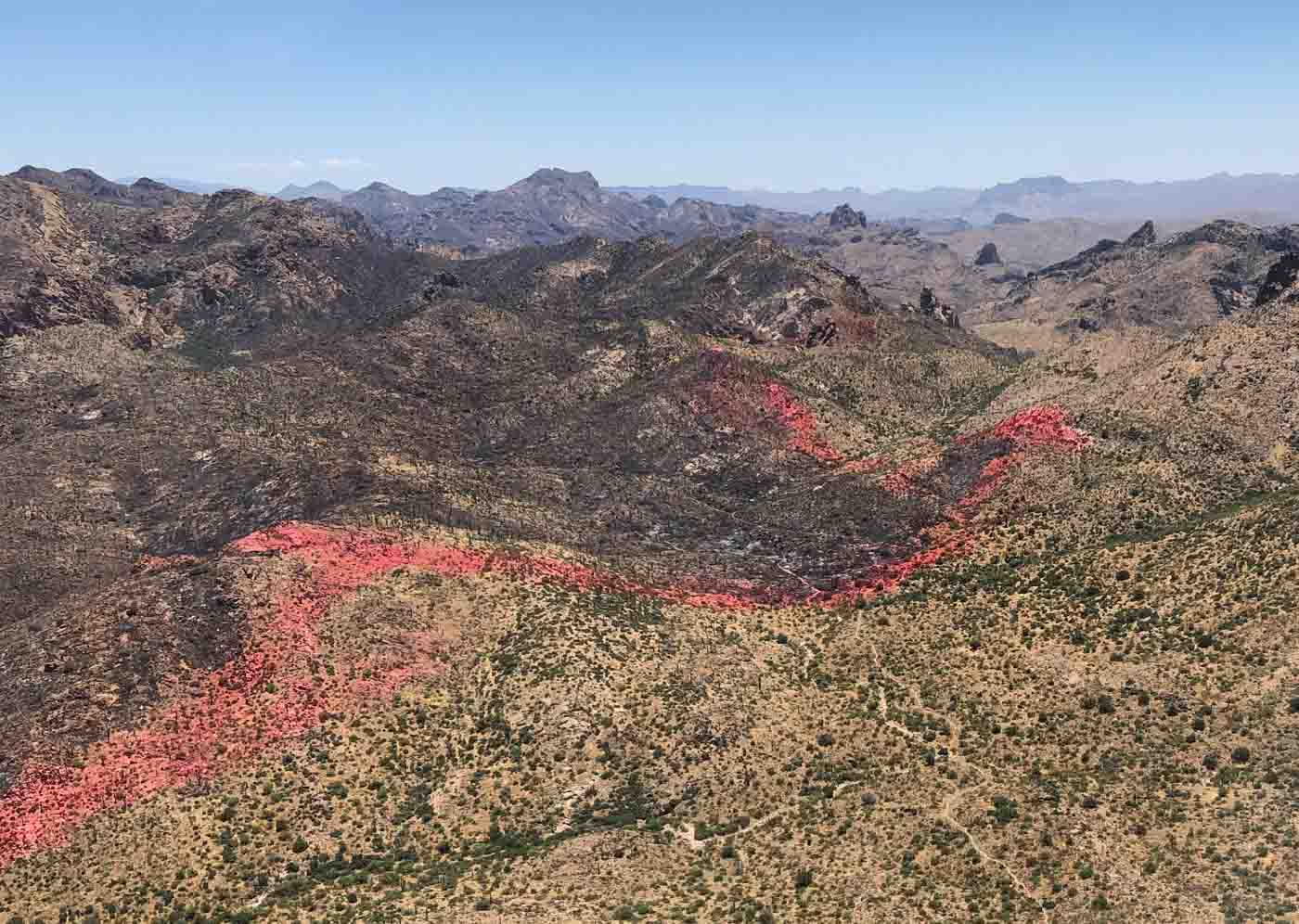
A line of fire retardant dropped by aircraft helped hold a section of the perimeter of the Woodbury Fire near Coffee Flat. Date unknown. InciWeb.