Social media can help identify evacuation patterns

Data can help determine when people relocate in or out of an evacuation area

social media evacuation pattern Ranch Fire wildfire
August 5, 2018

In July 2018, a spark near the Mendocino National Forest ignited California’s largest wildfire on record. As the Ranch Fire spread rapidly, officials declared mandatory evacuations in several areas and counties. But where did people go, when did they leave, and when did they return? Researchers have turned to a new data source to observe population movements during a crisis: social media.

“We wanted to analyze evacuation patterns and factors that can influence the speed of evacuations during a crisis,” said Shenyue Jia, a remote sensing specialist at Chapman University.

Analyzing evacuation and recovery patterns could help researchers understand how humans behave in the face of a disaster, which could inform emergency response efforts. Jia said nobody was able to provide population movements during a disaster, especially at a high temporal and spatial resolution—until Facebook.

Almost 2.5 billion people per month actively use Facebook. When a disaster strikes, many of those users log on during an evacuation. Facebook’s disasters map initiative uses aggregated, anonymized Facebook data in disaster areas to estimate population densities, movements between neighborhoods, and where people mark themselves as “safe” during a crisis. The company also works with mobile phone carriers to observe the number of connections to surrounding cell phone towers.
social media evacuation pattern Ranch Fire wildfire
August 8, 2018

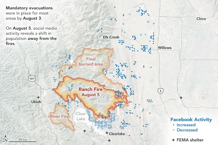
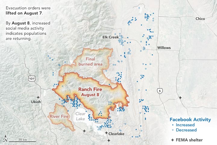
The images on this page show the population data during the Mendocino Complex Fire in Northern California for 10,000 people, as provided by the Facebook disaster map dataset. The first map above shows the area on August 5, 2018, two days after mandatory evacuations were in place. The second map below shows the area on August 8, one day after the evacuation orders were lifted.

During the Mendocino Complex fire, most people fled the fire perimeter when an evacuation was in place, which was not surprising. But what surprised Jia was where people were headed—or not headed.

“Originally, I thought this data could be nice to track which places people decide to go, but the information didn’t show any significant pattern for this fire,” said Jia, whose research was funded by NASA. “I was expecting a very simple trend, but evacuations are more complicated to understand.”

Jia thinks that perhaps people had more shelter options to flee to (FEMA shelters, neighboring towns, etc.), so the evacuation patterns were dispersed.

However, when the evacuations were lifted, the data showed a much clearer trend of where people were headed: most were returning back to their homes and hometowns. Jia said that how the population bounces back post-disaster is an important indicator of whether the evacuated areas may be safe for residing. In the Mendocino Complex fire, most areas saw people returning.

But that’s not always the case. Jia also analyzed population data from Facebook for the Camp Fire that occurred in November 2018. The data showed a large portion of the evacuated area did not see a sustainable population return since many of those areas were destroyed.

“This research demonstrates that social-network data can be a valuable tool to monitor human behaviors in response to disasters, such as wildfires in areas that have been exacerbated by urbanization,” said Son Nghiem, remote sensing expert at NASA’s Jet Propulsion Laboratory, who oversaw this research.

According to Nghiem, this frequently updated social media data can add another dimension to satellite remote sensing data from NASA and other international agencies used to monitor land cover and land use change.

“With remote sensing data, we don’t know the immediate socioeconomic and demographic impacts,” said Nghiem. “This innovative use of demographic data opens up new possibilities to advance research on how humans respond to abrupt physical changes in disaster situations.”

This article first appeared on the NASA website. NASA Earth Observatory images by Joshua Stevens, using data courtesy of Shenyue Jia/Chapman University. Story by Kasha Patel.

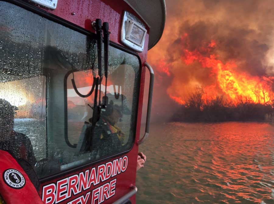
Firefighters battle the Beach Fire along Colorado River

The blaze is in Lake Havasu City, Arizona

Beach Fire Lake Havasu City
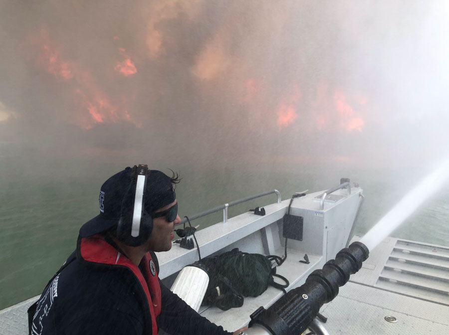
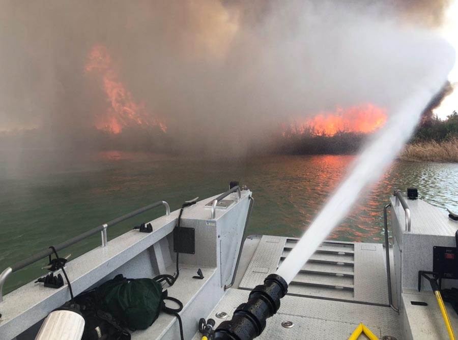
The Beach Fire along the Colorado River near Lake Havasu City, Arizona. Photo by San Bernardino County FD.

(UPDATED at 7:12 a.m. PDT April 1, 2019)

The Bureau of Land Management reported Sunday evening that the fire had burned 80 acres and most of the resources were being released. However, some would remain on scene overnight others will staff it today, Monday.


(Originally published at 4:53 p.m. PDT March 31, 2019)

Firefighters are working on the Beach Fire burning on the banks of the Colorado River at Body Beach in Lake Havasu City, AZ. At about 3:45 p.m. PDT fire officials said the northeast wind had picked up and it was moving the fire, which was 40 acres at that time, south along the shoreline on land managed by the Bureau of Reclamation. County and Bureau of Land Management structures were being threatened.

BLM, San Bernardino County Fire, and other departments were on scene.

These photos were shot from a San Bernardino County FD fire boat.

Beach Fire Lake Havasu City
The Beach Fire along the Colorado River near Lake Havasu City, Arizona. Photo by San Bernardino County FD.
Beach Fire Lake Havasu City
The Beach Fire along the Colorado River near Lake Havasu City, Arizona. Photo by San Bernardino County FD.
Beach Fire Lake Havasu City
The Beach Fire along the Colorado River near Lake Havasu City, Arizona. Photo by San Bernardino County FD.
Beach Fire Lake Havasu City
The Beach Fire along the Colorado River near Lake Havasu City, Arizona. Photo by San Bernardino County FD.

Spring Hill Fire spreads across 10,000 acres in New Jersey

The fire is just north of the Penn State Forest

map Spring Hill Fire pine barrens New Jersey
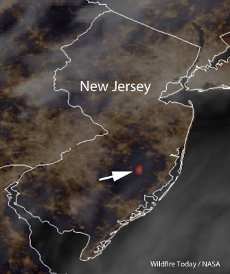
The arrow on the map points to the Spring Hill Fire in New Jersey. Satellite image at 9:07 p.m. EDT March 30, 2019. Wildfire Today / NASA

(Updated at 3:04 p.m. EDT March 31, 2019)

The wildfire burning in New Jersey in the Penn State Forest in Burlington County near the Ocean County border has grown to about 10,000 acres, fire officials said at 2:45 p.m on Sunday. Firefighters have been conducting burnout operations out ahead of the fire to remove the fuel and slow down the blaze.

Route 72 is still closed.


(Updated at 1:25 a.m. EDT, March 31, 2019)

Officials in New Jersey said Sunday morning that the Spring Hill Fire in the Pinelands had grown to about 8,000 acres. Route 72 west of Route 539 in Barnegat remains closed while firefighters are working in the area.


(Updated at 8:53 a.m. EDT March 31, 2019)

A fire that started at 1:45 Saturday afternoon in the New Jersey Pinelands had burned approximately 5,000 acres by 10 p.m. Pushed by strong winds out of the south-southwest at 10 mph gusting up to 25 mph it ran to the north and northeast forcing authorities to close Route 72 west of Barnegat. The fire started in the Penn State Forest in Burlington County near the Ocean County border when the relative humidity was 33 percent.

Satellite imagery showed that the fire was still very active throughout the night into early Sunday morning, especially at 4:22 a.m. EST. Later, clouds moved in and obscured the view.

map Spring Hill Fire pine barrens New Jersey
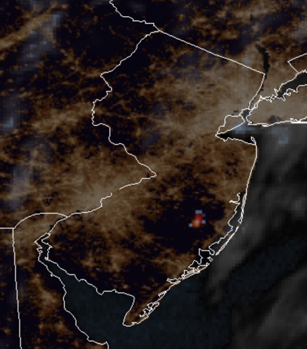
The red and gray dots represent the location of the wildfire in New Jersey as seen from a satellite at 4:22 a.m. EDT March 31, 2019.

It started in an area in which there are few structures.

The weather forecast calls for a 60 to 70 percent chance of showers Saturday night and Sunday.

The video below was shot by the Ocean County Sheriff’s Office on March 30.

Thanks and a tip of the hat go out to Capt. Typos or errors, report them HERE.

Firefighter in Texas killed in helicopter crash

(This article was first published on FireAviation.com)

(UPDATED at 2:16 p.m. MDT March 28, 2019)

The firefighter that died in the Texas helicopter crash on March 27 has been identified by the U.S. Forest Service as Daniel Laird, a Captain on the Tahoe Helitack crew in California. He leaves behind a wife and young daughter.

One source tells us that the other passenger was also a USFS firefighter who was sitting in the front seat when the aircraft went down, but reportedly walked away and was treated and released from a hospital.

Daniel J. Laird firefighter LODD
Daniel J. Laird. Tahoe National Forest photo.

The pilot was also transported to a hospital in stable condition, according to the information reported yesterday by Sergeant Erik Burse with the Texas Department of Public Safety.

Below is a letter from the USFS Regional Forester in California:

“You may have already heard from Secretary Perdue and Chief Christiansen that we lost one of our own, Daniel Laird, yesterday, in a helicopter accident while conducting a prescribed burn with our Region 8 partners on the Sam Houston National Forest in Texas. Daniel was 41 years old and leaves behind his wife Heather and daughter Evain.

“Daniel started as a seasonal firefighter on the Tahoe [National Forest] and worked his way up to Helitack Captain. His passion was in aviation, but he was also known for his ability to lead a strike team of engines or a task force of hand crews and heavy equipment. He was a true leader in every sense. He was dedicated to being an instructor and a believer in the apprentice program, where he helped grow people just like himself. Daniel was originally from Graeagle, CA, and committed his working life to the Forest Service. He was extremely knowledgeable about his craft and loved his job. He had an infectious smile, natural physical talent, and his greatest love of all was his family.

“Our Forest Service family is hurting over this tremendous loss. It is an emotional time and Daniel’s loss can impact even the strongest among us. We grieve with Daniel’s immediate family, friends, and community. Please keep them all in your thoughts and prayers. The Region is providing support to the Tahoe and all who need it as they digest this sad news. I will pass more details on arrangements once they become available.

“Please continue to look out for one another and take care of one another.”

Randy Moore
Regional Forester
USFS R5


(UPDATED at 9 a.m. CDT March 28, 2019)

The deceased firefighter was a U.S. Forest Service employee who, along with the other firefighter and the pilot, were on an aerial ignition mission. Their equipment was dropping plastic spheres that burst into flame after hitting the ground, helping to ignite the prescribed fire. No names have been released.


(Originally published at 7:20 p.m. CDT March 27, 2019)

One firefighter was killed in the crash of a helicopter today while working on a prescribed fire in the Sam Houston National Forest about 30 miles southeast of College Station, Texas south of Highway 149.

Sergeant Erik Burse with the Texas Department of Public Safety said the Eurocopter AS350 went down at about 2 p.m. with three people on board, a pilot and two firefighters. One of the firefighters was deceased on scene. The pilot and a second firefighter were transported to a hospital in stable condition.

map helicopter crash sam houston national forest
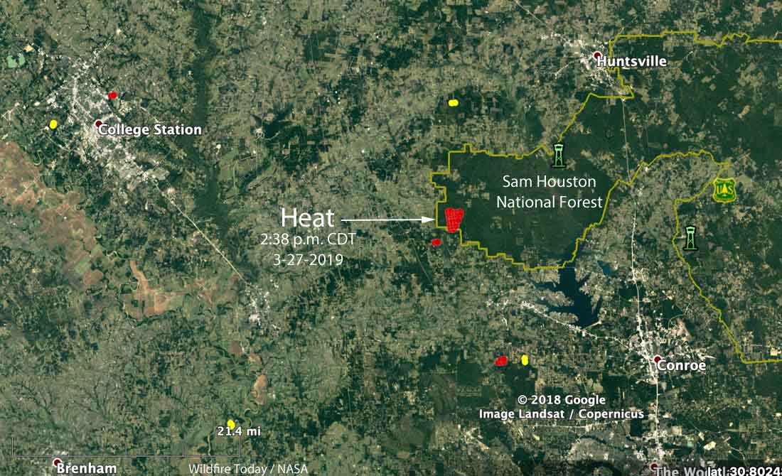
Map showing heat in the Sam Houston National Forest detected by a satellite at 2:38 p.m. CDT March 27, 2019. There is a possibility the heat could have been produced by a prescribed fire.

Our sincere condolences go out to the family, friends, and coworkers of the firefighter, and we hope for a speedy recovery of the injured personnel.

Thanks and a tip of the hat go out to Perry. Typos or errors, report them HERE.

Establishment of firefighter cancer registry is progressing

The next step is to collect input from firefighters and stakeholders on an approach to the Registry including potential enrollment methods

A firefighter works a blaze in Northern California. Photo courtesy CAL FIRE.
A firefighter works a blaze in Northern California during the fires in Wine Country in 2017. Photo courtesy of CAL FIRE.

(UPDATED at 10 a.m. MDT March 28, 2019)

The Request for Information about the new National Firefighter Registry described below was published today. The National Institute for Occupational Safety and Health (NIOSH), an agency within the Centers for Disease Control and Prevention (CDC), is requesting input about three possible enrollment strategies. Specifically, NIOSH is asking for input on how to maximize participation for the Registry. The comment period will close on May 28th, 2019.

The process for leaving a comment is convoluted. They ask you to click on this link and then you have to search for the appropriate issue. I searched for “National Firefighter Registry” which brought up 208 results. When I checked today it was the first one.

When found, you have to click in the search results on “Comment Now”(over on the right)  Maybe THIS will take you directly to the comment form.

Keep in mind that any information (e.g., personal or contact) you provide on the comment form may be publicly disclosed and searchable on the Internet and in a paper docket. But you don’t have to leave your name or email address.


(Originally published at 2:41 p.m. MDT March 27, 2019)

In April, 2017 a bill was introduced in Congress that would establish a registry to track the occurrence of cancer among firefighters. A version of the bill was finally signed into law on July 7, 2018. Now, eight months later it appears that the creation of the registry is some distance from becoming a reality, but we can report some progress.

The legislation called it a Firefighter Cancer Registry, but it appears that the name has changed to National Firefighter Registry — a vague term which does not provide a clue about the purpose.

Kenny Fent is the Team Lead for what will become the National Firefighter Registry Program. Mr. Fent is a Research Industrial Hygienist with the National Institute for Occupational Safety and Health, a division of the Centers for Disease Control and Prevention. He told us that soon the agency will post a Request for Information (RFI) to the Federal Register regarding the Registry. During a 60-day period they will seek input on an approach to the Registry including potential enrollment methods. All stakeholders, including firefighters, will be encouraged to review the document and respond with comments.

NIOSH-CDC logoOnce the Registry design is finalized, CDC/NIOSH will begin enrollment. Where possible, CDC/NIOSH will collect work history and exposure records to explore the relationship between exposures and cancer. They will also link with state cancer registries to confirm diagnoses. Findings will be shared through scientific publications and communications to stakeholders and the public.

Previous studies, including a study completed by the National Institute for Occupational Safety and Health (NIOSH) in 2014, have highlighted firefighters’ increased risk for certain cancers compared to the general population. However, few previous studies have collected data about wildland firefighters, volunteer firefighters, or sufficient numbers of female and minority firefighters in order to draw conclusions regarding their risk of cancer.

In one study that collected data from wildland firefighters in the field, a group of researchers concluded that firefighters’ exposure to smoke can increase the risk of mortality from lung cancer, ischemic heart disease, and cardiovascular disease by 22 to 39 percent. The project only looked at the wildland fire environment, and was not a long term study of firefighters’ health.

The ultimate goal of the Registry is to better understand the link between workplace exposures and cancer among firefighters. The Registry will include all U.S. firefighters, not just those with a cancer diagnosis. The Registry also has the potential to provide a better understanding of cancer risk among subgroups such as women, minorities, and volunteers, and among sub-specialties of the fire service like instructors, wildland firefighters, and arson investigators.

From the Registry information, CDC/NIOSH will estimate an overall rate of cancer for firefighters. They might find certain groups of firefighters are at a higher risk of cancer than others based on level of exposure, geography, gender, or other factors. They may also find that certain protective measures are associated with a reduced risk for cancer, which could provide additional evidence and support for specific control interventions.

The Registry will be completely voluntary, and no one can force a person to join.

All active and retired as well as volunteer, paid-on-call, and career firefighters will be encouraged to join the Registry, regardless of their current health status.

CDC/NIOSH promises that they will always maintain participants’ privacy and will never share personal information with an outside organization including fire departments, unions, or other researchers without permission of the individual.

Wildland fire research funding opportunities

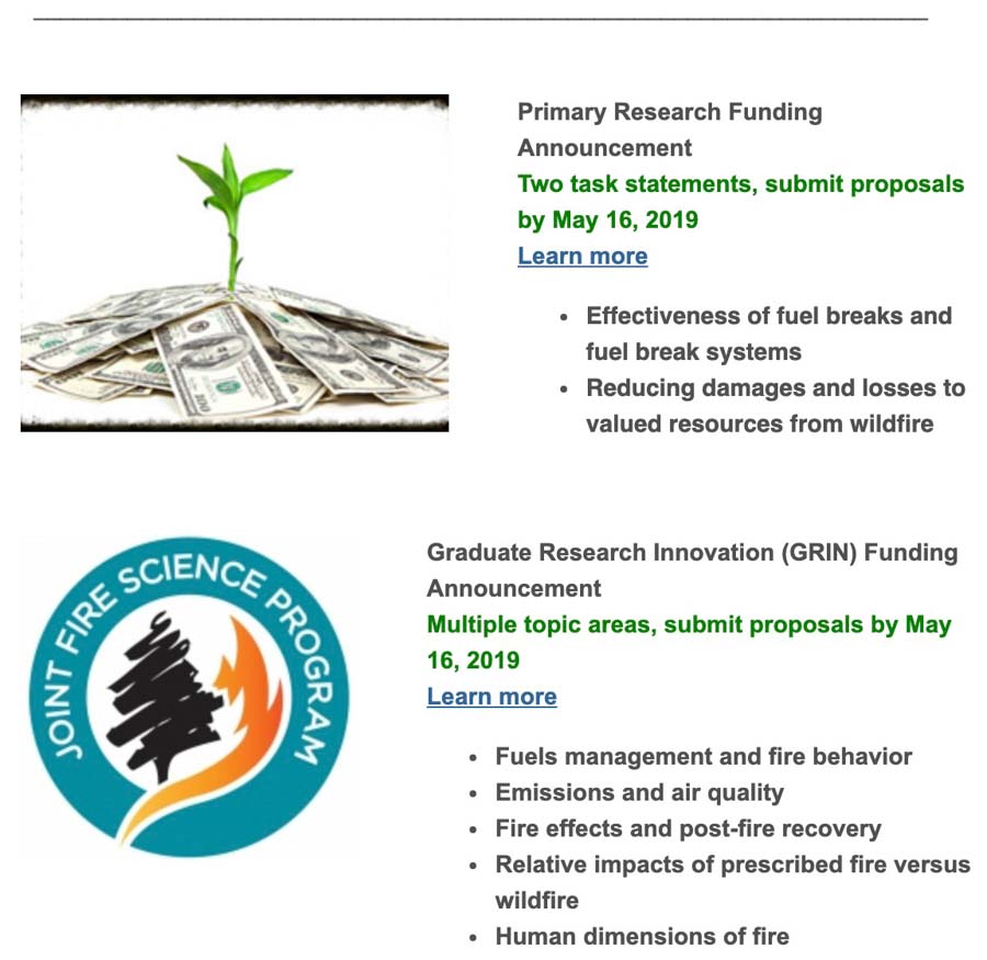
The Great Basin Fire Exchange has accomplished a good deed for the wildland fire research community. They took a painful-to-read announcement about opportunities for research funding from the Joint Fire Science Program and distilled it into a short and uncomplicated notice.

(The links in the image below don’t work, since it’s a screen shot, but they both go to HERE.)

jfsp funding announcement

A researcher considering applying for funding will still need to go to the JFSP site to get the details. Proposals are due by May 16, 2019.

In FY 2017, 16 of the 22 approved projects were various ways of studying vegetation. Back then we wrote:

It would be refreshing to see more funds put toward projects that would enhance the science, safety, and effectiveness of firefighting.

Judging from the descriptions of the current funding opportunities it appears that the JFSP is moving away from awarding 72 percent of the awards to vegetation studies.