Firefighters get new tool for predicting wildfire danger

Hot-Dry-Windy Index

HDW index CF34 Fire wildfire weather Colorado
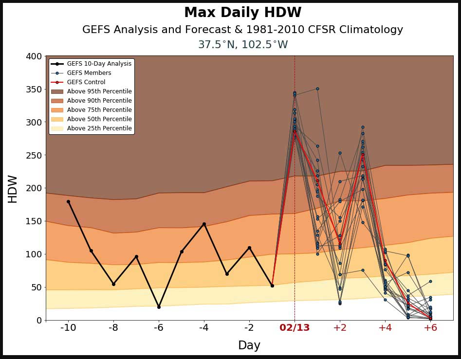
Hot-Dry-Windy Index for the area of the CR34 Fire in southeast Colorado February 13, 2019.

The Hot-Dry-Windy Index (HDW) is a new tool for firefighters to predict weather conditions which can affect the spread of wildfires.

It is described as being very simple and only considers the atmospheric factors of heat, moisture, and wind. To be more precise, it is a multiplication of the maximum wind speed and maximum vapor pressure deficit (VPD) in the lowest 50 or so millibars in the atmosphere.

On a website bearing the logos of the U.S. Forest Service, Michigan State University, and St. Cloud State University, you can click on the map to display the HDW for any area in the contiguous United States. Then the displayed chart shows the index for the preceding 10 days and the forecast for the next 7 days. For the current and following days you will see results of the Global Ensemble Forecast System (GEFS), which is a weather forecast model made up of 21 separate forecasts, one control (in red) and twenty perturbations. The reasoning for showing 21 different forecasts is to quantify the amount of uncertainty in a forecast by generating an ensemble of multiple forecasts, each minutely different, or perturbed, from the original observations.

The HDW only only uses weather information – fuels and topography are not considered by HDW at all. If the fuels are wet or have a high live or dead moisture content it will not be reflected in the data.

Another thing to keep in mind is that the rating which is shown on the percentile gradient compares the HDW to the average for that date, from 1979 to 2012, at that location on a 0.5-degree long/lat grid spacing, rather than to a year-long average.

Yesterday, February 13, the CR34 fire in southeast Colorado burned 3,800 acres. Judging from the way the smoke column was laying over it was pretty windy.
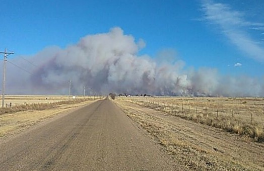
CR34 Fire in southeast Colorado
The CR34 Fire in southeast Colorado 10 miles south of Springfield, Wednesday afternoon February 13, 2019. Baca County Sheriff’s Office photo.

At the top of this page is the HDW prediction for yesterday at the location of the CR34 Fire, showing the predicted index for February 13 above the 95th percentile for that date.

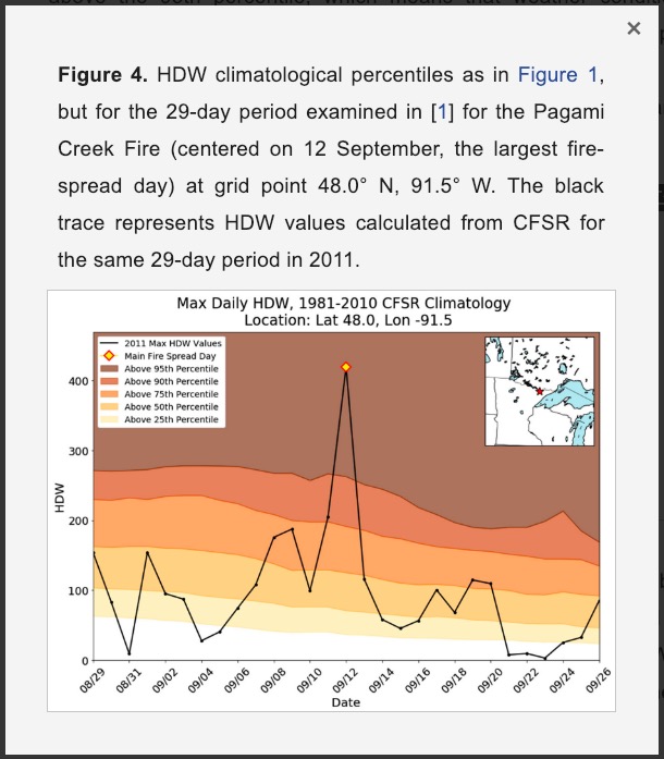
The actual HDW below is centered on the most active day on the Pagami Creek Fire which was managed, rather than suppressed, for 25 days, until it ran 16 miles on September 12, 2011 eventually consuming over 92,000 acres of the Boundary Waters Canoe Area Wilderness in Minnesota. Eight USFS employees were caught out in front of the fire in canoes, with some of them having to deploy fire shelters. Like for the CR34 Fire, the HDW was well above the 95th percentile for the date.
HDW index for Pagami Creek Fire Sept. 12, 2011

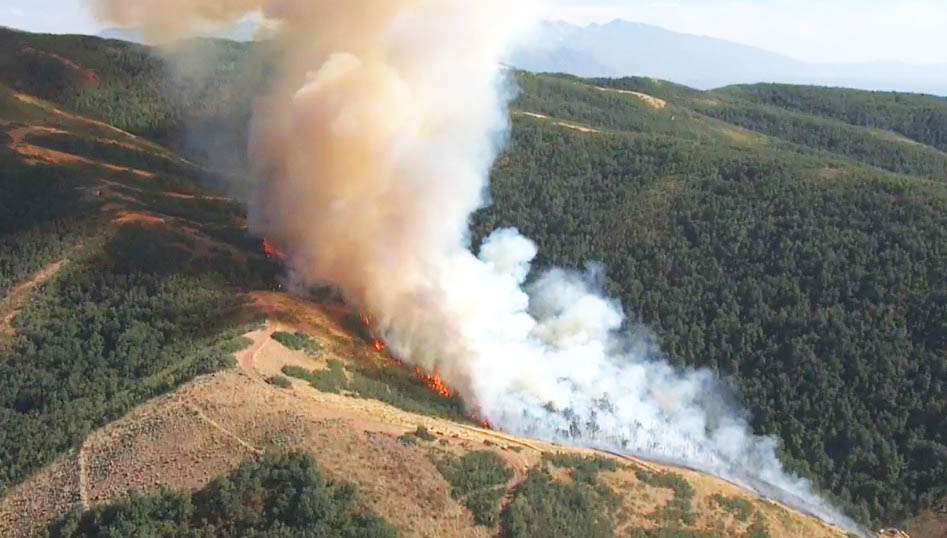
Pagami Creek fire 9-11-2011
Pagami Creek fire September 11, 2011. Photo: Superior National Forest
Pagami fire, Lake Polly 9-12-11 Hans Martin USGS
Pagami fire, Lake Polly, 9-12-2011. Photo: Hans Martin, USGS.

Last year a paper was published about the Hot-Dry-Index, written by Jessica M. McDonald, Alan F. Srock, and Joseph J. Charney.

UPDATE: February 20, 2019: Brian Potter, a research meteorologist with the U.S. Forest Service, provided some preliminary results looking at how HDW performed during the 2017 Chetco Bar Fire in Oregon, as well as how the Haines index performed during that fire.

Tingha, New South Wales isolated as fire closes roads and burns homes

Tingha Fire map bushfire new south wales
The red dots near Tingha, New South Wales represent heat detected by a satellite. NASA image.

Winds in Australia that have changed directions several times in recent days have been pushing a large bushfire in multiple directions. The Tingha Fire that started Sunday in New South Wales has burned around the community of Tingha closing roads in and out of the community. The blaze is between Inverell and Guyra.

NSW Rural Fire Service Commissioner Shane Fitzsimmons said firefighters indicate “numerous properties” including homes, sheds and other outbuildings were damaged or destroyed Wednesday afternoon.

ABC Australia reported that a 40-year old woman was charged with allowing her trash fire to escape, which ignited what has developed into a 30,600-acre (12,400 ha) wildfire.

The Rural Fire Service said winds on Thursday are expected to push the fire closer to Gilgai. Other areas threatened include Old Mill, Stannifer, Guyra Road east of Tingha, and the Howell Road area. But weather conditions on Thursday should be more favorable for firefighters.

On the map below, Tingha is in the center — where two major roads intersect.

Home destroyed in Camp Fire but coin collection found and restored

Joseph Best safe Paradise California Camp Fire
Joseph Best’s photo of his safe that stored his coin collection.

One of the 14,000 homes and businesses that burned in the Camp Fire at Paradise California in November belonged to Joseph Best. During the month evacuated residents were kept out of the burn area he worried about his coin collection that was stored in a “fire proof” safe. When finally allowed back, he found it in the ashes of his home, tipped on its side.

The video below tells the story of how Numismatic Guaranty Corporation, a company that cleans, grades, and packages coins for collectors, extracted Mr. Best’s coins from the melted holders, graded them, and reinstalled the coins in new holders — all at no charge.

Note about “fire proof” safes. The term is misleading. Safes have different levels of fire resistance. Some have more insulating characteristics than others, but if exposed to high enough heat for an extended period of time even the best may allow the inside temperature to rise high enough to damage the contents. Various organizations rate fire resistant safes for time and temperature, for example half an hour at 1,550 degrees, 1 hour at 1,700 degrees, or 2 hours at 1,500 degrees.
Thanks and a tip of the hat go out to Jim. Typos or errors, report them HERE.

Senate passes bill that would enhance the situational awareness of wildland firefighters

Passed on a 92 to 8 vote

On February 12 the Senate passed the Natural Resources Management Act on a vote of 92 to 8. It directs the Secretaries of Interior and Agriculture to implement systems that would enhance the situational awareness capability of wildland firefighters — knowing the real time location of a fire and the resources assigned. This will affect firefighters in five federal agencies: National Park Service, Bureau of Land Management, Bureau of Indian Affairs, Fish and Wildlife Service, and Forest Service.

Sen. Rand Paul
Sen. Rand Paul

A last minute attempt by Kentucky Senator Rand Paul to add an amendment authorizing the sale of some U.S. Forest Service land in his state was shot down.

The bill also includes numerous other actions related to public lands including creating more than 1.3 million acres of wilderness out West, adding three national park units, and expanding eight others.

Now the bill goes to the House of Representatives where it will likely be considered after the mid-February recess.

More details about the legislation.

In settlement man agrees to pay nearly $400,000 for fire in Utah

The fire burned 75 acres near Bountiful, Utah in 2017

Bountiful Fire Utah
Bountiful Fire, August 29, 2017, near Bountiful, Utah. Screenshot from KSL 5 TV video.

A man has agreed to pay $395,914 in a settlement for suppression and other costs associated with the 75-acre Bountiful Fire that started August 29, 2017 near Bountiful, Utah.

The fire ignited on Jayson Ross Orvis’ Bountiful Bench Hillside Hollow Circle property and quickly spread to the adjacent Uinta-Wasatch-Cache National Forest.  It was caused by sparks from a power grinder used by James Golden, who was hired by Mr. Orvis to do work on his property.

The settlement includes a $14,123 payment for environmental remediation costs associated with multiple encroachments on U.S. Forest Service property in addition to the fire damage. Additionally, Mr. Orvis has forfeited $560 for two Forest Service violations that prohibit constructing, placing and maintaining structures without a permit on national forest land. During the fire investigation, it was determined that Mr. Orvis had placed a shooting pavilion and an outfitter tent on the national forest land.

“This settlement fully compensates the public for the expense of fighting the fire and restoring these public lands,” U.S. Attorney John W. Huber said today.

KSL 5 TV shot 20-minutes of video footage from a helicopter not long after the fire started. This is in addition to the 2-minute KSL video below.

Three people sentenced for starting Chateau Fire last summer in Colorado

Three people whose campfire ignited what became the 1,400-acre Chateau Fire seven miles northwest of Cripple Creek, Colorado were sentenced in Teller County District Court last week. Some of the owners of the 11 homes that burned asked for compassion and community service rather than the maximum of 18 months prison time that could have been imposed.

According to The Gazette, Kegan Patrick Owens, 19 and David Michael Renfrow, 24 will serve 60 and 70 days, respectively, in jail. They will both be on probation for 10 years and were ordered to perform 100 hours of community service. A third person who is a juvenile was sentenced to counseling, substance abuse therapy, and 24 hours of community service.

Restitution has not yet been determined, but it could be in excess of a million dollars.

The fire was first reported on June 29, 2018.