Pacific Power lawsuit may come down to fire behavior experts

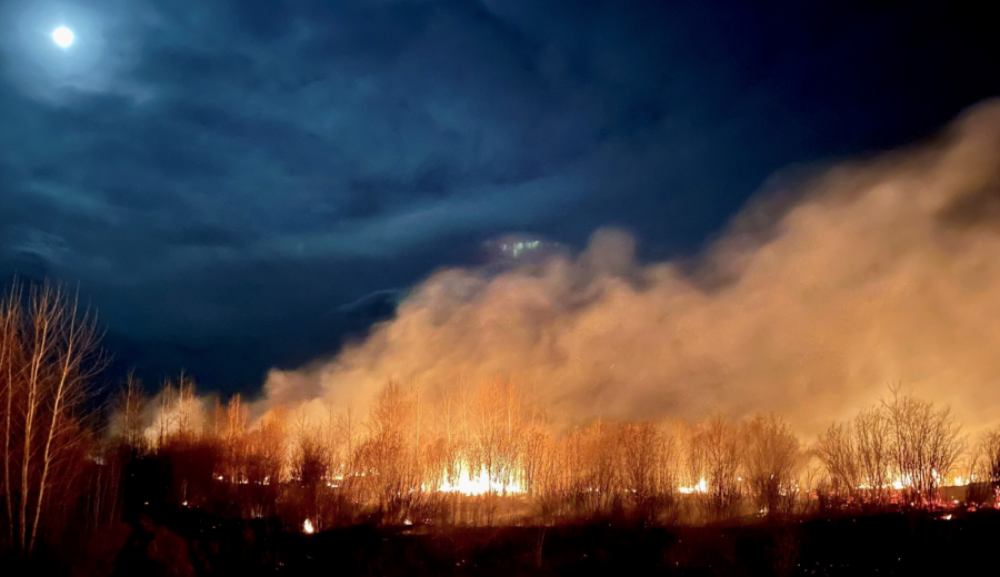
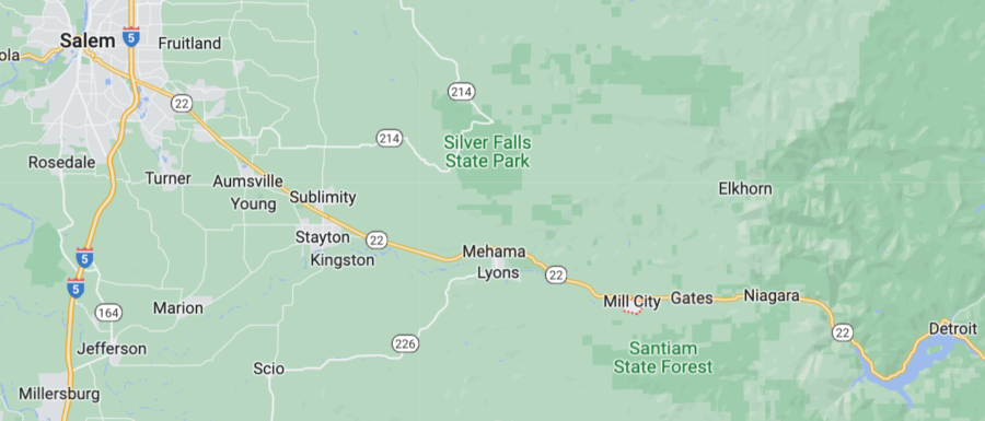
Over the Labor Day holiday in 2020, with east winds picking up toward the end of a long, hot and dry summer, Leland Ohrt was dispatched to a home not far from his own, where a tree branch had fallen on a powerline and started a small brush fire. Ohrt was Mill City Fire Chief, a VFD chief in a small town in western Oregon’s Cascades; he hosed down the fire, then drove over to Schroeder Road, where another tree branch had fallen over another powerline and was still arcing sparks into the dry fuels below. Ohrt couldn’t stop the sparking, so he hosed the utility lines with water until they exploded and de-energized themselves.

Those two incidents initiated a frenzied 48 hours for Ohrt, acccording to an OPB report today, and he was later recognized for his efforts to save Mill City as the fires destroyed thousands of homes down the Santiam Canyon and across other parts of western Oregon.

Chief Ohrt saw Pacific Power’s utility lines start those fires, but he took the stand last week to defend the utility company in a class action trial against Pacific Power. He told a jury in Multnomah County Circuit Court that he immediately blew off attorneys who’d sent him paperwork in the weeks following the fires — lawyers who were trying to contact fire victims.

“I threw all that paperwork away,” Ohrt said. “You could tell right off the bat they were going to go after Pacific Power for this.”

Ohrt’s testimony highlighted a key aspect of the defense Pacific Power’s corporate owners, PacifiCorp, expect to lay out in the coming weeks of the trial: Most of the wildfires in the Santiam Canyon started not from their powerlines, but from embers of the Beachie Creek Fire. Even in places where powerlines did start fires, PacifiCorp’s attorneys contend that people fighting those fires quickly got them under control.

Mill City, Oregon map

The defense follows what has been several weeks of plaintiffs’ attorneys alleging that PacifiCorp acted negligently by keeping its lines energized during the Labor Day fires, even though they had plenty of warning from weather officials and state government about fire danger. The decision to keep the power on contributed to fires spreading out of control, according to the plaintiffs and their attorneys.

Ohrt though, under questioning from PaficiCorp’s lawyers, pointed to another culprit: the U.S. Forest Service. Ohrt has more than 45 years’ experience with Mill City’s volunteer fire department, but he does not have any experience fighting wildfires.

Beachie Creek BAER team map
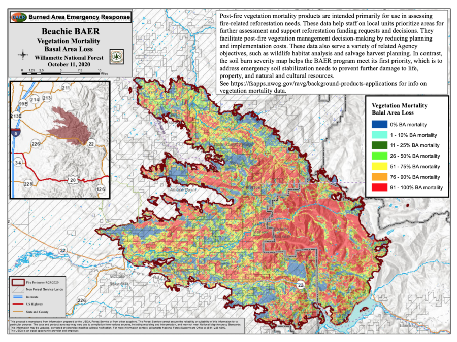
The inciweb images and maps and pages have been retired from the internet, but a few files remain on the Willamette NF site.

Weeks before the Santiam Canyon fires, a lightning strike started the Beachie Creek Fire — northeast of Gates in the Opal Creek Wilderness. Forest Service officials said then that steep terrain made it difficult to get crews to the site to contain the slowly growing fire. According to Ohrt, though, letting the Beachie Creek Fire smolder allowed it to throw embers into the Santiam Canyon when winds picked up on Labor Day.

2020 Beachie Creek Fire
Beachie Creek Fire August 27, 2020, just 11 days after it started, before it grew very large on September 8. USFS photo.

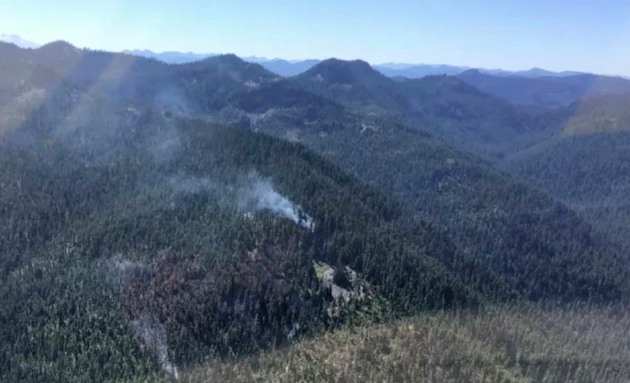
An excellent “storymap” about the Beachie Creek Fire is [HERE].

“The U.S. Forest Service was supposed to be fighting that fire,” Ohrt said in his testimony.

Late in 2020 Linn County had to sue the Forest Service to get fire documents.

The Type 3 IC at the time knew that air support was critical, according to a USFS review of the fire, but he also recognized that the fire was burning in an old growth stand, meaning there was a multistory canopy with abundant down logs, duff, moss, and fuels. He knew that getting firefighters on the ground to dig deep for hotspots was the only way to successfully contain the fire.

“Everyone assumes that if you hammer a fire with aerial resources, it will go out, but that’s not the case. There needs to be boots on the ground working in tandem with aircraft. There are hidden hotspots, sheltered from aerial attack, under big logs and deep roots that have to be dug out.”
~ unnamed Type 3 Incident Commander

Whether jurors in the case find PacifiCorp responsible for the wildfires in the Santiam Canyon will likely be influenced by which attorneys’ experts they find more believable. Oregon State University professor John Bailey, for example, testified that there was no way the Beachie Creek Fire could have thrown embers far enough before midnight on Labor Day 2020 to start fires near the town of Gates. Bailey, who teaches fire management and has been studying forestry since the 1980s, said he used topography data, recorded weather conditions, and fuels analysis to estimate where the Beachie Creek Fire could have thrown embers ahead of its front to start new fires. He said strong east winds that night would have — at most — lit spot fires north of Gates and other residential areas in the canyon.

PacifiCorp’s attorneys, on the other hand, had atmospheric sciences professor Neil Lareau of the University of Nevada testify, and he said the extreme weather conditions that night did indeed throw firebrands miles ahead of the Beachie Creek Fire. Lareau explained to jurors how he used satellite data from the fire to determine when plumes of debris burst from the fire and cast embers thousands of feet aloft. He said those plumes matched up with on-the-ground reports of spot fires in the Santiam Canyon. Bailey, by contrast, said embers thrown by fires can rarely travel more than a mile — a far shorter distance than needed to start the fires Lareau claimed originated from the Beachie Creek Fire.

Alberta firefighters hoping for weather change

Several regions in the U.S. are suffering from poor air quality as smoke from wildfires in Canada drifts south. Much of the of the U.S. has experienced smoky skies for days, creating unhealthy conditions for residents with heart or lung conditions. ABC News reports that the National Weather Service issued an air quality alert for all of Montana, along with parts of Idaho, Colorado, and Arizona. In Utah, the Department of Environmental Quality urged residents on Friday to avoid outdoor activities in places with visible smoke and haze. Heavy smoke began to pour into northeastern Colorado on Friday.

Alberta Wildfire
Alberta Wildfire

Reuters reported that Alberta authorities hope cooler temperatures and showers forecast for the coming week will help firefighters in the oil-rich Canadian province, although storms could complicate efforts. Forecasters are tracking a front likely to move into Alberta on Sunday that could bring cooler weather. Christie Tucker, information unit manager at Alberta Wildfire, said Saturday the front could mean increased humidity or even rain.

“What we’d like to see is a long steady rain that will soak into the forest and into the ground,” Tucker said. “That will help us more than a short burst that would bring lightning and could spark a new wildfire.”

airnow.gov fire and smoke map

Alberta has endured energy production cuts, residential evacuations, and poor air quality after an intense start to the wildfire season. This year, Alberta Wildfire has responded to 496 wildfires burning more than 842,000 hectares, compared with just 459 hectares in 2022.

“This year’s total is nearly 2,000 times last year,” Tucker said. Over 2,800 firefighters from Canada and the United States were fighting 91 active fires on Saturday.

Canada’s wildfires have sent smoke to U.S. states including Minnesota, Nebraska, Illinois, Wisconsin, Wyoming, Utah, Washington, and Colorado, triggering air quality alerts in several places.

The air quality index on the Front Range in Colorado reached 168 on Friday, according to the state’s Department of Public Health and Environment. A reading between 151 and 200 indicates unhealthy conditions that affect sensitive groups as well as the general public, health officials say. Idaho also saw widespread haze earlier in the week, according to the state’s Department of Environmental Quality.

Rain forecast for western Canada

Western Canadian communities and firefighters may catch a welcome break next week with a forecast for precipitation — perhaps a good amount. Over the next week, areas along the Canadian Rockies may receive more than 100 mm (3.9 inches) while the Alberta-Saskatchewan border area may receive 20 mm (less than an inch), with soil moisture predicted to rise throughout the fire-impacted areas. This will likely slow fire spread and smoke volume, though fires at such scale will continue to produce smoke. An overall increase in humidity should lower fire danger.

The western provinces have experienced weeks of active fire behavior and growth, with an intensity comparable to that seen in the 2016 fires that burned Fort McMurray, Alberta and the heat domes and fires of 2021, when fires burned Lytton, British Columbia.

Precipitation forecasts from the National Center for Environmental Prediction

Phys.org reported that some 2,500 firefighters from across Canada backed by 400 military personnel have been deployed across Alberta and that more foreign help has been requested — with crews and incident management teams from the United States, Mexico, Australia, and New Zealand.

At one point nearly 30,000 Alberta residents were evacuated from their homes. Hazardous air quality and low visibility due to smoke were reported from British Columbia to Saskatchewan and as far south as Colorado and northern Texas.

PM2.5 average05/21 map
PM2.5 average
05/21 map

Situation Reports – National

The home page of the Canadian Wildland Fire Information System features maps of weather, fire behavior, and hot spots.

The Canadian Interagency Forest Fire Center Situation Report for May 20 indicated area burned to-date of 2.1 million hectares (nearly 5.2 million acres), with 15 new fires for a total of 226 currently active fires. Of those fires, 90 are identified as out of control. Canada is in its tenth day at its highest preparedness level of 5.

Situation Reports – Provinces with highest fire activity

Climate Change and Fire

In the Climate Atlas of Canada, an article on “Forest Fires and Climate Change” examines the impacts of climate change on Canadian fires and summarizes studies by Mike Flannigan and other scientists who predict that by 2100, western Canada will see a 50 percent increase in the number of dry, windy days that let fires start and spread, whereas eastern Canada will see an even more dramatic 200 percent to 300 percent increase in this kind of fire weather.  And by 2040, fire management costs are expected to double.

Flannigan, a professor of wildland fire at the University of Alberta, explores the impact in more detail on his website. “Fire is the major stand-renewing agent for much of the Canadian forest,” he says, “greatly influencing forest structure and function.”

The research he summarized indicates that the observed increases in area burned in Canada during the last four decades is the result of human-induced climate change. Additionally, he says it appears that temperature is the most important predictor of area burned in Canada with warmer temperatures associated with increased area burned.

Based on a 2005 analysis, Flannigan says current estimates are that an average of over 2 million hectares burn annually in Canada. Just shy of the third week of May, Canada has already recorded 2.1 million hectares burned.

Oregon gears up for 2023

Posted on Categories PreventionTags ,

Fire season is already under way in Oregon, with some small fires burning in the southwest part of the state, and state and federal officials are talking about options for funding firefighting efforts.

On May 17, Governor Tina Kotek announced she was adding over $200 million in funding for the state’s wildfire protection system to her budget request to the state legislature. “We need to continue to support things that have worked,” Kotek said in a press conference covered by KEZI-TV. “We need another $207 million to continue our advancements in wildfire protection, in both resilience and protection and response, and I would hope legislators would support that.”

ODF Fire
Oregon Dept. Forestry

In Washington, D.C., Oregon Senators Jeff Merkley and Ron Wyden are working on legislation to create national recreation areas across the state. That distinction would require wildfire prevention strategies in the region. “The bill requires the Bureau of Land Management to take preemptive steps to reduce wildfire risks in the new recreation areas,” Wyden said at a Senate committee hearing, “including the construction of new roads to implement fire risk reduction plans and for public safety.”

Fire departments and districts have also received additional funding for firefighters, engines, and risk reduction programs. Much of that funding comes from 2021’s Senate Bill 762.

“Senate Bill 762 was a major investment in in fighting wildfire in Oregon, and it was a huge help for not only the Oregon Department of Forestry but other wildfire agencies in the state,” said Jessica Prakke, PAO with the Oregon Department of Forestry. The legislation provided $220 million to agencies to modernize and improve wildfire preparedness, response, and resiliency. “It was a huge investment in protecting Oregon from wildfire and it has done an immense amount of good across the state,” she said.

She said the funding also expanded the state’s network of wildfire detection cameras. One such camera caught a fire caused by a lightning strike in Lane County. On the night of May 15 a camera alerted ODF staff to smoke in between Sharps Creek and Mosby. A staffer monitoring the cameras dispatched fire crews to the site, and they had the fire under control within three hours. Prakke said there are now nearly 100 cameras at 60 sites across the state. The system also uses a mapping system to help pinpoint smokes for dispatchers and first responders.

Prevention is the key for a successful season, said Prakke. “The best way to stop wildfire is for people to keep wildfire prevention at the top of their mind,” she said. “About 70 percent of all wildfire in Oregon is human-caused, and so the less that we can contribute to wildfire on our parts, the less our resources are strained to fight other causes of wildfire.”

California’s ALERT camera network now publicly accessible

Cal Fire and other agencies are using a network of over 1,000 cameras across California to track wildfires — and now the public can access the network, too. FOX News reports that the University of California San Diego and state fire agencies have partnered to launch a public website for people to view live camera feeds from across the state.

ALERTCalifornia camera network

ALERTCalifornia uses a network of more than 1,000 live cameras to track fires. “We’re trying to understand the impacts, the cascading disasters after these events,” said Dr. Neal Driscoll, a professor of geology and geophysics at the UC San Diego Scripps Institution of Oceanography in La Jolla, California. “I’m a professor. I study earthquakes, I make sensors, and here these sensors lend themselves to other events, such as atmospheric rivers and wildfires.”

View live feeds here: cameras.alertcalifornia.org

As the ALERTCalifornia camera network grows in size and sophistication, UC San Diego researchers are using new technology to study natural disaster patterns in the West. ALERTCalifornia provides state-of-the-art technology supporting data-driven decisions to prepare for, respond to, and recover from natural disasters. Based at the University of California San Diego, ALERTCalifornia is a public safety program focused on fires and other natural disasters featuring a world-class camera network.

“These cameras are on mountaintops that we can access, and so if we get a 911 call from someone reporting smoke, we can — one click away — just get on the computer and see if there is actually any smoke in the area,” said Capt. Brent Pascua, PIO with Cal Fire. “We can use multiple cameras to pinpoint the location and get a better location as well.”

“Five or six years ago they had to send a battalion out or an aircraft to confirm ignition,” says Driscoll. “Now they can turn to our cameras. They can immediately move the camera, and image that area, and confirm ignition.” The high-definition cameras can pan, tilt and zoom, with a view as far as 60 miles on a clear day and 120 miles on a clear night, according to Scripps Institution of Oceanography. New cameras were recently installed in Los Angeles, Santa Barbara, and Madera counties since the new year.

Sutter Buttes camera today

Only fire agencies can control the movement of the cameras, which are placed on tripod platforms that can be removed seasonally with little to no impact on sensitive habitats or tribal lands. The camera network started 20+ years ago in 2000, with numerous improvements to the technology over time. The network was originally created to study earthquakes. Since then, it’s expanded to monitor fires and other natural disasters. Public access to the camera feed was launched last week.

International meeting opens with fire problem, community solutions

PORTO, Portugal – The opening morning of the Eighth International Wildland Fire Conference featured a range of civil leaders, fire managers, and scientific experts who helped circle the delegates around the dilemma of wildland fire: it is the problem and also (sometimes, but not always) the problem’s solution.

How a problem can be its own solution – the fire conundrum – is part of what drew some 1600 delegates from 90 countries to Porto, Portugal in mid-May.

The week-long conference included technical field trips on May 15 and the official opening May 16, followed by a keynote session labeled simply “The Problem.”

The opening included a videotaped welcome from António Guterres, the United Nations secretary-general, who cautioned that “We must keep global warming below 1.5 C” and if we’re to do so, he said, we must energize fire management that includes all voices, including indigenous leaders and communities. (And even though we must act to limit climate change, a UN World Meteorological Organization report this week has forecast a 66 percent chance we’ll reach the 1.5°C increase for a year during the next five years.)

The conference chair, Tiago Oliveira, board chairman of Portugal’s wildfire service Agency for Integrated Rural Fire Management (AGIF), opened with guidance: “We need to take out the emotional side of fire and replace it with  the rational management of fire.” Yet he also reminded attendees of the emotional reality of wildland fire. “I am a survivor as many of you are and we are here to build a better future. To ask for help as I did in 2017” – when Portugal endured a storm of fires that killed 120 citizens and firefighters. An article in Scientific Reports suggests that the extreme fire season of 2017 may have been a prelude to future conditions and likewise events that are triggered by climate change effects. The immensity and challenge of these fires also led to the creation of AGIF.

“Every day that we are managing fires we are learning,” Oliveira continued. “We come here to build friendships in fire. The more friends we have in the world of forest fires the more successful we will be. And the world needs our contributions. The world needs less bad fire and more good fire.”

Tiago Oliveira, board chairman of Portugal’s wildfire service (AGIF) and conference chair opens the Eighth International Wildland Fire Conference.

Gordy Sachs, chief of All Hazard and International Fire Support for the U.S. Forest Service and chair of the International Liaison Committee that planned the conference, reiterated the conference’s value globally. Statements from prior conferences [held every four years] influenced Sendai Framework for Disaster Risk Reduction and the Paris Agreement on climate, and the 2023 Conference will launch a key transition tool for international cooperation – the Landscape Fire Governance Framework – and will, like prior conferences, make each country and the world safer and more resilient.

Most of the opening, as is typical of international gatherings, offered the sort of civil and governance support that is key to implementing new frameworks. So it was heartening (if also disheartening) to learn from Antonia Cunha, president of Portugal’s North Regional Coordination and Development Commission, that he’s aware and concerned that 26 percent of carbon emissions in 2022 in the region was from forest fires.

Likewise, a commitment from Juan Cabandié, Environment Minister of Argentina, highlighted that his country needs to be more directed at planning and prevention. “We’re the eighth largest country in the world and 70 percent of our land at risk of wildfires,” he said. And to support its goals, Argentina has started its first monitoring system for entire country.

Duarte Cordeira, with Portugal’s Ministry of Environment, also returned the delegates to community. “We know that the best fire management is by the community members. If we want a more resistant forest that can provide economic and sustainable benefits, we cannot have a monoculture. We are increasing our defense with the creation of a protection ring of native forest.” He said already 200 of these native fuel breaks have been planted, with another 470 in the works and a goal of 800 villages. And Cordeira noted the challenge. “Yet 97 percent of rural properties are private,” he said, “so we need to increase subsidy for land consolidation.”

A conference opening offers a frame, and after a break for coffee and Pastéis de Nata, the conference jumped into “The Problem.” More on that soon.