New fire pushes smoke into northwest Washington

The Bolt Creek Fire near Skykomish is growing rapidly

Updated 8:50 a.m. PDT Sept. 11, 2022

Bolt Creek Fire map at 8:21 pm Sept. 10, 2022
Bolt Creek Fire, mapped by a fixed wing aircraft at 8:21 pm Sept. 10, 2022

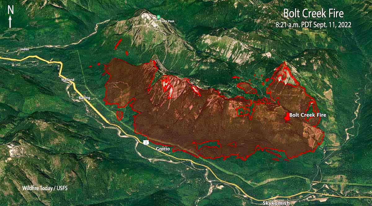
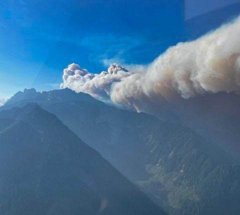
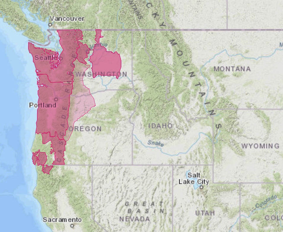
The Bolt Creek Fire 42 miles north-northeast of Seattle is producing smoke that is moving into Everett and Bellingham. The fire spread eight miles to the northwest after it started Saturday near Skykomish off US Highway 2. So far it has remained north of the highway as it burned past Grotto and Baring. A US Forest Service mapping flight Saturday night determined it had blackened about 7,660 acres and was 3 miles southeast of Index. This data from a fixed wing aircraft is much more accurate than some of the maps being posted on social media.

To see all articles on Wildfire Today about the Bolt Creek Fire, including the most recent, click HERE.

An 18-mile corridor of Highway 2 remains closed and evacuations are in effect. Snohomish County has the details.

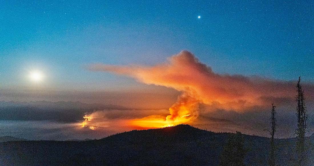
This kind of wildfire activity is exceptionally rare for the western slopes of the central Cascades in Washington.

Satellite photo, Bolt Creek and Cedar Creek fires Sept. 10, 2022
Satellite photo, Bolt Creek (on the north) and Cedar Creek fires Sept. 10, 2022. Processed by Pierre Markuse.

Two hikers that were on the mountain had a harrowing escape from the fire. They called 911 and were told it was too dangerous to rescue them by helicopter, but eventually after scrambling down steep terrain they made it out of danger. (Update, Sept. 13, 2022: the hikers documented their escape from the fire.)


3:47 p.m. PDT Sept. 10, 2022

Bolt Creek Fire near Skykomish, Washington at 1:54 p.m. PDT September 10, 2022
The red dots represent heat detected by a satellite on the Bolt Creek Fire near Skykomish, Washington at 1:54 p.m. PDT September 10, 2022. The extent of heat displayed may be exaggerated. The fire, at that time, may not have been as large as depicted here.

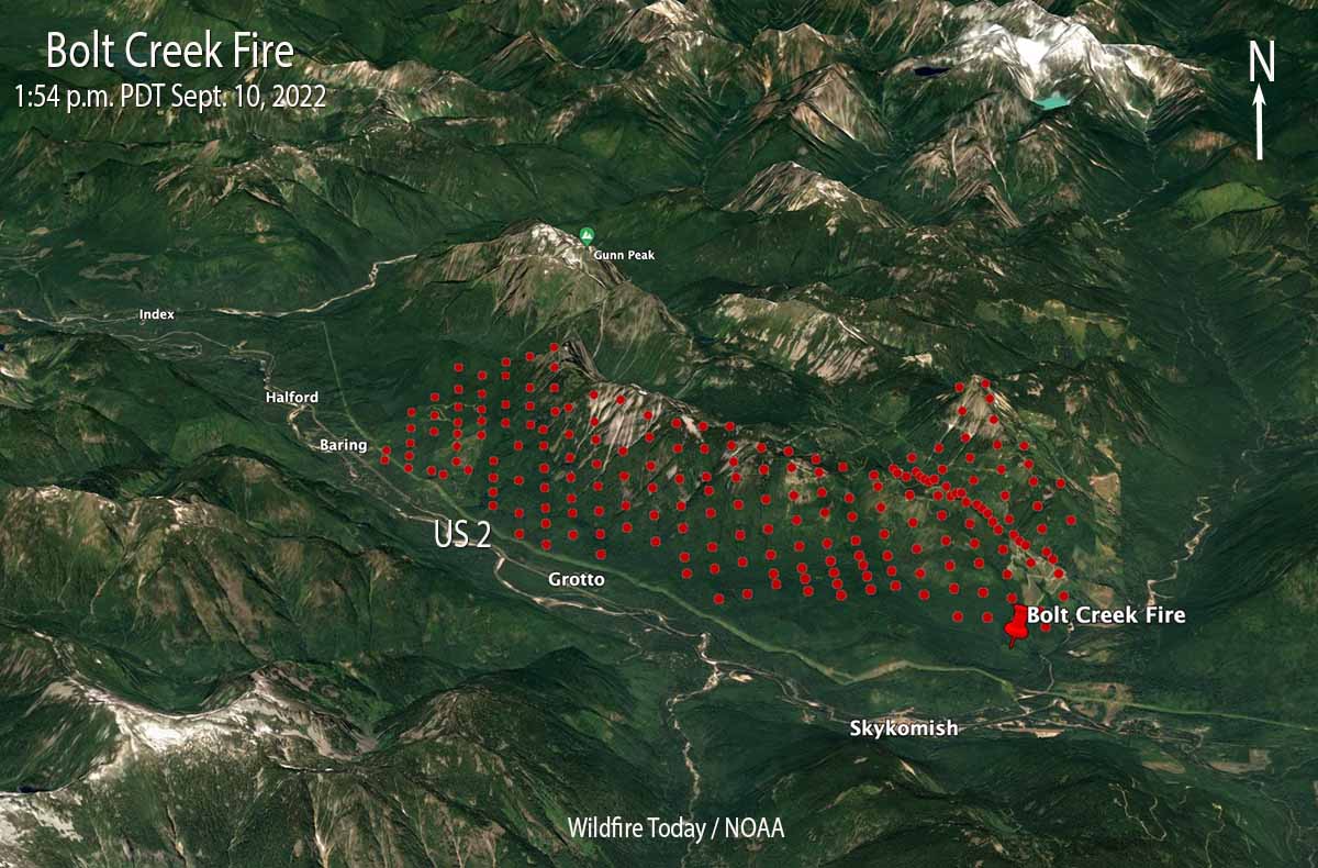
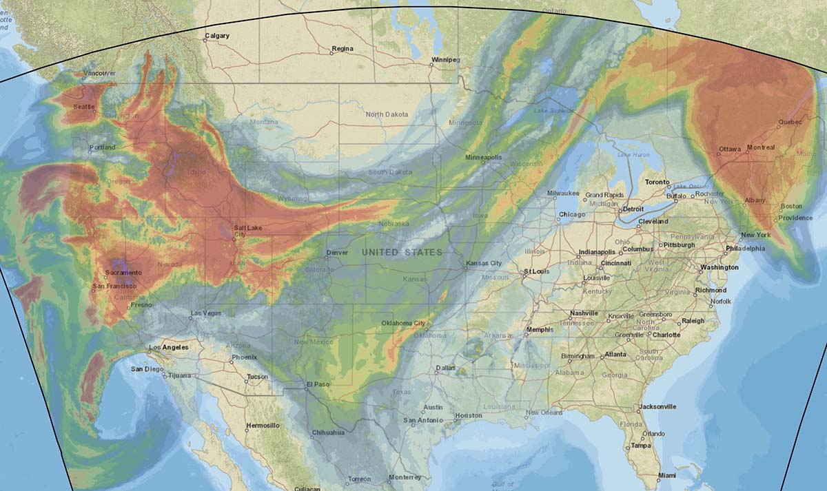
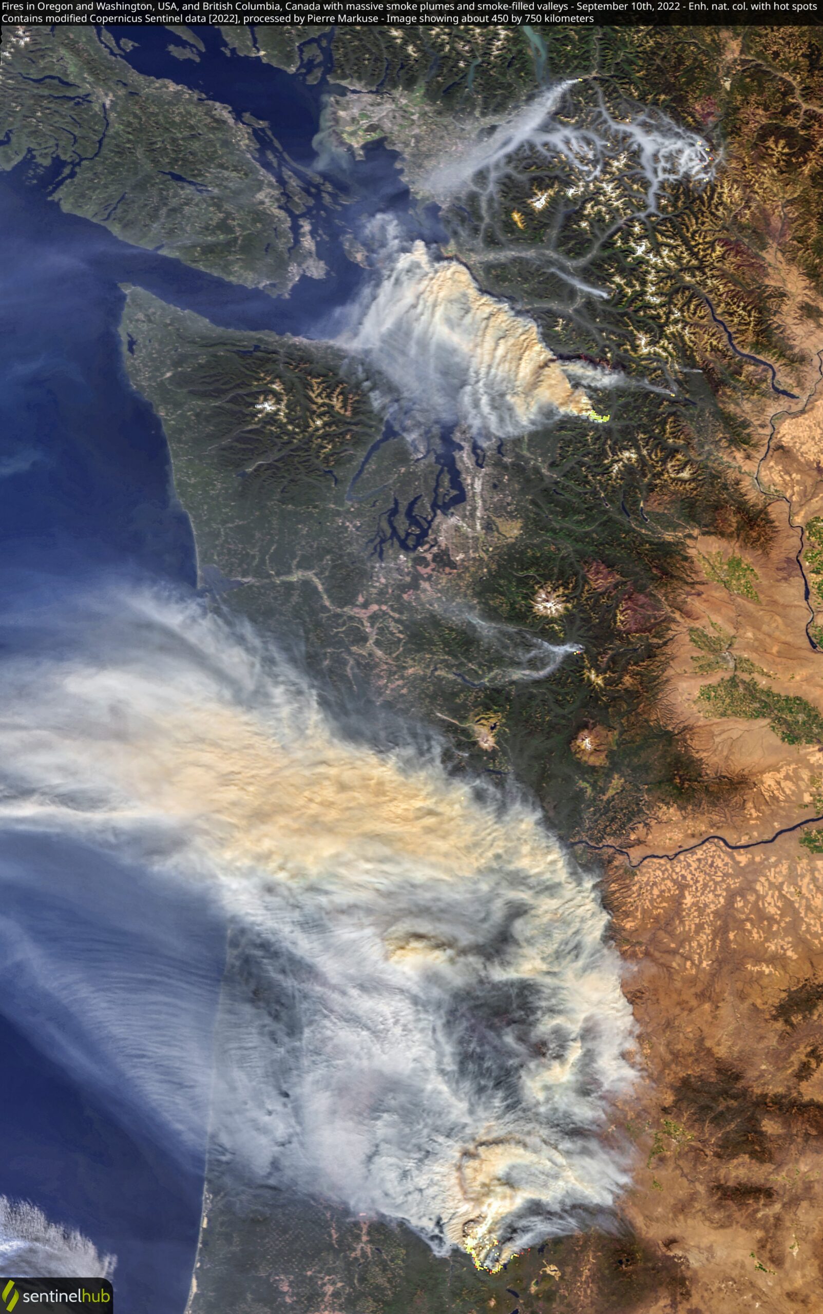
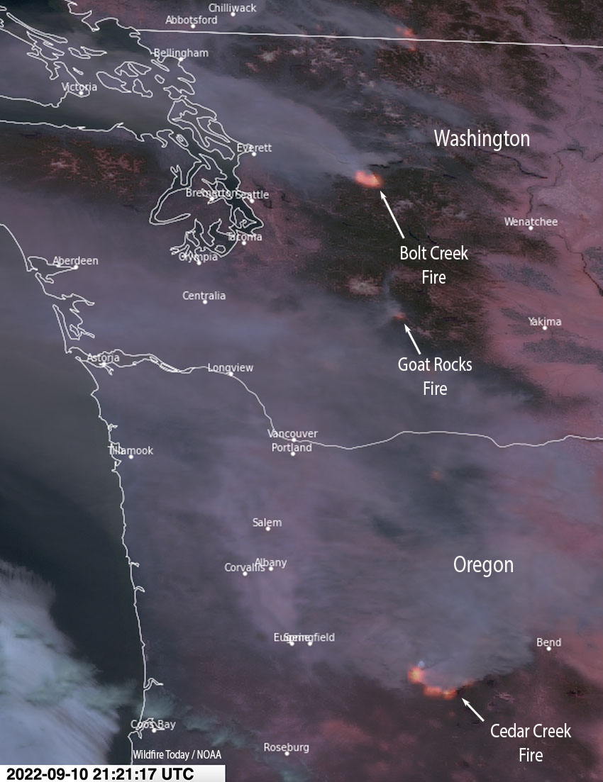
Several wildfires are pushing smoke into western Oregon and Washington. The Bolt Creek Fire, which started Saturday in northwest Washington near Skykomish off US Highway 2 is growing very quickly. It is producing a great deal of smoke blowing to the northwest toward Everett and Bellingham.

Bolt Creek Fire, September 10, 2022. Washington State DNR.

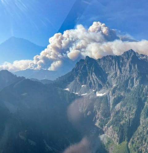
Our very, very rough estimate of the size, based on the imprecise satellite heat data, is that the Bolt Creek Fire had burned more than 2,500 acres by 1:54 p.m. PDT Saturday.

Satellite photo showing smoke from fires in Washington and Oregon
Satellite photo showing smoke from fires in Washington and Oregon, 2:21 PDT Sept. 10, 2022.

A section of Highway 2 is closed.

Snohomish County has evacuation information about the Bolt Creek Fire.

A fire south of Mount Rainier National Park, the Goat Rocks Fire, is also producing smoke, but it is heading generally west to the Centralia area. As of Friday it had burned about 1,500 acres.

The smoke from a very large fire that has been burning since August 1 in west-central Oregon, the Cedar Creek Fire, is sending smoke into Washington. The Washington State DNR said today that smoke from that 35,000-acre fire is being lofted to higher altitudes and is not expected to contribute significantly to further reductions in air quality at ground level. It will actually help keep temperatures down a few degrees Saturday afternoon, they said, and limit the minimum relative humidity values experienced in the Puget Lowlands.

Bolt Creek Fire, September 10, 2022. Washington State DNR.

Rain from tropical storm Kay slows spread of Southern California fires

Precipitation, vicinity of Fairview Fire,
Precipitation, vicinity of Fairview Fire, 24 hours ending 5 a.m. Sept. 10, 2022

Rain that began falling at about 1 p.m. Friday slowed the spread of the Fairview and Radford Fires in Southern California. By 5 a.m. Saturday weather stations near the fires had recorded amounts ranging from 0.05″ to 0.28″.  Much higher amounts were found at a few locations in the mountains east of the Fairview Fire.

The precipitation is expected to continue into Sunday morning.

Precipitation, vicinity of Radford Fire,
Precipitation, vicinity of Radford Fire, 24 hours ending 5 a.m. Sept. 10, 2022
Fairview Fire map Sept. 10, 2022

There was a concern that very strong winds generated by tropical storm Kay would cause problems at the fires, but those did not materialize, at least not by 5 a.m. Saturday.

Precipitation, Southern California, 24 hours ending 5 a.m. Sept. 10, 2022

As of 5 a.m. the rain had occurred as far north as Santa Barbara and Edwards Air Force Base. It did not affect the rapidly growing Mosquito Fire 27 miles west of Lake Tahoe, CA.

Meanwhile, Red Flag Warnings are in effect Saturday for the northwest corner of California and the west sides of Washington and Oregon.

Red Flag Warnings September 10, 2022

The forecast for vertically integrated wildfire smoke predicts impacts in most of the Western States Saturday afternoon.

Forecast for smoke
Forecast for smoke at 1 p.m. MDT Sept. 10, 2022. NOAA

A quick look at seven fires in the Central Idaho area

Map of fires, central Idaho, Sept. 9, 2022
Map of fires in central Idaho, Sept. 9, 2022.

With 35 large uncontained wildfires currently burning in the United States, and many, many more in various categories, we can’t report extensively on all of them, so today we will take a slice of geography and look briefly at seven fires spreading in the Central Idaho area, and extend it just a bit into Oregon and Montana.

Moose (Idaho)
The largest of these seven fires is the Moose, which has been chewing through eastern Idaho since July 17. As far as the cause, the Salmon National Forest says, after almost two months, it is “human caused,” which only eliminates the causes of volcano and lightning. Nine structures have been destroyed. On Friday 650 personnel are assigned to the 125,000-acre blaze which is 5 miles northwest of Salmon, ID. A satellite overflight Friday afternoon only found large heat sources in the southeast portion and that is where an additional 15,000 acres burned Wednesday night, prompting evacuations near Salmon.

Crews reengaged the fire and began preparing new contingency lines along the west edge of the city. Several water pumps, five log decks, and some portable water storage tanks (nicknamed pumpkins because of their shape and color) were destroyed Wednesday.  No firefighters were injured. Nearly 500 acres of the city’s Municipal Watershed burned that night, something the various incident management teams had been trying to protect since July.

Cooler temperatures, higher relative humidity, and thick smoke contributed to minimal fire behavior across the fire Thursday.

Indian Ridge (Idaho)
Northwest of the Moose Fire near the Montana border is the lightning-caused 8,670-acre Indian Ridge Fire on the Bitterroot National Forest. It is in the Selway-Bitterroot Wilderness 30 miles southwest of Darby, Montana. The fire has been active this week primarily along the western and northern flanks and north of Indian Creek as it burns through steep, rugged, remote terrain with heavy surface fuels and dead standing timber.

Indian Ridge Fire
Indian Ridge Fire the night of August 18, 2022. InciWeb.

The fire is not being fully suppressed. Their daily reporting says, “Fire managers are utilizing a point protection strategy to prevent any critical wilderness infrastructure from being negatively impacted by the fire.”

Dismal and Patrol Point
These two fires are very close to merging after significant growth since September 6, and combined have burned an estimated 23,000 acres. They are about 50 miles northwest of Salmon, Idaho. Smoke and the unavailability of infrared mapping aircraft have made it difficult to determine the current perimeters, but there is a lot of new burned acreage between the two fires. Recent low humidity and strong winds are in part responsible for the recent growth.

Areas that fire managers intend to protect include Cold Meadows Guard Station, Root Ranch, and Lantz Bar.

Fire personnel on the Williams Creek Fire
Fire personnel on the Williams Creek Fire in Idaho. InciWeb, posted 9-8-2022.

Williams Creek
The 11,881-acre fire is 5 miles west of Orogrande, near Wildhorse Lake, 7 miles southwest of Elk City, and 8 miles north-northwest of Dixie.

“Resources will continue to engage the fire in Orogrande and the Crooked River corridor, addressing and extinguishing hot spots and conducting damage assessments,” said a September 9 update from the Incident Management Team. “The fire and associated winds did impact structures and outbuildings; crews are still assessing the extent of the damage. Fallen trees, burned snags, and downed power lines continue to present safety hazards.”

Double Creek (Oregon)
The 137,000-acre lightning-caused Double Creek Fire is in Oregon just west of the Idaho border. It has burned to the Snake River in the Pittsburg Landing area. A River Group has been established to assess and protect structures along the waterway. The fire is being fully suppressed and crews are looking for locations to establish the control line farther from Lower Imnaha Road where topography allows. Two structures have been destroyed.

Trail Ridge (Montana)

The 13,000-acre Trail Ridge fire is on the Beaverhead-Deerlodge National Forest in Western Montana about 5 miles east of the Idaho Border and 4 miles southeast of Sula, MT. The cooler weather experienced Thursday and Friday was helpful in slowing the spread of the fire and decreasing the severity of fire behavior. It is burning above 7,000 feet elevation near the Continental Divide and there is no current or expected threat to private land and property. It is not being fully suppressed.

Military activates two MAFFS air tankers to join fire fight

MAFFS training, Boise, April 21, 2017
MAFFS training, Boise, April 21, 2017. Photo by Bill Gabbert.

The National Interagency Fire Center (NIFC) has requested two Department of Defense C-130 aircraft equipped with Modular Airborne Fire Fighting Systems (MAFFS) to support wildland firefighting operations in support of NIFC in the northwestern United States. One C-130H from the Nevada Air National Guard’s 152nd Airlift Wing, Reno, Nev., and one C-130J from the California Air National Guard’s 146th Airlift Wing, Port Hueneme, Calif., will arrive at Boise Airport in Idaho today. The aircraft are standing by for flying on behalf of a DoD-approved US Forest Service Request.

“We greatly appreciate the assistance of our military partners,” said Kim Christensen, deputy assistant director for operations for the US Forest Service. “These aircraft will help provide additional capacity for aerial firefighting.”

Having military C-130s that can be converted into air tankers provides a critical “surge” capability that can be used to bolster wildfire suppression efforts when commercial air tankers are stretched thin or an inadequate number remain available for initial attack.

Nationally there are 35 large uncontained wildfires being managed by 26 Type 1 or 2 incident management teams. As of Friday morning 156 helicopters are committed to fires along with more than 17,000 personnel. The number of contracted large air tankers activated was 23, plus 6 water scooping air tankers, before the 2 MAFFS came on board.

inside of a MAFFS air tanker retardant tank
Looking at the inside of a MAFFS air tanker, the retardant tank and one of the compressed air tanks. Photo by Bill Gabbert.

Firefighters working to save structures in the Mosquito Fire in Northern California

It has burned tens of thousands of acres near the community of Foresthill

Updated 9:41 a.m. PDT Sept. 10, 2022

Mosquito Fire map 11:45 p.m. PDT Sept. 9, 2022
Mosquito Fire map 11:45 p.m. PDT Sept. 9, 2022. The white line was the perimeter about 24 hours before. The orange areas represent intense heat.

The Mosquito Fire at Foresthill in Northern California was very active again Friday, but did not spread as much as in recent days. That was due to the overnight and morning inversion layer dissipating later than usual and very little wind, ranging from calm to three mph Friday and Friday night. The temperature was 93 degrees and the minimum relative humidity was 21 percent.

The forecast for Saturday is 88 degrees, afternoon winds out of the southwest at 8 mph, 50 percent cloud cover, and 27 percent relative humidity. Sunday should be about the same.

Despite the moderate weather conditions, on Friday there was incremental growth on most of the perimeter except for along Foresthill Road and the area 1 to 5 miles east of Volcanoville. At its widest point the fire is 12 miles long.

The fire was mapped Friday night at 33,753 acres.

The Incident Management Team plans to provide structure defense and point protection for values at risk and protect private timberlands.

The map below shows fires in the National Interagency Fire Center database that have occurred in the area since 1990. It appears possible that under extreme weather and fuel conditions the fire could spread significantly to the east or northeast. The Mosquito Fire about 6 miles from the 2014 King Fire and 28 miles from Lake Tahoe.

Mosquito Fire, area history
History of fires in the Mosquito Fire area, 1990 to 2021. NIFC / Wildfire Today.

11:55 a.m. PDT Sept. 9, 2022

Mosquito Fire map 11:04 a.m. PDT Sept. 9, 2022
Mosquito Fire map 11:04 a.m. PDT Sept. 9, 2022.

Firefighters have been working hard to save structures in the Foresthill area as the Mosquito Fire grows larger. Early unofficial reports say they were successful.

Most of the movement is to the east and southeast, but it has also been spreading west into the community of Foresthill and has moved into El Dorado County. It was mapped at about 11 a.m. Friday at 29,585 acres.  Friday morning the area is thick with heavy smoke, preventing tactical aircraft from flying.

Cameras were able to provide images of the fire into Thursday night until smoke obscured the view.

Mosquito Fire
Mosquito Fire, looking northeast from the Bald Mtn Eldorado camera at 1:28 a.m. Sept 9, 2022.

Fire officials are aware of damage to structures in the Michigan Bluff area, and possibly other locations, and will survey the effects when it can be done safely.

The status of evacuations has changed. Placer County has a map showing evacuation orders and warnings. El Dorado County also has a map.

The blaze exhibited extreme fire behavior Thursday, forming huge rotating convection columns.

Wildfire smoke and red flag warnings for September 9 and 10

Smoke forecast for 2 a.m. MDT Sept. 10, 2022.
Forecast for vertically integrated smoke at 2 a.m. MDT Sept. 10, 2022.

Smoke from wildfires is expected to affect most of the Western United States Friday and Friday night.

Red Flag Warnings for extreme fire danger on Friday are posted for areas of Washington, Oregon, and California.

Red Flag Warnings, Sept. 9, 2022.