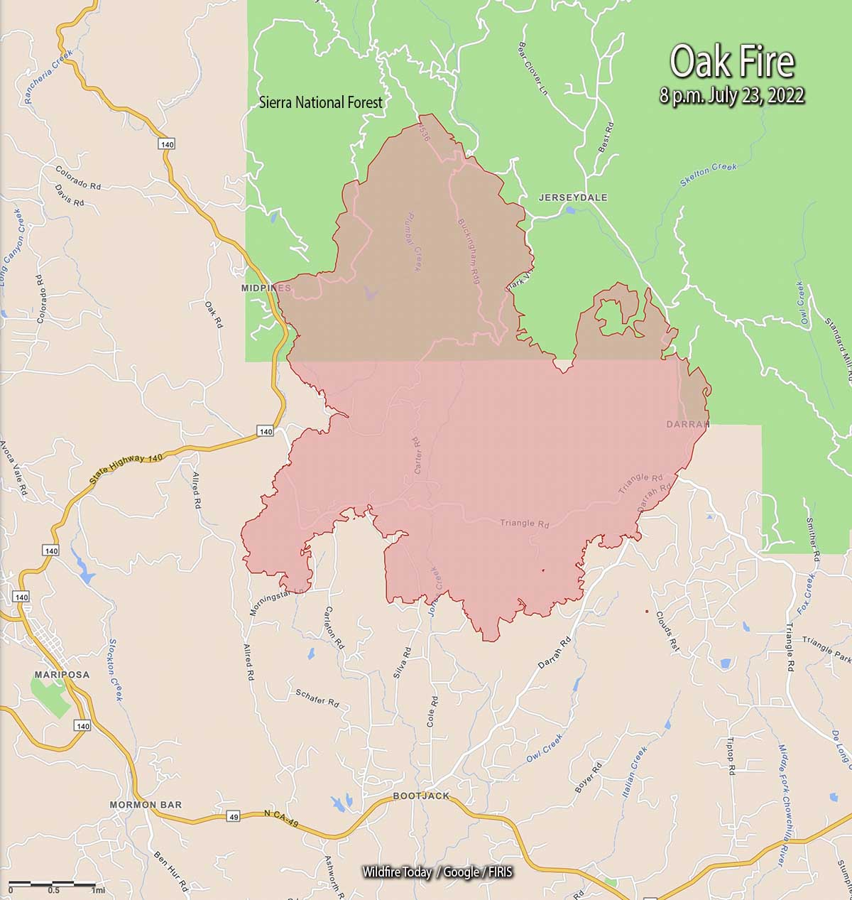
The Oak Fire has spread to the east quite significantly, crossing Jerseydale Road about two miles south of Jerseydale in the vicinity of Wild Dove Lane.
To see all articles on Wildfire Today about the Oak Fire, including the most recent, click HERE.
That puts it less than a mile west of the footprint of the very large Ferguson Fire which burned more than 96,000 acres in 2018. It was caused by a hot catalytic converter on a vehicle that parked in dry grass July 13, 2018 along Highway 140 near the Savage Trading Post.
The Oak Fire is exhibiting extreme fire behavior, igniting spot fires far ahead of the main fire.
CAL FIRE announced that at 6:45 p.m. it had burned 11,900 acres.
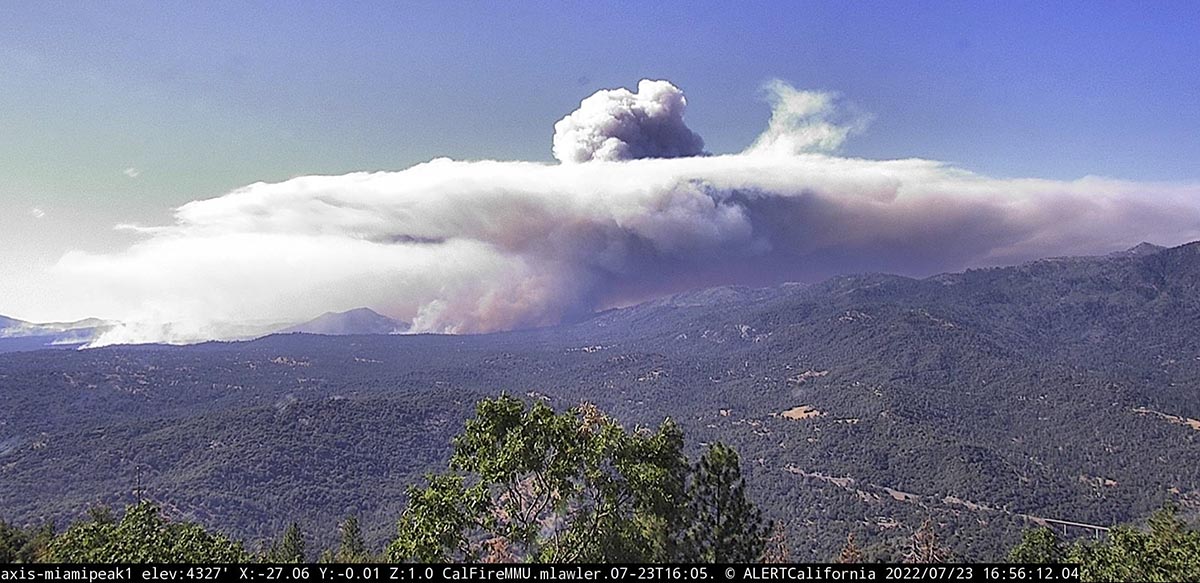
Oak Fire, as seen from Miami Peak, looking northwest at 7:43 p.m. July 23, 2022.
Updated 5:00 p.m. PDT july 23, 2022
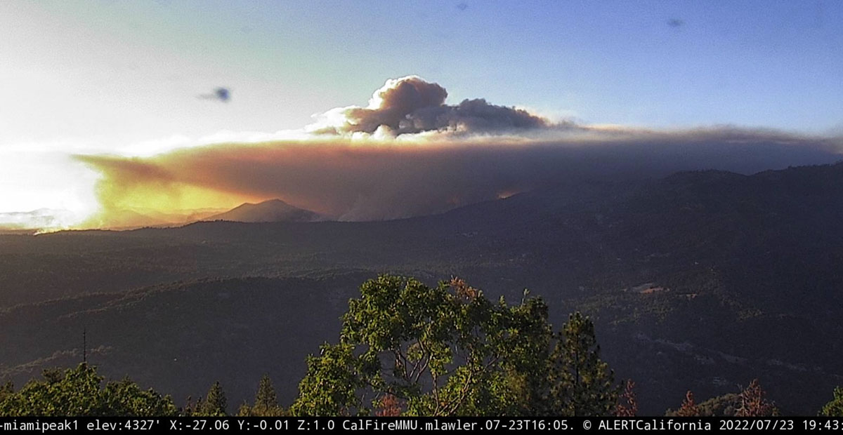
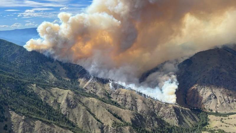
Oak Fire, looking northwest from Miami Peak at 4:57 p.m. July 23, 2022.
At approximately 4:20 p.m. Air Attack reported that the latest mapping of the Oak Fire showed had grown to 11,500 acres.
Updated 12:58 p.m. PDT July 23, 2022
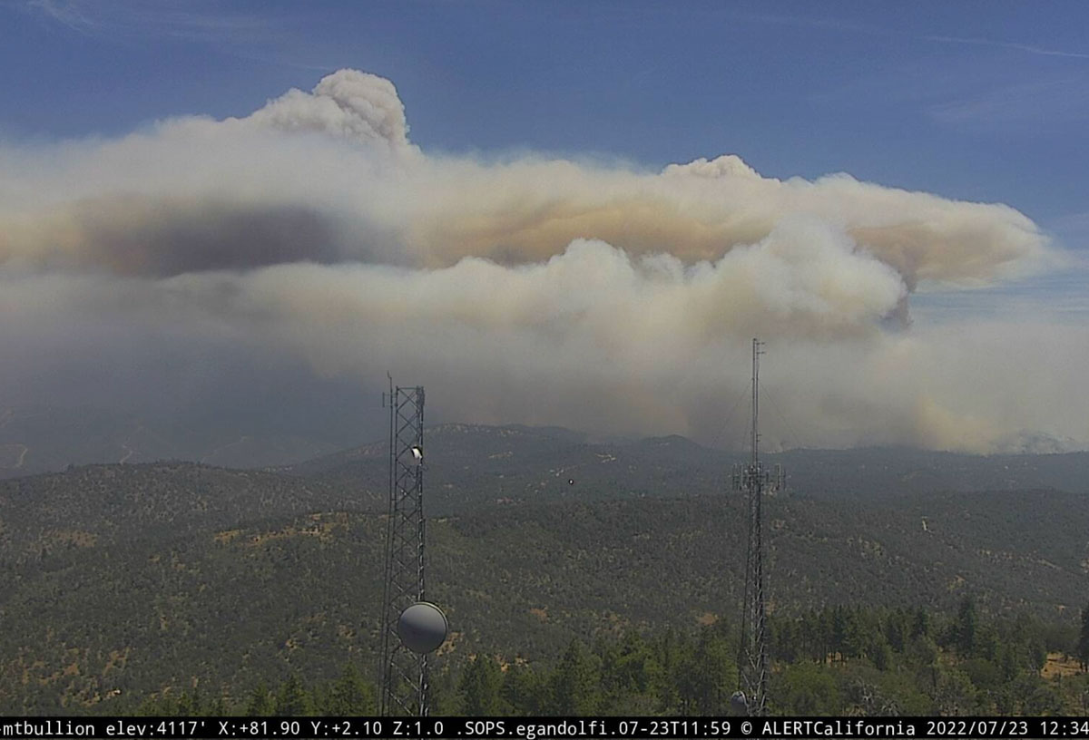
Oak Fire, looking east from Mt. Bullion, 12:34 p.m. July 23, 2022. AlertWildfire.
At 11:15 a.m. Saturday the Oak Fire was mapped by Air Attack at 9,100 acres.
CAL FIRE confirms 10 structures have been destroyed. That number will likely increase.
Updated at 8:35 a.m. PDT July 23, 2022
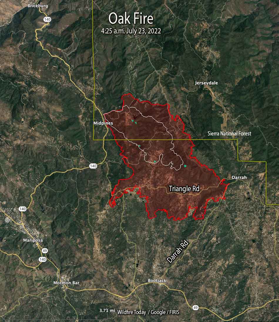
Oak Fire map, the red line was the perimeter at 4:25 a.m. July 23, 2022. The white line was the perimeter at 5:09 p.m. July 22.
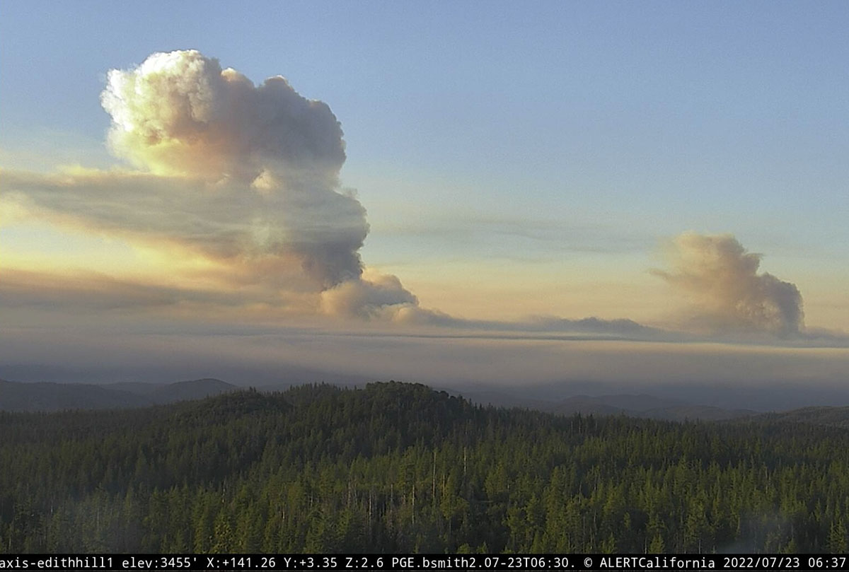
The Oak Fire at Midpines, California was active throughout much of Friday night, growing by about 2,200 acres between 10 p.m. and 4:25 a.m. Saturday when it was mapped by FIRIS at 6,555 acres. Half an hour after sunrise it was putting up two smoke columns that were quite some distance apart, with one of them creating enough energy to be capped by a pyrocumulus cloud.
Two smoke columns on the Oak Fire are seen soon after dawn, looking southeast from Edith Hill at 6:37 a.m. July 23, 2022.
Just to be clear — wildfires normally lay down at night, providing an opportunity for firefighters to move in closer and put in direct fireline. It is not common for a fire to be burning so actively soon after dawn that it is creating multiple smoke columns, especially a pyrocumulus column.
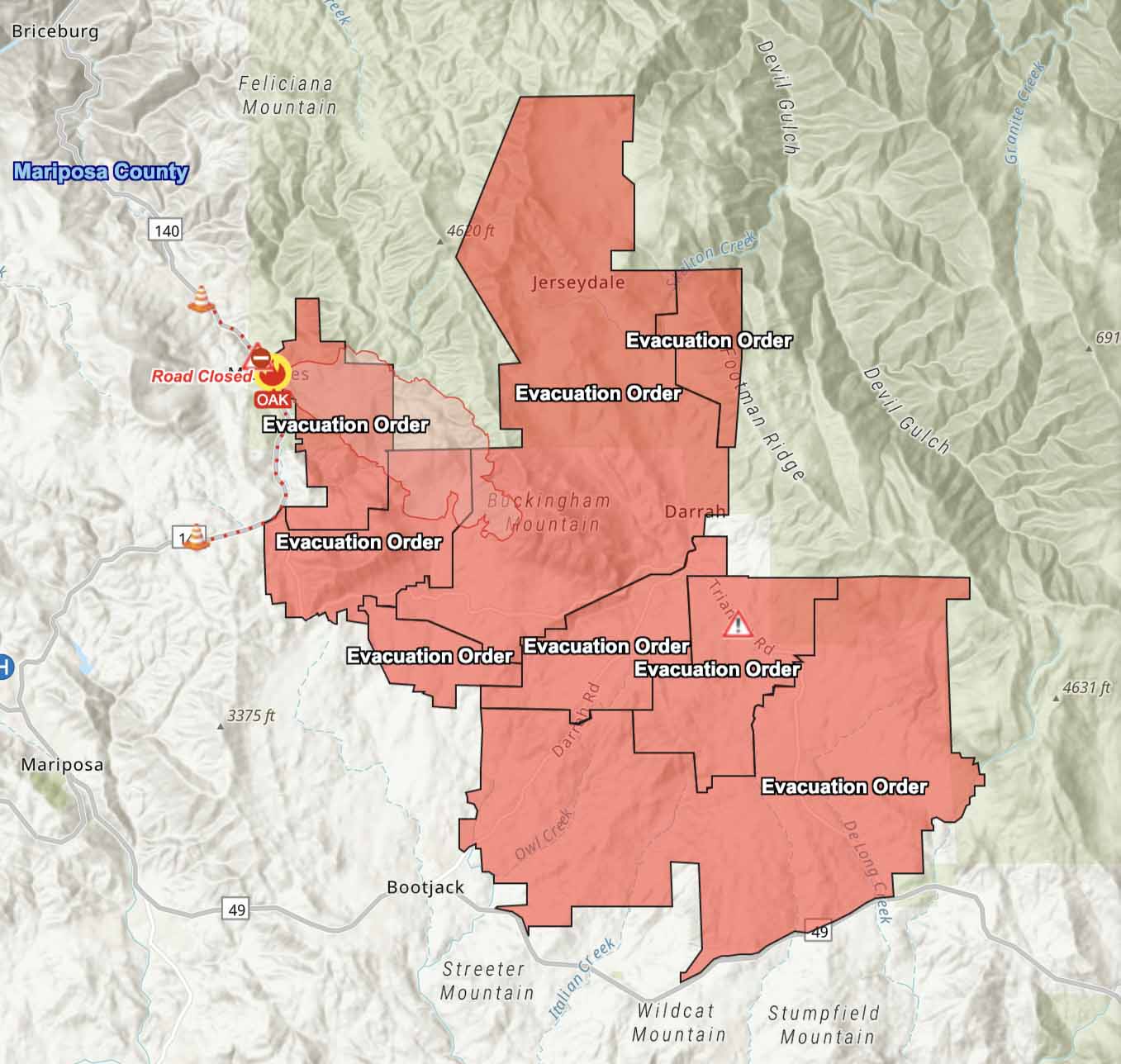
The Mariposa County Sheriff has ordered evacuations as far south as Highway 49 and east to Jerseydale. Their map is available online. As we wrote earlier, this is a dangerous fire.
The Oak Fire is spreading rapidly. When it was mapped at 4:25 a.m. Saturday it had spread south across Triangle Road and reached Darrah Road. At that time it was about a half mile west of the community of Darrah. Firefighters were planning a burning operation between Triangle Road and Darrah Road west of the town.
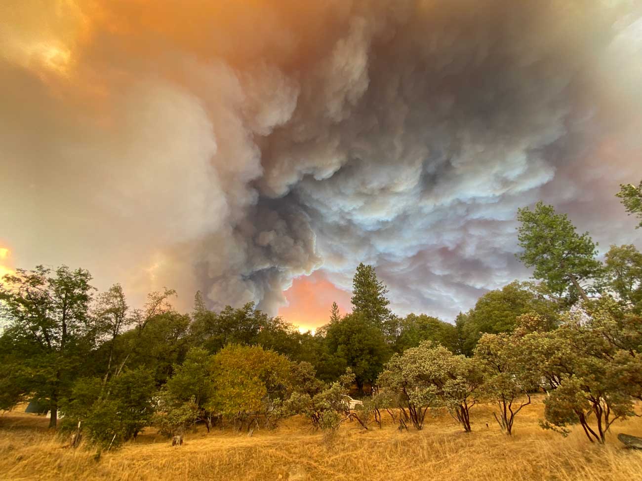
Oak Fire, Lush Meadows subdivision, Friday afternoon July 22, 2022. Credit: Chad Anderson.
Weather
The spot weather forecast for the area predicts hot and dry conditions to persist into next week. Winds will be generally light, except becoming gusty in the afternoons. On Saturday, mostly sunny skies, 90 to 94 degrees, 9 to 13 percent relative humidity, and 6 to 12 mph ridgetop winds from the south to southwest gusting to 20 mph in the afternoon. Saturday night will see poor humidity recovery, 26 to 31 percent, with very light winds. For Sunday, 10 to 14 percent RH with afternoon ridgetop winds out of the west at 4 to 8 mph.
10:36 p.m. PDT July 22, 2022
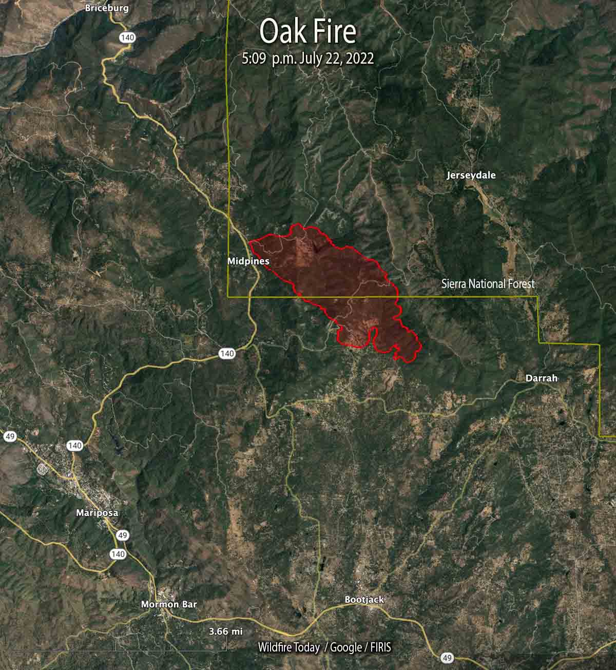
Oak Fire map at 5:09 p.m. July 22, 2022. The fire is growing rapidly and has doubled in size since this data was collected.
The Oak Fire that started Friday afternoon in Central California has been growing rapidly in Mariposa County. The County Sheriff has ordered evacuations for several areas east and southeast of Midpines. At 10 p.m. Friday it was about 4 miles northeast of Mariposa.
Evacuation Map, Oak Fire, posted by the Mariposa County Sheriff at 10:21 PDT July 22, 2022. This is a dynamic situation and the evacuation status and map may only be current only for a short while.
This is a dangerous fire. Residents should not hesitate to evacuate if there is any doubt about their safety.
At 5:09 p.m. it was mapped at 1,745 acres; at about 10 p.m. CAL FIRE reported it had grown to 4,350 acres.
Oak Fire, looking east at 8:08 p.m. July 22, 2022.
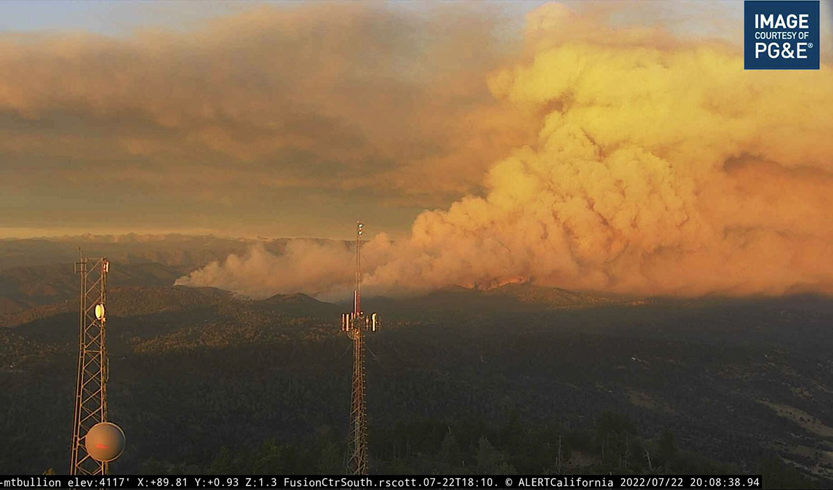
Staging area, Grant Fire, near the Salton Sea in Riverside County, California June 22, 2022. BLM photo.
This weekend we are continuing an occasional weekend feature we started a few weeks ago. This post can serve as the beginning of an open thread where our readers can talk about issues that we have, or have not, gotten into yet. This is literally an off-topic thread. You have the floor.
The usual rules about commenting apply. And remember, no personal attacks or politics, please.
Let’s enjoy a wide-ranging conversation!
(Oh, and send us pics of staging areas — date, location, and photographer’s name would be nice.)
Fire break under construction in Southwest France. July, 2022. France24.
The Bordeaux region in Southwest France has experienced many fires in the last few weeks that have burned a total of about 50,000 acres (20,000 Ha). Thinking that it will stop future fires, officials are building a large fire break three miles (5 K) long and about 1,000 feet (300 meters) wide.
Red areas on a map of Southwest France represent heat at wildfires detected by satellites during the seven-day period ending July 22, 2022. NASA FIRMS.
In parts of the Western United States back in the 1960s building fire breaks was a common practice. Some were only one or two dozer blades wide scraped down to mineral soil, while others were wider. But in later decades firefighters realized that no firebreak is likely to stop a rapidly spreading blaze.
Fires become large most often because they are burning in copious amounts of vegetation (fuel) during strong winds. Under unusually hot, dry, and windy conditions burning embers are lofted into the air. As they are blown downwind they can ignite new fires, “spot fires”, hundreds of feet or even up to a mile away from the main fire. Usually these embers are small, but can be as large as tree branches or even a four-by-eight-foot sheet of plywood, both of which have come close to or even hit air tankers working over the fire.
Under extreme conditions nothing will stop a large fire unless it completely runs out of fuel over a very large area, or the weather changes. A 1,000-foot fire break can stop a slow moving fire, but not a conflagration of the type that wipes out dozens of structures.
Something that cannot be ignored is that removal of all vegetation can result in severe environmental damage.
In the United States land managers are now more prone to build fuel breaks. They do not attempt to remove all vegetation, but only reduce it to the point where it will slow the spread of a fire enough that firefighters, sometimes aided by aircraft dropping water or fire retardant, can safely move in close to the flanks, make a direct attack, anchor the heel, and work their way along the edges and eventually stop the head of the fire. Fuel breaks helped firefighters last year on the Caldor Fire near South Lake Tahoe in California.
The first video below describes the firebreak in France. The next one is an update on the wildfires in the southwest part of the country.
More information is available about the helicopter crash in Idaho.
Both pilots have died, the U.S. Forest Service said on Friday.
Mary Cernicek with the Salmon-Challis National Forest said Thomas Hayes, 41, of Post Falls, Idaho, and Jared Bird, 36, of Anchorage, Alaska, died from injuries they sustained when their CH-47D Series Chinook crashed in the Salmon River about 3:30 p.m. Thursday.
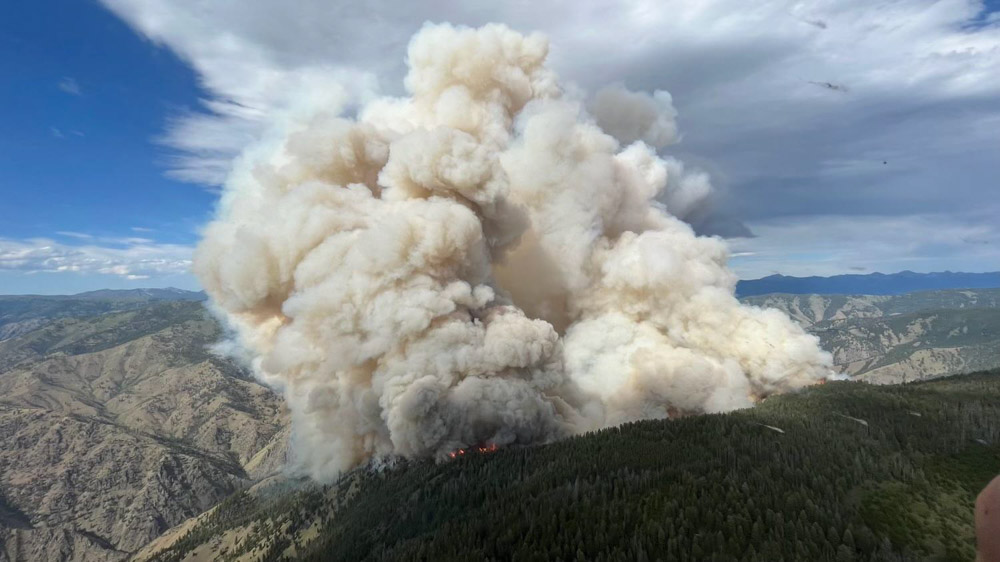
The pilots were employees of the Anchorage-based ROTAK Helicopter Services and were working on the Moose Fire northwest of Salmon, Idaho.
7:52 a.m. MDT July 22, 2022
CH-47D. ROTAK photo.
Thursday afternoon a CH-47D Chinook helicopter operated by ROTAK Helicopter Services crashed into the Salmon River while working on the Moose Fire northwest of Salmon, Idaho. The US Forest Service reported Friday morning there were two fatalities.
The company released a brief statement Thursday evening.
It is with heavy hearts that we confirm that on July 21, 2022, at approximately 3:30 p.m. a CH-47D series “Chinook” helicopter operated by ROTAK Helicopter Service with two pilots on board was involved in an accident near Salmon, Idaho. Emergency medical teams are responding to the scene. ROTAK is working closely with all appropriate agencies and will issue a full statement as information is confirmed.
We send out our sincere condolences to the families, friends, and co-workers of the two that were killed.
Growth of the fire
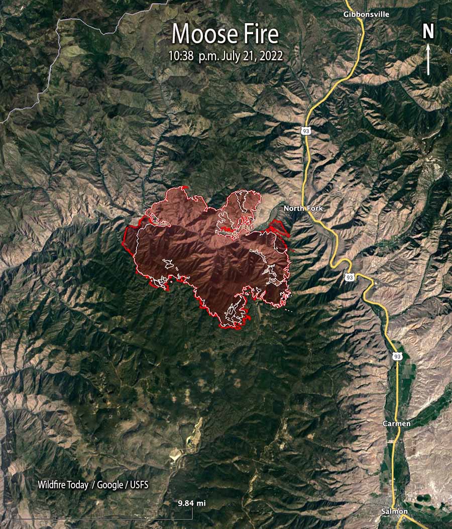
The Moose Fire grew incrementally on Friday, showing growth on all sides, primarily south of the Salmon River on the west and east sides. Very little growth occurred north of the river.
A mapping flight Thursday night determined it had burned 23,620 acres, an increase of nearly 3,000 acres. Much of that difference was due to an overnight change in procedure, a decision to not consider in the acreage the unburned islands in the interior. Previously the size of those islands had been subtracted from the total exterior perimeter.
Moose Fire map. The red line was the perimeter at 10:38 p.m. July 21, 2022. The white line was the perimeter about 24 hours previously.
Weather
The forecast for Friday afternoon is for increasing winds, gusting out of the west and then northwest at 31 mph with the relative humidity in the mid-teens. After sunset the wind will drop to about 6 mph out of the north. Saturday should bring 5 to 8 mph winds out of the south shifting to the north, with 13 percent relative humidity.
Firefighters expect the weather on Friday could lead to spread south of the Salmon River west towards Spring Creek, east towards North Fork, and spotting to the north side of the river.
Resources
Resources assigned to the fire Thursday evening included 18 hand crews, 25 fire engines, and 7 helicopters for a total of 517 personnel, a 24-hour increase of 141 individuals.
Structures
There are no reports of structures burning, but 301 are threatened. Evacuation information is available at the Lemhi County website.
Tunnel Fire north of Flagstaff, AZ, April 19, 2022, as seen from O’Leary Lookout in Northern Arizona. USFS photo.
This article first appeared in the Arizona Daily Sun. It is used here with their permission and the author’s.
Arizona Daily Sun Editor’s note: This is a bit unusual, to run a column on the front page, but I thought Mark’s perspective from his more than two decades working with Hotshots was a valuable read. He wrote this on a personal basis and not on behalf of any fire or forest management organization.
By Mark Adams
This has been a rough year for extreme fires in Flagstaff.
Before most of the U.S. Forest Service seasonal workforce was even finished with their mandatory two weeks of training, the Tunnel Fire started in one of the windiest areas of the San Francisco Peaks, during one of the windiest springs I can remember. In addition to that, it was located in the Schultz burn scar, which, at 12 years old, was primed for a fast-moving and difficult-to-contain fire due to the tall grass and kiln-dried logs that are easily receptive to any hot ember that decides to land on it. The Tunnel is what one seasoned “fire dog” referred to as a career fire — meaning that experiencing a fire like that happens once a career, if at all.
Amazingly, this fire was in mid-April, and sadly, many structures were lost, despite the huge, aggressive firefighting effort. The Tunnel Fire was unprecedented for the amount of damage caused in that short amount of time. In a typical year the Coconino averages around 175 fires, and nearly all of them are caught early and mostly go unnoticed by the average Flagstaffian. This summer we have had around 23 fires already and two of them have become career fires. Both escalated to become the No. 1 priority fires in the nation, the Tunnel and now the Pipeline Fire.
I moved to Flagstaff 28 years ago from the East Coast and like most other Flagstaff transplants, the Peaks drew me here and have been my sacred place. The Peaks are the heart and soul of Flagstaff; some might say they are the heart and soul of the state. When I moved here, I knew nothing about wildfires. The little I did know was from what I saw on the news about the Yellowstone fires of 1988. Like most people, I didn’t understand why fire managers were letting Yellowstone burn and not putting them out; I was mad that all those forests were burning. If the internet had been around, I would have been a loud critic of the Forest Service, just like so many people today commenting in online forums like they are experts in forest and fire management.
Fast forward many years later, after a long career as a Hotshot, I now better understand wildfire and the critical role it plays throughout our Western forests. All of the forests are flammable and will burn, eventually. The work we do and our efforts each year are done in hopes that they burn under our terms.
During my career, my crew and I have been emergency-shifted from one fire to another two times. The first time was on an afternoon in 2010 when I was a Mormon Lake Hotshot and we were on the Tecolote Fire in New Mexico. The radio sounded out from Incident Command: “Get Flagstaff and Mormon Lake hotshots off the mountain and come to ICP and demob immediately, there is a situation on the Peaks in Flagstaff.” In a matter of hours (which is lightning fast in federal government time), we were out of the Santa Fe Wilderness and on the road home to help fight the Schultz Fire. The next day we were briefing with fire managers at the Chevron station on Highway 89. We would be deployed behind the homes of Timberline and tasked with doing whatever we could to protect them.
History repeated itself this week. While on the Cerro Bandera Fire south of Grants, New Mexico, I received a text from Flag Dispatch of a new start. These texts come daily and normally I read them and say to myself, “Oh, they’ll catch that one” — because we do 98% of the time. This time was different. Upon checking the text, I immediately realized this one could be a problem — it’s windy and it’s in a bad spot. After making a few phone calls, once again my crew and I were quickly released and on the way back home to protect the mountain we and so many others love so much. We made it to the fire seven hours after it was first reported, lightning fast considering we started that day in a different time zone.
Pipeline Fire north of Flagstaff June 13, 2022, by @russdussel
Luckily that night we were able to help others piece together a plan and save many homes through quick action and, ironically, having the already burned ground of the Tunnel Fire helping us. Had that fire scar not been there, the Pipeline Fire would have destroyed many more homes than the Tunnel Fire had.
The next few days, grueling work was put in by my crew and many other crews from around the nation. I am forever grateful to the three Hotshot crews from California that were with us on the ridge below Fremont Peak. Ninety people hiked in and out every day, working some tough ground that spanned from 8,500 to 12,000 feet in elevation. The air was thin, the hazards were too numerous to count and if someone got hurt, medical extraction would be challenging. The alternative to this option was not good. Had we not been up to the work, the fire would have continued to the west and with the strong westerly winds gone, it would have torched the entire mountain. All of Flagstaff would have been buried under sandbags for the foreseeable future.
Flagstaff dodged another bullet. We got lucky — lucky the firefighting resources were available, lucky they recognized the situation, lucky we were willing to accept the risk of injury or worse. It’s coming. It’s only a matter of time. All of the Peaks, minus the rocks, are flammable and will burn someday.
End of story.
Recognizing and accepting this will only help to protect our Peaks. I say this because we have altered the natural cycle of fire for far too long. Now we have one of the most sacred places in the Southwest that is primed and more than ready for a catastrophic fire. Our challenge is to ensure that it doesn’t burn all at once and try to stay as close to the natural cycle as possible. And that natural cycle includes stand-replacing fires. We have a long way to go in protecting not only the Peaks but our forests in general, and it is time that we wake up and do what needs to be done. Everyone talks a good game, but we all can do more to ensure that we have healthy ecosystems to live in for generations to come.
There are ways that we, as a community, can limit the catastrophic results of the Big One:
1. Allow for day use only on the Peaks and Dry Lake Hills near Highway 89, 180 and across Forest Road 418.
2. Follow all campfire restrictions.
3. Educate the influx of out-of-towners moving here, often unaware of our wildfire-dependent and prone ecosystem.
4. Do everything in your abilities to prepare your home/property for wildfire. The 10 years you prepare before a fire are far more important than the 10 minutes or even hours before a fire — no matter how many engines, crews, airtankers and helicopters are available.
5. Support and obey any forest closures and don’t whine about it!
6. Get used to smoke! Support aggressive, forward-thinking fire management, including managing fires under the right conditions on the Peaks and across the forest.
7. Reward and support active fire and forest management, including prescribed burning, even if there is an occasional bad outcome (99.8% of all prescribed fires are successful).
8. Question managers that do not take risks, by choosing the safe route — putting all forest fires out small, never managing a fire for resource benefit and not conducting as many prescribed fires as possible. They are just kicking the can down the road.
The Peaks are going to burn again and I would much rather they burn when we say so. Not when a campfire or burning toilet paper decides to get one going in the wrong spot on the wrong day. The choice to manage a fire or light a torch for prescribed fire is not one that we take lightly, the responsibility is huge! Things sometimes go wrong despite the best intentions. But the alternative of doing nothing has only one outcome and it’s not good.
Remember, it’s not if, it’s when.
Mark Adams has been a Hotshot on the Coconino National Forest since 1999, working on all three crews: Blue Ridge, Mormon Lake and Flagstaff Hotshots. He is currently the superintendent of the Flagstaff Hotshots. He wrote this as a concerned resident of the Flagstaff area — not as a representative of the Forest Service or Coconino National Forest.
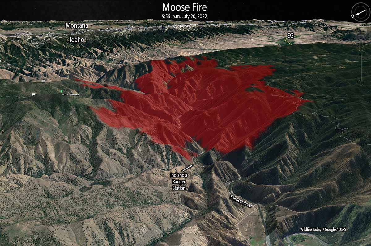
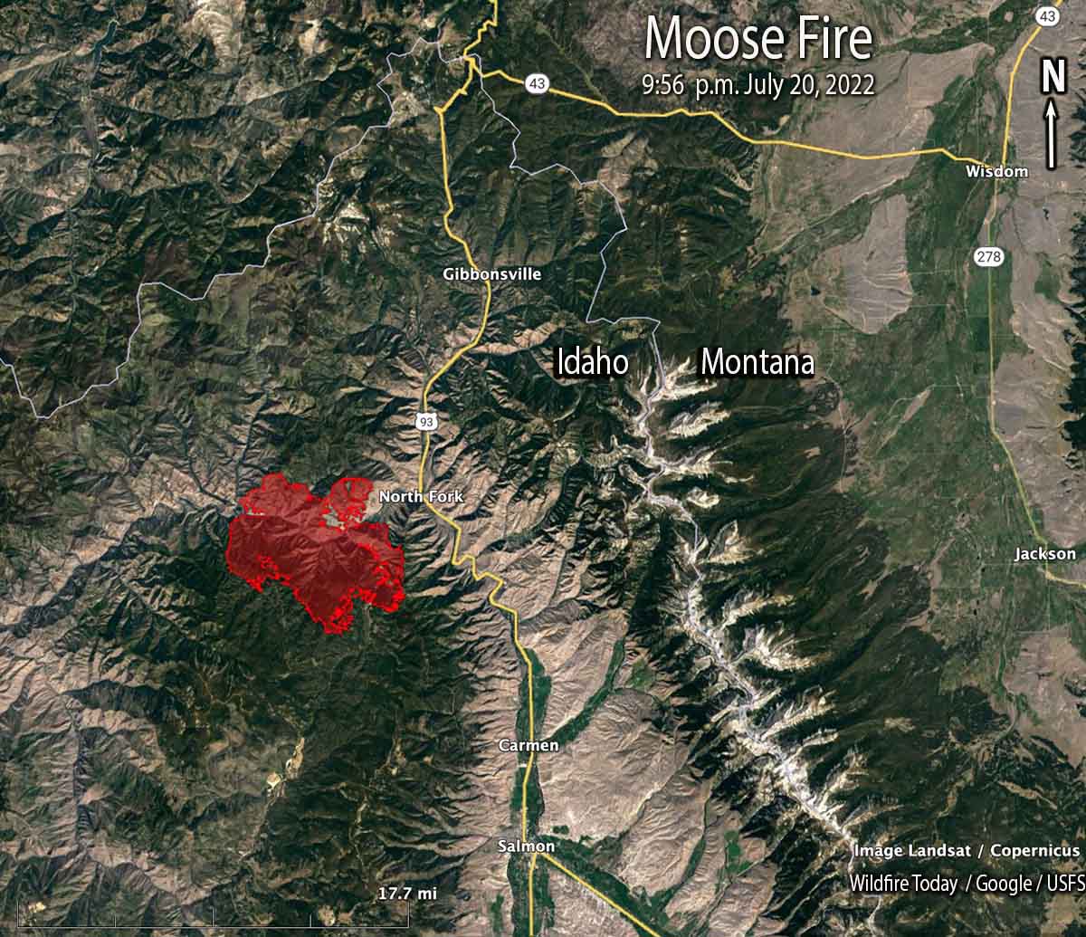
Moose Fire map, 3-D, looking east at 9:56 p.m. July 20, 2022.
The Moose Fire 12 air miles northwest of Salmon, Idaho was very active Wednesday afternoon on both sides of the Salmon River, on the west, south, and east flanks. A mapping flight Wednesday night found that it had grown to more than 20,600 acres and was 2 miles west of North Fork and Highway 93.
Fire officials said the potential remains for the fire to reach the Highway 93 corridor. Additionally, the fire continues to grow to the west along the south side of the Salmon River, beyond East Boulder Creek.
Moose Fire map, 9:56 p.m. July 20, 2022.
Fire crews are constructing direct and indirect fire line on the north side of the fire north of the Salmon River, working from Ulysses Mountain to the west and the east toward the river. On Wednesday burn out operations were completed near the mountain and crews secured and improved the line into the evening.
Moose Fire, July 17, 2022. InciWeb
South of the river firefighters are expecting to use indirect line, natural features, or roads to stop the spread.
Continued dry, hot, and windy conditions are expected Thursday with humidities near 10 percent and 15 mph winds out of the west gusting to 22 mph. The forecast for Friday predicts humidity in the mid-teens with stronger winds, 22 mph gusting to 31 out of the west switching to the northwest in the late afternoon. Fire growth on Thursday and Friday could be considerable, but conditions will moderate on Saturday and Sunday.
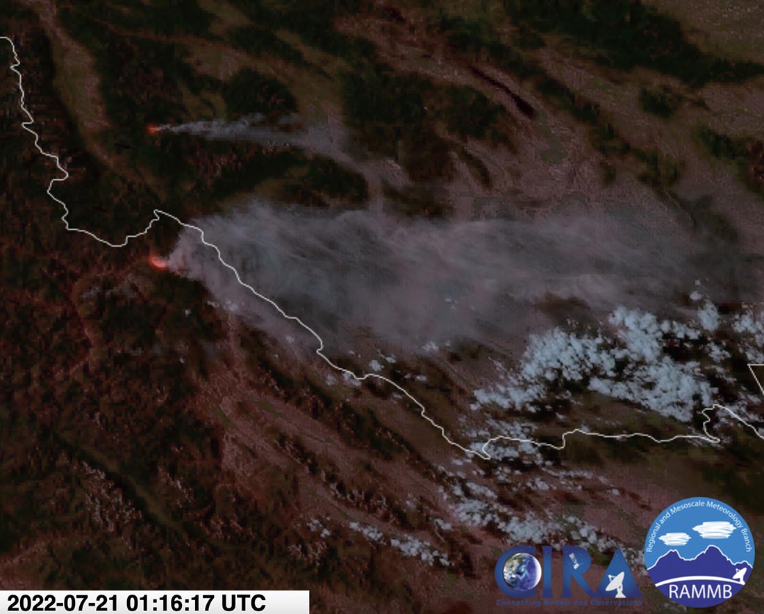
Another blaze, the Hog Trough Fire 53 air miles to the north-northeast, has burned about 350 acres 15 miles east-southeast of Grantsdale, Montana.
Moose and Hog Trough Fires, satellite photo at 7:16 p.m. MDT July 20, 2022. The Hog Trough Fire is the northernmost, and is smaller.
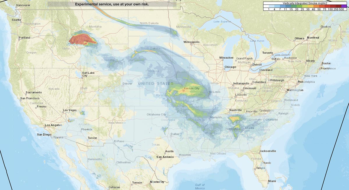
The forecast for smoke from the two fires predicts it will be moving primarily to the northeast and east Thursday afternoon and evening, possibly affecting Salmon, Butte, Bozeman, Livingston, Dillon, and points further east and southeast.
Smoke forecast for 8 p.m. MDT July 21, 2022. NOAA.
A Type 1 Incident Management Team has been activated. Other resources assigned include 18 hand crews, 25 fire engines, and 9 helicopters for a total of 517 personnel.