Firefighters conduct firing operation to protect town of High Level, Alberta

The #ChuckeggCreekFire has burned 92,000 hectares (227,000 acres) in northern Alberta

firing operation burnout protect High Level Alberta Chuckegg Fire
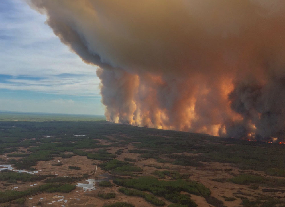
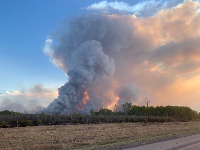
Smoke from a firing operation firefighters conducted on May 22 along Highways 58 and 35 to help protect the town of High Level, Alberta. Photo by Alberta Wildfire.

Firefighters battling the Chuckegg Creek Fire in Northern Alberta, Canada took advantage of a wind coming out of the northeast Wednesday to conduct a burnout or firing operation along Highways 58 and 35 to help protect the town of High Level. The goal is to eliminate fuel by burning to make it more difficult for the fire to make a run into the town if pushed by a southwest or west wind.

(To see all of the articles on Wildfire Today about the Chuckegg Creek Fire, including the most recent, click here.)

Below is more information from Alberta Wildfire:

  • Due to northeast winds and resources the fire has not reached the Town of High Level. The main area of spread remains away from town.
  • The High Level Fire Department and other municipal firefighters have completed structure protection on the southwest side of town and is being established on the northwest side of the town. In addition, structural protection has been established on Mackenzie County homes southeast of High Level, Tolko and Norbord.
  • Structural firefighters have also been taking preventive measures on homes. This includes removing debris from yards, removing patio furniture from decks and other flammable material.
  • [Wednesday] afternoon, firefighters conducted a successful controlled burn operation to create containment along highway 35 south of High Level, and west along highway 58. Further ignition operations will be utilized when conditions allow.
  • Alberta Wildfire firefighters along with air support from helicopters and air tankers continue to focus containment efforts south of High Level, and with current conditions firefighters continue to be effective, due to lighter winds out of the northeast. This in result continued to aided crews on protecting power line poles west and south of the Town of High Level.
  • The last recorded size is approximately 92,000 hectares. [227,000 acres]
  • Heavy equipment has been working along the northeast side of the fire and continue to make progress on consolidating a guard around the fire perimeter.
  • There are 110 structural firefighters that continue to establish and maintain structural protection on homes in the Town of High Level and on other critical values at risk within Mackenzie County. Alberta Wildfire has 76, firefighters along with 24 helicopters on this fire. There are more resources arriving daily.

The weather forecast for High Level, Canada predicts winds out of the northeast or north-northeast through Saturday, which should make it possible for firefighters to continue the burnout or construct firelines on the east and northeast sides of the fire. Sunday will bring warm temperatures and winds out of the southwest to southeast which could challenge the 76 wildland firefighters assigned to the blaze.
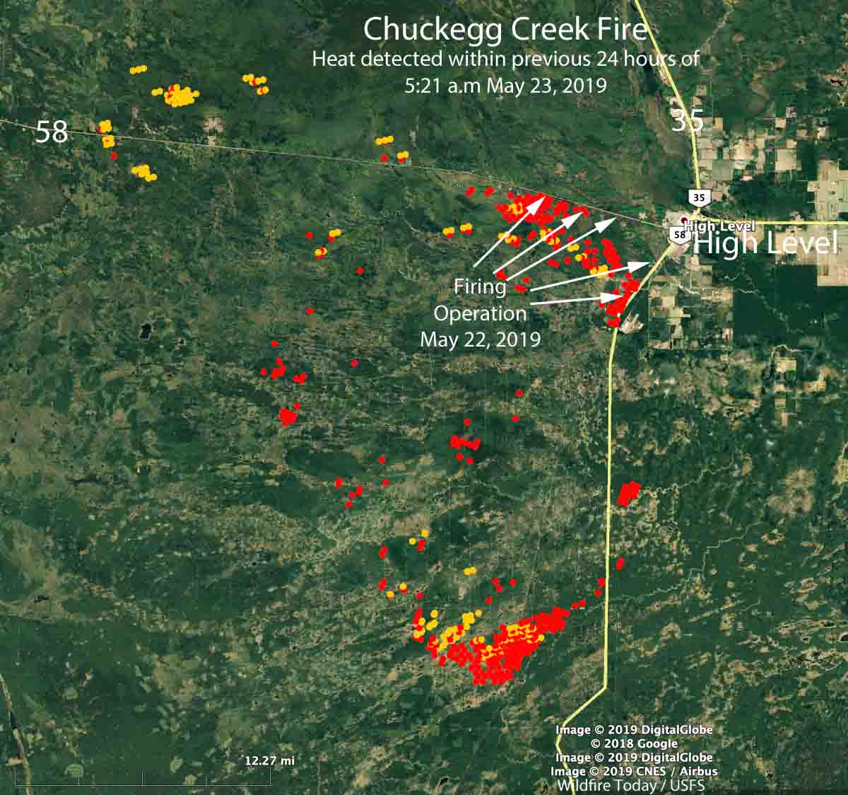
map High Level Alberta Chuckegg Fire
Map by Wildfire Today showing heat that was detected in the 24 hours previous to 5:21 a.m. MDT May 23, 2019. The arrows indicate where firefighters conducted a burnout or firing operation along Highways 58 and 35 to help protect the town of High Level, Alberta.

The town of High Level, Alberta is being evacuated

The entire community is under an evacuation order due to the approaching Chuckegg Creek Fire.

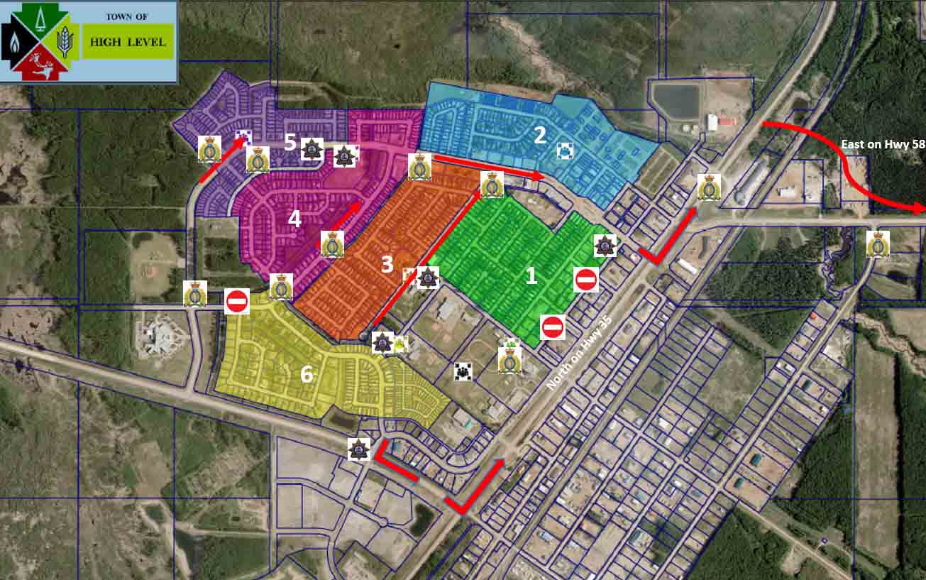
evacuation plan map High Level, Alberta
Map for the evacuation plan for the town of High Level, Alberta. Evacuations will be carried out by zones, within town limits.

The town is in the northern portion of Alberta and had a population of 3,159 in 2016.

(To see all of the articles on Wildfire Today about the Chuckegg Fire, including the most recent, click here.)

An area north of the town of High Level is under a voluntary evacuation notice.

Map Chuckegg Creek HWF042 wildfire
Map of the Chuckegg Creek HWF042 wildfire southwest of High Level, Alberta at 3:12 p.m. CDT May 20, 2019. Click to enlarge.

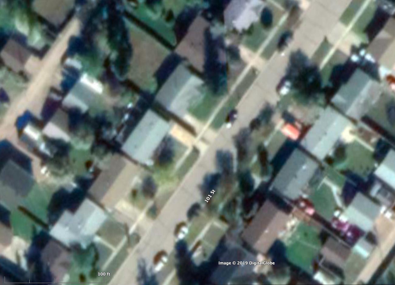
Some of the homes in High Level are very close together which will make it difficult for firefighters to defend the structures if the fire enters the community pushed by a strong wind.

Homes in community threatened by wildfire in Alberta are dangerously close together

In some areas the homes in High Level, Alberta are closer than the homes were in Paradise, California before the Camp Fire of November, 2018.

housing density High Level, Alberta Chuckegg Creek Fire
Satellite photo showing housing density in High Level, Alberta, which is threatened by the Chuckegg Creek fire. Note the graphic scale at bottom-left. The spacing between some of the homes is about 10 feet. Photo from Google Earth dated Sept. 19, 2019. Click to enlarge.

The entire town of High Level, Alberta is being evacuated today, May 20, 2019. If the Chuckegg Creek Fire burns close to or into the town while pushed by a strong wind, it could be a repeat of the nightmare scenario we saw last November in Paradise, California when the Camp Fire spread from house to house.

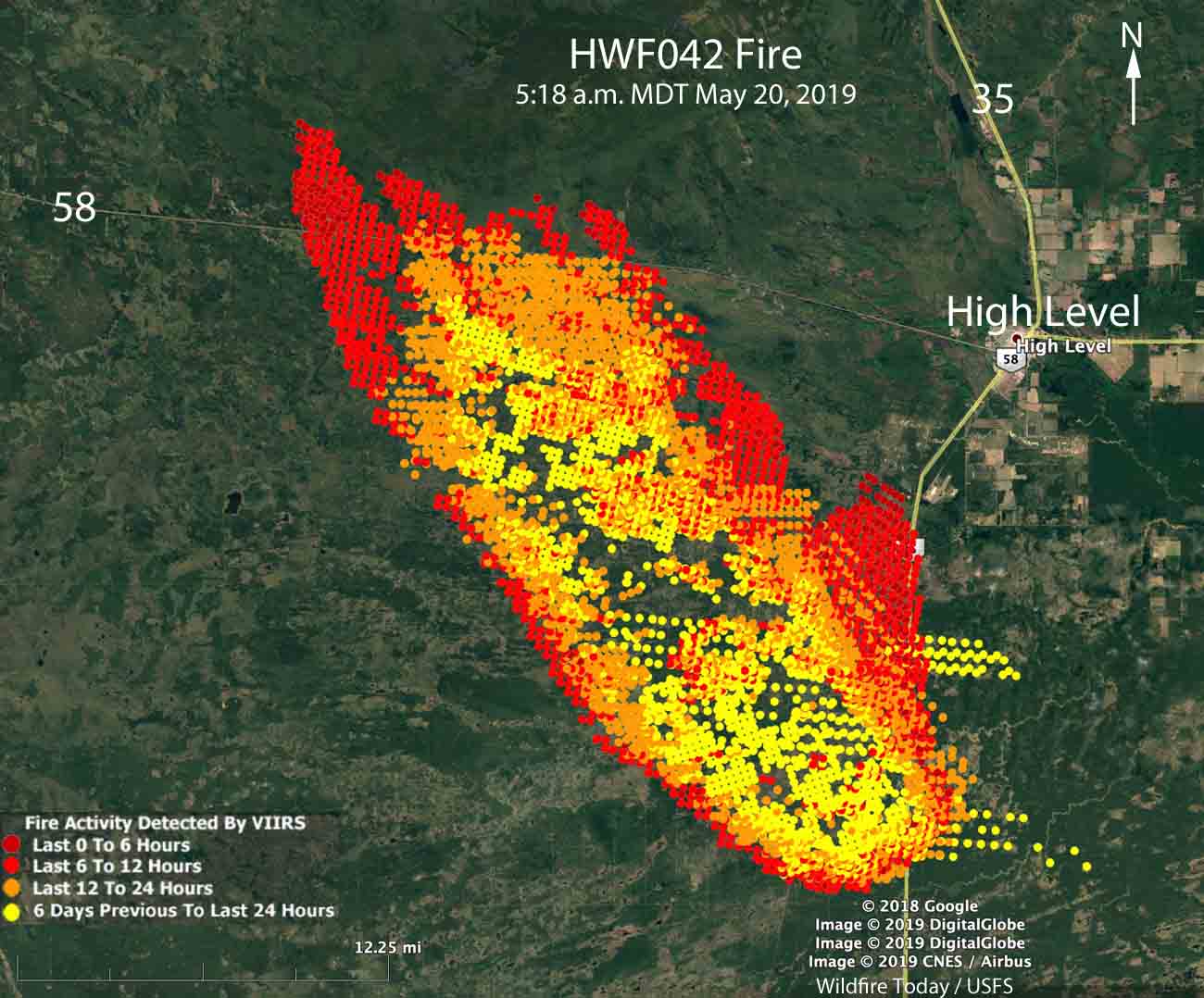
Map of the Chuckegg Creek HWF042 wildfire
Map of the Chuckegg Creek HWF042 wildfire southwest of High Level, Alberta at 5:18 a.m. CDT May 20, 2019.

Monday at 3:12 p.m. MDT the Chuckegg Fire was about four miles southwest of High Level. Moderate or strong winds are expected to push the head of the fire toward the northwest  this week, but spread on the flanks will most likely cause it to move closer to the town at the same time. By the weekend the forecast calls for winds out of the west that would seriously increase the threat to the town unless the 64 firefighters assigned on the 170,000-acre fire can perform heroic measures to stop the fire in that area.

(To see all of the articles on Wildfire Today about the Chuckegg Fire, including the most recent, click here.)

In some neighborhoods in Paradise last Fall the homes were about 18 to 20 feet apart according to the measurements we took using Google Earth. In High Level, that separation distance is about half that — in some areas the homes are about 10 feet apart.

When one structure is ignited by a burning ember that may have traveled a quarter of a mile or more from a fire (or a burning home) the radiant heat alone can ignite the homes on both sides. Then you can have a self-powered conflagration spreading house to house through a city. When the structures are that close together, the homeowners have not reduced the fuel in the Home Ignition Zone, and the home itself is not built to FireWise standards, a massive disaster can be the result. A strong wind exacerbates the problem. In Paradise the wind kept much of the heat and the embers close to the ground, preheating fuels ahead. The canopies of some of the trees survived, but virtually nothing near the ground remained unburned.

Wildfire in Alberta burns more than 100,000 acres

The fire is seven miles southwest of High Level, AB

Map of the Chuckegg Creek HWF042 wildfire
Map of the Chuckegg Creek HWF042 wildfire southwest of High Level, Alberta at 5:18 a.m. CDT May 20, 2019. Click to enlarge.

(UPDATE at 2:39 p.m. MDT May 20, 2019)

Mandatory evacuation order issued for an area near High Level, Alberta, due to the Chuckegg Creek Fire. At 11:40 a.m. May 20 Mackenzie County declared a State of Local Emergency and issued the order for residents living south and southeast of the Town of High Level, Alberta. All evacuees must register at the High Level Arena (10101 105 Ave). Crews will be going door to door to notify affected residents. Manned barricades will be set up on all roads to prevent unauthorized entry into the evacuated areas.

(To see all of the articles on Wildfire Today about the Chuckegg Fire, including the most recent, click here.)


(UPDATED at 11:31 a.m. MDT May 20, 2019)

The Chuckegg Creek Fire southwest of High Level, Alberta continued to spread rapidly to the north Sunday afternoon and into the night, running across and becoming well established north of Highway 58.

The Town of High Creek advised their residents Monday morning:

As of 9:00 a.m. May 20, 2019, the town remains in no immediate danger, but residents are recommended to remain vigilant and be prepared to evacuate if conditions change. The eastern flank of the fire had slow growth over night. The HLFD will begin Sprinkler protection operations today May 20, 2019, in town and at the Tolko mill.

Our very unofficial estimate of the size, based on satellite imagery at 5:18 a.m. May 20, is that the Chuckegg Creek Fire has burned approximately 150,000 acres (60,700 ha). (UPDATE at 11:26 a.m. MDT May 20: Alberta Wildfire said the fire has burned 69,000 ha (170,500 acres).

Strong gusty winds are in the forecast again for Monday, which should produce continued growth of the fire.

Alberta Wildfire has 64 firefighters, heavy equipment, and helicopters and air tankers working to contain the fire. Additional resources have been requested.


(Originally published at 3:44 p.m. MDT May 19, 2019)

Chuckegg Creek Fire Alberta High Level
Chuckegg Creek Fire southwest of High Level, Alberta. Photo by Alberta Wildfire (around noon May 19, 2019).

A very large wildfire in northern Alberta almost doubled in size Sunday due to low humidity and 20 km/h southeast winds gusting to 40. The strong winds are expected to continue until dark Sunday but will become lighter Sunday night through Tuesday.

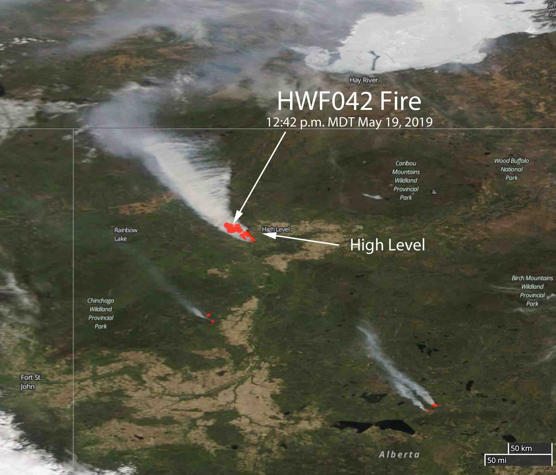
The fire is approximately seven miles southeast of High Level and is spreading toward the northwest.

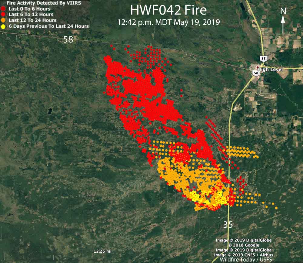
The most of the fire is west of Highway 35 and south of Highway 35, but there is active fire east of 35. On Sunday it crossed Highway 58, 17 miles west of High Level.

Satellite photo wildfire High Level, Alberta
Satellite photo of the wildfire southwest of High Level, Alberta at 12:14 p.m. CDT May 19, 2019.

Officials said Sunday that neither the Town of High Level or Norbord Plant are under immediate threat. There was no Evacuation Alert in effect Sunday at noon, but residents were advised to remain vigilant.

map wildfire high level alberta may 19, 2019
Map of the wildfire southwest of High Level, Alberta at 12:14 p.m. CDT May 19, 2019.

On Sunday morning May 19 Alberta Wildfire reported the fire, named Chuckegg Creek HWF042, was 25,334 ha (62,600 acres). Our very unofficial estimate of the size when it was overflown by a satellite at 12:14 p.m. MDT May 19 is 40,000 ha  (99,000 acres). This measurement was based on heat detected by the satellite. Generally a fire can be described as a “megafire” when it reaches 100,000 acres.

The fire is being fought with heavy equipment and 53 firefighters, along with air support from helicopters and air tankers.

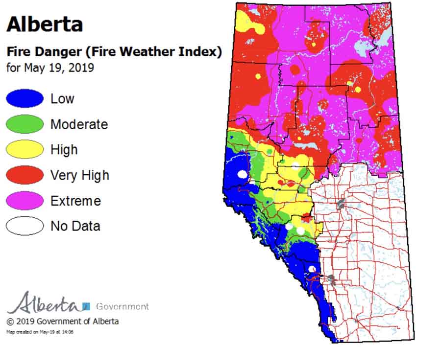
Wildfire danger in Alberta, May 19, 2019
Wildfire danger in Alberta, May 19, 2019. By Alberta Wildfire.

Official report shows Fort McMurray Fire created lightning-started fires 26 miles away

Officially named the Horse River Fire, it burned 589,552 hectares (1.4 million acres) in 2016, destroyed 2,400 structures, and forced 80,000 to evacuate.

Above: These two fires started at about the same time on May 1, 2016 near Fort McMurray, Alberta, Canada. Seen just after they started, on the left is the MMD-004 fire inside the city limits of Fort McMurray. The Horse River Fire, often referred to as the Fort McMurray Fire, is on the right. Alberta Forestry photo.

(Originally published at 4:04 p.m MST November 2,1 2017)

As the wildfire season slows in the western United States and Canada we have had a chance to look back on some of the more significant blazes. One of the largest in recent years, if not THE largest, was in 2016 in Alberta, Canada, the 589,552-hectare (1.4 million-acre) Horse River Fire that generally became known as the Fort McMurray Fire. It burst into the headlines when it burned into Fort McMurray destroying 2,400 structures and forcing 80,000 residents to evacuate for about a month.

No one was killed directly by the fire, but two young people died during the evacuation when their SUV collided head-on with a logging truck. One of them was a firefighter’s daughter, 15-year old Emily Ryan, one of three triplets. The other was Aaron Hodgson, her stepmother’s nephew.

Firefighters talk about “extreme fire behavior”, but this fire took it to a different level. For example, according to the report released in June, on May 4 high spread rates and downwind spotting drove the fire 40-45 kilometres (26-28 miles) to the southeast by the next morning. Convection column heights on the afternoon of May 4 reached 12.5 kilometres (41,000 feet or 7.8 miles) and lightning from the pyrocumulonimbus cloud atop the column started a number of new wildfires 40 kilometres (26 miles) ahead of the main wildfire front.

Yes, lightning from the smoke column and clouds created by it started multiple new fires 26 miles downwind.

As climate change extends the length of wildfire seasons, Alberta is no exception. Since 1994 50 percent of the wildfire acres (or hectares) burned in the province have occurred in May. And right on schedule, two fires started at about the same time on May 1, 2016, one within the city limits of Fort McMurray and another west of the city.

They were both detected by a “loaded patrol”, which is a helicopter with firefighters whose mission was to find new fires soon after they started and attack them quickly. The first air tanker group, two air tankers with a bird dog (lead plane), was on scene within 30 minutes. It would have been quicker but the nearest air tanker base, at Fort McMurray, was not staffed with tankers that day.

Below is an excerpt from the report where it discusses decisions made in the first few hours after the fire was detected by the firefighters patrolling in the helicopter.


“Complicating the situation was another wildfire that was reported almost simultaneously with the Horse River wildfire. This wildfire (known as wildfire MMD-004) was located immediately inside the boundary of Fort McMurray, and was in similar forest and weather conditions as the Horse River wildfire. Both wildfires received ground wildland firefighting crews. When air tankers arrived, AF [Alberta Forestry] officials were forced to choose between the Horse River wildfire and MMD-004 for initial air attack. [The photo above shows] both the Horse River wildfire and wildfire MMD-004 on May 1, at 18:35h.

“At the time, wildfire MMD-004 was in closer proximity to structures in the community than the Horse River wildfire and thus posed the greater immediate risk. It was also evident to the first air attack officer that applying air attack on wildfire MMD-004 was more likely to yield a successful result (a decision balancing risk and probability of success). With the exhibited fire behaviour and the time that had passed for the wildfire to gain some momentum, the Horse River wildfire was likely to outpace the actions of the dispatched air tanker groups. Crews on the ground could begin to fight the Horse River wildfire near the origin, but neither ground or air attack would be successful directly on the head of the wildfire. In the end, this judgement proved correct, and wildfire MMD-004 was successfully suppressed without damage to the surrounding values. The consequence was a further delay in the use of air attack to slow or redirect the Horse River wildfire.

“Within the first hour of commencing suppression activities on the Horse River wildfire, it became clear that initial attack efforts would not be successful in containing the wildfire. This awareness required another transition in the thinking of AF and RMWB [Regional Municipality of Wood Buffalo]. Operational personnel would continue to attack the wildfire, but the plan needed to shift to the requirement for expanded operations.”

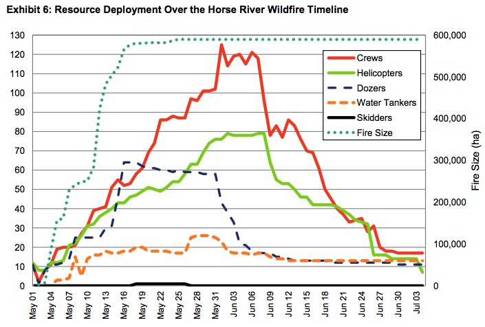
Horse River Fire resources assigned
A graphic from the report showing the growth of the Horse River Fire and the resources assigned.

Alberta firefighter killed in water tender crash

James Hargrave
James Hargrave. Photo from the office of Agriculture Minister Oneil Carlier.

A volunteer firefighter from southeast Alberta was killed in a vehicle accident Tuesday night October 17.

James Hargrave, a 34-year old firefighter with Cypress County Fire Services was working on a wildfire that started in Alberta and spread into Saskatchewan where it was moving toward the towns of Leader and Burstall.

Mr. Hargrave was driving a water tender that collided with a pickup. The Royal Canadian Mounted Police said he died at the scene. The driver of the pickup had minor injuries.

“James was very community-minded and joined the fire services to help and protect residents far and near. He was a great father and will be dearly missed by his wife, children, extended family, friends, neighbours and fellow first responders,” Cypress County said in a news release. “He was a great father and will be dearly missed by his wife, children, extended family, friends neighbours and fellow first responders.”

Our sincere condolences go out to Mr. Hargrave’s family, coworkers, and friends.

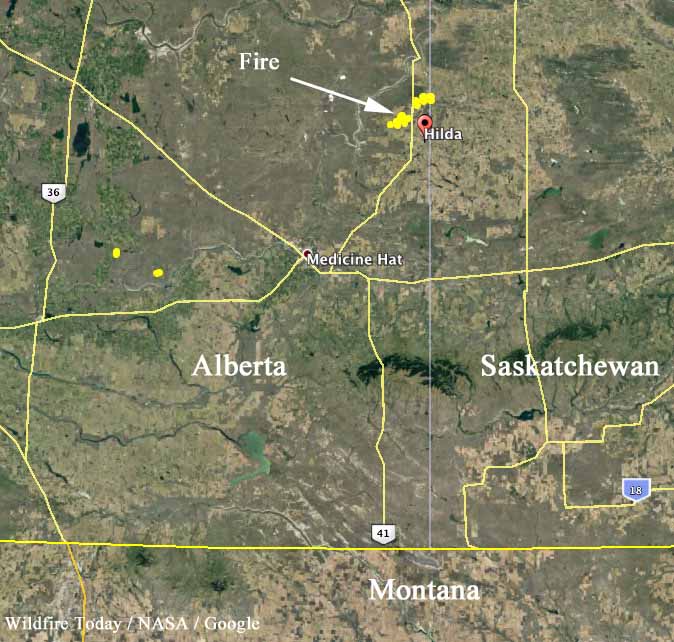
map fires alberta
Map showing fires detected in southeast Alberta by a satellite at 2:55 p.m. MDT October 17, 2017.