Southern California lightning

(Originally published at 1:33 p.m. MDT September 11, 2017)

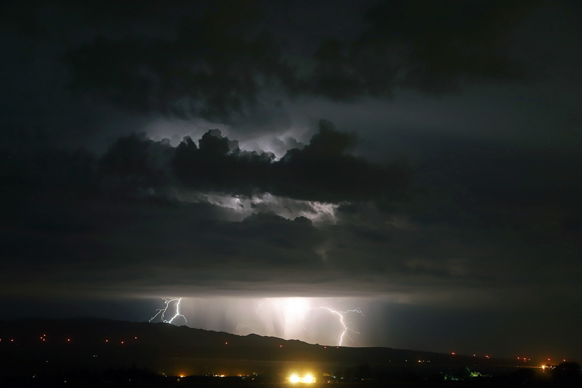
Jeff Zimmerman took these photos September 10 and sent them to us today. Here is how he described the event.

From the deserts to the sea, a wonderful display of lightning. Off the coast near Avalon where hundreds of strikes were recorded with numerous strikes all the way to Tehachapi Mountains. Tejon Ranch and Highway 58 area was bathed in lightning too. A new fire was reported on the Los Padres National Forest, lightning strike near Chuchapate (Sawmill). Possibly a few more isolated storms today, followed by gusty NW winds later this week. The first Santa Ana may set up when snow comes to Montana and offshore flow begins later this week bringing critical fire weather with it. Attached are a few shots from the desert in Neenach, CA (map).

lightning Jeff Zimmerman

lightning Jeff Zimmerman

Thanks Jeff!

Wildfires persist in the Cascades and Northern Rockies

Today there are 71 large uncontained wildfires in the United States.

Above: the red and orange dots on the map represent heat on wildfires detected by a satellite in the 24 hours before 7:30 a.m. MDT September 11, 2017. Heat found before that is not shown.

(Originally published at 7:45 a.m. MDT September 11, 2017)

In spite of the hurricanes impacting the southeast United States, the wildfires in the Cascade Range and the Northern Rockies persevere in Montana, Idaho, Oregon, Washington, and Northern California.

Off and on over the last week they have slowed as clouds and even some scattered very light showers passed over the areas, but the National Interagency Fire Center reported today there are 71 active large fires, 32 that are being suppressed and 39 that are being suppressed only where needed to protect property.

So far this year 8.2 million acres have burned in the United States, which is 46 percent higher than the 5.6 million average to this date.

Red Flag Warning Northwest Montana
Red Flag Warning for Northwest Montana, September 11, 2017. There is a Fire Weather Watch due to “abundant lightning on dry fuels” predicted Tuesday afternoon for areas in northern California and south-central Oregon.

The weather for Monday and Tuesday could be conducive to fire growth, especially in Northwest Montana where a Red Flag Warning is in effect Monday. But Wednesday through Saturday will bring a chance of rain to Idaho and Western Montana, while the forecast for Northern California, Oregon, and Washington looks dry this week.

Weather forecast Wednesday September 13
Weather forecast for Wednesday September 13, 2017. Weather.com

Satellite detects heat from wildfires, September 7

(Originally published at 6:36 p.m. MDT September 7, 2017.)

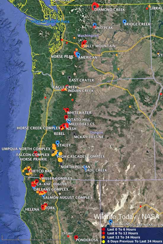
Large wildfires Washington Oregon northern California
Large wildfires currently active in Washington, Oregon, and northern California. The red, yellow, and orange dots represent heat detected by a satellite in the 24 hour period ending at 10 a.m. MDT September 6.

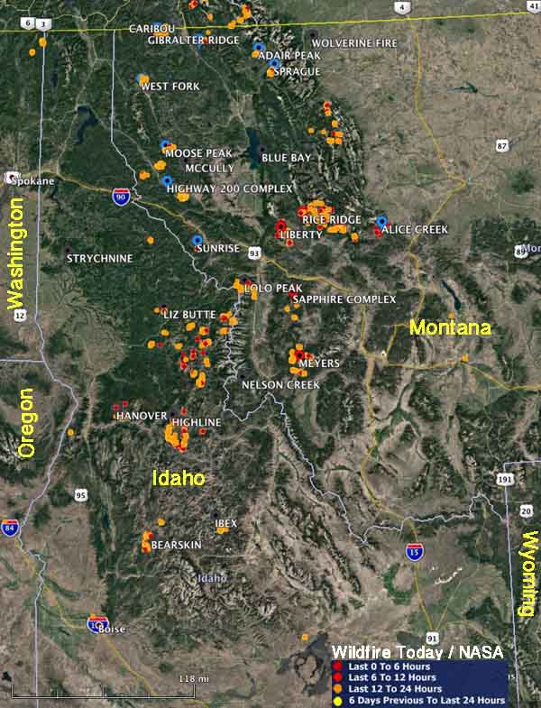
These maps show heat that was detected by a satellite on wildfires in the northwestern United States during the 24-hour period ending at 6 p.m. Thursday September 7, 2017. We did not include heat from the 6 days previous to the last 24 hours.

If there was heat found, it means the fires are still active, however some of it could be from proactive burning by firefighters to secure the area between firelines and the edge of the fires.

map wildfires idaho montana
Large wildfires currently active in Montana and Idaho. The red, yellow, and orange dots represent heat detected by a satellite in the 24 hour period ending at 6 p.m. MDT September 7.

Maps of wildfires in the Northwest U.S.

More than 27,000 firefighters are deployed on wildfires in the United States.

(Originally published at 10:35 a.m. MDT September 6, 2107)

Large wildfires Washington Oregon northern California
Large wildfires currently active in Washington, Oregon, and Northern California. The red, yellow, and orange dots represent heat detected by a satellite in the 24 hour period ending at 10 a.m. MDT September 6.

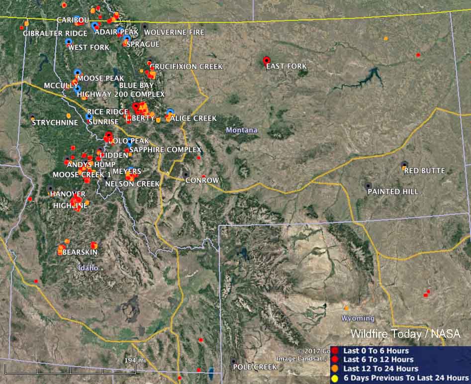
These maps show the locations of large wildfires that are currently active in the Northwest United States. The red, yellow, and orange dots represent heat detected by a satellite in the 24 hour period ending at 10 a.m. MDT September 6.

large wildfires map idaho montana
Large wildfires currently active in Idaho and Montana. The red, yellow, and orange dots represent heat detected by a satellite in the 24 hour period ending at 10 a.m. MDT September 6.

According to the National Interagency Coordination Center, today there are 50 large uncontained wildfires in the United States that are being aggressively suppressed. In addition, there are another 35 fires that are not being fully suppressed.

Very large numbers of firefighting resources are currently assigned across the United States, including 560 hand crews, 1,865 engines, and 222 helicopters, for a total of 27,256 personnel.

As of yesterday 7.9 million acres has burned this year nationally, which compares to the 10-year average of 5.4 million acres for this date.

The video below shows heat and smoke in Idaho and Montana detected by a satellite on September 3 and 4, 2017.

Photo of the 747 Supertanker dropping on the Palmer Fire

(Originally published at 7:22 a.m. MDT September 5, 2017 on FireAviation.com)

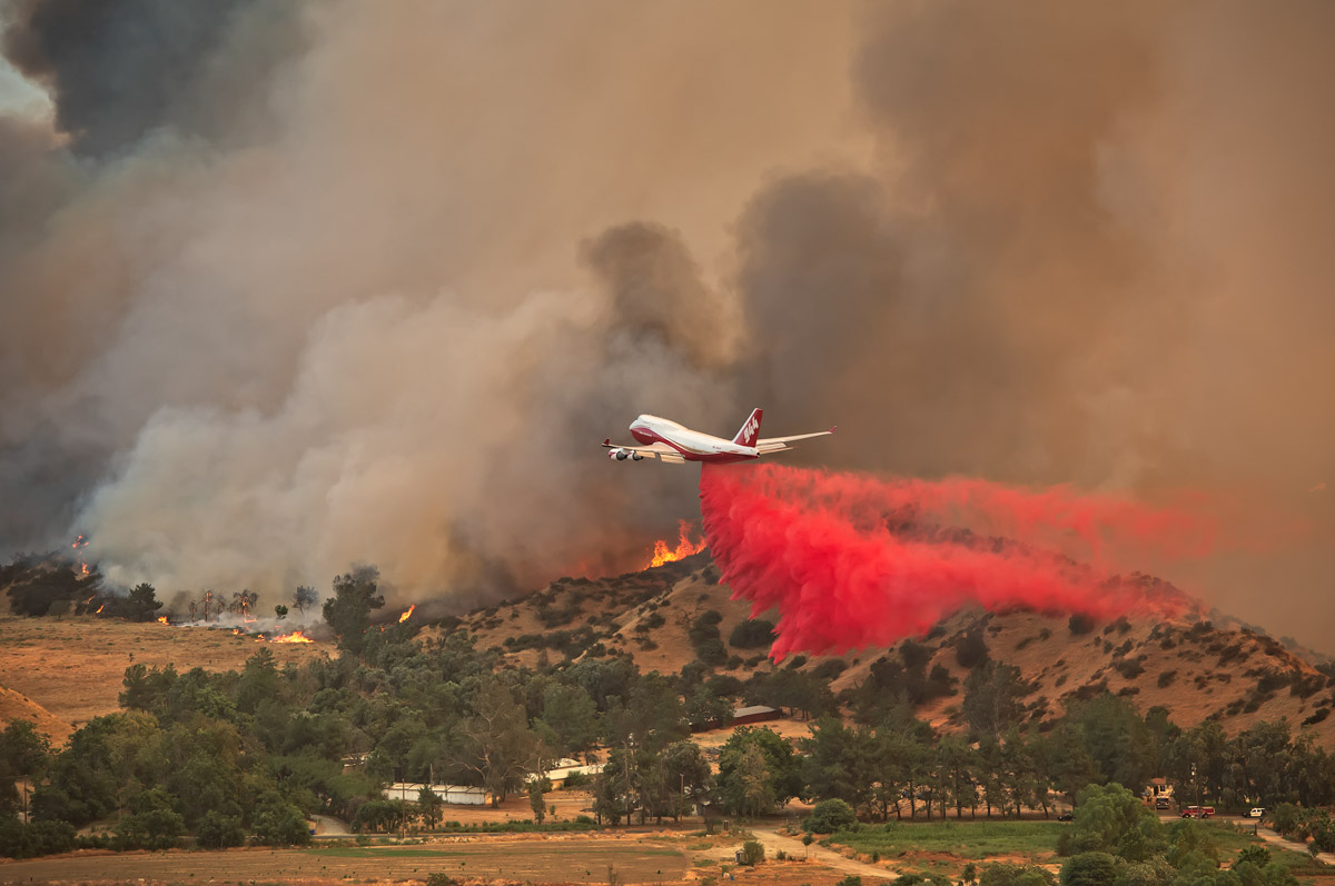
A few days ago Cy Phenice sent us an excellent photo of Air Tanker 944, the 747 SuperTanker, dropping on the Palmer Fire south of Yucaipa, California which we published September 3. Now we have another great photo of the huge airplane dropping on the fire.

It was taken by Leroy Leggit with a Nikon D810. He shot it at 1/800, F 5.6, using a 70-200mm lens at 150mm.

He said he took the photo from the top of a hill looking down at the aircraft.

747 Palmer Fire
Air Tanker 944, a 747-400, drops near structures on the Palmer Fire south of Yucaipa, California at 4:25 p.m. PDT September 2, 2017. Photo by Leroy Leggitt, used with permission.

He told us:

I didn’t know anything about the 747 supertanker until it appeared to my right (at eye level) headed straight toward the fire… what an amazing and unexpected sight… I looked online and saw that it had only been in service for a few days.

The Palmer Fire was reported at 1:33 p.m. MDT September 2, 2017. It is nearly officially contained according to CAL FIRE after burning 3,874 acres.

This was the second fire the aircraft was used on after receiving certification and a contract from CAL FIRE. The 747 was dispatched from McClellan Air Field near Sacramento. According to FlightAware it cruised south at over 600 mph at times before dropping on the fire about an hour later, then reloaded at McClellan and completed a second sortie, dropping almost 19,000 gallons again, splitting the load into two drops.

La Tuna wildfire burns structures, closes 210 Freeway in Los Angeles

Above: Map showing heat detected on the La Tuna Fire by a satellite. The red dots, the most recent, were detected at 2:42 a.m. PDT September 3, 2017.

(Originally published at 7:25 a.m. PDT September 3, 2017)

The Mayor of Los Angeles declared a local emergency as the La Tuna Fire forced hundreds to evacuate in Glendale and Los Angeles. Believed to be one of the largest in Los Angeles history, it had burned approximately 5,500 acres as of Saturday evening. Approximately three homes in Tujunga were destroyed.

Numerous air tankers and helicopters were dropping water and retardant to assist the firefighters on the ground.

Firefighters described extreme fire as the blaze spread rapidly spotting out ahead of the flames.

It is being managed in a unified Command with Burbank, Glendale and Los Angeles City.

A Federal Fire Management Assistance Grant was approved Saturday to help cover the suppression expenses.

Continue reading “La Tuna wildfire burns structures, closes 210 Freeway in Los Angeles”