Devastating fires over the last three years in California have endangered the limited number of giant sequoias to the point where scientists are cloning the huge trees and planting them farther north where climate change may produce suitable growing conditions.
Preliminary surveys found that in a two year period, 2020 and 2021, almost 20 percent of all giant sequoias in their natural range over four feet in diameter were killed by fire (and neglect) or will die in the next few years. In 2020, 10 to 14 percent of the entire Sierra Nevada population of giant sequoia trees over 4 feet in diameter were killed in the Castle Fire. Early estimates after two fires the following year, the KNP Complex and the Windy Fire, 2,261 to 3,637 sequoias over four feet in diameter were killed or will die within the next three to five years.
At this rate, with this climate, we could lose the rest of these massive trees in just a few years.
A team of expert horticulturists is using cloning technology to replant redwoods and sequoias and save their genetic material.
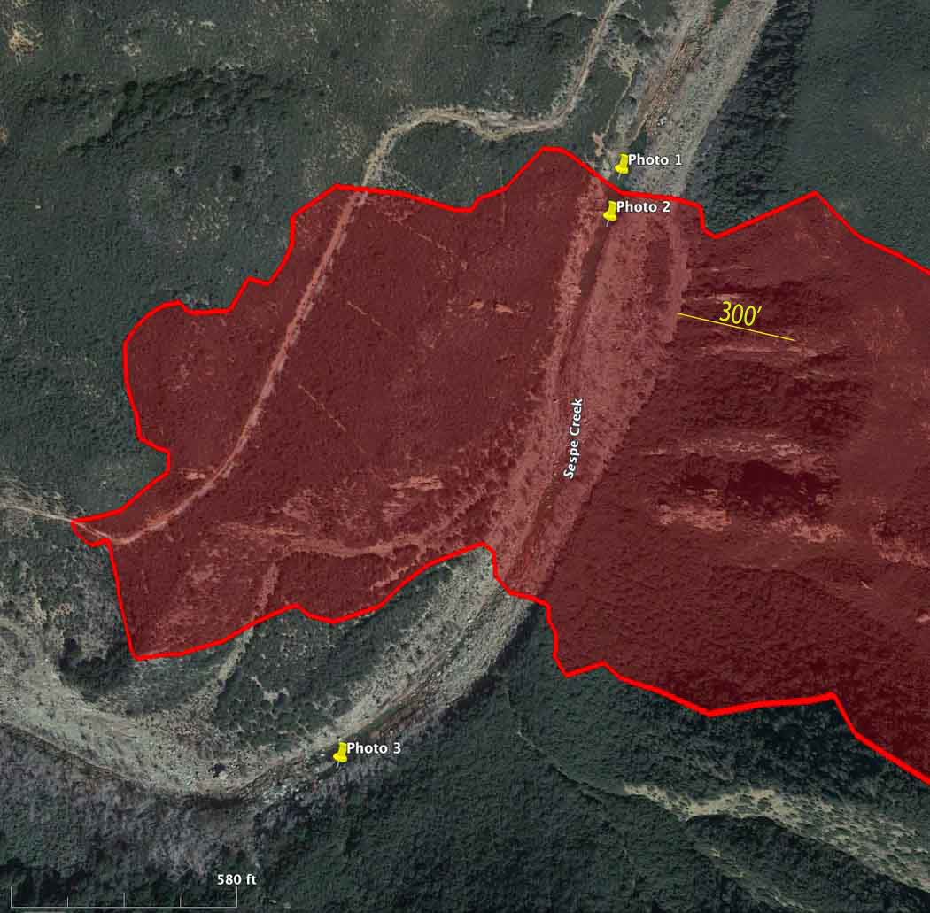
Map showing location of photos of retardant near Sespe Creek at the Howard Fire. The red area is the western side of the fire Oct. 12, 2022. The photo locations were obtained from the metadata in the iPhone photos.
A lawsuit filed Tuesday alleged that the US Forest Service has polluted waterways by firefighting air tankers inadvertently dropping fire retardant in or near waterways in violation of the Clean Water Act and a policy adopted by the Forest Service and other federal agencies in 2011. The policy requires that retardant not be dropped within 300 feet of a waterway on federal land.
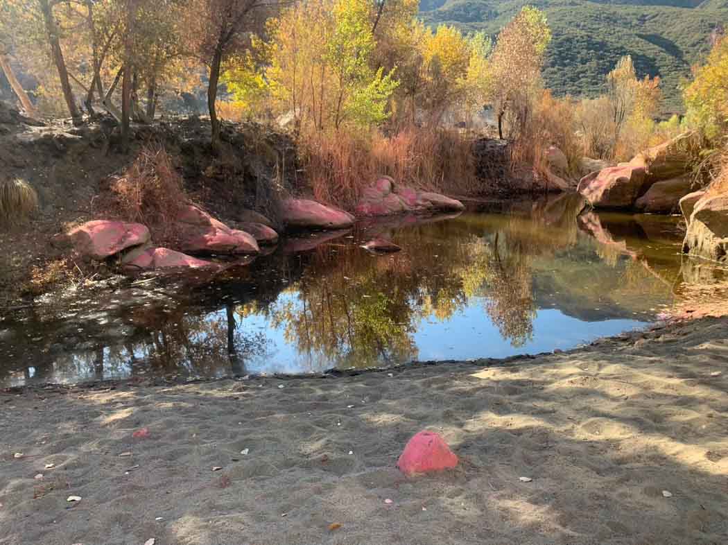
Photo 1. Retardant near Sespe Creek at the Howard Fire. Oct. 12, 2022. Peter Deneen.
Fire Aviation has acquired photos and a video that reportedly show signs of retardant being dropped into Sespe Creek on the Los Padres National Forest 8 miles northeast of Ojai, California October 8, 2022. The photos were shot by Pete Deneen on October 12, 2022 at the 85-acre Howard Fire. The creek is designated a “wild and scenic river” and is in a wilderness area.
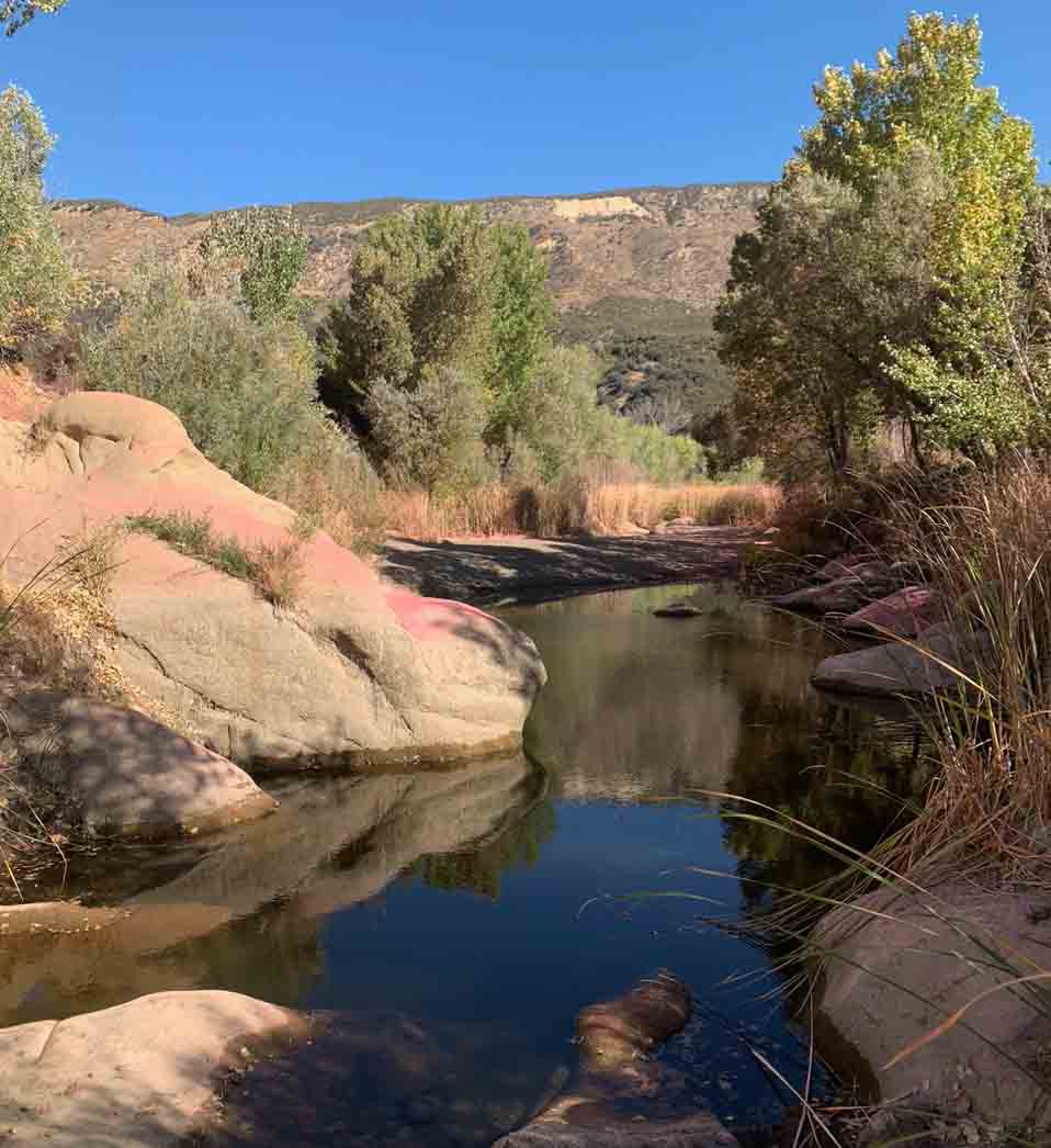
Photo 2. Retardant near Sespe Creek at the Howard Fire. Oct. 12, 2022. Peter Deneen.
The photos show retardant on rocks and other objects very close to water in Sespe Creek.
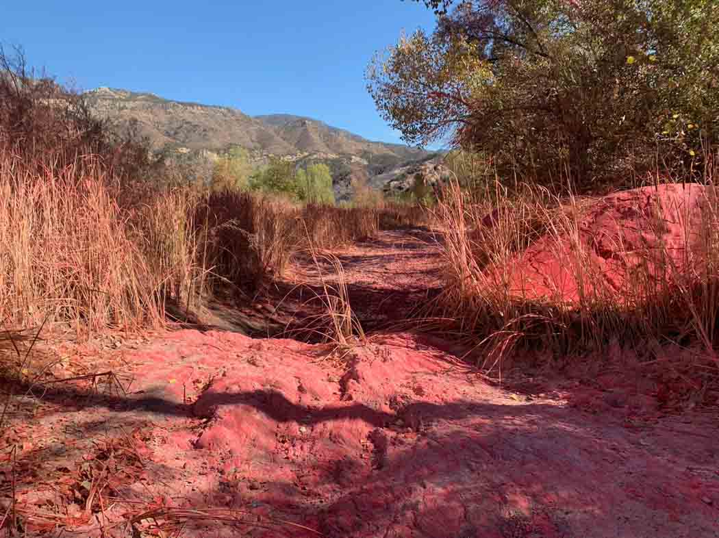
Photo 3. Retardant in a dry area of Sespe Creek at the Howard Fire. Oct. 12, 2022. Peter Deneen.
Some organisms, including aquatic threatened and endangered species or their habitats, can be adversely affected by retardants. In addition, retardant in water is a pollutant.
According to US Forest Service data, between 2012 and 2019, the Forest Service discharged retardant on at least 376 occasions totaling 761,282 gallons from aircraft directly into national forest waterways.
In the video below Mr. Deneen explains that there were two locations where retardant was dropped very close to the creek. In one case the aircraft may have turned as it was dropping to follow the creek for several hundred yards, or a second drop accounted for the retardant in the waterway.
The lawsuit was filed Oct. 11 by the Forest Service Employees for Environmental Ethics, FSEEE. In the group’s complaint they are seeking:
A declaration that the Forest Service’s placement of retardant in waterways is a violation of the Clean Water Act.
An injunction “to compel the Forest Service to comply with applicable environmental statutes, prevent irreparable harm, and satisfy the public interest.”
Reimbursement for FSEEE’s costs, expenses, expert witness fees, and attorney fees.
“Such further relief as may be just, proper, and equitable.”
More about FSEEE’s history of protesting retardant, and the federal government’s policy of retardant avoidance areas established in 2011.
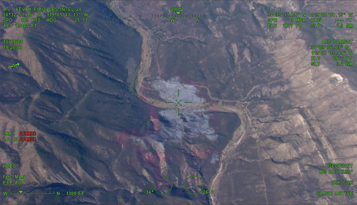
Howard Fire photo, looking west at 10:20 a.m. Oct. 9, 2022. FIRIS.
Aircraft were over the Howard Fire Sunday morning, including a lead plane and water-dropping helicopters.
The FIRIS OES 24 aircraft created an updated map at about 10 a.m. showing that the fire had grown to 85 acres, an increase of 10 acres since it was mapped Saturday evening.
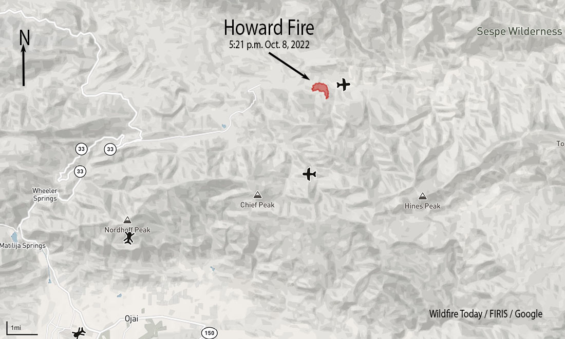
The incident is 8 miles northeast of Ojai, California. It is burning on both sides of Sespe Creek and the 20W13 Road, 6 miles east of Highway 33.
FIRIS was able to see fire retardant around much of the fire as well as hand-constructed and dozer-constructed fire line on portions of the perimeter. The video below is from FIRIS.
7:15 p.m. PDT October 8, 2022
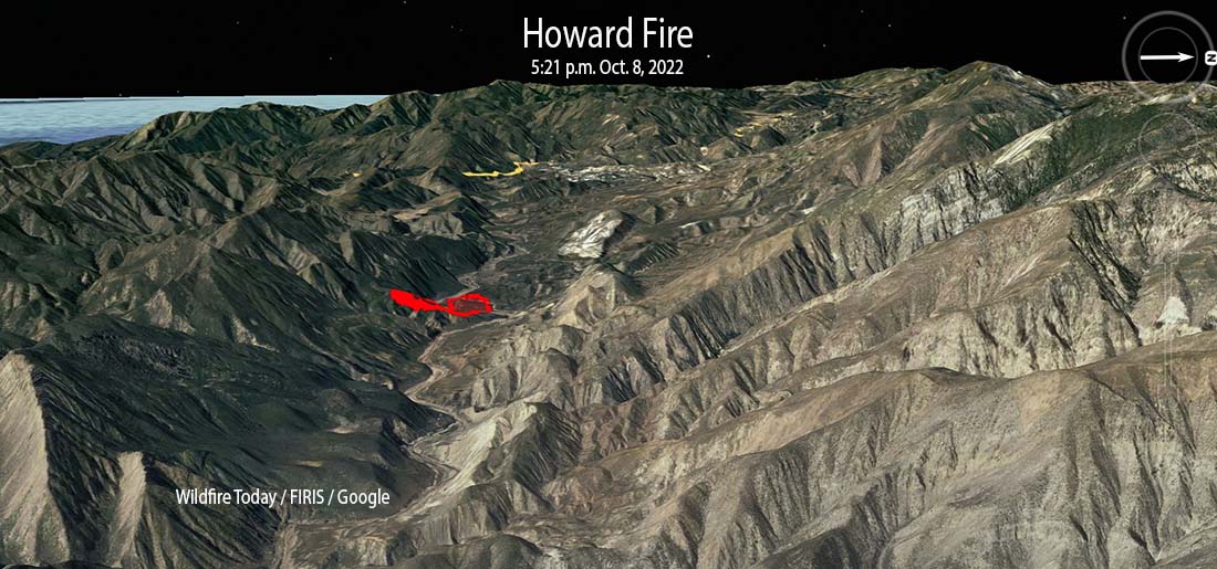
Howard Fire 3-D map (in red) 5:21 p.m. Oct. 8, 2022
The Howard Fire started Saturday afternoon in a remote area 8 miles northeast of Ojai, California. It is burning on both sides of Sespe Creek and the 20W13 Road 6 miles east of Highway 33.
At about 5:50 the incident commander estimated it had burned 80 to 85 acres. About half an hour earlier it was mapped by the FIRIS aircraft at 75 acres.
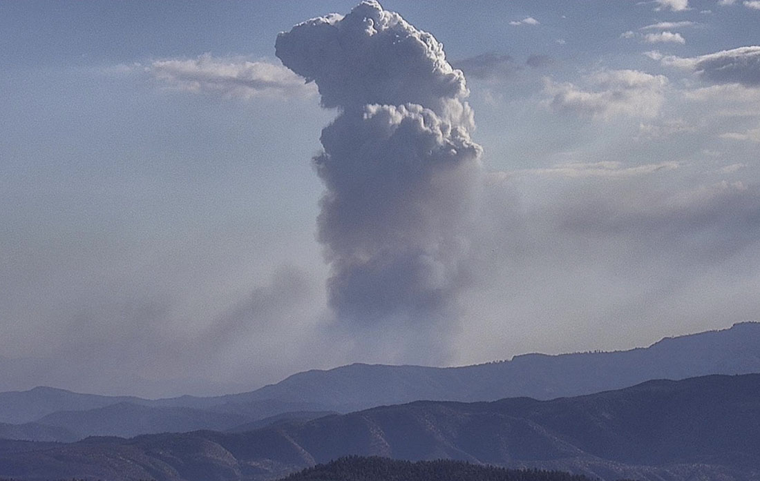
Howard Fire, looking southeast from Tecuyamtn1 camera at 4:32 p.m. Oct. 8, 2022. AlertWildfire.
For the first hour or so it was growing quickly putting up a convection column of smoke. Firefighters said it had the potential for 1,000 acres, but after aggressive initial attack by hand crews and aircraft in the difficult terrain, little smoke was seen as the sun was setting. Air tankers were able to complete a retardant line around 80 percent of the blaze by flight cutoff time. Orders were placed for aircraft to be available on the fire Sunday morning.
Several hikers were rescued by fire department helicopters.
Last year’s Caldor Fire and the community that was heavily damaged by it, Grizzly Flats, has been in the news recently. The latest is a piece aired on CBS’ 60 Minutes yesterday (see video below) about the fire southwest of Lake Tahoe, California. On August 16 Cap Radio wrote about the fuel treatment program the US Forest Service planned to conduct around the town, but barely started. Then on September 26 and 27 National Public Radio published articles about the failed project and difficulties in conducting prescribed fires.
The 13-minute piece on 60 Minutes concentrated on the initial attack of the fire, which was first reported at about 7 p.m. on August 14. One of the first challenges was gaining access, complicated by a washed out road and others that had not been maintained. According to a dispatch log the Incident Commander ordered everyone off the fire at 1:42 a.m., about seven hours after it started. The reason stated in the log was for “accountability.” 60 Minutes said the Forest Service told them it was for the safety of the firefighters. Later on day 2, according to 60 Minutes, the agency “dismissed a half dozen CAL FIRE engines and crews, letting most of them go before their replacements arrived.”
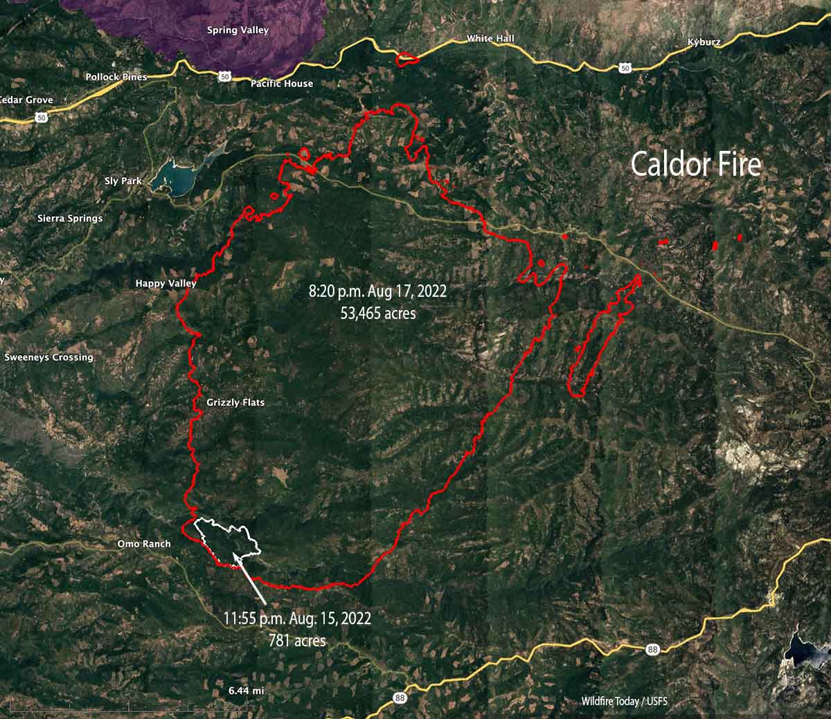
As you can see on the map below, about 29 hours after it started the fire was mapped at 781 acres. After another 44 hours it had burned through Grizzly Flats, growing to more than 55,000 acres.
Caldor Fire map, August 15 & 17, 2021.
Our take
I strongly believe in aggressive initial attack “with overwhelming force using both ground and air resources, arriving within the first 10 to 30 minutes when possible.” But it is difficult to criticize, especially a year later, an Incident Commander’s decision to pull everyone off a fire due to concerns about safety. Obviously the burning conditions were in favor of the fire that first night, not the firefighters. In 44 hours it grew from 781 to 53,465 acres while spotting more than a mile ahead according to mapping data from infrared aircraft.
If the Forest Service had completed the huge fuel treatment project they had promised around Grizzly Flats, that does not automatically mean no structures would have been destroyed in the community. Would the treatment have been a mile wide, reducing the number of burning embers landing in the town? Probably not. And it only takes one — landing in a leafy gutter, on a deck, on wooden steps, in a vent, on firewood, or dead grass near a structure and the home can be destroyed. When one home ignites, it becomes another ember generator, showering the rest of the community with ignition sources, resulting in the fire growing exponentially.
In September of 2021 Jack Cohen and Dave Strohmaier wrote about the Home Ignition Zone on Wildfire Today:
“Surprisingly, research has shown that home ignitions during extreme wildfires result from conditions local to a home. A home’s ignition vulnerabilities in relation to nearby burning materials within 100 feet principally determine home ignitions. This area of a home and its immediate surroundings is called the home ignition zone (HIZ). Typically, lofted burning embers initiate ignitions within the HIZ – to homes directly and nearby flammables leading to homes. Although an intense wildfire can loft firebrands more than one-half mile to start fires, the minuscule local conditions where the burning embers land and accumulate determine ignitions. Importantly, most home destruction during extreme wildfires occurs hours after the wildfire has ceased intense burning near the community; the residential fuels – homes, other structures, and vegetation – continue fire spread within the community.”
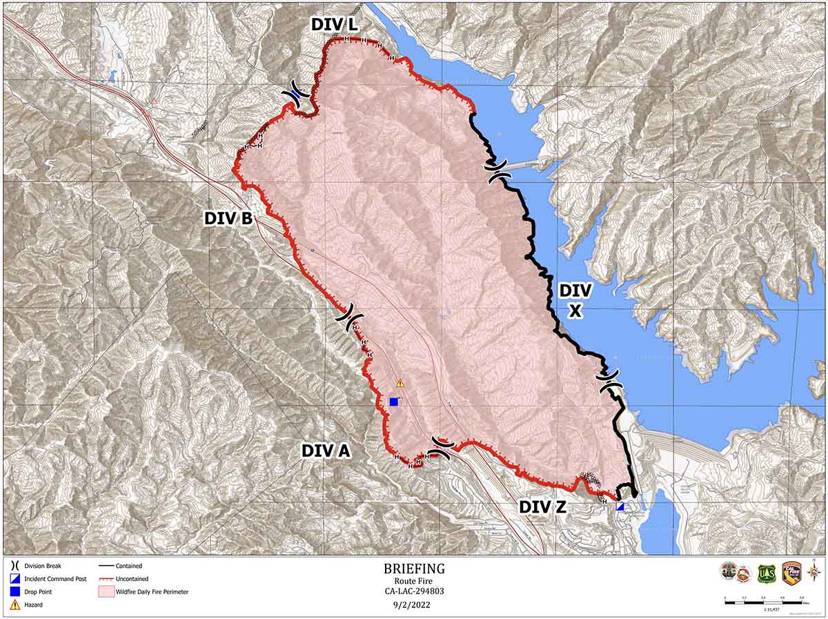
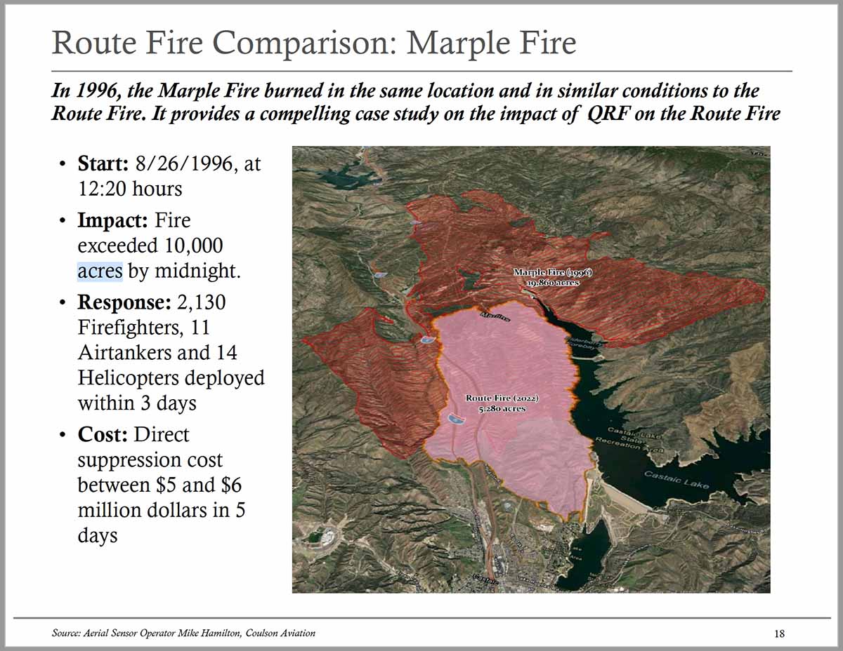
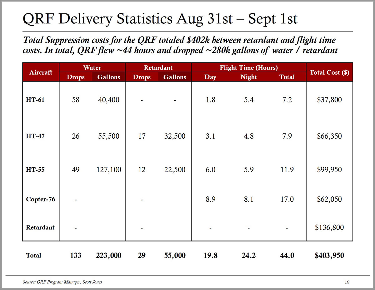
A report produced by the managers of Southern California’s Quick Reaction Force (QRF) of four helicopters concludes that the aggressive aerial attack working with the units on the ground likely limited the final size and cost of the Route Fire. The fire started at about noon on August 31, 2022 and ultimately burned 5,280 acres north of Los Angeles between Interstate 5 and Castaic Lake. (Download the 3.2 Mb report)
This is a different incident from the Route Fire that burned 454 acres a few miles away along Interstate 5 September 11, 2021. You may remember that fire as the one where 13 firefighters who were becoming rapidly entrapped were crammed into two US Forest Service engines and rescued with only moments to spare. There were 23 bodies in the two engines, with seating designed for five each. Another 11 firefighters not quite as close to the flames were rescued by Los Angeles County engines.
The four QRF helicopters are all staffed for 24-hour coverage and equipped for night flying. With most of their base funding supplied by Southern California Edison they are located in Orange, Los Angeles, and Ventura Counties. Two of the helicopters are CH-47 Chinooks, one is an S-61, and the fourth is an S-76 used for aerial supervision. The helicopters are dispatched as a unit along with a mobile fire retardant base and can drop water until the base is established. The fact that they can drop retardant 24 hours a day, when fixed wing aircraft can’t work the fire at night, can be a game changer. During the Route Fire the mobile retardant base did not have to travel, it was set up at its base about 10 miles from the fire.
Quick Reaction Force helicopters. From the QRF report.
The assignment given to the QRF by Los Angeles County Fire Department on the Route fire was for it to stop the spread to the north. The S-61 was tasked to hold a particular location on the fire, using water from the adjacent Castaic Lake. It averaged of 696 gallons per drop.
The two Chinooks dropped averages of 2,434 gallons of water per drop and 1,896 gallons of retardant per drop. The three suppression helicopters flew an average of 9 hours each that afternoon and into the night, dropping 223,000 gallons of water and 55,000 gallons of retardant. The S-76 was used for 17 hours. The total cost of the retardant and flight time for the four ships was $403,950.
Map of 2022 Route and 1996 Marple Fires. From the QRF report.
The report compares the Route Fire to the 1996 Marple Fire which started in about the same location at the same time of the day and time of year in similar weather conditions. By midnight the Marple Fire had exceeded 10,000 acres and continued spreading for two or three days until it was stopped at 19,860 acres.
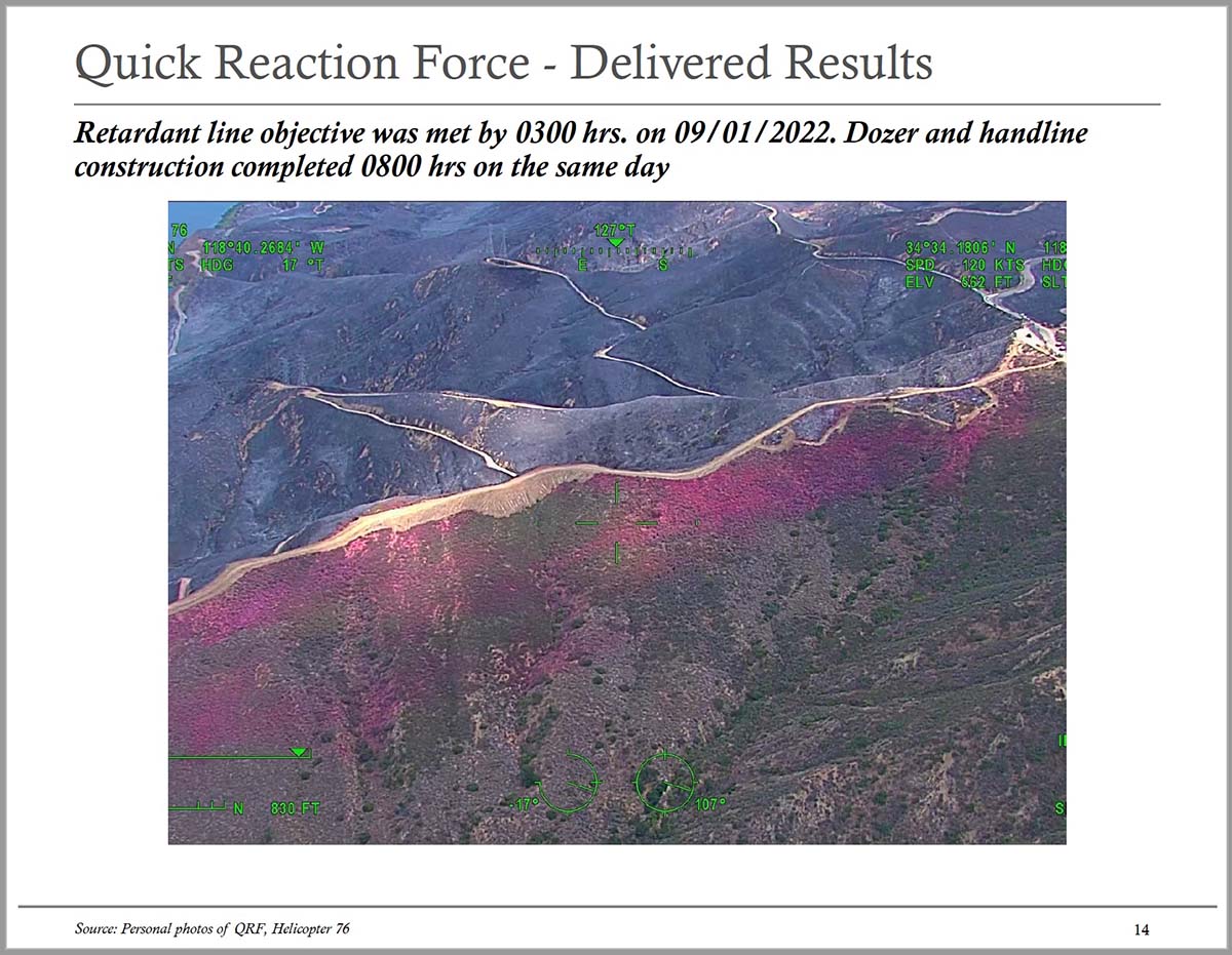
Retardant line on north side of Route Fire, Sept. 1, 2022. From the QRF report.
In contrast, the spread of the Route Fire was stopped at 8 a.m. on Day 2. The three helicopters dropped water and retardant much of the night to hold it at a ridge on the north side, allowing hand crews and dozers to complete fire line.
It is very difficult to compare the suppression costs of two fires that occurred 26 years apart, but the authors of the QRF report estimated that the cost of the Marple Fire in today’s dollars would be somewhere between $70 million and $140 million. The cost of the Route Fire was $7 million to $8 million.
The fire has burned 76,781 acres and destroyed 78 structures near Foresthill, California
Mosquito Fire as seen looking ENE from the Auburn camera at 5:32 p.m. Sept. 8, 2022. AlertWildfire.
US Forest Service investigators working to determine the cause of the Mosquito Fire have taken possession of one of Pacific Gas and Electric’s transmission poles and attached equipment. According to a report released by the company September 24, the Forest Service said the fire started in the area of one of the company’s power lines on Forest Service land. PG&E is conducting their own investigation of the cause of the fire.
The agency has not released the cause of the fire which has burned 76,781 acres and destroyed 78 structures near Foresthill, California 35 miles northeast of Sacramento.
In October, 2020 investigators from the California Department of Forestry and Fire Protection looking for the cause of the Zogg Fire southwest of Redding seized PG&E equipment. The fire which burned 56,338 acres, destroyed 204 structures, and resulted in four civilian fatalities, was caused by a tree contacting a power line operated by PG&E. In September, 2021 the company was charged with manslaughter and dozens of other charges related to the fire.
In 2018 investigators seized parts of a 99-year old PG&E transmission tower at the origin of the Camp Fire which burned into Paradise, California killing at least 85 people and making thousands homeless. In May, 2019 CAL FIRE announced that their investigators determined the fire was caused by the power line.
The Wall Street Journal (subscription) reported that investigators attributed more than 1,500 fires to PG&E power lines and hardware between June 2014 and December 2017. In 2021 we put together a list of 18 fires, mostly large, attributed to failures on PG&E power lines between 1999 and 2020.
Firefighters are mopping up the Mosquito Fire, which received substantial amounts of rain last week. It is still staffed by 1,248 personnel.