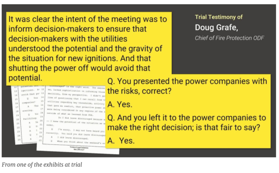
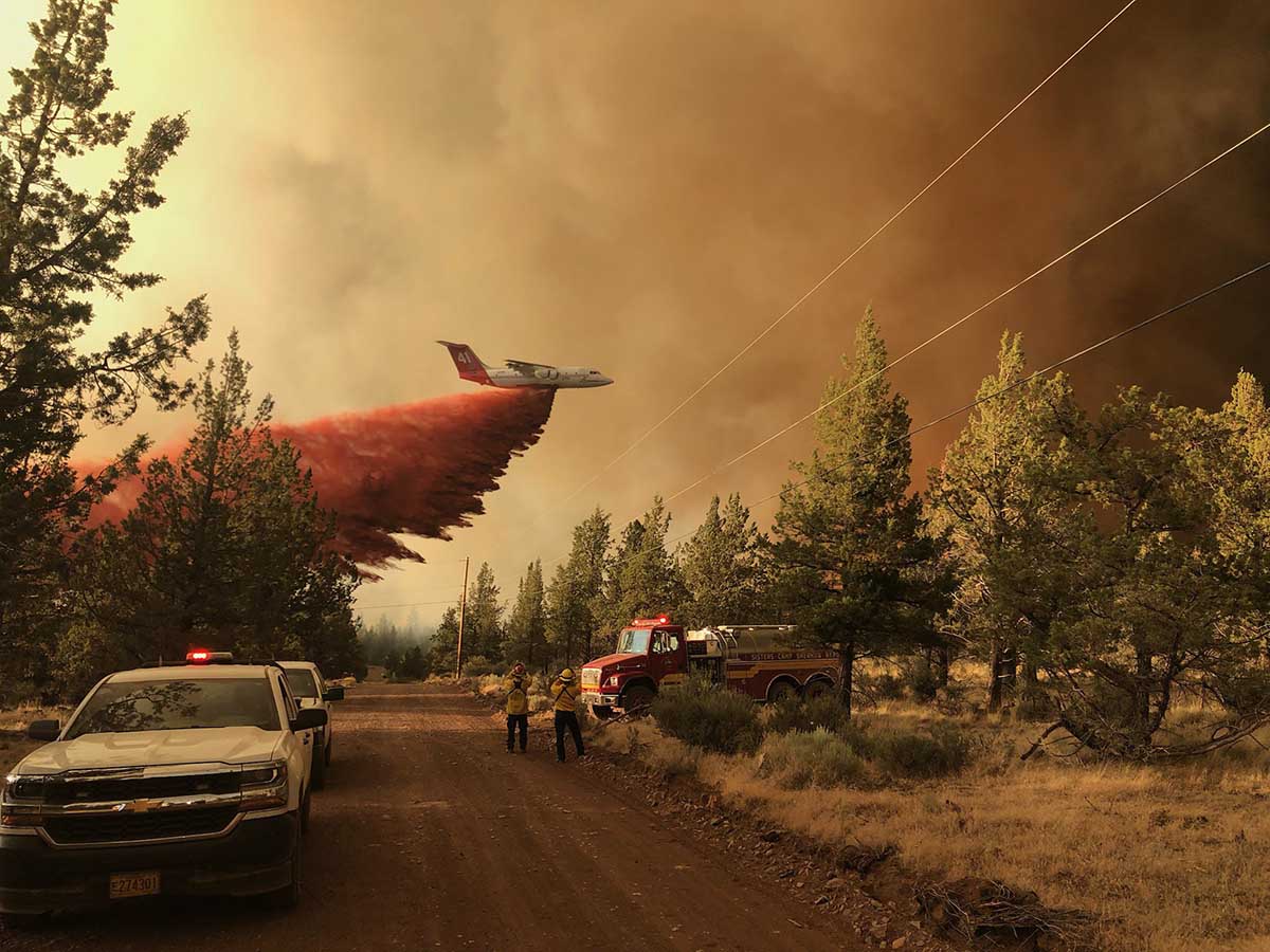
PacifiCorp, an electric utility provider in the Pacific Northwest that was found guilty of gross negligence and recklessness in the 2020 Labor Day fires in Oregon, has agreed to pay $299 million to victims of fires in southern Oregon, according to a report by the Oregonian.
PacifiCorp, which owns Pacific Power, lost a similar lawsuit back in June for causing fires in the northern part of the state. The jury in Multnomah County Circuit Court in Portland found the utility liable for four of the Labor Day 2020 fires, after its powerlines ignited fires that burned about 2,500 properties in western Oregon. The 12-person jury determined that PacifiCorp was negligent for causing the Santiam, Echo Mountain, South Obenchain, and 242 fires after a 7-week class action trial. (The final verdict in that trial is posted on our DOCUMENTS page.)
GOES-17 photo of smoke from wildfires in Washington, Oregon, and California at 5:56 p.m. PDT Sept. 8, 2020. This image was captured during the strong east wind event. NASA photo
A year ago, PacifiCorp settled another case out of court with two families who sued over the Archie Creek Fire, which burned more than 130,000 acres in Douglas County in 2020.
Tuesday’s settlement is unprecedented in Oregon and wraps up a 3-year legal battle that has financially and emotionally exhausted residents who lost homes and property in the firestorm.
The Archie Creek Fire leveled communities along the North Umpqua River east of Roseburg, and it was just one of numerous huge fires ignited during the Labor Day weekend windstorms.
The Labor Day fires collectively burned more than 1.2 million acres in Oregon, destroyed upwards of 5,000 homes and structures, and killed nine people. PacifiCorp, Oregon’s second largest utility, did not shut down power to any of its 600,000 customers during the windstorm — despite the fact they were repeatedly warned by emergency officials to power down their lines, which were implicated in six separate fires.
Archie Creek Fire map, 2:35 p.m. PDT Sept. 22, 2020.
Some 220 families and individuals sued, alleging negligence that caused the Archie Creek Fire. The $299 million settlement amounts to an average of about $1.35 million per family in the lawsuit, though individual claims vary widely. Victims will pay attorneys’ fees, estimated at 30 to 40 percent of the settlement. The settlement agreement avoids a consolidated trial that was scheduled for January 30 and shields PacifiCorp from much larger jury awards that would likely have included punitive damages.
The company had asked state regulators to protect it from the costs of future lawsuits over destructive wildfires; in the request to the Oregon Public Utility Commission in June, PacifiCorp also wanted ratepayers to pay for $90 million the jury found the company liable for. That request drew harsh criticism from wildfire victims, lawyers, and ratepayer advocates, who questioned the company’s motives and the proposal’s legality.
According to a report by The Hill, PacifiCorp said the settlement amounts are consistent with those previously estimated and established in accounting reserves for the wildfires. “PacifiCorp has settled and is committed to settling all reasonable claims for actual damages as provided under Oregon law,” the company said in a statement.
09/13/2020 — the Labor Day fires were among the worst natural disasters in Oregon’s history. They killed nine people, burned more than 1,875 square miles (4,856 square kilometers) and destroyed upwards of 5,000 homes and other structures.
Plaintiffs’ lawyers in the Labor Day fires’ litigation have criticized the utility for legal obstruction — instead of promptly settling with victims. They’ve sought legal sanctions against the company for withholding information about the origins of the fires, denying access to investigations after the fires, and limiting what employees could say in depositions.
The company still faces numerous lawsuits related to the 2020 fires, including a trial scheduled for January for seven timber companies that lost property in the Archie Creek Fire — their claims were not part of this week’s settlement.
Multnomah County Circuit Court Judge Steffan Alexander has scheduled three trials early in 2024 to consider damages for another 20 plaintiffs; he has ordered the company and more than 1000 other plaintiffs into mediation — which could dramatically increase the utility’s financial liability. Total damages sought in lawsuits related to the 2020 fires is about $8 billion.
The National Park Service plans to replant sequoia groves in Sequoia and Kings Canyon National Parks, where fires in 2020 and 2021 caused lasting damage to sequoia groves on federal land, but environmentalist groups in California say it would set a legal precedent and be a huge mistake.
Four groups filed suit against the NPS on November 17, saying the agency’s efforts violate the law, because designated wilderness areas prohibit human involvement in the ecosystem — even if it includes planting trees.
Three fires in two years that killed giant sequoia trees. The darker green areas represent groves of giant sequoias.
Surveys of sequoias on NPS land found that in 2020 and 2021, almost 20 percent of all giant sequoias in their natural range that were over 4 feet in diameter or more were killed by fire (and neglect) or were expected to die in the next few years. In 2020, surveyors estimated that 10 to 14 percent of the entire Sierra Nevada population of giant sequoias over 4 feet in diameter were killed in the Castle Fire. The following year, the KNP Complex and the Windy Fire burned between 2200 and 3600 sequoias over 4 feet in diameter; those sequoias were killed or are expected to die within 5 years.
CBS News reported on the project a year ago:
The NPS announced the seedling-planting project and said it was “concerned that natural regeneration may not be sufficient to support self-sustaining groves into the future, particularly as the fires killed an unprecedented number of reproductive sequoia trees in the groves themselves.”
Chad Hanson, director of the John Muir Project, one of the groups that is suing, disputes that conclusion. Sequoias actually “depend on high-intensity fire in order to reproduce effectively,” Hanson told CNN. “Nature doesn’t need our help. We are not supposed to be getting involved with tending it like a garden.”
Advocates at Wilderness Watch, Sequoia Forest Keeper, and the Tule River Conservancy first sued the NPS in September to stop a separate project by the agency to cut and burn trees in the same designated wilderness areas, cutting on about 1000 acres of forest land and designating 20,000 additional acres as available to “manager-ignited fires and associated activity,” according to the complaint.
“Recently burned groves are RESTORING THEMSELVES — as they have done for more than one hundred centuries!” according to the Sequoia Portal, whose mission is to add existing roadless areas of the Sequoia National Park, National Forest, and National Monument to the National Wilderness Preservation System. “Millions of sequoia seedlings carpet these burned groves,” says the Portal. “Do they think the public is stupid enough to think that any agency can replace full-grown 3200-year-old red barked sequoias? ALL the iconic ancient giants started as tiny seedlings, and they are already growing — immediately seeded by their scorched giant sequoia parents! As it has always been in the groves. And the majority of the largest giants are NOT DEAD.”
The John Muir Project, a nonprofit focused on protecting federal forests, joined the lawsuit on November 17, amending it to include the sequoia replanting project as part of the complaint. The groups now jointly accuse the NPS of illegally encroaching on federally protected land in both of the projects.
Firefighter on the 2021 Windy Fire applies water on a burning giant sequoia. InciWeb photo
The complaint in U.S. District Court in Fresno is an addendum to a suit filed earlier this year that challenged the NPS for other work in wilderness areas of Sequoia & Kings Canyon National Parks. Besides planting seedlings, NPS crews have been thinning and burning around sequoia groves to reduce wildfire risk, according to the San Francisco Chronicle.
Both the fire-prevention work and the tree-replanting project followed in the aftermath of fires that wiped out unprecedented numbers of sequoias.
NPS staff declined to comment on the lawsuit, but confirmed that replanting had already begun in two sequoia groves back in mid-October, before the latter complaint was filed.
“The Park Service has to abide by the 1964 Wilderness Act,” said Kevin Proescholdt, conservation director at Wilderness Watch. “We should still allow these natural ecosystems to respond as they want to the changes brought about by the changing climate. The more that agencies will allow natural fire to burn and perform its role, the better these wilderness forests will be,” he said.
The groups claim the projects were approved after required processes of environmental review and public engagement were circumvented by declaring they were “emergency” projects that would not have to meet those requirements.
The NPS said in its project announcement it would replant only in areas that field surveys showed insufficient natural regeneration to successfully re-establish, as they would if they hadn’t experienced severe fire effects in recent fires.
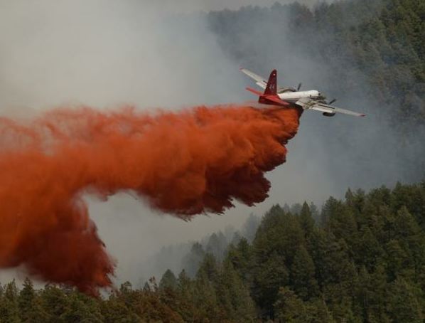
A federal judge ruled Friday that the U.S. government can continue using retardant to fight wildfires, despite his finding that it does pollute streams in violation of federal law. Banning retardant could cause greater environmental damage from wildland fires, said U.S. District Judge Dana Christensen in court in Missoula, Montana.
The judge agreed with U.S. Forest Service officials who testified that dropping retardant from aircraft into areas near waterways was sometimes necessary to protect lives and property, according to an AP report posted by KEZI-TV.
2019 retardant drop, photo by Kari Greer
Christensen’s ruling resulted from yet another lawsuit filed last year by an environmentalist group trying to protect fish over people when they learned that the Forest Service had dropped retardant into waterways — what they claim was hundreds of times over the last decade.
Retardant is often crucial in slowing the progression of wildfires, which have grown larger and more destructive and more frequent as climate change and a burgeoning wildland/urban interface advance the danger of fires across the West — and other parts of the world.
Firefighters observe a retardant drop by an RJ85 airtanker. DOI photo.
Though environmental groups claim fire suppression efforts allowed incursions of retardant more than 200 times over the last 10 years, fire officials reply that such situations happened accidentally — and in less than 1 percent of the thousands of retardant drops ordered each year.
During this case — yet another in the decades-long battle by environmental groups against the use of retardant — a coalition including Paradise, California said stopping the use of retardant would risk lives, homes, and forests. (The 2018 Camp Fire killed 85 people and destroyed the town of Paradise.) There’s a good story online about this coalition by AerialFire Magazine.
A neighborhood on Debbie Lane in Paradise, California, before and after the Camp Fire that started November 8, 2018. The homes were 14 to 18 feet apart.
“This case was very personal for us,” said Paradise Mayor Greg Bolin on Friday. “Our brave firefighters need every tool in the toolbox to protect human lives and property against wildfires, and today’s ruling ensures we have a fighting chance this fire season.”
“Retardant lasts and even works if it’s dry,” said Scott Upton, a former region chief and air attack group supervisor for CAL FIRE. “Water is only so good because it dries out. It does very well to suppress fires, but it won’t last.”
KDVR-TV reported that the Oregon-based group Forest Service Employees for Environmental Ethics (FSEEE) argued in its most recent lawsuit that the Forest Service was disregarding the Clean Water Act by continuing to use retardant without taking adequate precautions to protect streams and rivers. Launched by Jeff DeBonis in 1989 in Eugene, Oregon, the group (nationalforestadvocates.org) says it has about 10,000 members; it publishes a quarterly called Forest Magazine and pays its director Andy Stahl over $91K annually. The organization receives a substantial part of its support from a governmental unit and/or the general public.
Andy Stahl
FireRescue1 reported that FSEEE claims wildfire retardant drops are expensive, ineffective, and a growing source of pollution for rivers and streams. “There’s no scientific evidence that it makes any difference in wildfire outcomes,” said Andy Stahl. “This is like dumping cash out of airplanes, except that it’s toxic and you can’t buy anything with it because it doesn’t work.”
The case has been followed closely by officials in California, where an extremely wet winter is likely to stoke the growth of early-season light fuels. “This is going to destroy towns and many communities in California, if they allow this to go through,” said Paradise Mayor Greg Bolin, whose town was razed by the Camp Fire five years ago. “To maybe save a few fish, really?”
The Smokey Wire is a Forest Service and public lands policy blog administered by Sharon Friedman, Ph.D., forest geneticist, Forest Service retiree, and former Chair of both the Forest Policy Committee and Forest Science and Technology Board at the Society of American Foresters. In a recent post about this retardant case, she commented on a piece in the San Joaquin Valley Sun published about a month ago in April, which noted that if the court sided with FSEEE, the USFS would have to obtain a special permit under the Clean Water Act to use retardant from aircraft — a lengthy process that would span multiple years. During the lawsuit, the USFS initiated the process of receiving such a permit from the EPA with the current 300-foot buffer zone for retardant drops from affected waterways.
While following a lead plane, Tanker 118, an HC-130H, begins a retardant drop on the 2018 Ferguson Fire — photo by Kari Greer
In response, FSEEE argued that 300 feet was an arbitrary number. Despite its argument that the USFS had originally created the 300-foot buffer proposal out of thin air, FSEEE then asked the Court for a 600-foot buffer zone.
U.S. District Judge Dana Christensen
Judge Christensen noted then that a ruling was pending, because fire season in the West is pending. He expressed skepticism at the nationwide impact of siding with FSEEE and rejected its push for an extended buffer zone. “The last thing I want to do is start imposing magic numbers in terms of buffer zones,” he said. “I mean, that’s way out of my wheelhouse. But I don’t know what the Forest Service did to come up with a 300-feet buffer, and you’re describing it as being essentially nothing. It’s a magic number. And I will tell you, if this Court imposes a 600-foot buffer, that is truly a magic number. So that’s probably not going to happen.”
USFS attorney Alan Greenberg said the Forest Service uses retardant on about 5 percent of wildfires — and less than 1 percent of those drops end up in contact with water.
Christensen said that stopping the use of retardant could result in greater harm from wildfires — including to human life and property and to the environment. (Note that his ruling was not nationwide — it’s limited to the 10 western states where FSEEE alleged harm from pollution into waterways.)
In the lawsuit (online HERE), FSEEE specifies that “the chemical retardants used by wildland firefighting agencies are tested and approved by the United States Department of Agriculture’s Missoula Technology and Development Center, located in this Division. The Forest Service also has a Fire Sciences Lab and Smokejumper Base in this Division. Plaintiff has members who reside in this Division, and who have been injured by the Forest Service actions and activities complained of in this Complaint. Moreover, the Forest Service has discharged aerial fire retardant into navigable waters in this Division without a National Pollution Discharge Elimination System (NPDES) permit.”
Airtanker drops retardant
After the lawsuit was filed the Forest Service applied to the EPA for a permit that would allow it to continue using retardant without breaking the law. That process could take years. Christensen ordered federal officials to report every six months on their progress; no word yet on whether the USFS will still pursue that EPA permit or whether they have to continue reporting to Christensen about it.
Fire retardant covers a road sign on Barrett Lake Road in the eastern San Diego town of Dulzura, California, site of the Border 32 Fire that burned 4,456 acres between August 31 and Sept 8, 2022. Photo Credit: Josh Stotler
Health risks to firefighters or other people who come into contact with fire retardant are considered low, according to a 2021 risk assessment. But the chemicals can be harmful to some fish, frogs, crustaceans, and other aquatic species. One government study found misapplied retardant could adversely affect dozens of species including crawfish, spotted owls, and threatened fish such as shiners and suckers. To prevent risk, officials and pilots have avoided drops within 300 feet (92 meters) of waterways. Retardant may be applied inside those zones only when if life or public safety is threatened. Of 213 documented instances of fire retardant contacting water between 2012 and 2019, 190 were accidental and the remainder were necessary to protect lives or property, officials said.
The Chetco Bar Fire on July 13, 2017 taken from a helicopter during the Type 3 Incident Commander’s first recon flight.
Two lawsuits have been filed in federal court for firing operations that burned private land during the Chetco Bar Fire that eventually burned more than 191,000 acres on land managed by the US Forest Service and private landowners in southwest Oregon.
The suit, under the Tucker Act for inverse condemnation, seeks compensation for “property taken” by the USFS in its use and management of the Chetco Bar Fire. It alleges that between August 17 and 20, 2017 the USFS conducted firing operations on their property “to achieve its natural resource management objectives, and to otherwise manage its lands”.
“USFS employed planned ignitions in the form of large-scale backfires designed to artificially grow the naturally occurring wildfire to sizes much larger than if it has been left to burn naturally,” say the twocomplaints filed October 21. “The large-scale planned ignitions on the Chetco Bar Fire ignored political and property boundaries and used Plaintiffs’ nonfederal resources as backfire fuel, imposing the costs of the natural resource management objectives upon Plaintiffs.”
The Chetco Bar Fire started from a lightning strike during a storm on June 24 and 25, 2017 and was first reported by an airline pilot 17 days later on July 12.
The attorney representing the landowners is Quentin Rhodes in Missoula, who is not your typical barrister. He worked as a wildland firefighter for eight seasons between 1987 and 1994, serving on the Helena Hotshot crew and later as a smokejumper at West Yellowstone and Missoula. He told Wildfire Today in 2012 that he was in the first planeload of jumpers on the South Canyon Fire in Colorado in 1994, the fatal fire on which 14 wildland firefighters were entrapped and killed. In 2012 he represented owners of a Montana ranch who won a $750,000 judgement against the state of Montana when firefighters on the Ryan Gulch Fire employed firing operations which burned 900 acres of the ranch’s land.
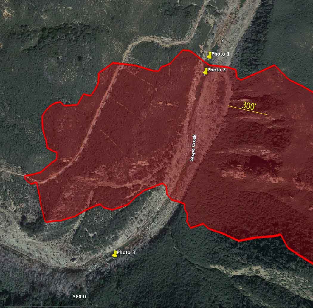
Map showing location of photos of retardant near Sespe Creek at the Howard Fire. The red area is the western side of the fire Oct. 12, 2022. The photo locations were obtained from the metadata in the iPhone photos.
A lawsuit filed Tuesday alleged that the US Forest Service has polluted waterways by firefighting air tankers inadvertently dropping fire retardant in or near waterways in violation of the Clean Water Act and a policy adopted by the Forest Service and other federal agencies in 2011. The policy requires that retardant not be dropped within 300 feet of a waterway on federal land.
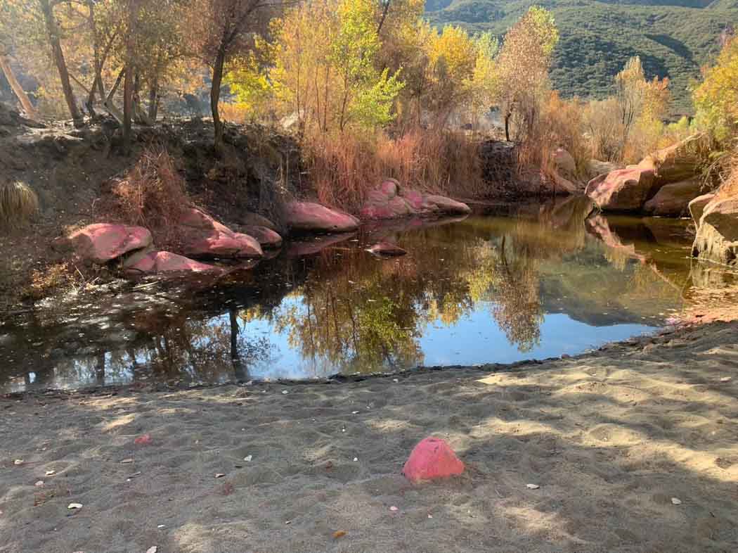
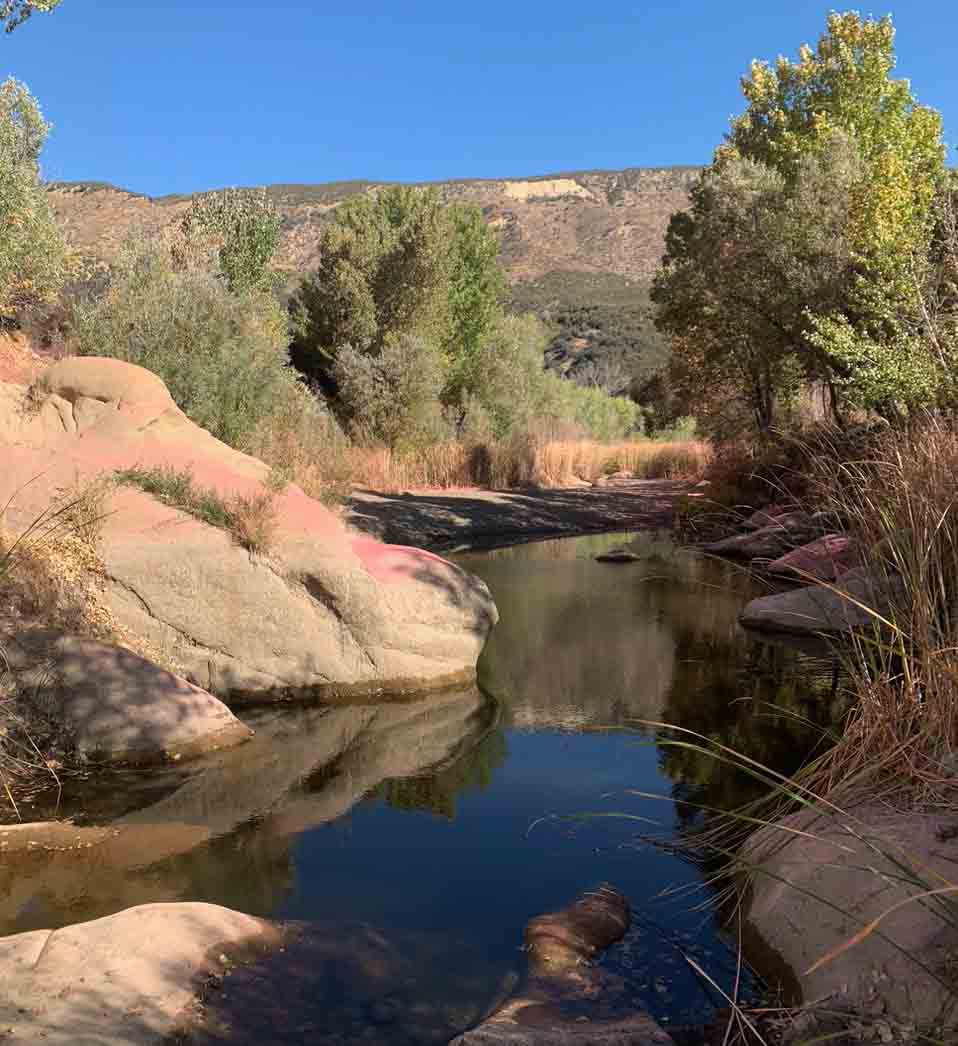
Photo 1. Retardant near Sespe Creek at the Howard Fire. Oct. 12, 2022. Peter Deneen.
Fire Aviation has acquired photos and a video that reportedly show signs of retardant being dropped into Sespe Creek on the Los Padres National Forest 8 miles northeast of Ojai, California October 8, 2022. The photos were shot by Pete Deneen on October 12, 2022 at the 85-acre Howard Fire. The creek is designated a “wild and scenic river” and is in a wilderness area.
Photo 2. Retardant near Sespe Creek at the Howard Fire. Oct. 12, 2022. Peter Deneen.
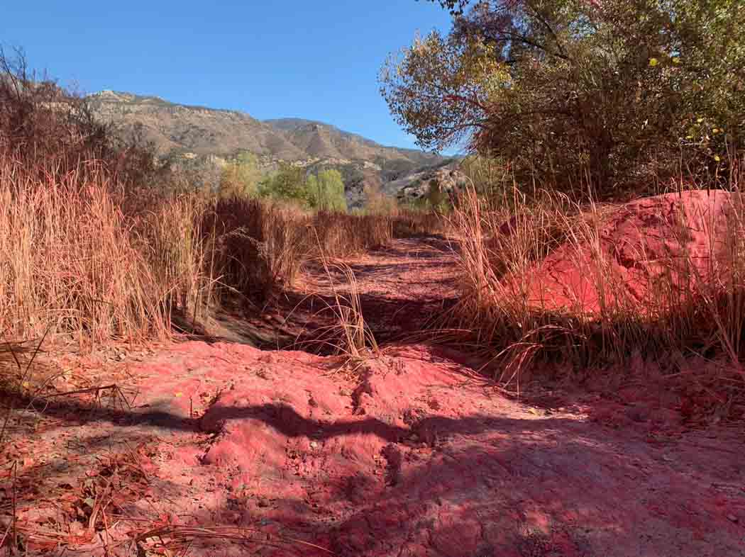
The photos show retardant on rocks and other objects very close to water in Sespe Creek.
Photo 3. Retardant in a dry area of Sespe Creek at the Howard Fire. Oct. 12, 2022. Peter Deneen.
Some organisms, including aquatic threatened and endangered species or their habitats, can be adversely affected by retardants. In addition, retardant in water is a pollutant.
According to US Forest Service data, between 2012 and 2019, the Forest Service discharged retardant on at least 376 occasions totaling 761,282 gallons from aircraft directly into national forest waterways.
In the video below Mr. Deneen explains that there were two locations where retardant was dropped very close to the creek. In one case the aircraft may have turned as it was dropping to follow the creek for several hundred yards, or a second drop accounted for the retardant in the waterway.
The lawsuit was filed Oct. 11 by the Forest Service Employees for Environmental Ethics, FSEEE. In the group’s complaint they are seeking:
A declaration that the Forest Service’s placement of retardant in waterways is a violation of the Clean Water Act.
An injunction “to compel the Forest Service to comply with applicable environmental statutes, prevent irreparable harm, and satisfy the public interest.”
Reimbursement for FSEEE’s costs, expenses, expert witness fees, and attorney fees.
“Such further relief as may be just, proper, and equitable.”
More about FSEEE’s history of protesting retardant, and the federal government’s policy of retardant avoidance areas established in 2011.
Air Tanker 41, a BAe-146, drops retardant. BLM photo.
An environmental group filed a lawsuit in a Montana federal court Tuesday alleging that the US Forest Service has polluted waterways by inadvertently dropping fire retardant in or near waterways. The retardant was dropped by aircraft under contract with the Forest Service while assisting wildland firefighters on the ground.
The suit says government data released earlier this year showed more than 760,000 gallons of fire retardant was dropped into waterways between 2012 and 2019. The lawsuit alleges the continued use of retardant from aircraft violates the Clean Water Act and requests a judge to declare the pollution illegal.
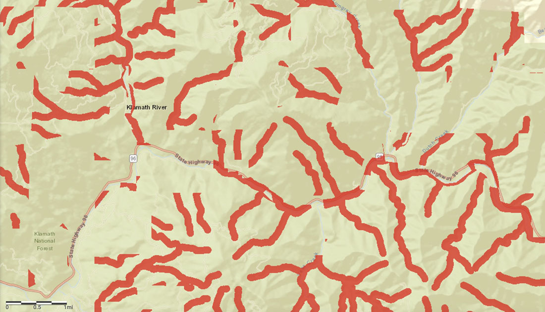
Example of retardant avoidance areas (red) in Northern California along Hwy. 96 near Klamath River.
The Forest Service has established retardant avoidance areas along waterways where the liquid is not supposed to be applied. This puts buffer zones around waterways and habitat for some threatened, endangered, and sensitive species in order to avoid applying retardant in those areas. When they were first established in 2011 it resulted in approximately 30 percent of USFS lands being off limits for retardant while fighting fire. There is an exception if human life or public safety is threatened. The policy was the result of an Environmental Impact Statement (EIS) that studied the use of retardant and how it affects water resources and certain plant and wildlife species. The EIS was written in response to a July, 2010 decision by U. S. District Court Judge Donald Molloy in a lawsuit filed in 2008 by the Forest Service Employees for Environmental Ethics.
The same organization, FSEEE, filed the new case yesterday. An attorney in Missoula, MT who specializes in environmental law, Tim Bechtold, will be representing FSEEE. Presiding over the case will be District Court Judge Dana Christensen. He joined the court in 2011 after a nomination from President Barack Obama. Before, he was a partner in the firm of Christensen, Moore, Cockrell, Cummings, and Axelberg, in Kalispell, Montana. One of the 15 practice areas the firm deals with today is environment and natural resources.
In 2012 FSEEE issued a statement criticizing the use of air tankers on fires, claiming it is “immoral”. The group argued that aerial firefighting is too dangerous and ineffective and that “retardant doesn’t save homes; proper construction and landscaping save homes.”