It seems hard to believe, but the the first firefighters and a sheriff’s deputy dispatched to the Marshall Fire southeast of Boulder, Colorado could not immediately find it. On December 30 they arrived four minutes after being dispatched at about 11 a.m. to a report of smoke and a downed power line, according to a time line compiled by Colorado Public Radio, but they did not see smoke or flames until 11 minutes after they were at the reported location.
They may have been distracted at first by what they thought was a downed power line on Marshall Road. They told the dispatcher the line is “hanging down low enough that it can touch a vehicle or trucks and people are attempting to go underneath it.” Later they found out that it was a telecommunications line that did not pose any fire danger, but apparently it was a physical hazard for motorists.
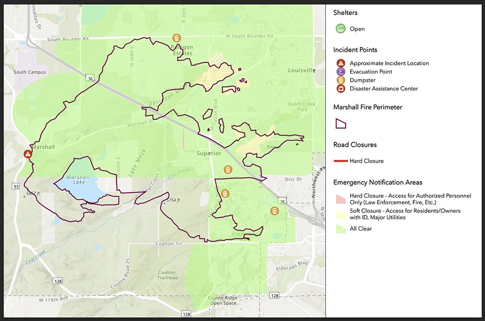
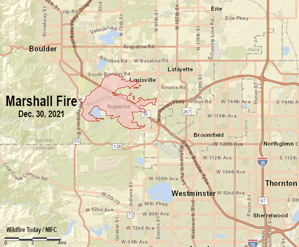
To see all articles on Wildfire Today about the Marshall Fire, including the most recent, click here, https://wildfiretoday.com/tag/marshall-fire/
It is possible that the 11-minute delay in finding the fire was due the reported location being incorrect. Or the fire was small and light fuel such as short grass was burning which did not produce a great deal of smoke and may have been kept low to the ground by the very strong wind. Later the blaze moved into heavier fuel, and in spite of the wind produced a convection column topped by condensation.

During the hour before it started, firefighters were sent to two other vegetation fires which were north of Boulder. Even with the very strong winds firefighters were able to stop both before they grew large.
These incidents may have reduced the number of fire resources that were available when the Marshall fire took off, spreading very rapidly pushed by winds gusting at 60 to more than 100 mph hour depending on the location.
Before the fires started a great deal of dust was being kicked up by the wind, then it became a mix of smoke and dust. Check out the dust blowing in this video with the fire in the background:
Last video. I’m moving!!! pic.twitter.com/GsesauMpGf
— Eric English (@EricEnglish777) December 30, 2021
The wind was not predicted very far in advance for the Boulder area and there was no Red Flag Warning in effect. At 3 a.m. on December 30, about 8 hours before the Marshal Fire started, the forecasting data and models started to become clear — the wind would move from the mountains into the areas northwest of Denver. An existing wind warning was revised.
From CPR.org:
“It wasn’t a slam dunk high wind event,” said Jennifer Stark, meteorologist in charge at the Boulder office. “But ingredients were really coming together, and once we saw the latest model runs that forecaster on the midnight shift, put out that warning. And we were expecting wind gusts up around 90 miles an hour.”
Before the day was over winds would gust up to 115 mph at one location.
The warning, however, was not technically a “red flag” warning, which is specific to fire danger, and requires three elements: strong winds, cured fuels and relative humidities less than 15% for three hours or longer.
“So we had two of the ingredients,” said Stark. “We had the fuels that were cured and dry, and we had the very strong winds, but the relative humidities were actually a forecast to be in the lower 20 percents. So we did not go with the red flag warning.”
The lack of a red flag warning was a surprise to Philip Higuera, Professor of Fire Ecology at the University of Montana, Missoula, who is currently a visiting fellow at CU Boulder. He said there should be objective criteria for red flag warnings, but it should be revisited in an era of climate change.
“One of the things that we’re seeing broadly in the fire world is that the systems that we have in place are largely developed based on our past experiences,” said Higuera. “We’re increasingly seeing examples where those systems are either less applicable or no longer applicable under the conditions we’re experiencing now, in a world that’s changing rapidly.”
Still, the warning that was issued discussed the danger of a possible fire spreading rapidly, given months of drought in the region combined with the winds.
It is easy to say after the event, but wildland firefighters know that the three major factors that affect the spread of a fire are weather, fuels, and topography. Wildfires generally do not suddenly become rapidly spreading unless very strong winds are present, and they can make up for less than extreme fuel and topography.
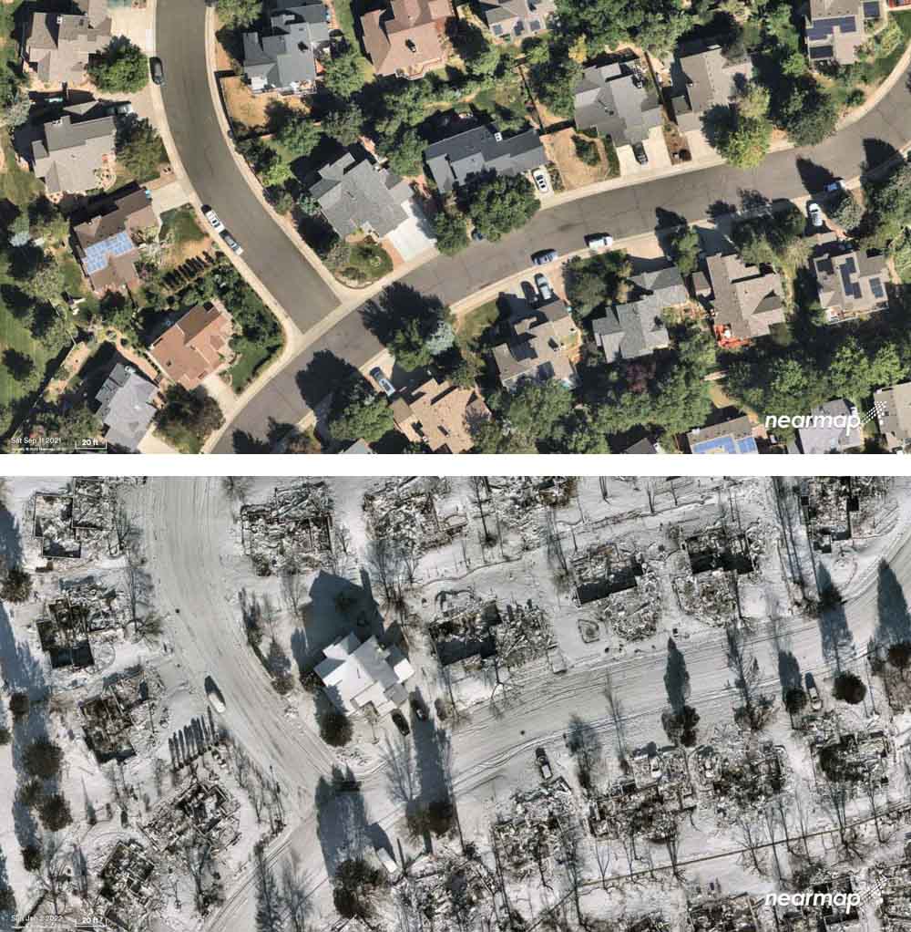
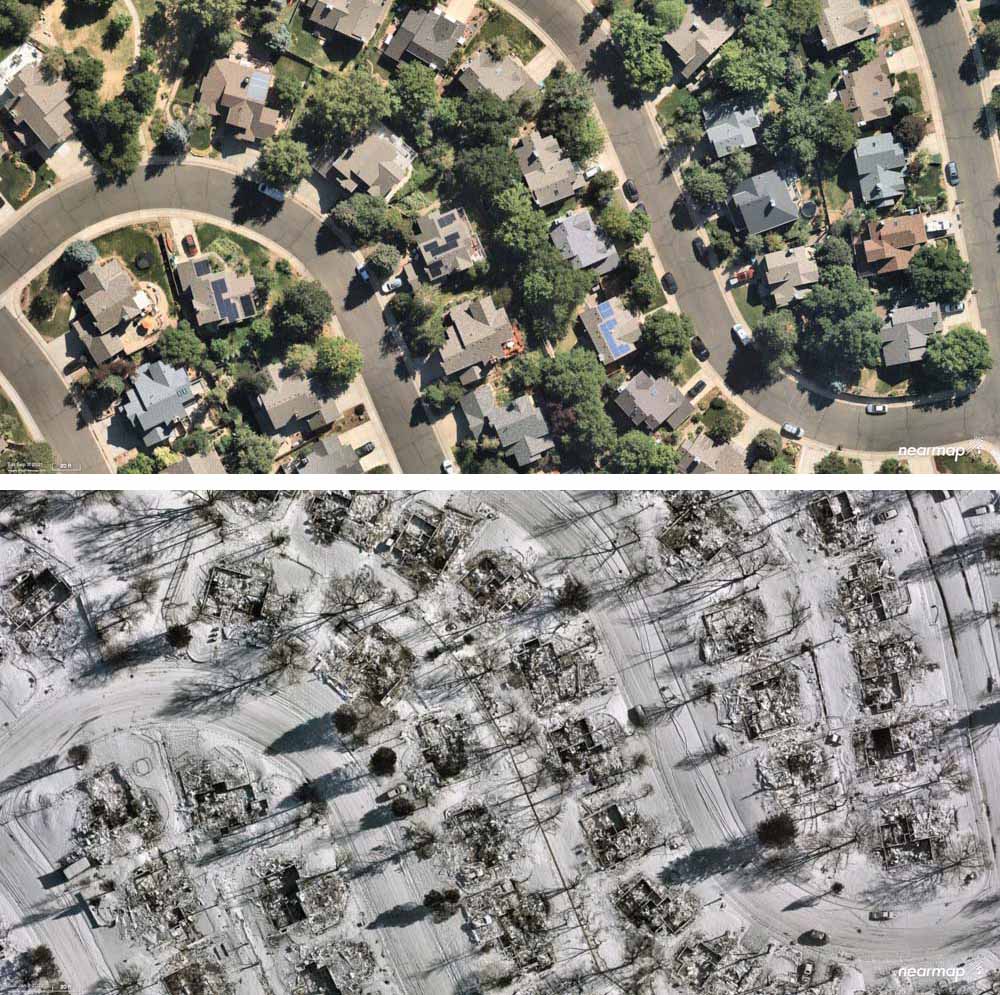
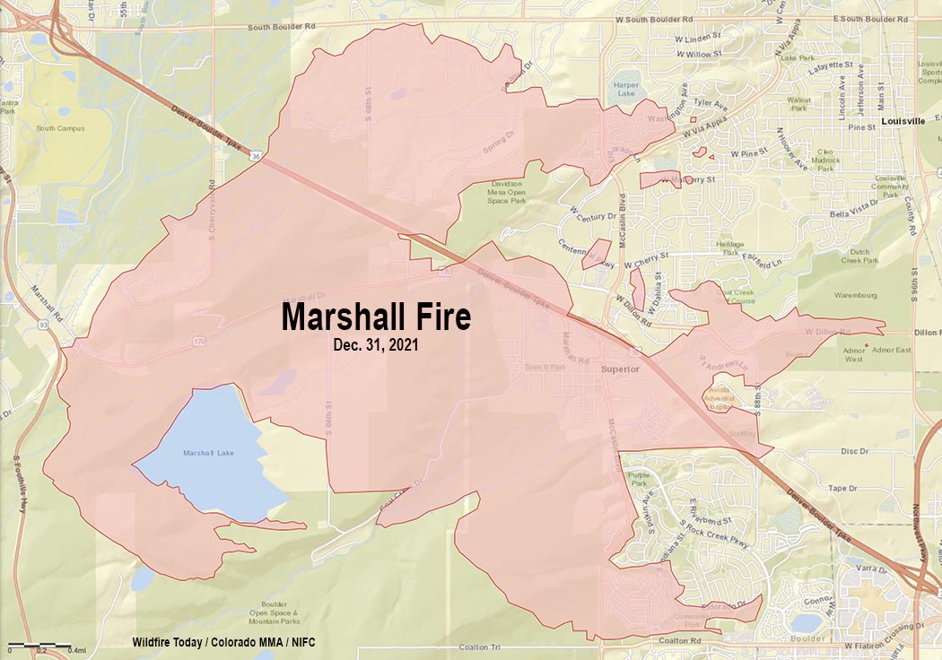
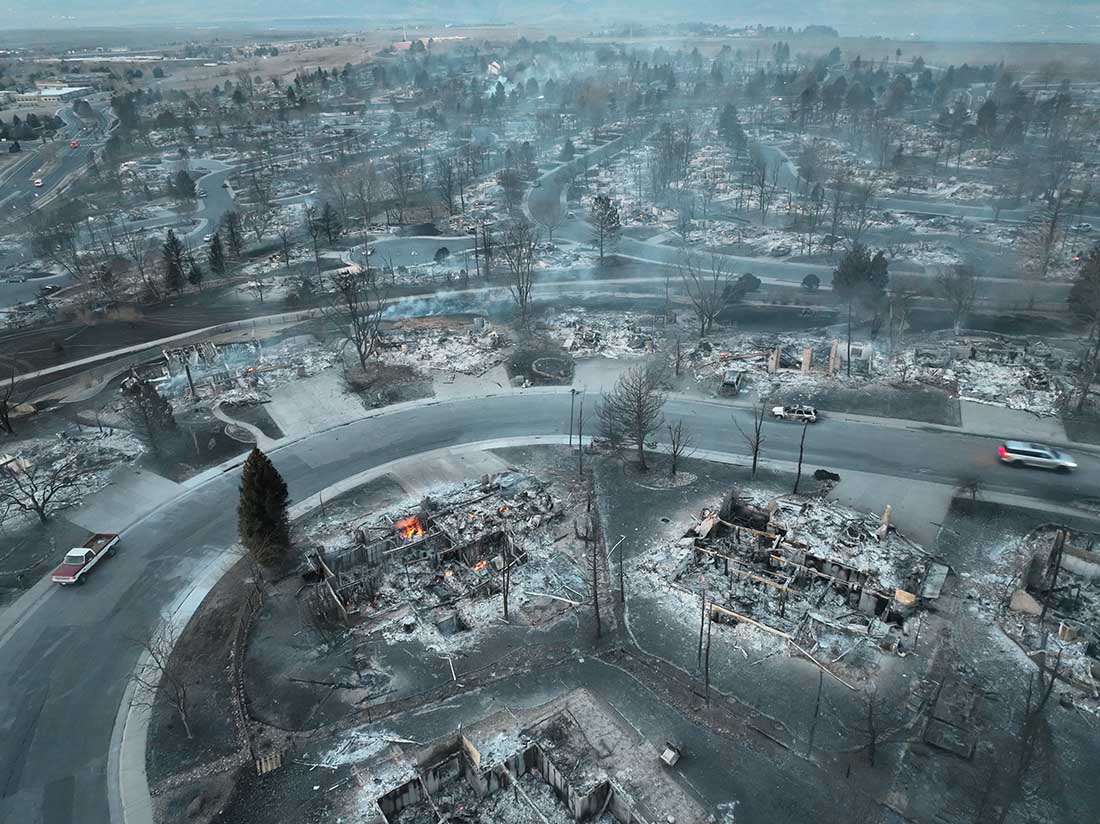
The lengthy drought and much less than average precipitation on the Front Range of Colorado in October, November, and December helped set the stage. At 1:30 p.m. on Dec. 30 the relative humidity near Superior where much of the destruction occurred was low, 24 percent, and the temperature was 44 degrees. The extreme wind was able to overwhelm the factors of low but not extreme RH, a temperature generally not associated with fire storms, light to medium vegetation, and benign topography. The 991 structures that burned added a great deal to the fuel load. As buildings were consumed, radiant and convective heat ignited houses that in some places were only 10 to 20 feet apart, while burning embers blown by the wind lit spot fires far ahead in the home ignition zones, on structures, leaf-filled gutters, and vents, as well as bone dry lawns and mulch beds which in some cases spread to and ignited the homes.
The Boulder Office of Emergency Management declined to release to CPR a recording of the initial phone call reporting the fire.
Unlike most states, in Colorado county sheriffs have statutory responsibility to coordinate wildland fire response within their county. Sheriff Joe Pelle said his investigation had not found a power line near the point of origin. At least one search warrant has been served on a compound in that area where investigators have been seen.
The final determination of the cause is going to be huge. That, combined with snow covering the point of origin is part of the reason the investigators are taking their time, being careful and meticulous. Many of the nearly 1,000 structures destroyed are valued at $600,000 to $800,000 so regardless of what is found attorneys will no doubt file law suits.