Estimated value of those Boulder County, Colorado homes is $513 million
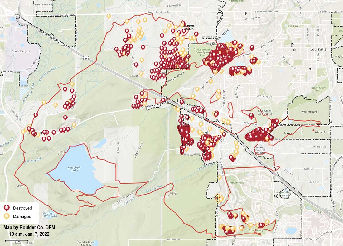
Map of structures damaged or destroyed during the Marshall Fire which started December 30, 2021. Map accessed at 10 a.m. MST January 7, 2021.
An interagency damage assessment of the Marshall Fire southeast of Boulder, Colorado updated Jan. 6 has found 1,084 destroyed residences and 149 that were damaged. The total countywide estimated value of residential damage is $513,212,589. The updated numbers for commercial structures are 7 destroyed and 30 damaged. The total value of commercial damage is still being calculated. The commercial structures included a shopping center and the Element Hotel.
Residential Structures
City of Louisville: 550 destroyed, 43 damaged; actual value of residential damage is approximately $229,199,184
Town of Superior: 378 destroyed, 58 damaged; actual value of residential damage is approximately $152,757,462
Unincorporated Boulder County: 156 destroyed, 48 damaged; actual value of residential damage is approximately $131,255,944
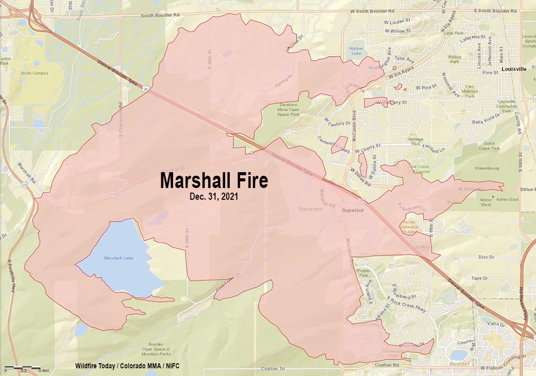
Within hours it burned more than 6,000 acres and nearly 1,000 structures southeast of Boulder, Colorado
FEDEX truck blown over by wind, with the Marshall Fire in the distance. Photo by Alyssa Lundgren, Dec. 30, 2021.
It seems hard to believe, but the the first firefighters and a sheriff’s deputy dispatched to the Marshall Fire southeast of Boulder, Colorado could not immediately find it. On December 30 they arrived four minutes after being dispatched at about 11 a.m. to a report of smoke and a downed power line, according to a time line compiled by Colorado Public Radio, but they did not see smoke or flames until 11 minutes after they were at the reported location.
They may have been distracted at first by what they thought was a downed power line on Marshall Road. They told the dispatcher the line is “hanging down low enough that it can touch a vehicle or trucks and people are attempting to go underneath it.” Later they found out that it was a telecommunications line that did not pose any fire danger, but apparently it was a physical hazard for motorists.
It is possible that the 11-minute delay in finding the fire was due the reported location being incorrect. Or the fire was small and light fuel such as short grass was burning which did not produce a great deal of smoke and may have been kept low to the ground by the very strong wind. Later the blaze moved into heavier fuel, and in spite of the wind produced a convection column topped by condensation.
Marshall Fire south of Boulder, CO. Posted Thursday at 12:26 p.m. MST by County Commissioner Claire Levy.
During the hour before it started, firefighters were sent to two other vegetation fires which were north of Boulder. Even with the very strong winds firefighters were able to stop both before they grew large.
These incidents may have reduced the number of fire resources that were available when the Marshall fire took off, spreading very rapidly pushed by winds gusting at 60 to more than 100 mph hour depending on the location.
Before the fires started a great deal of dust was being kicked up by the wind, then it became a mix of smoke and dust. Check out the dust blowing in this video with the fire in the background:
The wind was not predicted very far in advance for the Boulder area and there was no Red Flag Warning in effect. At 3 a.m. on December 30, about 8 hours before the Marshal Fire started, the forecasting data and models started to become clear — the wind would move from the mountains into the areas northwest of Denver. An existing wind warning was revised.
From CPR.org:
“It wasn’t a slam dunk high wind event,” said Jennifer Stark, meteorologist in charge at the Boulder office. “But ingredients were really coming together, and once we saw the latest model runs that forecaster on the midnight shift, put out that warning. And we were expecting wind gusts up around 90 miles an hour.”
Before the day was over winds would gust up to 115 mph at one location.
The warning, however, was not technically a “red flag” warning, which is specific to fire danger, and requires three elements: strong winds, cured fuels and relative humidities less than 15% for three hours or longer.
“So we had two of the ingredients,” said Stark. “We had the fuels that were cured and dry, and we had the very strong winds, but the relative humidities were actually a forecast to be in the lower 20 percents. So we did not go with the red flag warning.”
The lack of a red flag warning was a surprise to Philip Higuera, Professor of Fire Ecology at the University of Montana, Missoula, who is currently a visiting fellow at CU Boulder. He said there should be objective criteria for red flag warnings, but it should be revisited in an era of climate change.
“One of the things that we’re seeing broadly in the fire world is that the systems that we have in place are largely developed based on our past experiences,” said Higuera. “We’re increasingly seeing examples where those systems are either less applicable or no longer applicable under the conditions we’re experiencing now, in a world that’s changing rapidly.”
Still, the warning that was issued discussed the danger of a possible fire spreading rapidly, given months of drought in the region combined with the winds.
It is easy to say after the event, but wildland firefighters know that the three major factors that affect the spread of a fire are weather, fuels, and topography. Wildfires generally do not suddenly become rapidly spreading unless very strong winds are present, and they can make up for less than extreme fuel and topography.
The lengthy drought and much less than average precipitation on the Front Range of Colorado in October, November, and December helped set the stage. At 1:30 p.m. on Dec. 30 the relative humidity near Superior where much of the destruction occurred was low, 24 percent, and the temperature was 44 degrees. The extreme wind was able to overwhelm the factors of low but not extreme RH, a temperature generally not associated with fire storms, light to medium vegetation, and benign topography. The 991 structures that burned added a great deal to the fuel load. As buildings were consumed, radiant and convective heat ignited houses that in some places were only 10 to 20 feet apart, while burning embers blown by the wind lit spot fires far ahead in the home ignition zones, on structures, leaf-filled gutters, and vents, as well as bone dry lawns and mulch beds which in some cases spread to and ignited the homes.
The Boulder Office of Emergency Management declined to release to CPR a recording of the initial phone call reporting the fire.
Unlike most states, in Colorado county sheriffs have statutory responsibility to coordinate wildland fire response within their county. Sheriff Joe Pelle said his investigation had not found a power line near the point of origin. At least one search warrant has been served on a compound in that area where investigators have been seen.
The final determination of the cause is going to be huge. That, combined with snow covering the point of origin is part of the reason the investigators are taking their time, being careful and meticulous. Many of the nearly 1,000 structures destroyed are valued at $600,000 to $800,000 so regardless of what is found attorneys will no doubt file law suits.
Evacuation orders lifted for Louisville and Superior
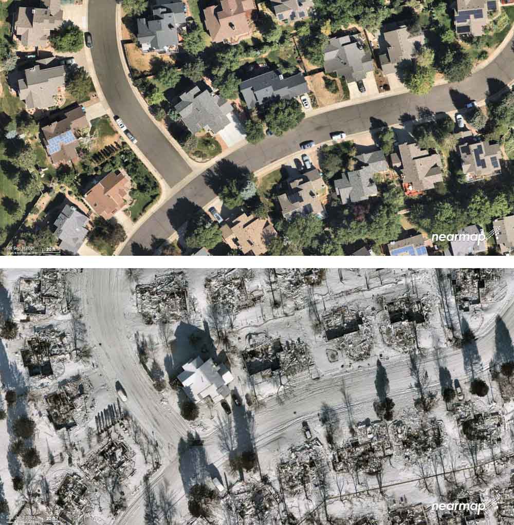
Superior, Colorado, before and after the Marshall Fire, Sept. 11, 2021 and Jan. 2, 2022. Nearmap.
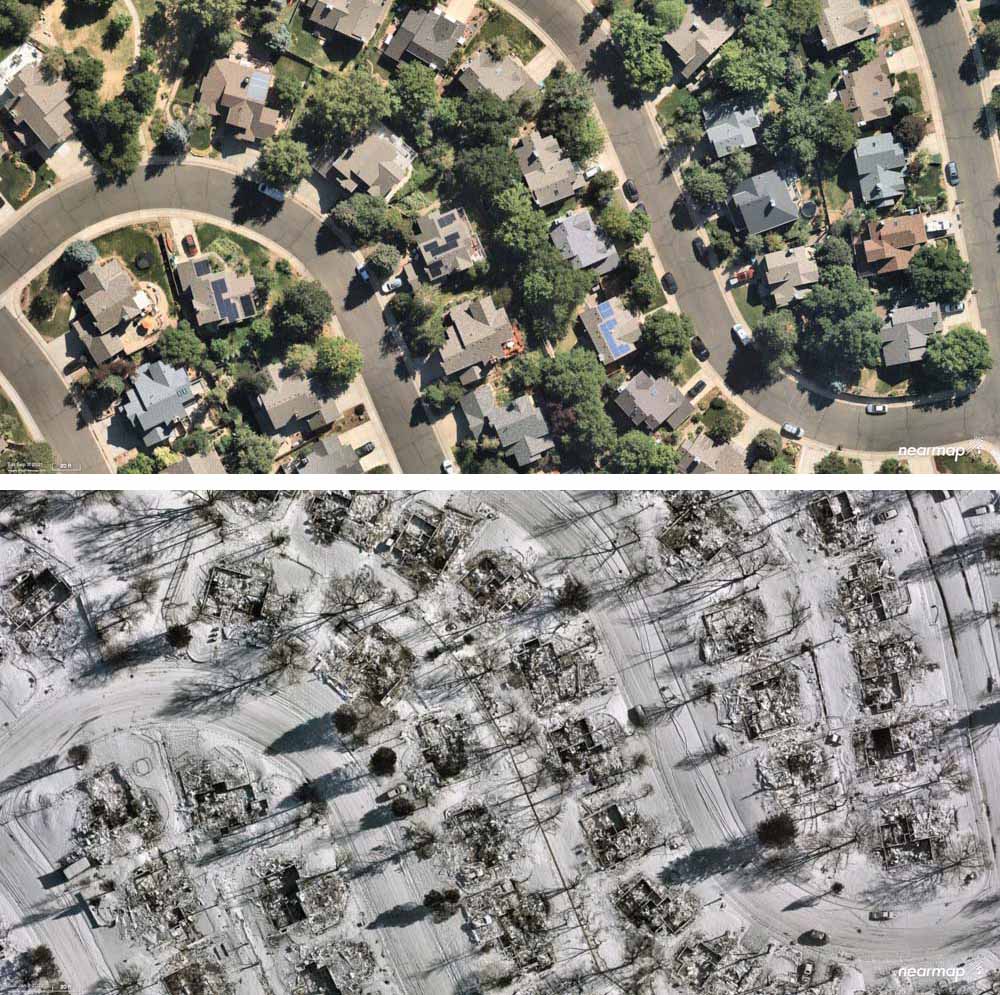
Aerial photos taken of Superior, Colorado before and after the devastating December 30 Marshall Fire show the physical impact on the structures. Most of the homes within the 6,219-acre perimeter were destroyed as the fire was pushed by winds gusting, depending on the location, at 60 to 100 mph while the relative humidity was in the 20s.
Superior, Colorado, before and after the Marshall Fire, Sept. 11, 2021 and Jan. 2, 2022. Nearmap.
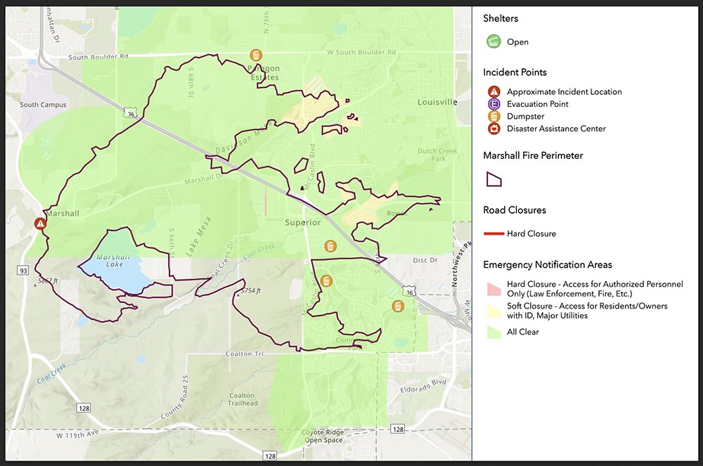
At 12 p.m. Wednesday the evacuation order for Louisville was lifted. Superior’s closures were lifted at 6 a.m. Boulder County’s map at 3:30 p.m. Wednesday showed “all clear” and no closures in effect in the fire area.
Investigators have been searching for the two persons still reported as missing at two locations. In the 5900 block of Marshall Road in unincorporated Boulder County they have located partial human remains of an adult. Investigators from both the Sheriff’s Office and Coroner’s Office continue to actively work at this scene.
The search in the 1500 block of S. 76th Street, Superior is ongoing.
There have been no other reports of fatalities tied to the fire.
The Boulder County Sheriff’s office said there are no updates on the continuing investigation into the cause and origin of the Marshall Fire. The weather has been a factor in the speed at which the investigations are able to be conducted.
The Disaster Assistance Center is available for anyone impacted by the fire. It is located at 1755 South Public Road, Lafayette, and is open from 9 a.m. to 7 p.m. every day.
President Joe Biden will be in Boulder County Friday to see the damage caused by the fire.
Below is information from Boulder County about how to help:
We know our community’s heart is huge, and everyone wants to help. Official sites are unable to accept any material donations — please do not bring these to shelters or other disaster support locations.
Victims most need money. While some families have gofundme accounts set up by friends, we cannot verify the authenticity of each of these, and we are concerned about fraud. The very best way to ensure victims receive funding, without tax implications, is to donate to www.coloradogives.org
Can’t give money, but want to volunteer? There will be many needs in the months ahead. Please do not self-dispatch to disaster areas. Please registers at: https://coloradoresponds.communityos.org/. This state clearinghouse will strive to match volunteers with community and individual needs.
Due to the recent fires, BCPH is working to determine the health risk current air quality poses. There are several air monitoring stations in Boulder and Longmont that measure regional air quality which currently report to be moderate to good. Information: https://t.co/prFb56Kfpnpic.twitter.com/6Hbnfh0Q4u
A closer look at the destruction left in the wake of the devastating #MarshallFire. This afternoon we’re speaking with folks trying to get their lives back on track. Those stories on @DenverChannel tonight at 5. pic.twitter.com/vimhURYMty
Before and after aerial imagery of the catastrophic #MarshallFire in Boulder County, Colorado via @gic_org. The imagery of destroyed homes and structures blanketed by snow is unlike anything I’ve seen post-fire. (h/t @ai6yrham) pic.twitter.com/wS8tJdU6ye
County authorities have have released a preliminary list of the addresses of structures that were destroyed or damaged in the Marshall Fire southeast of Boulder, Colorado. They described it as partial and incomplete at 2 p.m. January 1, 2022.
From the Denver Gazette, Saturday evening:
Three people are missing and feared dead in the wake of the Marshall fire, the Boulder County sheriff said Saturday [afternoon], and nearly 1,000 structures have been destroyed, making the blaze by far the most destructive in Colorado history.
Two of the three missing persons are in Superior, and the third is in the Marshall area, Sheriff Joe Pelle said. He said the search is likely a recovery one, meaning authorities are looking for remains. The missing people’s homes have been destroyed, he said, and cadaver dogs will be brought in Sunday. The debris and snow have “hampered substantially” efforts to search for the missing.
Thanks and a tip of the hat go out to Minnie and Pat.
6:12 p.m. MST Jan. 1, 2022
Map, Marshall Fire, Dec. 31, 2021.
Unlike most states, in Colorado county sheriffs have statutory responsibility to coordinate wildland fire response within their county. Boulder County, the location of the Marshall Fire, has five year-round employees with fire responsibilities. They also hire seasonal firefighters during the traditional wildland fire season.
Saturday afternoon Boulder County Sheriff Joe Pelle released damage assessment numbers for the 6,000-acre Marshall Fire southeast of Boulder.
Total numbers are 991 structures destroyed and 127 damaged.
The Sheriff did not specify how many of the structures were homes. Therefore, the numbers could include backyard sheds and other small uninhabited buildings.
What caused the Marshall fire?
Boulder County has clarified information that was previously released about the cause of the fire. In a press conference Friday morning, Sheriff Pelle told reporters that someone told fire authorities that there was a downed power line near where the fire started. But origin and cause investigators had not examined the scene, he said, and the specific cause had not been officially confirmed.
Saturday afternoon the Boulder Office of Emergency Management released a statement:
As of last night, no downed power lines had been located in the area [of the origin]. There were some downed telecommunication lines, but these are not likely to have started the blaze. The sheriff did confirm that one search warrant has been obtained, but he declined to release any additional information about the location or reason for the warrant.
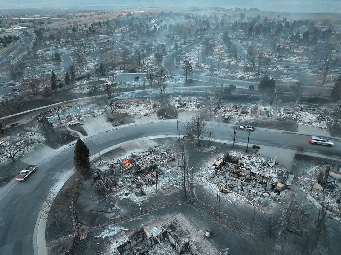
Early Friday morning, about 20 hours after the Marshall Fire ignited, a drone operated by Twitter user WxChasing/Brandon Clement flew over subdivisions that were devastated by the December 30 fire. It found block after block of ash piles, some still smoldering. In many scenes there was scarcely a structure still standing. (Scroll down to see the video.)
All of the reasons why some houses did not burn even though dozens around them were consumed could not be determined from the video, but there was one common feature — the survivors were more distant from the neighboring homes. Many houses in the subdivisions were only 10 to 20 feet apart based on archived imagery in Google Earth.
The fire was driven by very strong winds gusting at 60 to 100 mph, extremely dry conditions after months of drought, and relative humidity in the mid-20s. These are the very worst fire conditions. The weather paired with the nearly back to back structures led to the fire spreading through a continuous human-made fuel bed. When one house burned the convective and radiant heat easily ignited its neighbor, which ignited its neighbor, etc.
The fire in the vegetation and structures lofted burning materials far downwind, creating distant spot fires in the home ignition zone on bone dry lawns, mulch beds around ornamental plants, and on structures. It is unknown at this point how many had been designed and built to be fire resistant, such as the characteristics of the roof, vents, siding, doors, windows, foundation, fences, eaves, and decks. A FEMA publication (13 MB) has excellent detailed recommendations. Headwaters Economics found that the cost of building a fire-resistant home is about the same as a standard home. Local building codes could regulate these features. But if the lot size is so small that residences are only 10 to 20 feet apart, if one becomes fully involved, the neighbors also burn, especially during windy conditions.
So far we have listed some factors that affect the vulnerably of structures during a wildland-urban interface fire: home spacing and lot size, the envelope of the structure itself, fire codes, and the home ignition zone. Others are:
Safety zones where residents can shelter in place;
Road and driveway width, wide enough for large fire trucks;
Turnarounds at the end of roads;
Signage, and;
Emergency water supply.
The video below of the Marshall Fire devastation was shot by WxChasing/Brandon Clement at first light on December 31, 2021, the day after the fire started. Not long after, snow began falling. The National Weather Service in nearby Boulder recorded an accumulation of eight inches.
The fire destroyed hundreds of homes southeast of Boulder, Colorado
Updated at 3:47 p.m. MST Dec. 31, 2021
Photo from a traffic camera in Boulder, CO at 3:44 p.m. Friday. Credit: city of Boulder.
Judging from the photo above taken in Boulder, Colorado at 3:44 p.m. the weather forecast was correct. Forecasters are predicting an additional six inches or so through noon Saturday in the area of the Marshall Fire.
Updated 12:40 p.m. MST Dec. 31, 2021
Boulder County Sheriff Joe Pelle said in a briefing Friday morning that there have been no reports of fatalities on the 6,025-acre Marshall Fire southeast of Boulder, Colorado. That could change as crews assess the impacts of the fire, but if the number remains at zero, it would be very remarkable considering the rapid spread of the blaze which allowed some residents only minutes to escape. It is also a testament to the amazing job done by firefighters and law enforcement to make the necessary notifications, which no doubt saved lives.
Friday morning there is very little remaining fire activity, other than smoldering remains of destroyed structures. Firefighters do not expect the perimeter to grow, especially in light of the snow in the forecast.
The one person reported as missing has been found.
There are 1,778 homes within the perimeter of the fire, but not all of them were affected by the fire, which burned in a mosaic pattern. Some entire subdivisions were “totally gone,” the Sheriff said, including the the Sagamore subdivision just west of Superior and the Old Town Superior area. Dozens more burned homes are west of Superior in the Marshall area, and on the south side of Louisville.
Governor Jared Polis and the Sheriff said Friday that there could be as many as 500 to 1,000 homes that were destroyed. That could be an increase from the estimated 580 figure released by the Sheriff Thursday evening. There were also a number of commercial properties damaged or destroyed.
As entire subdivisions were wiped out, many household plumbing systems were also damaged or destroyed, which led to water gushing from the remains of structures. This depleted the water available at fire hydrants which became a challenge for firefighters. Louisville residents were advised to either boil their water or use bottled water for drinking, making ice, and other uses because the city changed its water distribution to untreated water in its efforts to make water available to firefighters. Other communities with boil water advisories include Superior, Louisville, San Souci Mobile Home Park, East Boulder County Water District, and the Eldorado Artesian Spring water users.
President Biden has approved a disaster declaration which will be finalized Friday. This will expedite approvals of assistance for home owners and small businesses that suffered losses.
Sheriff Pelle said the wind blew down power lines near the point of origin of the fire, but the specific cause has not been confirmed.
On Friday about 200 people were staying in emergency shelters.
The Incident Commander said the strategy during the first few hours was not to attempt to suppress the fire, but the priority was life safety, notifying residents and implementation of the evacuation. With 50 to 100 mph winds, suppression would have been futile. Later when the evacuation was complete and the wind speeds had decreased, they were able to begin working on the flanks.
The Sheriff said “a federal incident commander” will be relieving the IC that has been running the fire since Thursday morning. This sounds like an interagency incident management team (IMT) has been ordered. The National Situation Report dated 7:30 Friday morning lists no fires in Colorado or the assignment of any IMTs. This is an oversight at the National Interagency Fire Center, which is no doubt working with a skeleton staff during the holidays.
The map of the fire was updated late Friday morning, increasing the size by 20 acres, bringing the total up to 6,025. The tweaks were minor and involved a few changes in the perimeter south of Marshall Lake and on the east side near the intersection of Dillon Road and S. 96th Street.
Overnight mapping Thursday night found that the Marshall Fire southeast of Boulder, Colorado had burned about 6,000 acres. The fire started at 10:30 Thursday morning and was pushed by wind that in some areas gusted up to 100 mph while the relative humidity was in the 20s. Tens of thousands of residents have been under evacuation orders. At least 580 homes, a shopping center, and a hotel burned. That number will increase in the coming days as authorities are able to access the area.
Evacuation areas, Marshall Fire. Map accessed at 6:30 a.m. Dec. 31, 2021. More details.
All patients were evacuated from the Avista Adventist Hospital in Louisville. The Good Samaritan Medical Center in Lafayette transferred about 54 of their most critical patients to other facilities.
No deaths have been reported, but at 5 p.m. Thursday Boulder County Sheriff Joe Pelle said, “Due to the magnitude of this fire, the intensity of this fire, and its presence in such a heavily populated area we would not be surprised if there are fatalities.”
Thursday afternoon the Target shopping complex and the Element Hotel in Superior were burning.
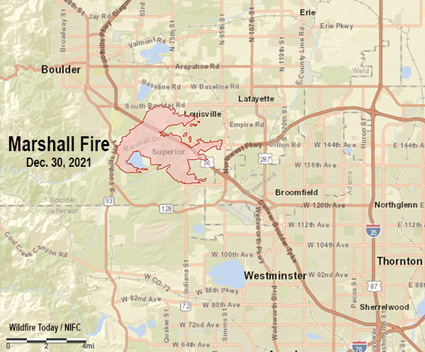
Vicinity Map, Marshall Fire, Dec. 30, 2021.
Fire officials said the cause of the fire was likely downed power lines during the extreme winds.
The weather has changed for the better, as least from a firefighting viewpoint. The 50 to 100 mph winds with low humidities are being replaced Friday morning with temperatures around freezing and a 40 percent chance of snow. By 11 a.m. that chance will increase to 76 percent, then 96 percent by sunset. Snow accumulations are predicted to be 0.6 inch during the day on Friday, with another 5 inches overnight and into Saturday morning. The wind Friday will be out of the north switching to the east at 7 to 9 mph gusting in the afternoon to 16 mph. We don’t often include wind chill in our articles about ongoing wildfires, but that will be a factor today, 250 dropping to 17o by 5 p.m.