Wildfire Briefing, February 5, 2016

The above image is from Headwaters Economics

Land use planning to reduce wildfire risk

Headquarters Economics released a report about how five cities have used innovative land use planning techniques as a way to adapt to the growing threat from wildfires. The authors met with city planners, elected officials, and firefighters in Austin, Texas; Boulder, Colorado; Flagstaff, Arizona; San Diego, California; and Santa Fe, New Mexico—all communities with a recent history of wildfire and a reputation for being problem solvers.
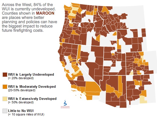
wildfire planning map
Headwaters Economics

Prescribed fire escapes in Florida

In St. Johns County, Florida on Tuesday a prescribed fire intended to treat 140 acres off County Road 208 escaped control when an unexpected 20-25 mph wind gust scattered burning embers. About 270 acres later the Florida Forest Service was able to contain the blaze.

Spokesperson Julie Maddux said statewide in 2015 the Florida Forest Service burned more than 236,000 acres during prescribed fires and none of them got out of control.

U.S. Forest Service releases findings on the effects of drought for forests and rangelands

The U.S. Forest Service this week released a new report, Effects of Drought on Forests and Rangelands in the United States: A Comprehensive Science Synthesis, that provides a national assessment of peer-reviewed scientific research on the impacts of drought on U.S. forests and rangelands. This report will help the Forest Service better manage forests and grasslands impacted by climate change.

“Our forests and rangelands are national treasures, and because they are threatened, we are threatened,” said Agriculture Secretary Tom Vilsack. “This report confirms what we are seeing, that every region of the country is impacted by the direct and indirect effects of drought conditions and volatile weather patterns. Sixty million Americans rely on drinking water that originates on our 193 million acres of national forest and grasslands. They support 200,000 jobs and contribute over $13 billion to local economies every year.”

Utah seeks jail time for drone operators that interfere with wildfire operations

Last year there were numerous instances across the West of drones flying into the airspace above active fires and interfering with the operations of firefighting aircraft.

From the AP:

..A new proposal in the Utah Legislature aims to address the growing problem by creating a possible penalty of jail time for people who fly drones within 3 miles of a wildfire.

A House committee was scheduled to discuss the proposal Tuesday afternoon but the hearing was postponed.

Republican Rep. Kraig Powell of Heber City, the proposal’s sponsor, said he asked to postpone the meeting so he could get more input from interested parties. He said he may add exemptions for certain entities, such as public utility companies that need to use drones to see if the fire will impact gas lines.

Jason Curry of the Utah Division of Forestry said he hopes lawmakers back the bill…

“I really hope it doesn’t take a major mishap and somebody to lose their life for the public to take it seriously,” Curry said.

Washington state treats less land with prescribed fire than their neighbors

Washington prescribed fire acres

From the Seattle Times:

Washington lags far behind neighboring states in using controlled burns to thin out dangerously overgrown woodlands.

After back-to-back years of catastrophic forest fires, some state lawmakers want that to change.

“I’ve had it. I think it is time to delve into the policy,” said state Sen. Linda Evans Parlette, R-Wenatchee, who represents a large swath of North Central Washington scorched in last year’s record-setting fires that burned more than 1 million acres.

Parlette is sponsoring a pair of “fight fire with fire” bills that would require more controlled burns on state lands and loosen smoke regulations to make it easier for federal and private land managers to conduct burns.

Experts say expanding the use of controlled burns is vital to restoring forests to health, leaving them less vulnerable to massive blazes when the summer fire season hits.

But some U.S. Forest Service officials and other critics say the state’s Department of Natural Resources (DNR), led by Commissioner of Public Lands Peter Goldmark, has discouraged controlled burns in recent years because of fears over smoke drifting into communities.

Pile burning in the Black Hills

pile burn
Black Hills National Forest burns slash piles. USFS photo.

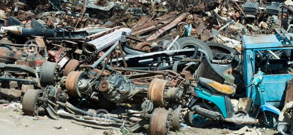
The Black Hills National Forest in South Dakota and Wyoming is taking advantage of the recent snow to ignite some large slash piles left over from thinning or logging operations. Constructed with mechanized equipment, the Forest likes to call them “machine piles. If a person is not familiar with the practice, it may cause them to envision piles of machines:

pile of machines

Choices about fire: when do you want it and what do you want it to do?

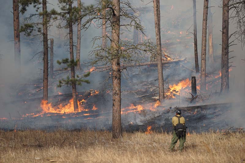
Whaley prescribed fire
A firefighter keeps an eye on the Whaley prescribed fire northeast of Hill City, SD, January 14, 2016. Photo by Bill Gabbert. (click to enlarge)

A student in the Environmental Science Journalism program at the University of Montana wrote an article examining how the media covers wildland fires. In addition to talking with reporters, Andrew Graham extensively quoted Mark Finney of the USDA Forest Service’s Missoula Fire Science Laboratory. You should read the entire article, but here is an excerpt.

There is a choice to be made with fire, which Finney says is not made clear to the public.

“We’ve proven that we cannot keep fire out. It is inevitable, it will occur. Everywhere there’s fuel, you will have fire. Your choice is, when do you want it and what do you want it to do? That’s all you have, those are your choices. Your choices are not whether to have fire or not.”


Thanks and a tip of the hat go out to Tom.

Prescribed fire held in check partially by snow

When I heard this morning that the Black Hills National Forest was going to conduct a 94-acre prescribed fire today I looked out my window at the snow in my yard. Curious about how they were going to accomplish this I departed on a expedition to answer this question. It being close to lunch time I stopped at the Dew Drop In for a burger and their wonderful homemade fries, and then again at the TurtleTown chocolate shop for, obviously, a bag of chocolate turtles.

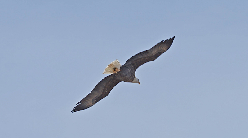
Passing near the Crazy Horse mega-sculpture I saw two bald eagles on the ground in a pasture. I pulled over onto a nearby side road hoping to get a photo, but they were pretty skittish and rudely flew away. But I still grabbed a few not very impressive photos.

Bald eagle
Bald eagle
Bald eagle
Bald eagle

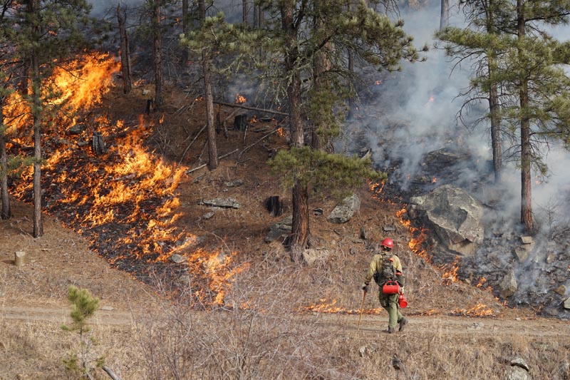
By the time I made it to the Whaley prescribed fire near Hill City, South Dakota, I was no longer hungry and was ready to see how the the U.S. Forest Service fire folks were going to pull this off.

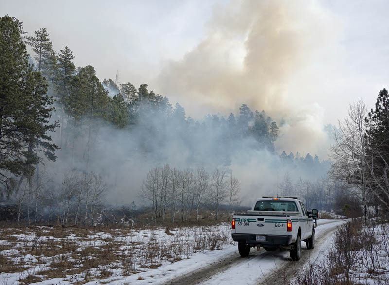
Whaley prescribed fire South Dakota

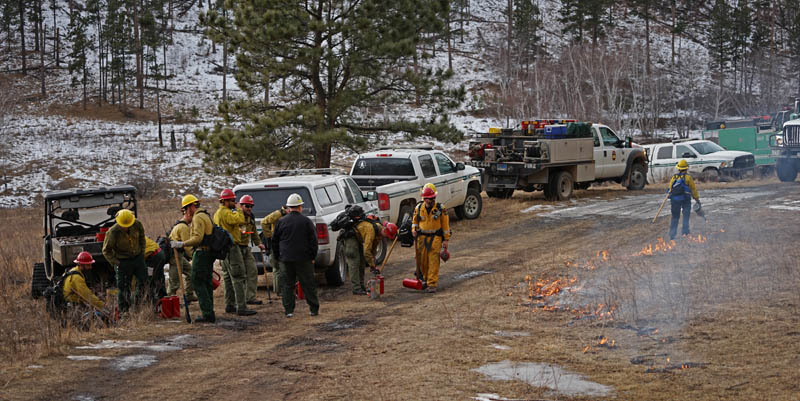
It turned out that there was almost no snow on the south facing slopes and they were about 75 percent done with ignition when I pulled up. But there was still snow in some of the flat lands and shaded areas, enough to make it pretty easy to find snow fields, in addition to roads, to serve as control lines.

At the Elk Mountain weather station the temperature was in the 40s, the relative humidity in the low 30s, and the sky was partly cloudy. As it turned out, a good day for being out in the woods with a drip torch.

Whaley prescribed fire South Dakota

The video at the top of the article includes still photos, video clips, and an interview with Todd Pechota, the Fire Staff Officer for the Black Hills National Forest.

Whaley prescribed fire South Dakota


Whaley prescribed fire South Dakota

Continue reading “Prescribed fire held in check partially by snow”

National survey – the use of prescribed fire

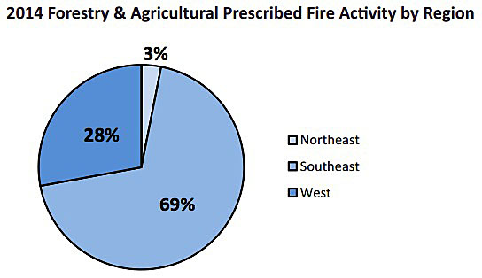
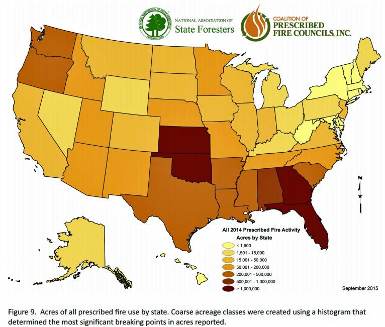
The National Association of State Foresters and the Coalition of Prescribed Fire Councils recently completed their second national survey of all 50 states, asking questions about how prescribed fire is used, managed, and reported. They found that after sorting the responses into three regions, Northeast, Southeast, and West, 69 percent of all acres burned were in the Southeast in 2014.

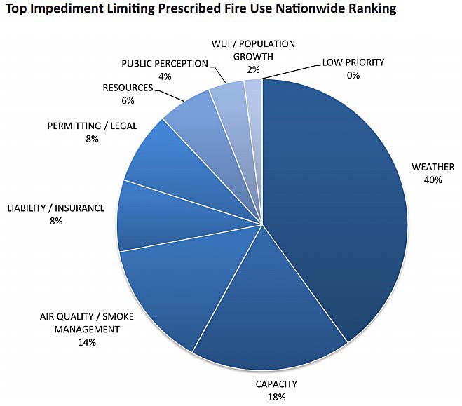
The top impediments to accomplishing their prescribed fire objectives were, in decreasing order, weather, capacity, and air quality/smoke management.

Below is an excerpt from the report, and below that some graphics. (click on the images to see larger versions)

One significant finding was an increase in the number of states that offer education and training to certify prescribed fire managers. The number of states increased to 24, a 41% increase over the 2012 report. This is an impressive statistic, and one that will hopefully build capacity of trained fire managers. During the same period, the number of prescribed fire councils grew by 24%, bringing the total to 31 councils in 27 states.

prescribed fire activity by region

prescribed fire acres by state

States tracking Rx fire activity

Top impediment prescribed burning

Pyrocumulus over a pile burn

Sundance pile burn pyrocumulus Dave Porter

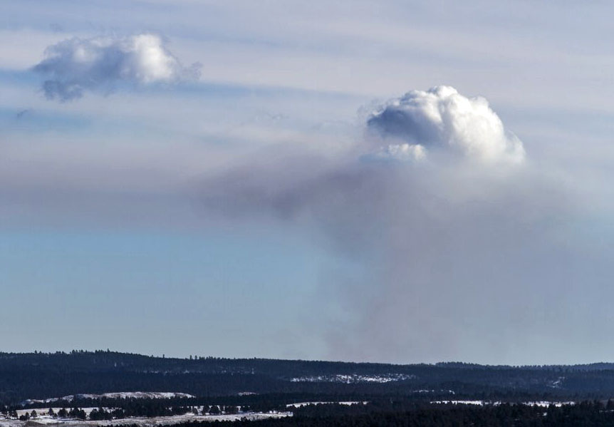
Dave Porter of the Black Hills National Forest captured this image of a pyrocumulus cloud January 6 over a pile burning project southeast of Sundance, Wyoming.

A pyrocumulus over a pile burn is rare.

From Wikipedia:

A pyrocumulus cloud is produced by the intense heating of the air from the surface. The intense heat induces convection, which causes the air mass to rise to a point of stability, usually in the presence of moisture. Phenomena such as volcanic eruptions, forest fires, and occasionally industrial activities can induce formation of this cloud.

An article posted earlier today about the bushfire in Western Australia had a photo showing a pyrocumulus cloud over the fire.